Environment
By Eugenia Naranjo, VKI
Abstract:
Nonpoint pollution comes from diverse, hard to identify sources and therefore it is difficult to estimate. The use of Geographical Information Systems provides an extensive approach to evaluate land use and other mapping characteristics to explain the spatial distribution of nonpoint source contamination. A simple method to assess nonpoint pollution has been developed for integrating GIS, databases, as well as transport and decay of pollutants in a watershed. The output from the model can be linked to an existing water quality model (MIKE 11).
1. Introduction
The main sources of river pollution are usually point sources originated from household and industrial discharges as well as diffuse pollution generated by agricultural and urban runoff. Characterizing pollutants requires extensive knowledge of the areaís geography and nonpoint sources, therefore the possible point and diffuse sources of pollution must be identified and located in order to be assessed.
The kind of pollution associated with each different land use has to be identified depending on the local situation and on the availability and reliability of data. The main kinds of pollution loads are
- Pollution loads from domestic sources generated by households
- Pollution load from industrial sources
- Pollution loads from agriculture
In order to carry out a complete pollution load assessment, information on the extent of watershed basin, type of population (urban, rural), industries (type, type of wastes), land uses, climate (rainfall), vegetation, soil types, sewage (percentage of population sewered, water supply, infiltration of sewage, treatment, etc.) and type of treatment s needed.
Different approaches can be used to study nonpoint pollution. A GIS is a computer system capable of spatially representing data on the land surface and linking additional data related to this spatial depiction, through tables and charts. Furthermore, GIS is used in the area of environmental modeling, by providing ease and accuracy in surface terrain representation, watershed delineation, precipitation, data compilation, non-point source pollutant loading calculation and other concepts related to environmental processes. Consequently GIS has emerged as a powerful modeling tool which can help provide the knowledge necessary to make management decisions.
An ArcView Geographic Information System (GIS) application has been developed for the assessment of nonpoint source pollution including scattered domestic and industrial loads in a watershed. The method makes use of publicly available elevation data, stream network, rainfall, discharges and land use data sets and uses a grid representation, of the watershed for the estimation of average annual pollutant loads.
2. The nonpoint pollution model
Nonpoint pollution models are basically a description of the hydrologic rainfall-runoff transformation processes with attached quality components (Notovny, V. and Chesters, G., 1981). Nonpoint sources are derived from activities on extensive units of land, originating from urban runoff, construction, hydrologic modification, silviculture, mining, agriculture, irrigation return flows, solid waste disposal, atmospheric deposition, stream bank erosion, and individual sewage disposal (Robinson and Ragan, 1993).
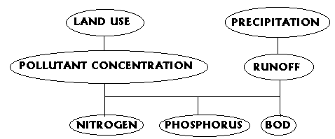
In recent years, the use of GIS has increased in order to identify and assess erosion and nonpoint pollution. A GIS can combine automated cartographic features with database management capabilities as shown in Fig. No. 1
ê
total annual load
Fig. No. 1: Nonpoint Pollution Model
Models may vary in their scope and capabilities but however some generalization of the input data requirements have to be done:
- watershed size
- river network
- topography
- agriculture and vegetation cover
- sewer systems
- land uses
- rainfall
The following four steps, define the procedure for calculating pollution loads generated by non-point sources:
3. The main model parameters
3.1. Water quality parameters
Four water quality parameters have been selected for quantification of nonpoint pollution (Rifai et. Al., 1993).
- Total nitrogen (TN) = all the various forms of inorganic and organic nitrogen
- Total phosphorus (TP) = orthophosphate and organic phosphorus.
- Biochemical Oxygen Demand (BOD) = measure of biodegradable organics in the water
- Fecal coliforms = bacteria present in the intestines or feces of humans and warm blooded animals. E.Coli is primarily originated from domestic pollution.
3.2. Land use and nonpoint pollution
The term land use describes the prevailing activity taking place in a uniform demographic area. For pollution studies land uses must be grouped together or categorized according to homogeneous characteristics because land use has a direct effect on the water quality. Two major groups would be rural and urban lands; these at the same time can be categorized according to the following division:
- Agriculture
- Forests
- Idle land (land not used for active agricultural purposes)
- Wetlands
- High density urban
- Residential land
- Industrial land
3.3. Estimated Mean Concentrations
Estimated Mean Concentrations (EMCs) are typical pollutant values found in the runoff. These EMC values are assumed to be directly related to land uses in the drainage areas and constant independently of the duration and intensity of the rainfall events.
The land use would be associated to a Concentration database. The values in this table are typical concentrations of pollutants found in runoff water from each particular land use from areas in Texas. (Saunders, W. and Maidment, D., 1996).
Table 1: Runoff estimated concentration values (mg/l)
Land use category |
TN |
TP |
BOD |
| High Density Urban Residential Agricultural Open/Pasture Forest Wetlands Water Barren |
2.10 3.41 1.56 1.51 0.83 0.83 0.00 5.20 |
0.37 0.79 0.36 0.12 0.06 0.06 0.00 0.59 |
9 15 4 6 6 6 0 13 |
Source: Benaman, J., 1996
TP = total phosphorus (mg/l)
BOD = total BOD (mg/l)
3.4. Runoff Coefficients
In order to assess the transport of pollutants in a region, an understanding of the means by which the loads migrate is required. Nonpoint source pollutants are carried over land and into the river network of a region by direct runoff. After the extent of the watershed has been determined, it is necessary to obtain an average runoff volume generated. This runoff is largely the result of precipitation over the area. In hydrology, it is common to use runoff coefficients to help characterize the amount of runoff produced from a given storm event for a given area (Chow, 1988).
Moreover, a relative measure of the urbanization of an area is provided by runoff coefficients, by assigning high values to paved areas and low values to open, grassy lands. The total runoff for a given watershed will be calculated by multiplying the total rainfall by the runoff coefficients in that respective watershed. The coefficients found in Table No.2 were chosen from researched literature and assigned to each land use.
Table No.2: Runoff coefficients per land use*
| Land use | Runoff Coefficient |
| 1 Urban 4 Open 3 Agriculture 8 Barren 6 Wetlands 2 Residential 7 Water 5 Forest |
0,89 0,22 0,24 0.22 0.80 0.34 1.00 0.15 |
Source: Benaman, J., 1996
*Assumptions: Soil type D, design storm 25 yrs
4. Methodology
A digital grid replica of the basin stream network is first created, employing a "burn-in" process to affix the digitized stream network to the Digital Elevation Model of the basin (Oliveira, 1996). Literature based Expected Mean Concentrations (EMCís) of pollutant constituents are associated with land uses in the watershed. Finally, the products of these spatially distributed EMCís and the runoff in each digital basin grid cell are calculated and then summed in the downstream direction to establish distributed grids of average annual pollutant loads in the river.
4.1. Watershed Delineation
Before starting the Nonpoint pollution Model we must be sure that the watershed is defined properly and that we have obtained the exact river network. The standard methodology for delineating streams and watersheds from a raster digital elevation model (DEM) is based on the eight-pour point algorithm (Jenson, S. and Domingue, J, 1988). This algorithm identifies the grid cell out of the eight surrounding cells, towards which water will flow if driven by gravity.

Figure 2: Eight-Direction Pour Point Model
Source: Saunders and Maidment, 1996
This methodology consists of ((Oliveira, 1996):
- Filling the sinks of the DEM, i.e., increasing the elevation of the points that are fictitious pits.
- Determining the flow direction, i.e., identifying the cell towards which water will flow
- Identifying the stream cells, i.e., marking down those cells with a flow accumulation value greater than a certain user-defined threshold value
- Labeling the links, i.e., assigning a label (number) to each reach of the stream network.
- Delineating the watershed for each link, i.e., determining the drainage area associated with each link.
A prior process has been added to this methodology, and it consists of burning-in the digitized streams. This process consists of raising the elevation of all the cells but those that coincide with the digitized streams (Olivera, F., 1996). By doing this, the water is forced to remain in the streams once it gets there. The process consists of:
- Converting the line theme of the digitized river into a grid (with a value of 1 in the stream cells and NODATA elsewhere)
- Adding a constant value to the DEM
- Merging the two grids together, keeping the stream grid on top of the modified elevation grid, to obtain a burned DEM.
Once the filled hydrologic digital elevation model has been created, it can be processed to determine the direction of the flow of water and therefore pollutants from cell to cell and to determine, for each cell in the grid, the number of cells that are upstream.

Figure 3: Burned- in DEM Streams
Source: Maidment et.al
4.2. Calculation of EMCís
4.2.1. Direct runoff
Loads for total nitrogen, total phosphorus, and BOD can be estimated by applying pollutant concentrations to annual runoff volumes. There are different mean runoff concentrations for each land use category.
Runoff = subcatchment area * annual rainfall * runoff coefficient
The model then applies the mean runoff concentration based on the land use in each subcatchment and applies it to the runoff, resulting in loads for each pollutant.
Load = runoff * EMC
4.2.2. Transport and decay of nutrients in the runoff
Pollutants generated at a certain location are subject to degradation and transformation processes. Such processes affect the transport of substances between that location and the nearest downstream point in the river included in the river water quality model setup. These processes have been combined into one decay function depending on the estimated travel distance from each grid to the nearest downstream river point. In reality, the decay will depend on a number of factors, such as water temperature, subsurface or surface runoff, and mainly travel time to the river. However, since the model uses a steady state approach time of travel can be correlated to distance to the river. The distance used is not the true travel distance for a polluting particle, but the distance from the generation of the pollution to the nearest downstream point in the river included in the river water quality model. Hence, depending on the course of the channel and stream network discharging into the river, the estimate of the travel distance will be a more or less precise estimate of the true travel distance. Consequently, the decay constant should be interpreted as a lumped parameter subject to calibration according to actual pollution load transport.
Transport and decay of nutrients in the runoff will be described according to the following equations:
NT= NR* exp(kN, run* drun)
PT= PR * exp(kP, run* drun)
BODT= BOD * exp(kBOD, run* drun)
Where:
NT = total N-transported into the river system (kg N/ha*yr)
PT = total P-transported into the river system (kg P/ha*yr)
BODT= total BOD-transported into the river system (kg BOD/ha*yr)
NR = total N- in runoff in a given subcatchment (kg N/ha*yr)
PR = total P- in runoff in a given subcatchment (kg P/ha*yr)
BODR= total BOD-in runoff in a given subcatchment (kg BOD/ha*yr)
kN, run= first order N-decay rate in the runoff (km-1)
kP, run= first order P-decay rate in the runoff (km-1)
kBOD, run= first order BOD-decay rate in the runoff (km-1)
d riv= travel distance from subcatchment location to river (km)
4.2.3. Including scattered domestic and industrial point sources of pollution
Pollution loads originated from small settlements and industries in the catchment area are difficult to estimate due to their scattered nature. These are usually not point sources discharging into the main river, hence to assess the pollution loads generated by the households and small industries in the area, data on population, percentage of sewered population and population served by some kind of treatment is needed.
Pollution Loads from Domestic Sources depend on the per capita waste production and the type of treatment applied.
Total discharge = per capita waste production* number of inhabitants * percentage of population sewered * percentage of pollutant remaining after treatment
The % of pollutant remaining after the treatment will depend directly on the type of treatment applied.
The per capita pollution load generated varies from country to country depending on the habits and living conditions of the population. Most countries however, have estimated unit load values. When the per capita load is unknown the following per capita loads are recommended depending on the standard of living of the region in study.
Country group Standard of living A B
C
D
low moderate
high
supreme
Estimated BOD, Nitrogen, Phosphorus and E.Coli per capita load values
Table No. 3: Estimated per capita load (kg/P*yr)
Pollutant |
A |
Country |
Group |
D |
BOD5 Phosphorus Nitrogen E.Coli |
13 0.5 4 1010 |
16 0.8 4 1010 |
19 1.1 4 1010 |
22 1.1 5 1010 |
Source: Henze, Mogens.
Loads from large industrial plants should be monitored in order to quantify the pollution generated. Based on existing figures and measurements, these loadings have to be included to assess the total pollution generated However, in order to assess and to take into account the loads generated by small local industries in the present model, the per capita pollution loads are increased by a fixed percentage.
Table No. 4: Percentage increase in per Capita Pollution Load caused by local industry
Pollutant |
A |
Country |
Group |
D |
BOD5 Phosphorus Nitrogen |
10 5 5 |
20 10 5 |
30 15 5 |
40 20 10 |
Source: Henze, Mogens.
5. Application case
The ArcView Nonpoint extension works as an ArcView add-on extension and it requires the Spatial Analyst module as well. The Nonpoint extension will estimate the total diffuse pollution generated by different human activities as well as natural and will calculate how much of it gets into the river system. Finally the model will create a file to be used as input to the MIKE 11water quality model for the river system.
In order to develop a simulation and monitoring program for the Iguacu river basin in Brazil the nonpoint pollution model was used to estimate the total annual pollutant loadings into the river system.
5.1 Including the data in the model
Based on the existing land use maps and known agricultural practices in the Curitiba region, a land use classification was carried out and a pollutant concentration database was generated for the region. The following table shows the land use categories used for the Iguazu river basin. However, no wetlands or barren lands were identified in the study area.
A digital land use map of the catchment was generated in ArcView:
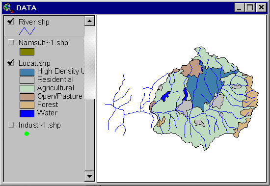
Figure 4: Land Use Map of the Iguazu River Basin
Land uses have been associated to the estimated concentration database hence the runoff concentration values have been joined to the appropriate digitized land use polygon. The model has an integrated database with literature-based expected mean runoff concentrations (EMC values) which are assumed to be directly related to land use in the catchment. These default values are typical concentrations of pollutants found in the runoff from each pre-defined land use. The mean runoff concentration values (mg/l) were joined to the appropriate polygon in the land use coverage (Table No.2). Henceforth the total pollution generated by each land use polygon would be estimated. Table 2 shows typical runoff EMC values for pre-defined land uses.
The table with the default concentration values was joined to the land use map and therefore an attribute database with all the pollutant concentrations and runoff associated to the land uses was generated.
2. Topography
A 30 arc-second digital elevation model (DEM) was obtained from the U.S. Geological Survey. With this DEM plus the digitized river network a "Burn DEM" was generated for the area in study
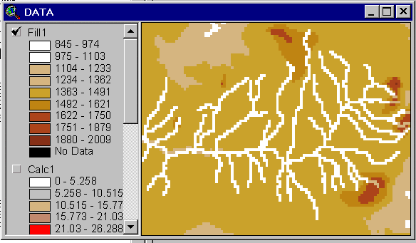
Figure 5: Burned-in DEM
With the land use map and runoff grid a "BOD" load grid will be generated. In order to include decay rates a distance to the river grid has to be generated, and afterwards the pollutants will be routed to the river.
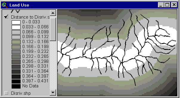
Figure 6: Distance to river grid
3. Population
Data on geographical distribution of settlements, population and sewered population was obtained per sub-basin. Data for the year 1991 and projections for the year 1995 were available. With the population density and the type of treatment in each subbasin, the domestic pollution loads generated in the whole catchment was estimated. The process to calculate the pollution that get into the river follow the same steps as the nonpoint pollution.
Merging both accumulated grids will generate a grid of accumulated pollutants
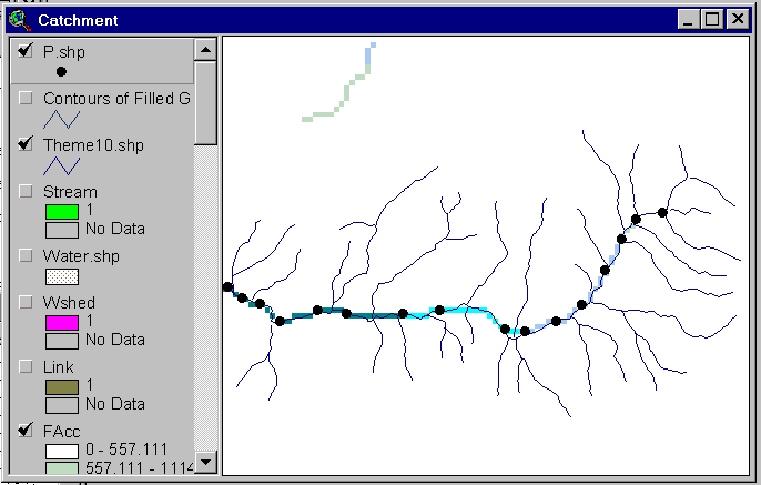
Figure 7: BOD accumulated grid
5.2 Calibration and verification of the Model
The pollutants were routed in the watershed using the Accumulation command and the total amount of pollution generated by the land uses as well as the domestic and industrial pollution that reach the river system was estimated. Both grids were merged and in two stations 14 (downstream) and 24 (upstream) (in the Iguazu River), the following results were obtained.
First results using the values in tables 3 and 4 are shown in Table 5
Table 5: Model Results
Pollutant |
Measured 14 |
Estimated |
Measured 24 |
Estimated |
BOD5 Phosphorus Nitrogen |
6 525 858 335 684 4 681 740 |
7 707 832 670 412 3 054 413 |
5 624 270 306 869 3 257 353 |
5 932 554 492 449 2 270 574 |
The following parameters have been modified in order to calibrate the model:
Phosphorus percentage increase in domestic pollution caused by local industries = 5%
Phosphorus per capita yearly load in domestic sewage for sewered population =
0.8 kg/c*yr
Phosphorus per capita yearly load in domestic sewage for non sewered population =
0.5 kg/c*yr
Nitrogen per capita yearly load in domestic sewage = 7 kg/c*yr
Table 6 shows the calibration results
Table 6: Calibration results
Pollutant |
Measured 14 |
Calibrated |
Measured 24 |
Calibrated |
BOD5 Phosphorus Nitrogen |
6 252 850 335 684 4 681 740 |
7 707 832 571 052 4 572 620 |
5 624 270 306 869 3 257 353 |
5 932 554 380 764 3 481 190 |
It is important for simulation models to produce distributions of pollutant loads are similar to those measured. Calibrated results show a close agreement between the measured data and the results obtained. However, note that still the calibrated values for station 24 are closer to the measured data than those from station 14. The reason for this may be that the nonpoint model does not consider degradation of pollutants in the main river.
6. Conclusions
Only average annual assessments are performed, so that runoff and pollutant loads are considered to be steady state parameters from year to year within any year. However, average monthly assessments could be easily performed using the same method.
The literature-based expected mean runoff concentrations are assumed to be directly related to land use in the catchment and are not considered to vary from event to event or between different land use subcategories. However, pollutant concentrations in runoff are known to vary within single rain events, depending on factors not considered in the present model. Therefore, the model should not be used to simulate detailed dynamics in short time scale.
REFERENCES
Saunders, William and Maidment, David (1996). A GIS Assessment of Nonpoint Source Pollution in the San Antonio-Nueces Coastal Basin. Center for Research in Water Resources, The University of Texas at Austin. Austin, Texas.
Benaman, Jennifer, Armstrong, Neal and Maidment, David (1996). Modeling of Dissolved Oxygen in the Houston Ship Channel using WASP5 and Geographic Information Systems. Center for Research in Water Resources, The University of Texas at Austin. Austin, Texas.
Olivera, Francisco (1996). Spatial Hydrology of the Urubamba River System in Peru using Geographic Information Systems (GIS). Center for Research in Water Resources, The University of Texas at Austin. Austin, Texas.
Maidment et.al. GIS and Hydrologic Modeling: An Assessment of Progress. On line Powerpoint presentation. ). Center for Research in Water Resources, The University of Texas at Austin. Austin, Texas.
VKI, Denmark, Instute of Geography, Lithuania and Klapeida University, Lithuania (1994). Runoff of Nutrients from Minija River Basin. VKI, Hørsholm, Denmark.
Henze, Mogens. L40 Pollution Source Assessments. Department of Sanitary Engineering, Technical University of Denmark, Denmark.
Adamus, Christine and Bergman Martinus (1995). Estimating Nonpoint Source Pollution Loads with a GIS Screening Model. WaterResources bulletin Vol. 31, No. 4, pp. 647-655.
Jenson, S.K. and Domingue, J.O. (1988). Extracting Topographic Structure from Digital Elevation Data for Geographic Information System Analysis. Photogrammetric Engineering and Remote Sensing, Vol. 54, No. 11, pp. 1593-1600.
Rifai, Hanadi, Newell, Charles and Bedient, Phillip (1993). Getting to the Nonpoint Source with GIS. Civil Enginnering, Vol. 63, No. 6, pp. 44-46.
Notovny, Vladimir and Chesters, Gorgon (1981). Handbook of Nonpoint Pollution Sources and Management. Litton Educational Publishing Inc., New York, USA.
Corbitt, Robert A. (1990). Standard Handbook of Environmental Enginnering. McGraw-Hill Inc., USA.
Terrene Institute, Washington D.C. and Region 5 US Environmental Protection Agency, Chicago, Illinois (1996). A Watershed Approach to Urban Runoff. Handbook for Decisionmakers. Terrene Institute, Alexandria, Virginia.
U.S. Geological Survey (1997). South America DEM (CD-ROM). EROs Data Center, Sioux Falls, S.D., USA.
Chow, Ven Te, Maidment, David and Mays, Larry (1988). Applied Hydrology. McGraw-Hill Book Co. Singapore.