Waldemar Gogolek, Tomasz Bielecki, Aldona Jurkun, Jacek Kocyla, Jacek Zielke
This paper depicts the state of cartographic production of The 1:50,000 Detailed Geological Map of Poland and the state of capturing data for database. The aims, database structure, software application, methods of capturing data, hardware and software are described. ArcInfo 7.0.2 and Oracle 7 are used for computer-aided production of our map and database. The process of digitising is very quick, but data loading is a slow procedure, because of the large amount of data and its detailed verification. Accuracy of source data is the most important factor for efficiency of the database and computer-aided map production.
Polish Geological Institute has main responsibility for geological cartography in Poland. Poland has been mapped at 1:200,000, 1:50,000 and partly at 1:25,000. At present The 1:50,000 Detailed Geological Map of Poland is being produced.
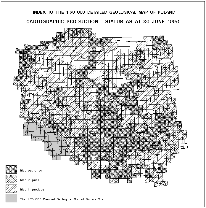
Geological map production at a scale of 1:50,000 has continued since 1953. 1025 map-sheets at a scale of 1:50,000 and 44 maps of The 1:25,000 Detailed Map of Sudety Mountains cover the whole area of Poland. Up to now finished and published maps have covered about 50% of our country, maps in production - 35%. Geological maps at a scale of 1:50,000 are produced in State Projection "1942" (Gauss-Kruger) Projection. This projection "1942" was used in the 1950s and again since 1993. Other projections, called "Borowa Gora", "1980" and "1965", were used in the mean-time. Production of the 1:50,000 geological map became more intensive in the1980s and 1990s. Tens of geological maps are finished every year. We have decided to use computer methods to increase the effectiveness of map producing and especially editing. The state of map production is shown in Figure 1.
Computer aided production of The 1:50,000 Detailed Geological Map of Poland started in 1994. ArcInfo 7.02 and Oracle 7 were selected as software tools. The aims of computer-aided production are as follows:
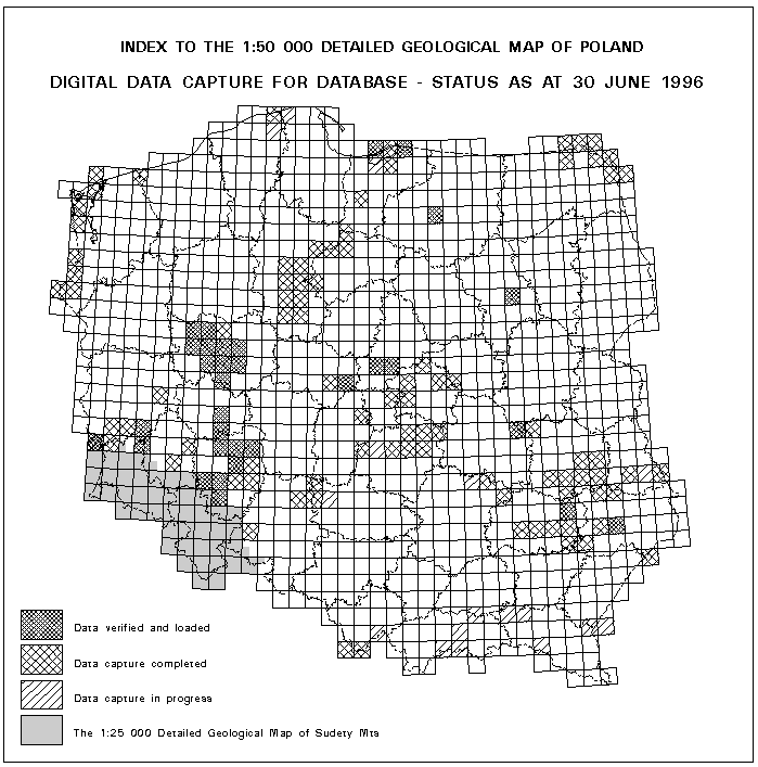
121 maps have completed capturing of spatial and attribute data. 36 maps have been loaded to database. The state of data capturing is shown in Figure 2.
Many geologists, editors and GIS specialists from Polish Geological Institute, its regional branches, geological business and GIS companies take part in the program of computer-aided production of 1:50,000 geological map. The program was realised in strict co-operation with the Polish Geological Institute and Neokart GIS Company. Ministry of Environment Protection, Mineral Resources and Forestry with National Fund of Environment Protection and Water Administration manage and finance the program.
Discussion of the database of The 1:50,000 Detailed Geological Map of Poland was presented in 1995 (Gogolek 1995; Jurkun, Zielke 1995a, 1995b), during 10th ArcInfo European Users Conference in Prague.
The main features of database are as follows:
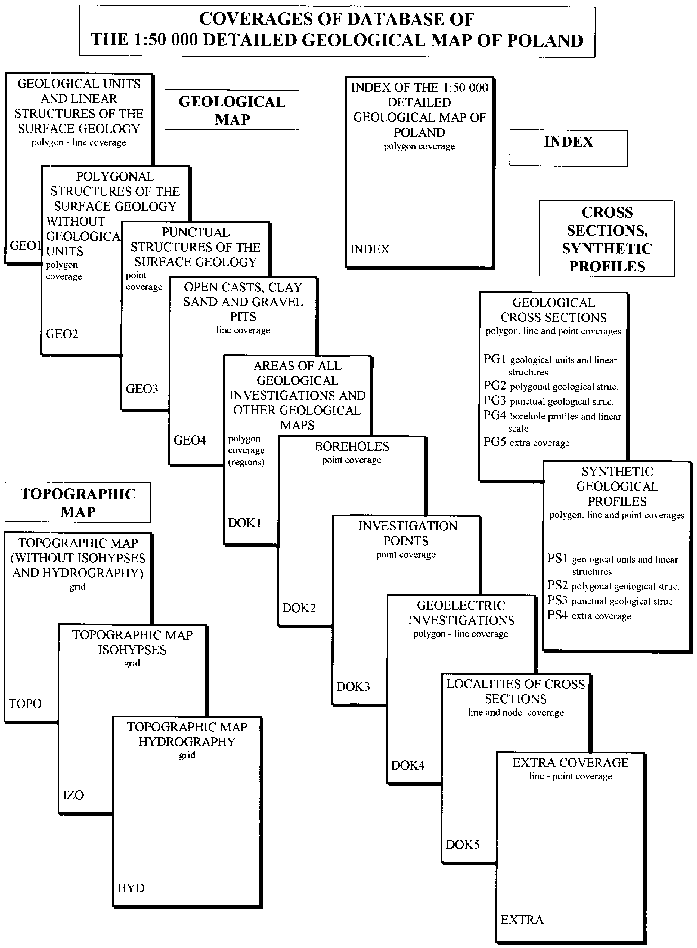
Several new coverages were added to database during 1995. Database structure was verified too. Actual database structure is shown in Figure 3.
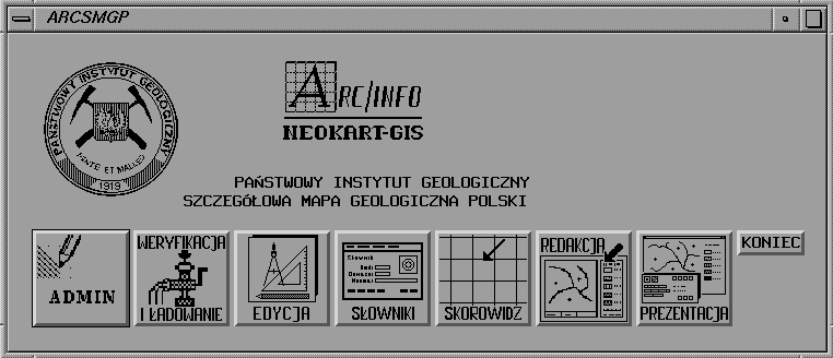
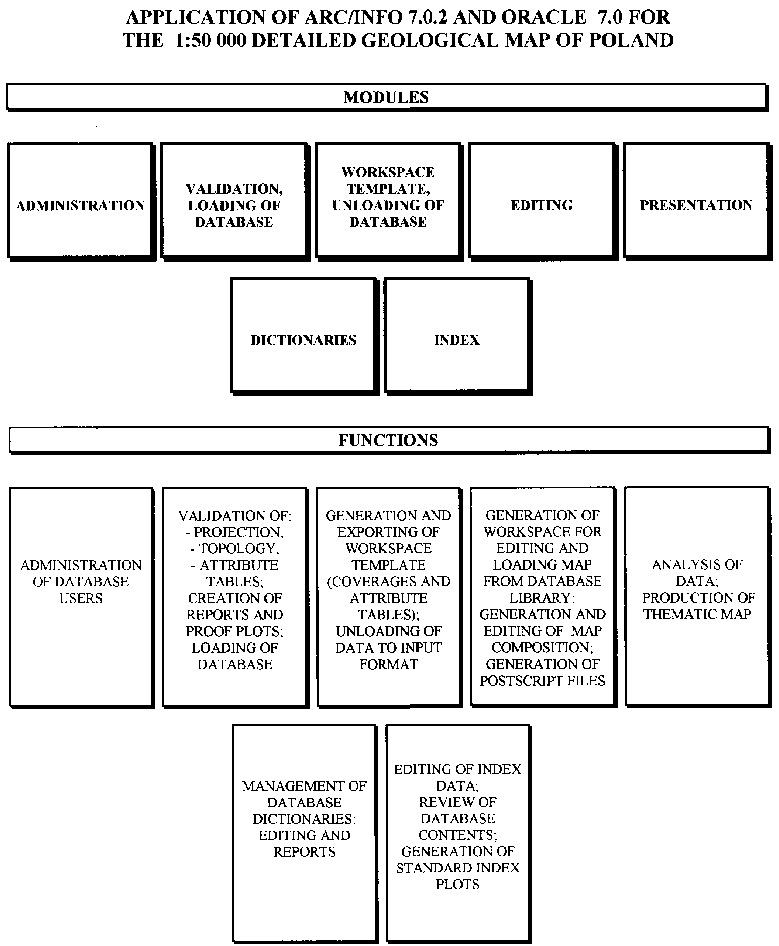
The application of ArcInfo and Oracle was developed for production, management, analysis of data and for digital editing of geological maps at a scale of 1:50,000. It consists of seven separate modules, two modules more than a year ago (see below - Figure 4).
Now, the most frequently used modules, are verified and their functions are supplemented. Verification procedures were supplemented by elements of coverages statistics, automatic correction of coverage topology and projection parameters. Control of data consistency for boreholes (e.g. height a.s.l., depth of boreholes and geological units) was developed. Procedures of map composition (e.g. geological map, explanations, synthetic profiles and cross section) were developed too. The basic rule was to preserve the uniformity in computer-aided editing. The application was described by Jurkun and Zielke (1995a, 1995b) a year ago, but the actual structure of the application, its modules and functions is shown in Figure 5.
Geometric data are digitised from manuscripts of geological maps and cross sections at a scale of 1:25,000. Synthetic profiles are produced by the map authors at the same or other scales. Maps are drawn in the background of topographic maps in Gauss-Kruger projection (1942"), according to the coverage topology of input data, database dictionaries and "Instruction of The 1:50,000 Detailed Geological Map of Poland production". Attribute data are collected from tables and registers prepared by map authors and these data are coded according to the database dictionaries. All digitised data have to be compatible to the standard database.
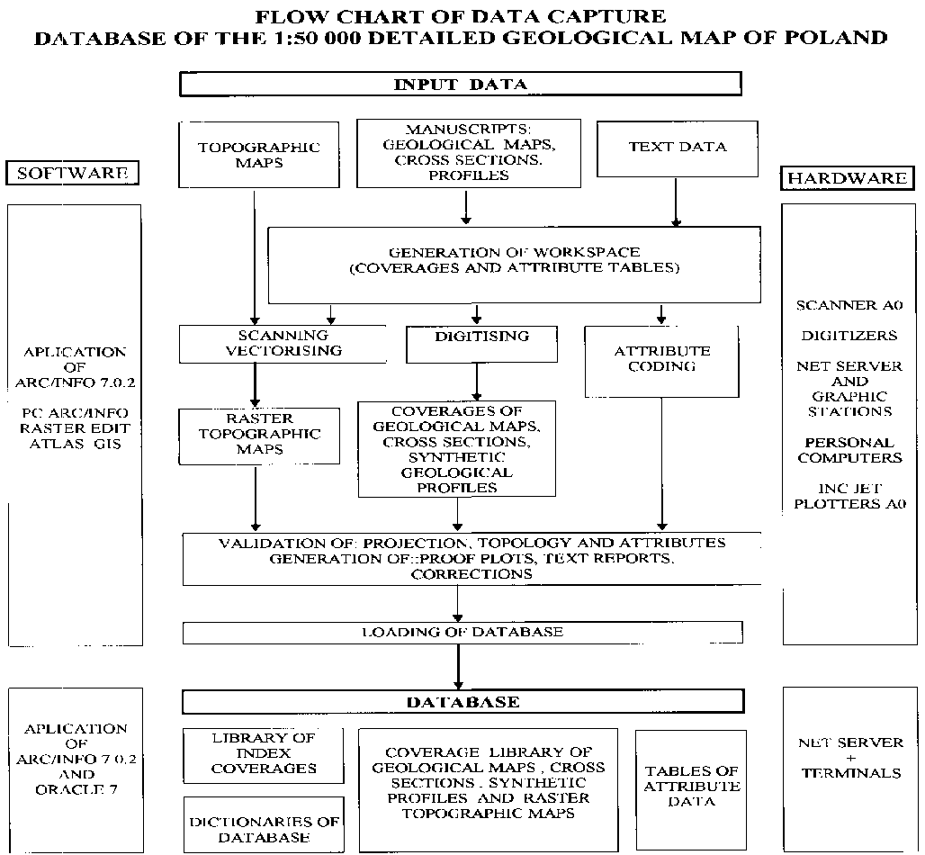
Because many people collect digital data and take part in the computer-aided production of the 1:50,000 geological map, a variety of methods, software and hardware are used for digitising data for the database. But primary software is ArcInfo, the other software is secondary. Netserver, graphic stations, personal computers and peripheral devices as scanners, plotters, printers are connected in local network. Silicon Graphics Inc. Challenge L is net server of Polish Geological Institute. S.G. Indigo 2 and Indy computers are graphic stations for geological cartographers of Institute. One of the first steps of capturing data is presented by Bielecki (1996). Figure 6 shows a flow chart for data capture.
The final and may be the most important stage of computer-aided production is editing of the 1:50,000 geological map. The module called "Editing" contains all necessary procedures to produce professional geological maps. These procedures are described by Jurkun and Zielke (1995a, 1995b). Until now six maps have been finished and these maps are ready to print. Figure 7 shows the sheet of Janow Lubelski (858) of The 1:50,000 Detailed Geological Map of Poland, finished using the ArcInfo methods and application.
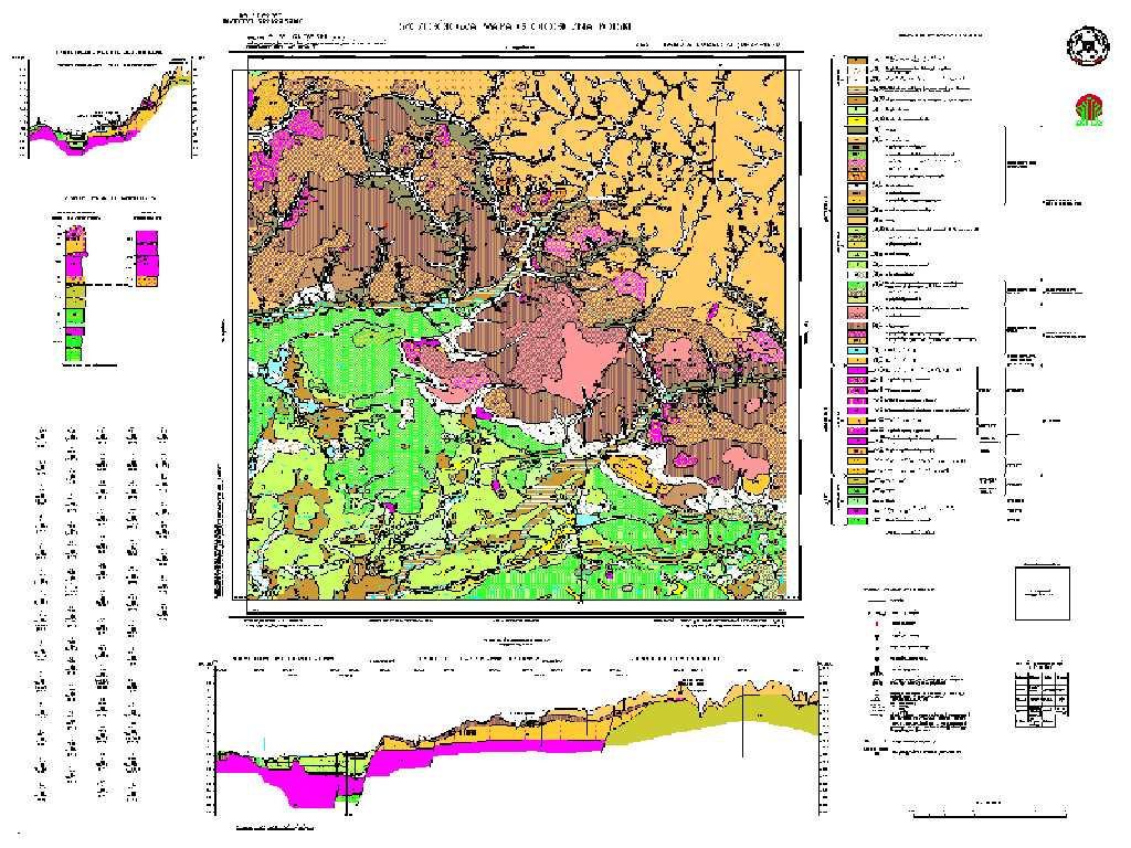 Fig. 7. Janow Lubelski (858)
- The 1:50,000 detailed Geological Map of Poland
Fig. 7. Janow Lubelski (858)
- The 1:50,000 detailed Geological Map of PolandThe computer-aided production of The 1:50,000 Detailed Geological Map of Poland is one of the biggest GIS projects in Poland. It is the only project in Poland concerned with the production of such a large edition of geological maps, consisting of more than 1000 sheets. The degree of complexity of the computer-aided production of the database, data capture, editing and other problems of the maps is adequate for the scale of the research program.
The process of digitising is very quick, but loading of data is a slow procedure, because of the large amount of data and its detailed verification. Accuracy of a source data is the most important factor for the efficiency of the database and computer-aided map edition.
Bielecki T., 1996: Metodyka opracowania obrazow rastrowych dla potrzeb bazy danych Szczegolowej mapy geologicznej Polski w skali 1:50,000, VI Konferencja Naukowo-Techniczna Systemy Informacji Przestrzennej, Warszawa.
Gogolek W., 1995: Database of the 1:50,000 Detailed Geological Map of Poland, Proceedings 17th International Cartographic Confernce, Barcelona.
Gogolek W., Kocyla J., Jurkun A., Zielke J., 1996: Program komputeryzacji Szczegolowej mapy geologicznej Polski w skali 1:50,000, VI Konferencja Naukowo-Techniczna Systemy Informacji Przestrzennej, Warszawa.
Jurkun A., Zielke J., 1995a: Detailed Geological Map of Poland 1:50,000, Proceedings 10th ArcInfo European User Conference, Prague.
Jurkun A., Zielke J., 1995b: Szczegolowa mapa geologiczna Polski 1:50,000 - baza danych oraz wspomaganie redakcji mapy, V Konferencja Naukowo-Techniczna Systemy Informacji Przestrzennej, Warszawa.
Waldemar Gogolek, Tomasz Bielecki, Jacek Kocyla
Polish Geological Institute,
ul. Rakowiecka 4
00-975 Warszawa
Tel. 48 22 495351 (367)
Fax 48 22 495342
e.mail wgog@pgi.waw.pl, tbie@pgi.waw.pl, jkoc@pgi.waw.pl
Aldona Jurkun, Jacek Zielke
Neokart GIS Sp. z o.o.
ul. Batorego 20
02-591 Warszawa
Tel. 48 22 4256482
Fax 48 22 255705
e.mail neokartg@ikp.atm.com.pl