John Maslen, Jonathan Peltenburg and Stephen Atkins
Estuarine environments are under increasing pressure to support a multiplicity of land uses, from urban settlements and their by-products, to recreation and wildlife habitats. Traditional piecemeal management of these areas remains limited and more recent integrated initiatives are attempting to bring diverse organisations together as partnerships.
The inherent nature of the information and the ability to integrate disparate datasets means that GIS is cast in a major role for the management of coastal zone environments. Using a combination of ArcInfo and ArcView, a GIS database has been built for the Moray Firth to look at issues such as habitat suitability and coastal risk assessment. Further considerations of data manipulation, security and dissemination are also raised.
Scottish Natural Heritage (SNH) was established in 1992 from a merger of the Nature Conservancy Council for Scotland and the Countryside Commission for Scotland. It is a government agency which receives virtually all of its funding from the Secretary of State for Scotland. The organisation has 2 key roles: to advise Government and others about the management and use of the natural heritage, and to carry out executive tasks on behalf of the government. Within these broad roles, SNH has a duty to take account of a range of considerations from actual or possible environmental changes, particularly within its designated areas, to the needs of agriculture, fisheries and forestry and the need for social and economic development in Scotland.
The Focus on Firths project was set up in 1993 as part of a Scotland-wide plan to increase the understanding and awareness of the importance of estuaries and coast as natural ecosystems. The aim is to promote integrated coastal zone management (ICZM) through the establishment of voluntary partnerships composed of local interest groups. These range from national organisations like the Scottish Sports Council and the Scottish Environmental Protection Agency (SEPA) to Local Authorities, Enterprise Agencies and pressure groups. In fact, any group or individual with an interest in how these areas are managed can contribute to firth partnerships.
Five partnerships have been established in the last 3 years for the Moray, Cromarty, Forth, Solway and Clyde Firths. Each of the groups are being co-ordinated at the local level by project officers sponsored by SNH and have effectively set their own agendas. The whole Firths initiative continues to be project managed at a national level within SNH to ensure that the benefits of differential rates of development are shared throughout the partnerships. In the future it is intended that SNH will merely become another 'partner' within these autonomous bodies and that they will assume responsibility for setting priorities and decision making. The statutory responsibilities of particular organisations will, of course, remain although it is anticipated that the partnerships would be consulted on most Firth-related matters and would provide a valuable forum for guidance and information.
A major task of each individual firth project is to effectively integrate information in order to inform and develop management policies and strategies. Project managers further need to be able to respond to questions from the forums which have been set up as partnerships of all interests who inhabit, manage or use the coastal and marine areas of the firths. All forum members need a facility to answer queries relating to leisure, recreation or business, in a quick and efficient manner, giving the best quality responses using up to date information. More advanced requirements relate to the analysis and modelling of data to assess interactions and trends of forces changing the ecosystems.
SNH has been committed to GIS technology for 4 years, initially within their cartographic services branch, and more recently as a corporate-wide tool for the management and analysis of data. In the last year, an organisation-wide implementation and training programme for ArcView has been established to decentralise GIS to local area offices and spread the benefits to non-GIS specialists. However, there remains a core team of GIS staff to support these projects using workstation ArcInfo.
At the recent one-day seminar by the Association for Geographic Information (AGI) on this subject the question was raised "What is so unique about GIS applications for the coastal zone?" The following addresses the issues:
1. The land-sea boundary is extremely dynamic. Tides mean that the land area at the coast changes by the hour while the tides themselves vary through the year. In some areas, especially in the firths, the intertidal areas can be extensive (e.g. 4,327 ha for the Dornoch Firth). Secondly due to the physical environment, there can be dramatic changes in the coastline itself through the processes of erosion and accretion over relatively small time frames. Recent front-page media attention focused on the plight of 29 Yorkshire villages which have disappeared into the sea in the last 70 years (The Independent 31 July 1996). GIS applications are now being developed to monitor coastline erosion and accretion (Ligdas 1996, Stileman et al 1996, Dickson 1996) using detailed examinations of historical records. The time dimension must also be incorporated into GIS data models even in the simplest way by recording when the data was collected and how often it is likely to get updated. GIS applications can model cyclical processes such as tidal current movements allowing predictions to be made for the dispersal of pollutants (HR Wallingford 1996) while 'scenario predictions' can be computed as a result of spasmodic events such as storm flooding. Further complexity is inherent in real-time GIS applications which, for example, are required for monitoring oil spill dispersal.
2. There is no definitive map base. Despite experiments by the Ordnance Survey and the Hydrographic Office (Harper and Curtis, 1993), there remains no single source of base mapping and relatively complex cartographic operations are required in order to match up OS maps with Admiralty Charts. The former use the GB National Grid projection while the latter, due to their primary purpose as navigational aids, vary both in terms of projection (Mercator or Gnomonic) and scale. Access to OS digital data is expensive but available in useful digital formats. Access to digital Admiralty Chart data is more difficult. The Hydrographic Office does market the ARCS (Admiralty Raster Chart Service) package but it is produced largely for navigational use and the raw data is encrypted. Other private companies market raster and vector marine data products but these are mainly for small boat users. Licences are available from the Hydrographic Office to digitise their charts in-house.
3. This zone is extremely important in terms of its natural and physical environment. Much of our industry is located along the coast in order to use the water (e.g. power stations) and for transport purposes. Others are dependent on the resources at sea (e.g. oil industry, fishing etc.) In addition 'over one-third of the British population lives in towns and cities around estuaries' (NCC, 1991) while much of our most productive farmland lies in this zone. The coastal zone supports a wide range of unique habitats and species. As a consequence, the pressure on this zone is enormous with a huge potential for conflict in terms of uses.
4. Due to the pressure for space and conflict of interests this area is very difficult to manage. This is exacerbated by a number of factors:
a) In contrast to the land, marine areas have few hard boundaries. This leads to problems of policy enforcement when, for example, defining areas that are important for fish spawning. Also many coastal processes such as sea bed sediment movement will not confine themselves to local administrative management areas. Coastal defences erected by one council or private land owner to protect there own interests can often have a detrimental affect further along the coast. There is now a need to manage this area in terms of natural zones or 'coastal cells' which span several administrative units. Shoreline management plans are now starting to address these issues.
b) Many of the activities in this area span large and sometimes remote areas, for example sea fishing. Thus monitoring and controlling these activities can be extremely difficult.
c) On land, development is largely controlled by the existing tenure system and through planning applications. Although applications for activities such as sludge dumping do need to be submitted, the marine environment lacks equivalent controls for many activities.
5. Traditional 2-D (x,y) co-ordinates are often inappropriate in marine areas for applications such as monitoring sediment accumulation where accurate depth values are crucial. Also much existing marine cartographic work has not limited itself to GIS-compatible points, lines and areas. Often, for example, lines offset from the coast depict a zone to show that canoeing does not take place within 30 metres of the coast. Where polygons have been used as in defining fish nursery areas, hard boundaries are relatively arbitrary and considerable care needs to be taken with interpretation. These examples reflect the difficulties in trying to represent this environment using traditional cartography and in turn representing them within a GIS. New approaches are required, for example tidal information is now often represented using animation techniques (HR Wallingford, 1996).
6. The high cost of carrying out scientific data collection in marine environments is also limiting the development of coastal GIS. The emergence of remote sensing technologies for desktop applications are particularly suited to GIS (Raper et al 1994, Young et al 1996, Groom 1996, Fry 1996) and offer great potential to overcome these problems. However, research by the US Environmental Protection Agency shows that the nature and scale of many of the management issues in coastal areas will continue to require extensive field-based data collection (Copeland et al 1994).
Until recently, GIS applications in coastal and marine environments have been less common and less well defined than similar land based equivalents (Ricketts, 1992). The issues raised above indicate why this may be the case. However, GIS is overcoming these obstacles and increasingly being used to help manage this unique and sensitive zone.
The need for GIS for ICZM of the Scottish Firths became evident after publication of the report: 'The Moray Firth Review' (Harding-Hill, 1993). This report brought together, in paper form, a diverse range of datasets for that area with a view to integrated coastal management. In effect it was a paper-based GIS. Although comprehensive, it lacked flexibility both for analytical operations and updating. A user requirements analysis for a GIS application based on the immediate needs of local SNH Firths officers was undertaken and this highlighted the classic justifications for a GIS approach including the ability to integrate a diverse range of datasets, the need to access and update information easily and produce maps and reports, and the capability to carry out basic spatial analysis. However, as so often in cases where potential users are unaware of GIS functionality, identifying specific requirements for tackling defined tasks was not possible at this early stage. The report did produce a very useful list of generic datasets relevant to coastal zone management (Table 1) which continues to be used as a baseline for data prioritisation and collection.
Table 1: Datasets relevant to coastal zone management.
__________________________________________________________________________________
Physical Environment
__________________________________________________________________________________
Seabed sediments Tidal ranges Solid Geology
Hydrography Geomorphology Bathymetry
Sea Surface Temps Salinity Dune Formations
Rivers Lakes Coastline
Meteorological data Other Chemical Parameters
__________________________________________________________________________________
Natural Environment
__________________________________________________________________________________
Cetaceans Waders and Wildfowl Pinnipeds
Plankton Other mammals (Seals, dolphins etc.)
Invertebrates Seabirds Non commercial fish
Seabird Colonies Littoral and Sublittoral Habitats
__________________________________________________________________________________
Shipping, Navigation and Communication
__________________________________________________________________________________
Capital Dredging Infrastructure Navigation Channels
Services Maintenance Dredging Territorial Limits
Shipping routes Shipping operations Commercial ports
Boat launch sites
__________________________________________________________________________________
Coastal Engineering Works
__________________________________________________________________________________
Breakwaters Flood Barriers Coastal Protection
Tidal Defence Impoundment Structure
__________________________________________________________________________________
Mineral Extraction and Energy Generation
__________________________________________________________________________________
Aggregate dredging Gas Exploration Oil Exploration
Mining Coastal Quarries Undersea cables / pipelines
Oil drilling Coastal power generation
__________________________________________________________________________________
Nature and Landscape Designations
__________________________________________________________________________________
Terrestrial Sites Landscape Sites Intertidal Sites
Geological Sites Marine Sites Amenity Sites
Local distinctiveness Landscape assessment Aesthetic Value
Cultural / Historical sites Sea Wrecks
__________________________________________________________________________________
Waste Disposal and Effluent Discharge
__________________________________________________________________________________
Spoil Disposal Pollution Incidents Sewage Disposal
Agricultural Effluent Industrial Effluent Litter
Discharge Sites Water intake sites
__________________________________________________________________________________
Coastal Industry and Settlement
__________________________________________________________________________________
Land Claim Dockyards Urban Development
Marinas Local Communities Industrial Development
Ports and Harbours
__________________________________________________________________________________
Military Use
__________________________________________________________________________________
Ammunition Storage Exercise Areas
__________________________________________________________________________________
Fisheries and Aquaculture
__________________________________________________________________________________
Sea Fishing Fish Spawning and Nursery Grounds
Salmonid Fishing Eel Netting Fish Farming
Bait Digging Shellfish Farming Shellfish Collection
__________________________________________________________________________________
Recreation
__________________________________________________________________________________
Power Boating Walking Jet Skiing
Nature Watching Water Skiing Wildfowling
Sailing Swimming Windsurfing
Access Mooring/Anchoring Camping
Sub Aqua Horse Riding Rowing
Motor Cycling Canoeing Cycling
Angling Beach activities Gliding
Golf Motorcycling / 4WD Yacht clubs
__________________________________________________________________________________
Access
__________________________________________________________________________________
Car Parks Roads Routes to shoreline
Footpaths Railways Cyclepaths
Airports Helicopter landing sites
__________________________________________________________________________________
Contextual Data
__________________________________________________________________________________
Backdrop data e.g. OS maps, Admiralty charts Land use
Lat/Long graticule Telephones Property ownership
Development of the Firths GIS started in March 1996 as a one year research project. Due to data licensing and the relative infancy of the Firth Partnerships as organisational bodies, it was not intended that the system would be used outside SNH. However, it was intended to demonstrate real benefits of integrated coastal zone management to the Partnerships and hoped that in the longer-term, the Partnerships will become largely autonomous.
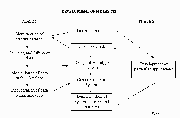
The project incorporated 2 main phases:
1. The sourcing and manipulation of datasets which were identified by the users as being of primary importance in order to produce a comprehensive inventory. Development of a prototype application was carried out in ArcView based on the immediate requirements of SNH staff.
2. Development of specific applications to address more significant
management issues that SNH staff and Partnership members had identified.
Figure 1. Development of Firths GIS
As Figure 1 illustrates, the prototype is continually being refined throughout these phases with the addition of new data sources. Likewise, both phases incorporated user feedback from GIS experts on design issues and GIS novices on requirements specific to their jobs. A series of demonstrations for both SNH staff and Firths Partners were carried out and proved useful forums for developing ideas and promoting potential benefits. Every attempt has been made to ensure that development is user-driven rather than technology-driven although it is inevitable that, where the GIS knowledge base is low and user requirements are vague, technical progress is vital to stimulate feedback. The importance of software development taking place on-site for such an approach cannot be over-estimated. Discussion with a wide variety of coastal and marine specialists has been highly beneficial and a thorough awareness of coastal management issues has been a critical factor in pre-empting software applications.
The collation of good quality datasets from a large range of organisations is proving extremely time consuming and will continue throughout the project. The data collected is in a wide range of formats from paper documents and maps to photographs and numerous digital data formats. Much work has been involved in sifting through this data to retrieve relevant information. ArcInfo has been used to manipulate and convert much of the data into a suitable form for use within the Firths system.
Data forms have been sent to data suppliers to ensure that as much metadata can be made available to potential users of the system. However, in several cases, basic information regarding the data currency and accuracy has simply never been recorded. The purpose of data collection has often been for very specific projects calling into question its wider usage. This, together with the large number of different standards within public agencies for collecting the same type of data, has led to a proliferation of data 'themes'. For example, it would be difficult to compare outfall discharges within a single Firth as each local authority uses a different classification system.
Information has now been supplied from a large number of external public, private and voluntary organisations. These include the Scottish Office Marine Laboratory, the Scottish Environmental Protection Agency, the Scottish Institute of Maritime Studies, the Scottish Sports Council, various local authorities, British Geological Survey, Joint Nature Conservancy Council, Macaulay Land Use Research Institute, RSPB, British Trust for Ornithology, Wildfowl and Wetlands Trust, Norwich Union Coastwatch UK, Historic Scotland and the Royal Commission on Ancient and Historic Monuments. SNH has data licence agreements with the OS, Automobile Association and Hydrographic Office and also a comprehensive library of aerial photographs and satellite imagery.
Having standardised the datasets within ArcInfo the data can be passed to ArcView and organised within this system. GIS systems for coastal zone management can be highly complex and require a great deal of computer expertise to use them. There is an 'urgent need to provide simpler access and data manipulation tools that can be used directly and relatively easily by the resource managers and scientists' themselves (Ricketts, 1992). Hence the Firths system has been developed solely within the ArcView environment using Avenue.
The interface has been customised to meet the requirements of 3 main levels, the novice, the intermediate and the advanced user (as shown in figure 2). As the user becomes more confident the number of buttons, tools and menu options increases. The novice level assumes virtually no prior knowledge of ArcView. This system can be used for viewing data (as a set of predefined views) and giving the user an idea of the kind of datasets that are held. This alone allows the user to gain a greater awareness of the area they are interested in.
Figure 2. Advanced user interface
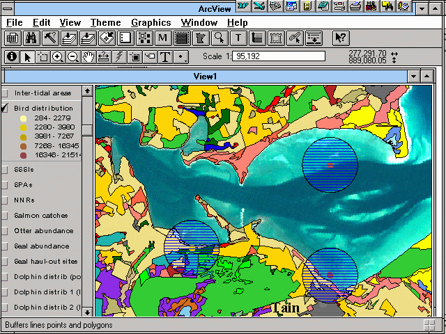
The intermediate system still requires little knowledge of ArcView and again appears relatively simple. Users can chose which datasets they view and begin to start querying and looking at interactions between various data sets. Tools are available for: adding themes (from a list) to the view, measuring distances and areas of particular features in the view (e.g. distance of a particular length of coastline), moving around the area of interest easily (gazetteer type functions e.g. zooming in to a particular SSSI and index screen ), buffering features (e.g. creating a zone of influence for a particular sewage outfall), displaying metadata, producing reports, and producing standardised maps. Most of these functions involve simply pushing one button and therefore avoid the user needing to have detailed knowledge of the system. Tools also exist to help officers answer queries such as 'What's the total intertidal area within a particular SSSI'.
The advanced interface includes all the customised functions and most of the standard ArcView buttons and tools. This interface allows the user to further customise the system to their own needs and carry out further analysis. It is envisaged that as users become more familiar with the system they will end up using this interface for most of their work.
The project is now building on the basic functionality and inventory objectives of Phase 1 and focusing on the development of specific applications. A number of reports have been produced by the Firths Partnerships detailing specific management issues to tackle. In many cases, they relate to spatial marine and land use conflicts. These can be as specific as windsurfers 'spooking' horses in a particular bay or as general as the need to consider the implications on development of further nature conservation designations. They have categorised these issues under headings listed in Appendix A (Solway Draft Issues Paper 1996). A large proportion of this information is spatially referenced. GIS can, in many cases for the first time, explore the relationships between different coastal resources and, through planning and zoning initiatives, seek to minimise conflicts between stakeholders.
One particular issue of relevance to both SNH and the Partnerships is that of contingency planning for the potential impact of oil spills. In the Firth of Forth, for example, there is a large volume of oil related traffic with 3 different oil companies having interests within the estuary. Each oil company is legally required to have its own contingency plan for each of its operations although these tend to be in the form of paper maps detailing information such as the type of coastline, local landowners, access points, boat launching sites, and a range of environmental information. The maps are able to provide an impression of coastal sensitivity and assist in shoreline clean-up operations. As suggested in several recent reports (Gundlach et al 1991, Baker 1993, Ireland 1994, Krishnan 1995, Green 1996), GIS is ideally suited to provide up-to-date, accurate information of this sort and relatively simple buffering techniques could be used to identify those areas at the time of the spill that were most at risk. They would also be able to incorporate a greater range of datasets such as cultural and recreational information. Relatively sophisticated scoring techniques are now being developed and incorporated within a GIS to characterise the coastline and co-ordinate response priorities (Owens 1994).
The building of partnerships composed of a diverse range of coastal zone interest groups is seen by SNH as the most appropriate way forward to address the integrated management needs of the Firths. In GIS terms, this raises a number of complex issues relating to the organisational setting of the technology and the sharing of the data.
Primarily, for GIS projects to be successful they require relatively long-term financial commitments. It could be a costly mistake to include a water intake site in a coastal sensitivity analysis when it was shut down the previous year! GIS projects of this nature may also differ in terms of running costs. It would be expected that these would stabilise at a significantly lower level once the system had been 'run-in'. However, where datasets in different formats and subject to different standards are being shared, this may incur continuing development costs and require the experience of a GIS professional. Unquestionably, GIS projects, like any other large IT projects, cannot be seen as short-term investments that will meet requirements for the coming years.
The legal alternatives for establishing a partnership include setting up a limited liability company, creating a looser unincorporated association or establishing an information sharing network. Each has its own benefits and drawbacks although a major difficulty with the former option is that Local Authorities may be prohibited by statute from entering limited companies. The most likely preference for partnerships still in their infancy is the most decentralised option of an information sharing network. The advantages of a looser organisational structure are likely to generate more serious problems regarding data access and licence agreements. Some of these, particularly for datasets owned by the partners, can be eased by establishing an agreement for the purpose of handling the intellectual property rights brought in or created by the forum. However, the partnership is still likely to be seen as a third party or collection of third parties by a data source who has supplied datasets to a specific partner.
Legal structures are not the only inhibitors to data sharing. Green (1996) argues that the availability and application of data depended largely on technical aspects such as data standards, accuracy, documentation, format, costs, copyright and lack of metadata catalogues. In addition to these factors, a number of other barriers are also prevalent:
For GIS to assist in integrated coastal zone management, it requires current, accurate data from a large range of sources. In the case of a partnership, without the incentive of sharing these benefits among the data providers it is difficult to see how these barriers to data sharing will be overcome. The challenge is to find technical alternatives and organisational structures which will allow GIS to flourish. The establishment of standard data exchange formats which do not require additional expensive translators would certainly be a step in the right direction, as would the development of data quality protocols particularly for metadata standards. Technical solutions must be found to enable users to interrogate databases over a network without breaching licence agreements and copyright laws. Research is currently underway to develop an Internet site for the Firth of Forth to provide basic mapping and statistical information (Green 1995). Finally, licence agreements issued by private, public and voluntary organisations should be sufficiently flexible and affordable to deal with partnerships of this kind.
The nature of the user base has meant that the approach adopted for this project has been as much about promoting the benefits of the technology as it has about developing the system itself. The development of a prototype for a specific area has been crucial both in stimulating feedback and generating support. On-site development and encouragement from SNH staff have likewise been critical.
It is clear that relatively simple desktop GIS tools can provide an intuitive environment for facilitating integrated management. It remains to be seen whether it is possible to set up an organisational framework within which such tools can operate successfully.
Stephen Ray (Aberdeen University) for provision of data and information for Moray Firth.
1. Access
2. Agriculture
3. Awareness, interpretation and education
4. Beach cleanliness
5. Cultural heritage and archaeology
6. Development
7. Exploitation of non-living resources
8. Flood defence and coast protection
9. Landscape
10. Local economy
11. Nature conservation
12. Recreation
13. Salmon and trout fishing
14. Sea fishing
15. Tourism
16. Waste disposal and recycling
17. Water quality
18. Potential future issues
Baker, P. (1993). Development of an environmental sensitivity atlas for Lake Superior's Canadian shoreline using electronic desktop mapping. Proc. of the 16th Arctic and marine oil spill program technical seminar. pp 225-255.
Copeland, J., Smith, C., Hale, S., August, P. Latimer, R. (1994). EPA program monitors US coastal Environments. GIS World, Aug. 1994 pp 44-77.
Esri ARC News (Summer 1996). Using Technology to manage a shoreline.
Fry, C., (1996). A new coastguard for the UK. GIS Europe, August 1996, pp.36-38.
Green, D.R., (1994). Using GIS to construct and update an estuary information system. Proc. of management technology in the coastal zone. Centre for coastal zone management. Univ. of Portsmouth, October 1994 pp.129-162.
Green, D.R., (1995) Internet and WWW browsers: the basis for a network-based GIS for coastal zone management. Proc. of AGI '95, Birmingham, UK pp5.1.1 - 5.1.12.
Green, D.R., (1996) Between the desktop and the deep blue sea. Mapping Awareness, July 1996, pp 19-22.
Groom, S., (1996). The NERC remote sensing data analysis service. NERC News, summer 1996, pp 28-29
Gundlach, E.R., Little, E.D., (1993). A portable GIS for spill response planning. Proc. of the 16th Arctic and marine oil spill program technical seminar. pp 541-551.
Harper, B, Curtis, M.(1993). Coastal Zone Mapping. Mapping Awareness and GIS Europe Vol. 7 Jan/Feb, 1993 pp 17-19.
HR Wallingford (1996) Modelling pollution dispersal in the Firth of Tay. Personal communication.
Ireland, P.(1994). Mapping out a slick Response. Mapping Awareness, May 1994 pp 30-33.
Koh, A, Edwards, E. (1996). Integrating GPS data with fly on demand digital imagery for coastal zone management. Papers of AGI Managing the UK Marine & Coastal Environment special interest group, Manchester, July 1996.
Krishnam, P.(1995). Research Report - A GIS for oil spill sensitivity mapping in the Shetland Isles. Ocean and coastal management Vol. 26 (3) pp 247-255.
Ligdas, N. (1996). A GIS application for the study of coastal processes in the NE of England. Papers of AGI Managing the UK Marine & Coastal Environment special interest group, Manchester, July 1996.
Nature Conservancy Council (1991). Nature conservation and estuaries in GB.
Owens, E.H.(1994). Canadian coastal environments, shoreline processes and oil spill cleanup. Environment Canada - Environmental protection series 3/88/5, March 1994
Raper, J., McCarthy, T. (1994). Using Aerial videography to access coastal evolution hazards. Proc. European GIS conference '94, Paris, France. pp.1224-1228.
Ricketts, P.J. (1992). Current approaches in GIS for coastal management. Marine Pollution Bulletin, Canada, Vol 25 1-4 pp.82-87.
Roper, C. (1994). Hydrographic Office bids for world market admiralty raster chart service (ARCS). Mapping Awareness, June, 1994. Pp 36-38.
Solway Firth Draft Issues Paper.(1996). Unpublished
Stileman, M., Home, R. (1996). Applied GIS with shoreline management. Papers of AGI Managing the UK Marine & Coastal Environment special interest group, Manchester, July 1996.
Young, B. Knight, R.(1996). Baseline monitoring of habitat in Murlough and Dundrum bay area. Papers of AGI Managing the UK Marine & Coastal Environment special interest group, Manchester, July 1996.
John Maslen & Jonathan Peltenburg
GIS Analyst/Programmers
Geographic Data Support
11 Fir Tree Close
Flitwick
Bedford
MK45 1NY
Telephone: (01525) 717967
Stephen Atkins
Firths Project Manager
Scottish Natural Heritage
2 Anderson Place
Edinburgh
EH6 5NP
Telephone: (0131) 4474784
Fax: (0131) 4462405
email: eab@rasdsnh.demon.co.uk