Andrew Sparkes and David Kidner
Planning applications for environmentally sensitive developments must be accompanied by an Environmental Statement (ES) which addresses public concerns over the likely impacts on the landscape. This paper describes a project which was undertaken to perform the spatial analysis required for an ES of a proposed wind farm. The system, developed within ArcInfo, integrates a variety of data sets (including digital terrain models, topography, aerial photographs, census data and even individual buildings) to quantify and qualify these environmental impacts. This paper also describes how the system was extended to consider site selection criteria to determine the optimal locations for wind farms.
Concerns about the impacts that traditional power generating methods have on the environment have led many to believe that a radical rethink is now needed as to how our energy of the future is generated. These concerns have caused an increased interest in so called 'environmentally friendly' renewable energy sources. These cover sources that occur naturally and repeatedly in the environment, such as energy from the sun, the wind, the oceans, the Earth, waste, and the fall of water. Today, these account for over 20% of the world's electricity production. The European Commission (EC) and individual countries such as Britain, have programmes which aim to stimulate the development of renewable energy technologies to the fullest practical extent, where they have prospects of being economically attractive and environmentally acceptable. In Britain, such technologies were given a major boost resulting from the privatisation of the UK's electricity industry. As part of the 1989 Electricity Act, generators of electricity from fossil fuels are obliged to pay a toll which in turn is distributed to non-fossil fuel electricity generators. This scheme is called the Non-Fossil Fuel Obligation (NFFO) and is set to operate until 1998.
Over the past years, these factors have led to an increased number of renewable energy developments. Wind power is one such form of renewable energy which is on the verge of widespread commercial exploitation. In the right conditions, wind energy can now produce cheaper electricity than either coal or nuclear power stations, and an equivalent return to gas-fired power stations. One such condition is an average wind speed of 7.5 metres per second, which according to studies by the EC suggests that there are as many as 400,000 sites which have the potential to be economically viable as wind farms in Europe (Lindley & Swift-Hook, 1989). As of the end of 1995, Europe had 2311 MW of installed capacity, compared to 1870 MW in the U.S. Much of this has come from the large German programme, but countries such as France and Spain are rapidly increasing their wind energy developments.
In Britain wind power in particular has enjoyed a large growth, with a target of 1500 MW by the year 2000. However, although wind power may currently be seen as the most viable way of generating clean renewable electricity in this country, the belief that it is entirely 'pollution free' is a misconception (Manning, 1983). Wind power may not produce any physical pollution, but its impact on the local environment includes visual and noise intrusion, electromagnetic interference and possibly wildlife collisions. The result is that people's attitudes towards wind power developments may sometimes change, from being favourable in principle to being opposed, when faced with the prospect of having a wind farm in their local vicinity.
As with any other proposed environmentally sensitive development an Environmental Statement (ES) has to form part of the planning application. Its purpose is to give both the planning authorities and the local residents an idea as to the likely effect the wind farm will have on the local environment. The ES includes all of the relevant information about the development, the analysis of the data obtained and a statement of the project's possible and probable impacts on the environment (Kidner et al, 1996). This will include an analysis of the visual impact via the determination of areas from which the development can be wholly or partially seen, i.e. viewsheds or intervisibility maps. This information is normally shown on a two dimensional map, centred on the location of the proposed wind farm.
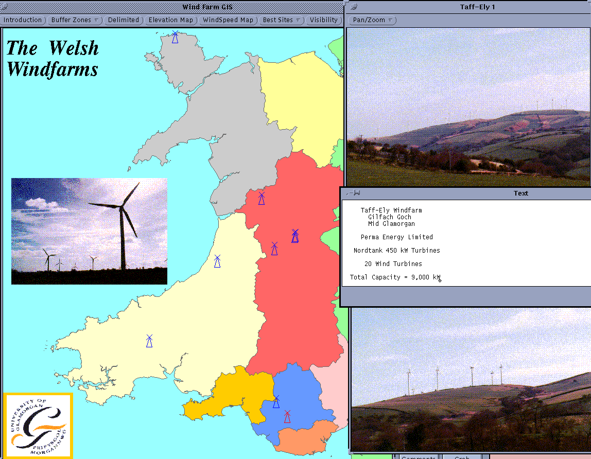
The purpose of this study was to develop a GIS which can not only determine the visual impact of a wind farm, but can visualise these results in a meaningful way, specifically as part of a more general wind farm information system (Figure 1). The functionality required of the system ranges from calculating intervisibility to categorising the landscape and determining the number of households within the viewshed of a proposed development. GIS site selection algorithms have also been developed to determine the optimum locations for wind farms and even the positions of individual turbines which minimise visual impact and development costs, or maximise the resource potential.
Figure 1 - The University of Glamorgan Wind Farm GIS.
(Click on Image or Figure Caption for Full Resolution Image)
One of the main aims of the ES is to aid the public's understanding of the likely visual intrusion of the proposed wind farm. This necessitates the use of visual techniques that are both easy to understand, and yet portray relevant information. Two visual techniques which are commonly used for this purpose are photomontages and intervisibility maps.
Photomontages are produced by an artist who begins with a photograph from a location of known distance and bearing, that looks towards the proposed development site. Using this information, the size of the turbines are calculated in relation to the distance. Accurate scale drawings of those turbines which will be visible from that location are then imposed onto the photograph.
Photomontages provide a very accurate idea of how a new development will look from a particular location. Because the public are used to looking at photographs, the image is quickly understood and leaves little room for misinterpretation. Unfortunately photomontages are not cheap to produce, requiring skilled personnel and a considerable amount of time. By definition each picture can only ever deal with the view from one location and so are fundamentally inflexible, requiring a complete recalculation if the observation point were to change.
The capabilities of conventional GIS for providing this type of visualisation are very limited. Some GIS do cater for extensions of existing CAD facilities (eg. ArcInfo and AutoCAD). In most cases though, realistically rendered 3-D visualisations of objects on a landscape are not customary. Some software packages exist, which allow the user to input photographs and viewing information for automatically generating photomontages. In the case of the Danish system "VISUAL", a library of wind turbine generators (WTGs) is available to the user. Coordinates are entered, and the resulting photomontage of the wind farm is produced. Figure 2 illustrates the concept of a photomontage, and a CAD representation of the development.
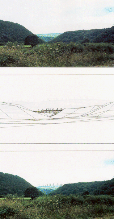
Figure 2 - Photomontage and CAD Representation of a Proposed Wind Farm.
Photomontages can also give a pessimistic impression of the development mainly due to the way that they are created. In order for the turbines to be visible on the photograph they tend to be painted in white or given a black outline; resulting in them having a high degree of contrast. Thus the turbines standout more than perhaps they would in reality where weather conditions, angle of the sun, etc., would result in the turbines not being as prominent on the landscape.
Another important attribute where photomontages fail, is their inability to depict movement. A moving object on a landscape, in this case the rotating blades, attracts far greater attention than a static object. Not only this, but often on a bright day, reflection from the rotating blades can produce an effect not unlike a torch constantly being flashed on and off. Clearly, these factors are impossible to implement on a 'still' picture and yet the public should still be made aware of their existence. There have been however, attempts to produce videomontages of wind farm developments, but these have been largely unsuccessful and very costly to date. Alternative approaches favour the use of advanced computer aided design packages, which allow for 'fly-bys' of the proposed working wind farm.
An intervisibility map, viewshed or ZVI (Zone of Visual Intrusion) is normally represented by a two dimensional map, centred on the location of the wind farm. Its aim is to show from which areas the development is likely to be visible. The region of interest for which these ZVIs are calculated, may be up to a radius of 20 km from the centre of the development. This gives the observer a general idea of the visual impact on the wider surrounding area (Figure 3).
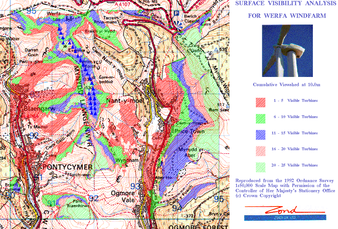
Figure 3 - ZVIs for a Proposed Wind Farm of 25 Turbines at Werfa in South Wales.
As an alternative, the viewshed information can be portrayed on an aerial photograph, registered to the same coordinate positions of the digital elevation model. At large scales, individual buildings which lie within the ZVIs can be identified. Of the two techniques, intervisibility maps are the harder to interpret, as they are less intuitive than a photomontage and the public are less familiar with them. Therefore it is important that when used, careful thought is given as to how best to relay the viewshed information.
A consideration when producing each intervisibility map is the 'banding' or cumulative viewshed of the turbines. A viewshed of a wind farm development must show more than just whether a location can see a wind turbine or not, rather it must show how many turbines are visible. This information could be represented by shading each location with a single colour for each number of visible turbines, e.g. blue donates that three turbines are visible from position x etc. The problem with this method is that if the number of turbines exceeds seven or maybe eight, the viewshed information contained therein becomes unreadable.
A solution to this problem is to 'band' turbines together. For example, as in Figure 3, five colour bands are used. The first denotes that one to five turbines are visible; the second band, six to ten and so on. This has the advantage of making the viewshed far easier to understand as the amount of information being presented is more manageable. However banding does result in a loss of information. Within the viewshed area of a given band, the precise number of visible turbines, and which ones are visible, is unknown. It is therefore important to get the banding ratio correct - large bands may lead to a loss of information, whilst small bands may have the opposite effect by displaying too much information. If a location does lie within a viewshed polygon and the exact number of visible turbines is required, then a menu option exists that allows the user to specify the location with the mouse in order to find out.
Another issue that must be addressed when presenting viewsheds is the use of colour when displaying the individual viewshed 'bands'. Usually, bright colours that contrast highly with each other are used, because they allow for the easy identification of individual visible areas. However, this may not always be the best method, as a map covered in a mass of bright colours is likely to give the observer an overly pessimistic impression of the visual impact of the wind farm. An alternative might be to use a more subtle range, perhaps using different shades of the same colour. Obviously people's perception and response to colour varies from individual to individual.
With these issues in mind the system has been designed for flexibility, by allowing the developer the ability to experiment by altering a number of parameters that dictate how the final viewshed is displayed. Firstly the system incorporates a function that allows the user to choose how turbines are banded together. The user is prompted to enter a comma separated list detailing the bands required. Once the bands have been entered, the system asks the user to assign a colour to each one. The way colours are selected can be done in one of three ways. Firstly the user can choose a pre-defined colour range. Four ranges are available, each based on a primary colour; with each range starting from a light shade and getting progressively darker. Secondly, colours can be picked by entering the shadeset's respective palette number. Lastly, colours can be selected from a pop-up menu using the mouse. Thus the ability to define the banding of turbines and their respective colour gives the wind farm developer a wider choice as to how the information about the visual impact of the farm is presented.
Viewsheds are a useful means of displaying visual impact. However, it is often difficult for the observer, if untrained or unused to reading maps, to understand exactly what is being shown and to relate the pictorial representation to known locations and features in the landscape. An alternative is to drape the viewshed over a 2.5D map of the area. The system allows this, and like the normal 2D viewshed, gives the user a choice as to what layers are displayed. Figure 4 shows an example of the output produced by the GIS. Although the amount of information shown is limited (only roads & buildings), by showing the form of the land, the image is likely to be easier understood and identified as representing the local environment. When displaying a 2.5D image the user can choose between a pre-defined isometric projection, or specify their own. The latter is achieved by the user specifying an observer and target position with the mouse, along with their respective heights. It is also possible to zoom in on any location, if the area depicted is thought to be too large.
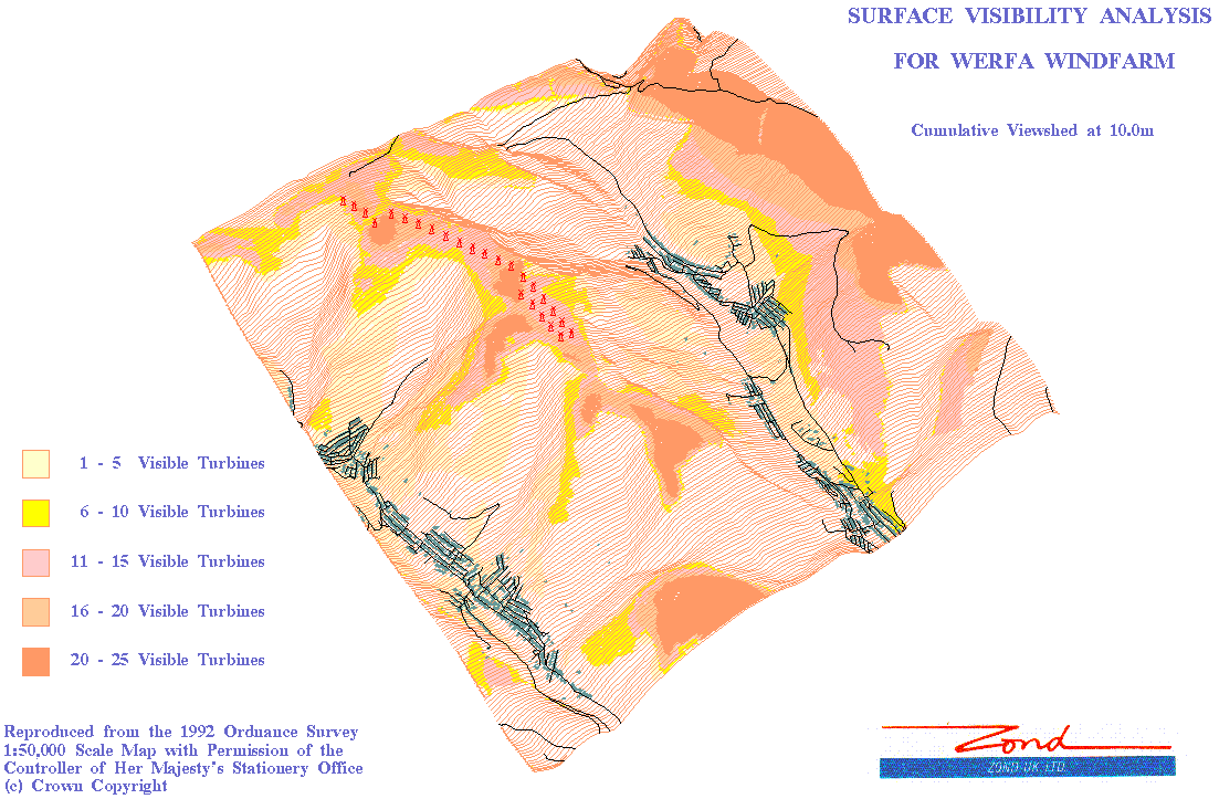
Figure 4 - 2.5D ZVIs for a Proposed Wind Farm of 25 Turbines at Werfa in South Wales.
Rather than draping the ZVI polygons onto a wire-frame of the DEM, results can be easily presented with other surfaces. For example, options exist for draping ZVIs on hill-shaded surfaces, aerial photographs, land-class maps, or a colour-coded Census map of Enumeration Districts. Additional software modules allow for more detailed analysis of demographic information. For example, for each building, Address Point, Post Code, or user-selected location, individual line-of-sight (LOS) profiles are calculated to each WTG. A breakdown is given of which WTGs are visible, and if so, how much of each WTG can be seen. Alternatively, the impact of each WTG can be quantified in terms of the population or number of buildings within its viewshed.
In all visibility calculations, the DEM is integrated with other surface features which are likely to cause obstructions. In most cases this requires additional large-scale data, via digitising of suitable maps. Typically, this includes all forestry and woodland, together with buildings.
As well as producing viewsheds the system also incorporates an option for site selection. There are many criteria that can be used as determinants for selecting sites that may be suitable for a new wind farm development. The relative importance of each is very dependent upon the viewpoint of the user, ie. environmentalist, conservationist or developer. However, if the criteria themselves are subjective, then the limits associated with each are even more so. For example, it may be obvious that a wind farm should not be too close to an airport, but what distance should the exclusion or buffer zone be - 1 km, 3 km, ...? Rand & Clarke (1990) and the British Wind Energy Association (1994) have summarised the environmental impacts of wind farms and suggest separation distances to minimise the impact on a number of land uses. However, not all criteria can easily be catered for, since the local environment may determine criteria which are specific to a particular area or country even (Kidner, 1996).
The GIS has been designed to be as flexible as possible, allowing the user to specify which criteria will be used for the site selection, and if included what buffer distance to use around each excluded feature. The system then generates a macro of ArcInfo commands which determine all the sites that meet these criteria. For this project, the geographic area used is the whole of Wales, whilst the data sets used for the initial selection were the Bartholomew's 1:250,000 scale digital map library.
A typical query asked of the GIS might be to find all the sites in Wales that meet the following criteria:
Are not within 3 km of an airport;
Are not within 1 km of a National Park;
Are not within 1 km of a National Trust property;
Are not within 3 km of a military danger zone;
Are not within 1 km of a Scenic Area;
Are not within 1 km of a Forest Park;
Are not within 2 km of a built-up area;
Are not within 5 km of a city centroid;
Are not within 2.5 km of an urban centroid;
Are not within 1.5 km of a town centroid;
Are not within 1 km of a small town or village centroid;
Are not within 750 metres of a small village, hamlet or isolated
settlement;
Are not within 250 metres of a lake, marsh or reservoir;
Are not within 300 metres of a motorway, A-road or B-road;
Are not within 250 metres of a railway;
Are not within 200 metres of a river or canal;
Are not within 250 metres of a radio or TV mast;
Are above 100 metres in elevation (Using the premise that wind
speeds are generally greater in higher terrain, whilst the main
population centres and tourist areas tend to be located within
the coastal plains of Wales);
Are not within 1 km of a 'picturesque' or scenic feature, including:
Battlefields, Castles, Country Parks, Historic Sites, Houses or
Gardens, Nature Reserves or Scenic Viewpoints.
(These criteria and buffer distances are hypothetical and are
only used for illustrative purposes.)
For example, Figures 5 and 6 illustrate the exclusion zones generated by this query for roads and National Parks respectively.
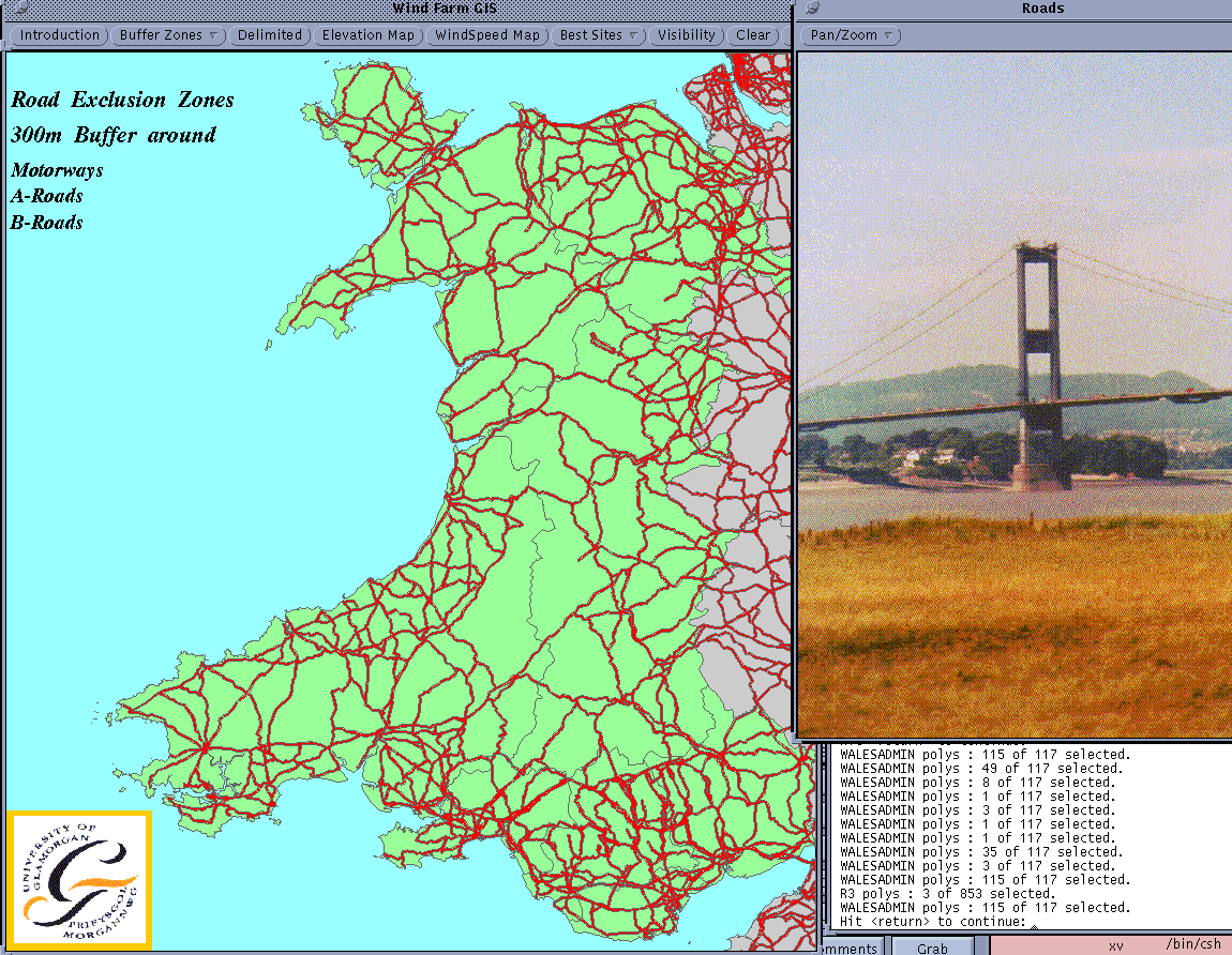
Figure 5 - Main Road Exclusion Zones for Wind Farm Site Selection Algorithm.
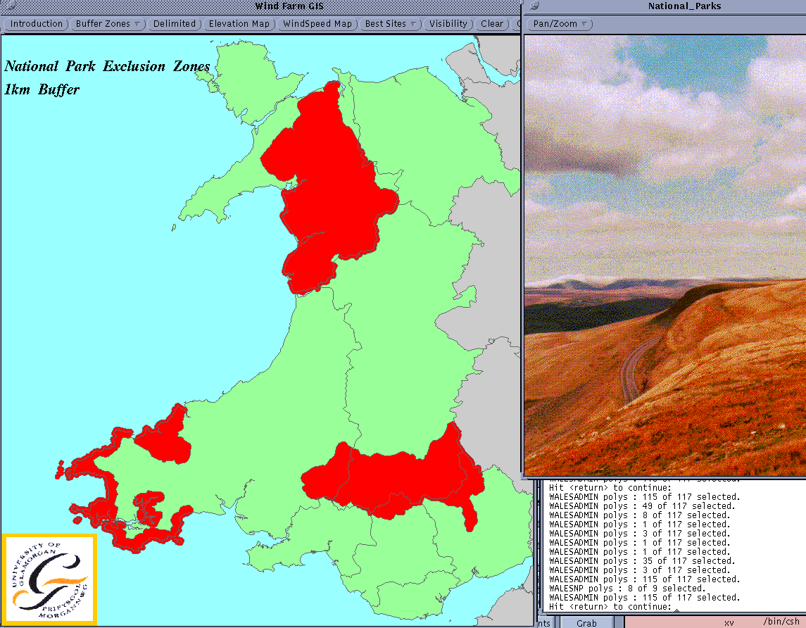
Figure 6 - National Park Exclusion Zones for Wind Farm Site Selection Algorithm.
For most of the exclusion factors, the specified distance buffers are generated around the features to create a number of new polygonal coverages. The areas within the polygons are then taken in turn to 'cut' the coverage representing the study area, i.e. Wales. The result is a number of 'good' sites that satisfy the requirements for our proposed wind farm. However, although these areas fulfil the specified criteria, the size of these 'pockets' will often be too small to cope with anything more than one or two turbines. Hence the user is given the option to enter a minimum size for any potential sites. Figures 7 and 8 show the results for the above query, with and without constraints imposed on the size of the selected sites.
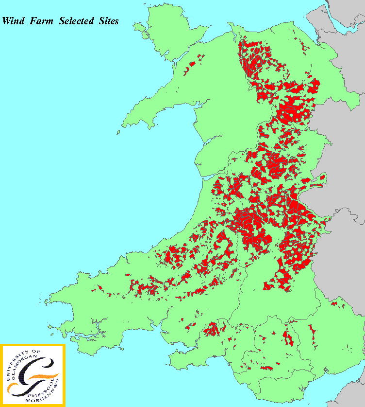
Figure 7 - Suitable Wind Farm Sites (No Size Constraints).
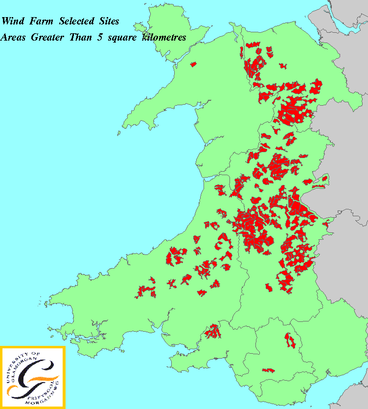
Figure 8 - Suitable Wind Farm Sites (Size > 5 square kilometres).
GIS can be used as a valuable tool by wind farm developers for selecting suitable sites and for performing the necessary visibility analysis. For both of these applications, systems have been developed within ArcInfo which illustrate the potential of such visualisation and analytical tools. However, in both areas, GIS is still in its infancy, with respect to producing optimal solutions. GIS can give us the results and information we require of it, but with a greater understanding of the issues involved we can soon appreciate how GIS can revolutionise these current basic approaches. One way forward is the development of better spatial decision support systems, which can be easily integrated with systems such as ArcInfo.
The authors would like to acknowledge the support and advice given to them by National Wind Power during the course of this research.
British Wind Energy Association, "Best Practice Guidelines
for Wind Energy Development, ISBN 1-870064-21-6, 1994, 24 pages.
Kidner, D.B. & M.I. Dorey, "Visual Landscape Assessment
of Wind Farms Using a Geographical Information System", in
Wind Energy Conversion 1995, (Editor: J. Halliday), MEP, London,
1995, pp. 182-189.
Kidner, D. B., M.I. Dorey & A.J. Sparkes, "GIS and Visual
Impact Assessment for Landscape Planning", Proceedings of
GIS Research in the UK (GISRUK'96), University of Kent, 1996,
pp. 89-95.
Kidner, D.B., "Site Selection and Visibility Analysis For
a Wind Farm Development: A Problem for GIS?", Proceedings
of the 1st International Conference on GIS in Urban, Regional
and Environmental Planning, Samos, Greece, April 19th-21st, 1996,
pp. 220-237.
Lindley, D. & D.T. Swift-Hook, "The Technical and Economic
Status of Wind Energy", in Wind Energy and the Environment,
(Editor: D.T. Swift-Hook), Peter Peregrinus, London, 1989, pp.
1-5. Manning, P.T., "The Environmental Impact of the Use
of Large Wind Turbines", Wind Engineering, 1983, Vol. 7,
No. 1, pp. 1-11.
Rand, M. & A. Clarke, "The Environmental and Community
Impacts of Wind Energy in the UK", Wind Engineering, 1990,
Vol. 14, No. 5, pp. 319-330.
Andrew Sparkes & David Kidner
Department of Computer Studies
University of Glamorgan
Pontypridd
Rhondda Cynon Taff
CF37 1DL
Telephone: 44-(0)1443-482647
Fax: 44-(0)1443-482715
email: dbkidner@glam.ac.uk or ajsparke@glam.ac.uk