 Version francaise
Christophe Durand, Brigitte Guillaumont, Jean Prou
Patelle uses ArcView as a graphic editor to describe, tune and activate GIS processing chains needed by management and planning GIS projects. Each step of a chain is visualized in a view where parameters appear as graphic objects. Patelle offers a set of pre-defined process templates which can be combined into a chain. These include frequently used operations based on ArcView, ArcInfo, ERDAS Imagine, DOS or UNIX commands as well as custom templates added by advanced users.
The graphical metaphor hides the complexity of the commands involved as well as the location of the machine on which processing is performed. It provides ArcView users with a uniform and simple access to tested and on-line documented processing capabilities.
Two marine environment projects have demonstrated Patelle's capacity to enlarge the community of GIS users in our oceanographic research centre.
The results of GIS projects are often produced by combining georeferenced data coverages. The tuning and activation of a GIS processing chain generally require use of complex software tools (vector processing, image processing, UNIX or DOS commands, etc.)
PATELLE (Prototype pour l'Aménagement du Territoire en Environnement Littoral), developed under ArcView, offers to GIS users a simple access to the functions needed to produce a GIS project result.
This paper introduces Patelle's objectives and main functionality. It also briefly describes how Patelle can be used and how it was designed and implemented.
It was written for thematicians who might use Patelle to create, tune and activate GIS processing chains and for managers and planners who may use it as a tool for their decision process. Knowledge of ArcView, although not mandatory, is recommended in order to take advantage of the information contained in this paper.
Patelle originated from the need of the Sillage group and its partners within IFREMER.
IFREMER (Institut Français de Recherche pour l'Exploitation de la MER - The French Institute of Research and Exploitation of the Sea) is a French government research agency, established in 1984. It is a public establishment, partly funded by the state carrying out academic, industrial and commercial activities involving 1200 engineers, researchers, technicians and administrators worldwide in about 30 different locations. The IFREMER annual budget is almost 1 billion FF.
The Sillage group (Systèmes d'Informations LocaLisées pour l'Aménagement et la Gestion des Espaces côtiers et marins), was created in 94 at IFREMER Brest. Sillage's main objective is to demonstrate the interest of geographical information systems (GIS), remote sensing, and image processing for the management and the control of the coastal zone.
The development of a GIS project often involves the cooperation of various thematic specialists in order to identify relevant data, acquire and validate this data, select combination modes and propose an efficient display of the results.
 PATELLE is designed
for IFREMER thematicians specialising in coastal zone environment,
resources and land use, and for managers of these areas. It offers
a unique platform which handles all the phases of a study:
PATELLE is designed
for IFREMER thematicians specialising in coastal zone environment,
resources and land use, and for managers of these areas. It offers
a unique platform which handles all the phases of a study:
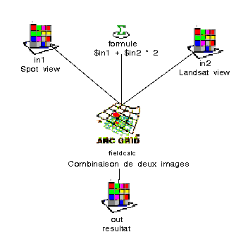
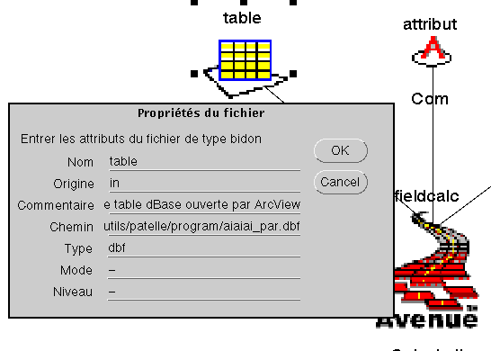
The main originality of Patelle is to use graphic programming of the processing chain. Each elementary step of a processing chain is visualised in a diagram (c.f. figure 1).
The process parameters are visualised as graphic objects. Each graphic object has a set of properties attached to it : pathname and type (for files), string (for text parameters), name of program, code, name of the machine (for commands).
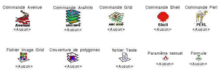
This mode of representation allows operations coded in AML language (ArcInfo, Grid), Avenue (ArcView, Spatial Analyst), SML (ERDAS Imagine), DOS, Shell, Perl, etc. to be used from the same user interface.
The graphical metaphor hides the complexity of the process implementation : each process is a "black box" which can be combined with others into a chain.
Patelle is delivered with a library of pre-defined process templates which include the most common operations : data import, cover merge, raster/vector transformation, combining images, etc.. This library offers a set of "black box" routines which do the job, but do not require specific programming skills from the user or any knowledge of how the job is actually implemented.
Each template has an associated on-line help which describes in detail the parameters of the process and when necessary syntax information or recommendations written by the author of the template.
This function of Patelle allows distribution of tested and validated processes and facilitates reuse of the code. It also stimulates the spread of GIS techniques out of the circle of GIS programming experts.
New templates can be added to this library and the on-line help is generated and updated automatically.
Patelle is available on PCs and UNIX workstations (Sun and DEC Alpha). Processing chains created with Patelle can be used in both environments.
Patelle can activate local or network processes. The access to servers such as ArcInfo is provided through ArcView inter-applications communications protocols (DDE and RPC).
This function allows to share more efficiently software tokens available on a network and to take advantage of available CPU resources.
Patelle is strongly linked to ArcView concepts and data model.
It is essential to be an experienced user of ArcView in order to use Patelle. ArcView was selected in early 1995 by the Sillage group and since then has spread considerably within IFREMER. Patelle helps take advantage of this situation and greatly enlarges ArcView possibilities.
Import and export procedures have been carefully studied in order to be opened to other data formats used by Sillage partners.
The management of a GIS processing chain involves the following phases :
An advanced function of Patelle allows configuration of its external interfaces and addition of new process templates.
Patelle is available in French and English versions.
The user interface includes :
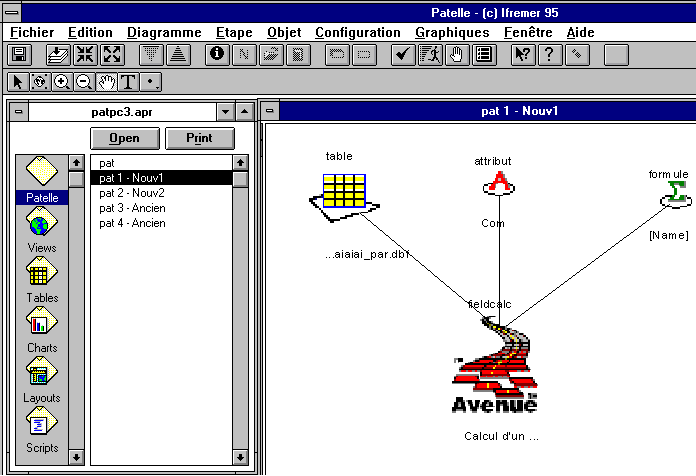
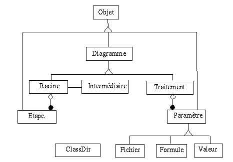
In Patelle, a processing chain is described with a hierarchy of steps. Each step is either made of sub-steps or is an elementary process.
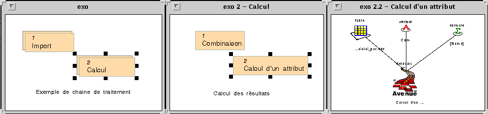
The creation of a processing chain involves the following phases :
Patelle also provides the following functions :
This function allows the setting of the values of the parameters used when the process command is executed :
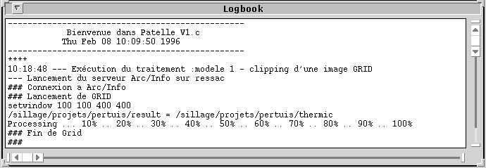
This function allows execution of a processing chain or part of it and display of the execution results.
This function allows display of the results in tables, graphs and view and preparation and printing of reports and layouts.
It is directly inherited from ArcView and is fully described in ArcView user manuals and on-line help.
Patelle is delivered with a set of process templates. If necessary, the user can also add his own templates.
A template is made of two parts : a graphic description in a diagram of all the objects of the process (parameters and commands) and a code section which contains the commands sent to the local or network service which executes the process.
Patelle configuration includes three sub-functions :
Patelle analysis and specifications were carried out under TeamWork using the SA/RT module.
The object oriented design was made on the basis of the OMD method from J. Rumbaugh.
Patelle was written entirely in Avenue language except for RPC communication programs needed on UNIX workstations only.
Since Avenue does not allow to create your own class of objects, a set of scripts was developed to implement this functionality.
Each script includes a header which enables automatic production of the design documentation in hypertext HTML or ArcView on-line help format.
Patelle has been implemented as an ArcView 3 extension which can be added or removed from a project.
Patelle is currently being tested to answer questions asked by GIS projects for fisheries management in the Mediterranean and aquaculture near La Rochelle.
The concept of graphic programming has demonstrated its capability for the handling of a complex processing chain to all the partners of the GIS project.
[Durand-95] Dossier de Spécifications Fonctionnelles de PATELLE, Groupe Sillage, 95, Réf: DITI/DSI/MU/CD-020.
[Durand-95] Manuel utilisateur de PATELLE, Groupe Sillage, 95, Réf: DITI/DSI/MU/CD-021.
[Esri-95] Introduction à Arc/View, Esri, UBS 1.5M5/95.
Christophe Durand, ( Christophe.Durand@ifremer.fr)
Brigitte Guillaumont, ( Brigitte.Guillaumont@ifremer.fr)
IFREMER, Institut Francais de recherche pour l'exploitation de
la Mer
Groupe Sillage
BP 70
29280 PLOUZANE, France
Tel : (33) 98 22 43 18
Fax : (33) 98 22 45 33
WWW : DITI/DSI service développement de systèmes informatiques
Jean Prou, ( Jean.Prou@ifremer.fr)
CREMA, Centre de recherche en écologie marine et aquaculture
BP 5
17137 L'HOUMEAU, France
Tel : (33) 46 50 06 10
Fax : (33) 46 50 06 00