|
||
E R D A S ® Geographic Imaging Made Simple.
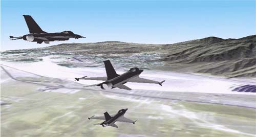
IMAGINE VirtualGIS can be used to create a realistic visualisation of SPOT satellite imagery and 3D vector objects. The user can manipulate the scene, find data attributes, do intervisibility analysis, digitise or select flight paths and fly through the imagery in real time, on systems from UNIX workstations to low cost WindowsNT and 95 PCs. ERDAS offers a range of scaleable solutions for those who create and extract information from imagery for GIS or image processing, those who use imagery products and those who simply want to visualise their data, whether in 2D or 3D. ERDAS IMAGINE®, the leading, scalable suite of products for image mapping and visualisation, image processing and advanced remote sensing. The product is modular, allowing users to choose the products that suit their needs. Each is designed around the same interface, providing a powerful, seamless environment for Geographic Imaging professionals, whether on UNIX or Windows.
The ARCVIEW IMAGE ANALYSIS EXTENSION from ERDAS brings easy-to-use Geographic Imaging to the ArcView Desktop GIS - from very fast image handling and full, dynamic geocorrection to image categorisation and feature extraction. For the first time, work with imagery in ArcView seamlessly and quickly. The IMAGE ANALYSIS EXTENSION has been developed by ERDAS and Esri in collaboration to ensure the highest level of integration. As a core extension to ArcView developers can use new Avenue commands to integrate IMAGE ANALYSIS capabilities into their applications. ERDAS MapSheets™ - allows you to quickly and easily create mapping presentations for Microsoft Office 95/97, wherever your data is from. Create maps in minutes from your imagery and map data, which can then be edited in-place in any OLE application, such as Word, PowerPoint or published on the web. MapSheets provides labelling, visualisation tools, as well as data handling through Microsoft Excel – to provide compelling business graphics for all users.
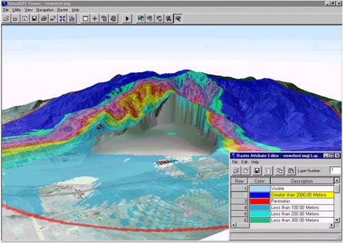
IMAGINE VirtualGIS has been used here to visualise the effect of quarrying. Visibility analysis allows us to determine the visual impact of the possible work. Decisions can then be made as to whether the project is viable and what its impact on the surrounding environment will be. ERDAS is the mapping software company specialising in Geographic Imaging solutions since 1978. The company is the world leader in highly customisable, easy to learn and use Geographic Imaging software. With over 35,000 users in 106 countries, supported by a network of 60 distributors, ERDAS can support you in whatever you do, wherever you are. Contact us!
Copyright
© 1998 ERDAS, Inc. All rights reserved. |
||
| Back to the List of Exhibitors | ||
    |
||
     |
||
 |
||
| [Introduction] [Conference programme] [Presentation by author] [Presentation by category] [Poster session] [List of exhibitor] [List of European Esri distributor] [Esri products news] [Credits] |