|
 |
ArcInfo Version 8 - First LookBy David J. Maguire, Director of Product Planning, Esri At Esri there is a real sense of excitement about ArcInfo Version 8. Over the past two years the 100-person ArcInfo development team has been evolving the whole concept of GIS software. ArcInfo Version 8 reflects the future of GIS representing a new approach to GIS unlike any available.
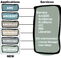
The antecedents to ArcInfo Version 8 are the best elements of Esri's current software products: the sophisticated geoprocessing tools of ArcInfo Version 7, the strong usability and integration capabilities of ArcView GIS; the leading-edge client/server and all-relational architecture of the Spatial Database Engine (SDE), and the popular component architecture of MapObjects. ArcInfo Version 8 is the first release of Esri's next-generation software architecture that will unify our software family. Applications and ServicesIt is convenient to think of ArcInfo Version 8 as an integrated software system of "desktop" applications and "back office" services. The desktop applications include the existing ARC, ARCEDIT, and ARCPLOT applications (plus all the existing extensions--ArcExpress, ArcPress, ARC COGO, ARC GRID, ARC Network, and ARC TIN). These applications have been updated and extended in ArcInfo Version 8 (e.g., there are new COGO tools, new translators, and many enhancements). This means that existing ArcInfo Version 7 applications and databases will be binary compatible with ArcInfo Version 8 and will continue to operate unmodified.
Additionally, some new, easy-to-use, menu-driven applications will be introduced for the first time in ArcInfo Version 8--ArcStudio, ArcManager, and ArcToolbox. ArcStudio is a new mapcentric application for displaying, querying, and analyzing map data. An object-based editor will also be introduced that plugs into the ArcStudio application. (For existing ArcInfo users, this is like the next generation of ARCEDIT and ARCPLOT integrated together.) The editor is highly interactive and rule-based with powerful tools for creating and maintaining geodatabases. ArcManager is a new datacentric application that allows users to locate, browse, and manage geodata. It is like a spatially enabled Windows Explorer. ArcToolbox is a menu-driven application for performing geoprocessing operations such as conversion, overlay processing, buffering, and map transformation. The ArcInfo Version 8 services include user setup to install applications; the license manager; data servers such as ArcSDE, ArcStorm, and ArcInfo LIBRARIAN; and the interapplication communication server (IAC) that supports client/server communication across networks. Also new in ArcInfo Version 8 is an ArcServer that allows a desktop application to call powerful tools to perform operations such as overlay, proximity analysis, data loading, or database commits. The ArcServer is built using ODE and the ArcInfo Version 7 geoprocessing tools. In this client/server model an ArcInfo desktop application is able to request the services of the ArcServer. The results of the server operation are returned to the client desktop application for display. Data ModelArcInfo Version 8 introduces a new data model that will make it easier for people to define and work with geodata. ArcInfo software's existing georelational model uses a row in a tabular database to represent a geographic entity such as a parcel, road, or manhole. In this model, the feature type is defined purely by the attribute data; a parcel is no different than a building, a road no different than a stream. Each feature is made from two-dimensional geometry and a collection of attributes. At Version 8 the georelational data model will continue to be used for existing applications. The new technology will add an object-oriented data model that provides a means to encapsulate "behavior" with the feature data. It allows applications to define and work directly with actual domain objects (e.g., parcels, roads, or manholes) instead of just rows in a database. This will allow developers (including Esri) to create custom objects relevant to particular domains and work with them as objects (e.g., forest areas, highways, and wells). Second, there is really no difference between Esri-supplied and developer-supplied objects. Finally, and most importantly, all Esri objects have default behavior for tasks like editing and display that can be reused by custom objects through programming. This means that developers can concentrate on implementing just the behavior they wish to customize and can rely on the Esri objects for all other behavior. The new data model also offers the ability to deal with multiple data sources and databases in a consistent way. Conceptually, this is an extension of the DEFINELAYER capability in ArcInfo Version 7, although it has been implemented using new technology. For example, an ArcStudio user performing an edit operation on an SDE database might want to use an existing ArcInfo coverage or Esri shapefile of some land base information for background context. The new technology in ArcInfo Version 8 will support seamless access to all these data sets within the same application. Data ManagementFollowing the direction taken in ArcInfo Version 7.2 to encourage users to work with ArcSDE as the main database management solution, Version 8 relies on ArcSDE to manage access to multiuser databases. To facilitate integrated ArcInfo-SDE multiuser editing, there will be a new release of ArcSDE. ArcSDE software's new features include Direct Editing and Long Transaction and Version Management support. At ArcInfo Version 8 a user can invoke the editor within the main display window of ArcStudio, connect to an ArcSDE database, start a long transaction on a versioned database and begin direct editing of the database. When all the required edits have been performed the transaction can be closed. If someone else had been editing the same features at the same time, a new version would be created in the database. Tools will be provided to manage a versioned database (e.g., resolve conflicting versions, remove redundant versions). ArcInfo Version 8 ReleasesThe initial ArcInfo Version 8 release includes all the core technology described here. The display and query tools will work with all object types, whereas the editor is more specifically focused on point, line, and network applications such as electric, gas, and water utility database maintenance. A follow-on ArcInfo Version 8.1 release will add additional capabilities in a number of areas including support for editing complex polygon-based data (e.g., land records). Usability and ScalabilityAlthough ArcInfo Version 8 contains some very powerful and sophisticated technology, one of the key goals of this release has been to make ArcInfo easier to use and more accessible to typical GIS users. A key part of the design and engineering has been understanding the tasks that GIS users perform on a regular basis, be it maintaining a database, making a map, integrating data, or creating a report. The result is that ArcInfo Version 8 has a visual interface that provides common GIS tasks out of the box. ArcSDE will be the database manager for multiuser editing. A single-user version of ArcSDE (lightweight and simple to administer) will be included in ArcInfo Version 8. Traditional ArcInfo data sources such as coverages, shapefiles, ArcStorm databases, and ArcInfo LIBRARIAN databases will also be accessible as read-only data sources. MigrationWe imagine that users will deploy ArcInfo Version 8 in various ways, including
ConclusionDesigned from first principles and coded completely from scratch, ArcInfo Version 8 technology offers a visual user interface that directly supports common GIS tasks. Based on industry standards and created with extensibility and ease of use in mind, it defines the next stage in the GIS software industry and will establish a new benchmark for GIS software. At the same time, ArcInfo Version 8 maintains binary compatibility with Version 7 data and applications. A new focus of ArcInfo Version 8 is the concept of applications and services. Desktop applications can make requests to different GIS server and administration services located on the same machine or another machine over a network. For more information on ArcInfo, please call Esri at 1-800-447-9778 or your regional office. Outside the United States, please contact your local Esri distributor, or visit Esri online at www.Esri.com/arcinfo. |
    |
     |
 |
| [Introduction] [Conference
programme] [Presentation by author] [Presentation by category] [Poster session] [List of exhibitor] [List of European Esri distributor] [Esri products news] [Credits] |