|
 |
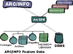
ArcSDE: The Universal Spatial Server for ArcInfoArcSDE is an extension that supplies the same Spatial Database Engine (SDE) server as enterprise SDE, and the SDE for Coverages server that provides access to the file system databases. ArcInfo is the tool of choice for building and maintaining intelligent spatial databases. These spatial data are stored in numerous file-based formats: coverages, map libraries, ArcStorm databases, and Esri shapefiles. The vast majority of today's spatial data are contained in one or more of these popular formats. Billions of dollars are spent worldwide annually to construct and maintain these ArcInfo databases. Leveraging these vast data holdings is a challenge. Today, you need to provide access
to all of your data. Your ArcInfo databases are
increasingly integrated in corporate information systems.
To provide open access to ArcInfo databases you need
ArcSDE. ArcSDE is a special release of Esri's SDE technology for ArcInfo users with an additional capability to serve existing data formats.* Its purpose is to integrate SDE client/server technology within ArcInfo. This solution brings the many benefits of SDE to all users of the world's leading professional GIS software system. ArcSDE includes
Why ArcSDE?
*ArcInfo license required. |
    |
     |
 |
| [Introduction] [Conference
programme] [Presentation by author] [Presentation by category] [Poster session] [List of exhibitor] [List of European Esri distributor] [Esri products news] [Credits] |