 |
 |
ArcView GIS Version 3.1 - Working For You
Building upon the ArcView GIS that you already know, Version 3.1 provides a robust platform from which existing and new extension functionality can be readily and reliably deployed. Exciting new features include
The release of ArcView GIS Version 3.1 keeps Esri's ongoing promise to be responsive to user requests for needed functionality and performance enhancements. Crystal Reports Included Select report types from a set of standard reports including standard listings, mailing labels, forms, and cross tabulations. Create a "Quick Report." Even define your own custom reports. Once you've created your report, print it and even export it into a metafile ready for inclusion in your ArcView GIS Layout. Be an Expert at Advanced
Geoprocessing These and other enhancements of ArcView GIS Version 3.1 make this your most powerful, yet easy-to-use, desktop GIS. |
    |
     |
 |
| [Introduction] [Conference programme] [Presentation by author] [Presentation by category] [Poster session] [List of exhibitor] [List of European Esri distributor] [Esri products news] [Credits] |
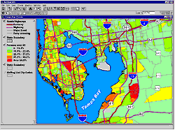 With ArcView
GIS Version 3.1, Esri continues to provide the world
standard in full-featured desktop GIS.
With ArcView
GIS Version 3.1, Esri continues to provide the world
standard in full-featured desktop GIS.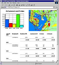 ArcView GIS
users want the ability to produce standard and custom
reports. ArcView GIS Version 3.1 offers Seagate Crystal
Reports, providing report generating and editing
capabilities within existing ArcView GIS Table, View, and
Project graphic user interfaces.
ArcView GIS
users want the ability to produce standard and custom
reports. ArcView GIS Version 3.1 offers Seagate Crystal
Reports, providing report generating and editing
capabilities within existing ArcView GIS Table, View, and
Project graphic user interfaces.