|
 |
Next Generation IMS Technology Matched with ArcExplorer Version 1.1MapObjects IMS Version 2.0 Now AvailableThe second generation of Esri Internet Map Server (IMS) technology is now available in the form of MapObjects IMS Version 2.0. ArcExplorer integration, improved map server setup and administration, and support for Web-based data distribution distinguish this generation of IMS technology.
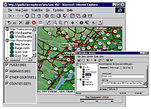
MapObjects IMS is a MapObjects extension for creating Web mapping applications. Originally designed for Windows developers who wanted to build custom Web applications, MapObjects IMS Version 2.0 adds new features that make creating and serving dynamic Web maps uncomplicated. "MapObjects IMS Version 2.0 is as easy to use as ArcView IMS and yet as extensible as MapObjects," states Mike Tait, manager of Internet Development. Support ArcExplorer ClientsThe highlight of MapObjects IMS Version 2.0 is the ability to serve maps and data to ArcExplorer. Released last summer, ArcExplorer is Esri's lightweight GIS data explorer available at no cost from Esri's Web site at www.Esri.com/arcexplorer. ArcExplorer has become a popular choice for a variety of display, query, and data retrieval applications. ArcExplorer Version 1.1 was released this summer and adds several new features. Map query functions such as identify, find, and the query builder all work with maps served over the Web by MapObjects IMS Version 2.0. Feature labeling is enhanced and includes automatic placement and conflict detection. Finally, ArcExplorer Version 1.1 can match individual addresses to Esri shapefiles. In addition, MapObjects IMS Version 2.0 can serve ArcExplorer as an ActiveX document. ActiveX documents work with Microsoft Internet Explorer. Internet Explorer becomes the frame for using ArcExplorer to dynamically interact with maps and download GIS data. Suitably configured MapObjects IMS applications check the Web browser software and install the ArcExplorer ActiveX document if necessary. Whether as a stand-alone application or an ActiveX document, ArcExplorer is the ready-made client for MapObjects IMS. Serve ArcExplorer Project FilesThe ability to serve ArcExplorer project files makes it easy to set up a Web mapping service using MapObjects IMS Version 2.0. An ArcExplorer project file is essentially a map view that is a collection of themes/layers with defined display symbology and scale dependencies. To make a new Web mapping service, simply drag the ArcExplorer project file into the IMS Administrator tool, set the download properties, and press the play button. Data DistributionMore than just a method to publish dynamic maps over the Internet, MapObjects IMS Version 2.0 allows you to distribute both vector and raster data over the Internet. You define which themes/layers of GIS data can be downloaded. For instance, you may let users download city boundary data but not download a street network. Administrative ToolsMapObjects IMS Version 2.0 includes tools to administer map services through a graphic user interface. Administrators can set permissions, establish data downloads, start and stop applications, query the status of a network of map servers, and link to sites where users can purchase your GIS data. Moreover, administrators can log in remotely from anywhere across the Internet/Intranet to manage and query their map server system. For more information on MapObjects IMS, please call Esri at 1-800-447-9778 or your regional office or visit Esri online at www.Esri.com/mapobjectsims. Outside the United States, please contact your local Esri distributor. |
    |
     |
 |
| [Introduction] [Conference
programme] [Presentation by author] [Presentation by category] [Poster session] [List of exhibitor] [List of European Esri distributor] [Esri products news] [Credits] |