Paul Manson
Trimble Navigation Europe Limited, Trimble House,
Meridian Office Park, Osborn Way, Hook, Hampshire RG29
9HX, U.K. tel (+44)(0) 1256 746 281 fax (+44)(0) 1256 760
148, paul_manson@trimble.com
Abstract
OLE automation
technology has dramatically expanded the potential market
for GIS software engines and GIS data, by allowing GIS
technology (such as Esri’s MapObjects) to be
embedded in custom applications.
The same OLE automation technology can now be used to
embed high-accuracy GPS capability in custom
applications. Trimble’s Pathfinder Tools software
development kit includes four OCX (Active X) controls for
configuring, controlling and monitoring of GPS receivers,
and to enable easy conversion of GPS coordinates and
units.
Providing ease of integration without compromising GPS
accuracy, Pathfinder Tools is the first OLE-based
software toolkit to provide differential post-processing
capability, for higher GPS accuracy. Pathfinder Tools
offers sub-meter accuracy in the field, with Trimble's
Pathfinder XR and XRS GPS receivers, and also works with
Trimble's PCMCIA-based Pathfinder Card, allowing
plug-and-play GPS integration.
The combination of MapObjects and Pathfinder Tools
enables software developers and systems integrators to
easily create a wide variety of powerful GPS/GIS field
applications.
INTRODUCTION
The Global Positioning System (GPS)
has long been a valuable tool for GIS data capture
applications. Recent technological advances have made GPS
more useful and more cost-effective as a data capture
tool, and sophisticated systems for Mapping and GIS data
capture are now offered by a number of manufacturers.
Many of these systems provide superb accuracy,
reliability and functionality, and are ideal for a
variety of general-purpose data collection projects.
But for organisations which have
already made an investment in field computing systems,
the economics and ergonomics of equipping each field
worker with an independent GPS system are often
unattractive. For such an organisation, a far more
desirable solution would be to build GPS capability into
their existing hardware and software. Such a solution
could maximise the value of GPS while minimising the
impact on field staff and their work practices.
GPS INTEGRATION
Until recently, the only way to
integrate GPS into a custom application has been to
communicate directly with the GPS receiver, using either
a GPS manufacturer’s proprietary protocol or an
Industry Standard protocol such as the National Marine
Electronics Association’s NMEA 0183. Most budding
integrators chose NMEA, as it provides a large degree of
GPS receiver independence, is an easily parsed ASCII
format, and allows rapid embedding of GPS. However NMEA
is a one-way protocol, providing no software control over
the GPS receiver’s configuration or operation. NMEA
also provides no ability to differentially post-process
GPS data, which forces anyone looking for higher GPS
accuracy to also purchase a GPS receiver with an integral
or external real-time radio. This incurs additional
equipment cost, and also inevitably restricts the areas
where the equipment can be used, as it is difficult to
guarantee 100% coverage with most real-time differential
GPS services.
Interfacing with a GPS receiver using a
manufacturer’s proprietary communications protocol
has its own advantages and disadvantages. On one hand, it
is normally possible to configure and control the
receiver, and provide a far greater degree of feedback
than is possible with NMEA. It may also be possible to
record sufficient information to differentially
post-process GPS data. On the other hand, most
proprietary GPS formats are extremely complex, and are
applicable to only a single GPS receiver or family of
receivers. Although many systems integrators have
invested countless software development hours in GPS
receiver integration, the GPS industry is evolving at
such speed that only a handful have ever managed to
implement a reliable customised GPS interface which
includes post-processing capability.
But now there’s a better way.
Trimble, the leader in GPS
Solutions, has recently introduced a product that allows
software developers and systems integrators to easily
embed GPS into their applications. This product, called
the Pathfinder Tools Software Development Kit (SDK),
provides support both for integrated real-time
differential GPS and also for post-processing. The
enabling technology is the same software platform
that’s allowing software companies to embed GIS
capability: OLE automation. Trimble’s Pathfinder
Tools software suite provides four ActiveX (OCX) OLE
automation controls, which can be easily embedded in a
32-bit Windows application (i.e. Windows 95 and Windows
NT).
PATHFINDER TOOLS
Pathfinder Tools currently consists
of four ActiveX software controls:
- The GPS Receiver
Control. This manages all GPS data communications
between the GPS receiver and host application,
including the configuration and control of
real-time differential corrections from radio
beacons and satellite sources. A simulation mode
provides the ability to record and
‘replay’ GPS positions for testing and
demonstration purposes.
- The Coordinate Transformer
control provides easy and accurate coordinate
conversion from latitude and longitude to any of
over 650 published coordinate systems and zones.
You can also create custom coordinate systems
using Trimble’s Pathfinder Office software
suite, and use these with Pathfinder Tools. In
addition, you can use Pathfinder Office and
Pathfinder Tools to create a
‘calibration’ of GPS data to
practically any existing map or GIS database.
- The Units Converter
component simplifies the translation of angle,
length, velocity, and time units and the
conversion of GPS heading information from true
to magnetic north.
- The SSF Writer
component saves GPS data in Trimble’s
Standard Storage File (SSF) format, so that you
can subsequently perform differential GPS
post-processing on the data using Trimble’s
Pathfinder Office™ Software. Pathfinder
Office, which is included with Pathfinder Tools,
provides a host of GPS data viewing, editing and
processing facilities, in addition to GIS export.
The ability to create and post-process SSF files
can be crucial when you are collecting data in
environments where the power and dependability of
differential post-processing is required.
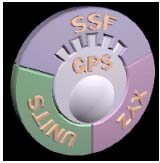
Figure 1
The Pathfinder Tools Icon
|
An application can choose
to include any or all of these four ActiveX
controls, and can hide the entire default user
interface, or any part thereof. This allows the
actual field user of the application to see only
what GPS information is relevant to them (if
any), and makes it possible to embed GPS without any
visible UI modifications at all, if appropriate. |
PATHFINDER TOOLS
MAKES IT EASY
Building Pathfinder Tools into your
application is extremely easy. Just install the Toolkit
and then drag and drop the ActiveX control onto a window
in your application. The control doesn’t necessarily
expose any UI on this window, and the window itself
doesn’t need to be displayed (it just provides the
control with ‘a place to live’).
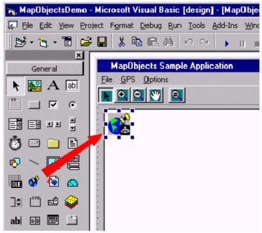
Figure 2
Drag and Drop the GPS Receiver Control
When you run your application, you
must call a single method objGPSReceiver.StartTracking to start the GPS interface. You can
pre-configure the GPS receiver, or can expose either the
default UI or your own custom UI to configure the GPS
receiver, either prior to activation or subsequently. If
requested, the GPS receiver control will scan your PC's
serial ports for a GPS receiver, so you don’t even
have to rely on the user connecting the receiver to a
specific port.
From that point onwards, you have GPS positions available
to your application. It’s up to you to decide what
you use these for. You can record GPS positions, use GPS
to automatically pan the map, or use GPS to guide you to
a specified point on the map or in your database.
Pathfinder Tools itself comprises the four ActiveX
controls mentioned earlier. The toolkit also includes a
set of custom utility controls providing some of the
typical displays you’d expect to see in a GPS
application:
- A skyplot, showing where the
GPS satellites are in the sky and which ones
you’re using.
- A speedometer and compass.
- A precise clock.
- An Activation Wizard for
Pathfinder XRS receivers which require a user to
‘activate’ a satellite differential
service before it can be used.
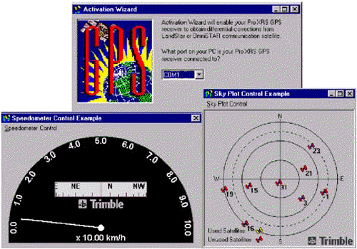
Figure 3
Sample Custom Controls
Applications built with Pathfinder
Tools are showcased on Trimble’s web site, together
with an interactive Object Diagram showing how easily you
can interface to GPS using Pathfinder Tools.
WHICH GPS
RECEIVERS CAN I USE WITH PATHFINDER TOOLS?
Using Pathfinder Tools, you can
currently interface to three types of GPS receiver,
offering a range of GPS capabilities:
- Pathfinder XR is a 12-channel
GPS receiver with an integrated 2-channel MSK
Beacon DGPS receiver, which uses a single
integrated GPS/MSK Beacon antenna. The convenient
packaging and low power consumption make this an
extremely attractive option in areas where
coastal MSK Beacon coverage is available. In
Europe, there are coastal beacons operating
around the Baltic sea, in the North Sea, around
the coasts of the UK and France. Experimental MSK
beacons have been established in Spain and
Portugal, and are being planned by a number of
other authorities. The beauty of these beacons is
that they provide GPS differential corrections
free of charge to all users. The typical
real-time accuracy of the Pathfinder XR is
sub-meter, although this degrades slightly as you
move further away from the coast. The
post-processed accuracy of the Pathfinder XR is
50cm.
- Pathfinder XRS is a 12-channel
GPS receiver with two integrated DGPS receivers.
The first of these is a 2-channel MSK Beacon
receiver, similar to that of the Pathfinder XR.
The second integrated radio receiver decodes
signals from geosynchronous satellites, providing
sub-meter DGPS positions virtually anywhere on
earth. The satellite signals are transmitted by
two different companies, Landstar and Omnistar,
and are not free of charge. However there are a
variety of pricing options based on the type of
service you require, and satellite differential
services provide a very cost-effective means of
getting high accuracy without the need for your
own GPS base station infrastructure. As with the
Pathfinder XR, the Pathfinder XRS achieves 50cm
accuracy in post-processing mode. The Pathfinder
XRS is an extremely compact system, with a single
receiver and a single antenna, allowing for very
flexible use in a wide variety of applications.
- Pathfinder Card is an entire
8-channel GPS receiver on a Type II PCMCIA Card.
The external antenna connects directly to the
Card, which can be inserted in the PCMCIA slot of
any laptop, notebook or pen computer for
extremely easy and cost-effective integration.
Pathfinder Card achieves differential GPS
accuracy of between 1 and 3 meters, either by
post-processing or in real-time (through the use
of an external differential GPS radio receiver).
Figure 4
Supported GPS Receivers:
The Pathfinder Card and Pathfinder XR/XRS
An application developed with
Pathfinder Tools will automatically work with all three
of these GPS receivers, without the need for specific
coding or testing for each supported receiver. This
provides considerable flexibility to the end user of an
application built using Pathfinder Tools. They can
operate different GPS equipment in different areas, to
suit the accuracy requirements of different projects, and
the DGPS availability in different areas. They can also
mix and match equipment to reflect changing project
requirements.
WHAT MAKES
PATHFINDER TOOLS UNIQUE?
Pathfinder Tools offers substantial
benefits over other methods of interfacing to GPS:
- Ease of integration. Drag and
Drop ActiveX technology means you can be up and
running with live GPS in your application within
minutes. One of Trimble’s beta sites managed
to add GPS to their (MapObjects) application,
test it and deploy it within 10 hours!
- No compromise on GPS quality.
Using Pathfinder Tools, you don’t have to
choose between ease of integration (NMEA) and
high performance (proprietary protocols). You can
achieve the highest levels of DGPS accuracy, and
still have constant quality assurance and total
program control over the configuration and
operation of the GPS receiver.
- The ability to log GPS data
for subsequent post-processing, down to 0.5m
accuracy with the Pathfinder XR and XRS
receivers.
- Automated, high-quality
transformation of GPS positions to the coordinate
system of your choice. Transformation of other
GPS data, such as speed, heading, time, etc to
your selected units.
PATHFINDER TOOLS
AND MAPOBJECTS: PERFECT PARTNERS
Pathfinder Tools and MapObjects are
extremely compatible products, due to their shared
reliance on OLE Automation technology. With Pathfinder
Tools, it’s extremely easy to add GPS capability to
an application built with MapObjects: just drag and drop!
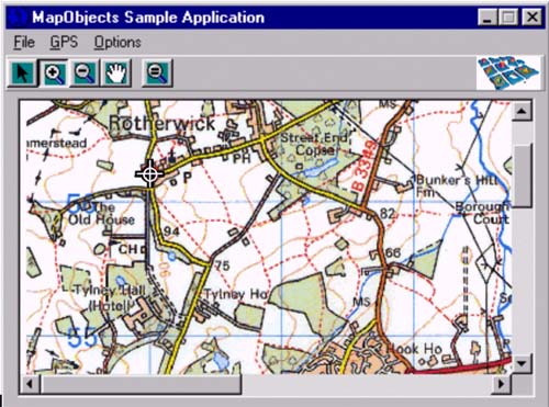
Figure 5
Pathfinder Tools and MapObjects
If you have a solution built using
MapObjects, you easily add GPS capability using
Pathfinder Tools for the following kinds of applications:
- Map Panning and Tracking
Applications. Add GPS positions to the MapObjects
Tracking Layer; it’s designed precisely for
the display of ephemeral graphical information.
- Data Capture. Record GPS data
to a Shapefile or other data store. At the same
time you can also record raw GPS data directly to
a Trimble SSF file for subsequent
post-processing, and after that for merging with
the Shape data.
- Data Validation. Use GPS to
‘navigate’ to points on the map or to
automatically search for the ‘nearest’
feature in the database.
CONCLUSION
It’s now very easy to combine
a GIS engine such as MapObjects with a GPS engine
(Pathfinder Tools), and create a custom application which
knows where it is and knows about the geographic
environment in which it’s operating. These software
and hardware components open up a whole new range of
customised GIS applications, from data capture and
validation to field work-order management and vehicle or
asset tracking.
OLE automation is allowing GPS to be easily embedded
within custom GIS applications, without sacrificing
flexibility, GPS accuracy or ease of use. As a result,
GPS is making its way into many organisations, often
without users being particularly aware of its presence.
GPS is being used for simple tasks such as automatically
panning maps (in tracking and viewer/query systems), as
well as for more obvious tasks such as navigating to and
mapping the location of a particular GIS feature.
REFERENCES
- Trimble Navigation Limited, 23
July 1998, "Pathfinder Tools Object
Diagram", see http://www.trimble.com/gis/pft.htm. This www site also provides other
information on Pathfinder Tools, including a data
sheet, FAQ and a list of Pathfinder Tools
developers.
|


