Alessandra Ferrara
Basi Territoriali e Sistema Informativo Geografico, ISTAT
- Istituto Nazionale di Statistica, Via A. Ravà 150,
00142 Roma, tel (+39-6) 54074399 fax (+39-6) 5943011, ferrara@istat.itOrietta Gargano
Basi Territoriali e Sistema Informativo
Geografico, ISTAT - Istituto Nazionale di Statistica, Via
A. Ravà 150, 00142 Roma, tel (+39-6) 54074399 fax
(+39-6) 5943011, gargano@istat.it
Antonello Iacobelli
Olivetti Ricerca, Contrada La Marchesa, S.S.271 Km.8.680,
70020 Bitritto - Bari, tel (+39-80) 6352059 fax (+39-80)
6352089, iacobelli@olivettiricerca.it
Giovanni Biallo
MondoGIS, Via Montevideo 4, 00198 Roma, tel
(+39-6) 85354740, fax (+39-6) 85354727, g.biallo@mondogis.it
Abstract
The project
GeoServe aims to develop a network of Geo-data Access
Services for Data users and Data Providers. The Services
shall support the identification, selection, and timely
access to geo-data for data users at European and
regional scale. For the provider of geographic data the
system will enable the marketing of geo-data to a large
international user group.
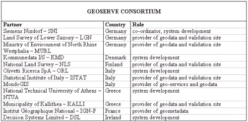
Figure 1
Figure 2
FOURTH FRAMEWORK
PROGRAMME OF EUROPEAN COMMUNITY DGXIII
FIELD: RESEARCH
AND TECHNOLOGICAL DEVELOPMENT "TELEMATICS
APPLICATIONS PROGRAMME"
SECTOR:
ADMINISTRATIONS
Starting date: January 1996
Ending date: December 1990
Duration: 36 months
SHORT OVERVIEW OF PROBLEMS
EXISTING AT EUROPEAN LEVEL
WHO PRODUCE WHAT?
The first problem on access geodata and alphanumeric
geocoded data comes from the lack of a reference centre
to ask at European and often national level. Additional
to surveying institutes, which perform data acquisition
of geographic basis data (raster and vector data,
satellite images, aerial photography) there are many
other data providers on the market who are involved with
enhanced data: e.g. they produce thematic data packages
or convert data to various GIS.
WHAT DATA AND WHAT QUALITY?
In Europe there is a big pool of geodata already
collected from different member states. Europe has the
excellent quality and variety of data but there is no
co-ordination between the different suppliers. Since
surveying institutes operate off-line, it is difficult to
collect complete information about existing database.
This results in lack of awareness of existing data and in
a redundancy in data acquisition and data storage. On the
other hand there is an insufficient update of data. Thus
when a potential user might find background topographical
maps for a county the information requested might not be
the most actual version produced.
HOW CAN A USER GET THE DATA AFTER
IDENTIFYING THE REQUIRED DATA POOL? WILL THE INFORMATION
BE DELIVERED ON TIME?
Communication procedures are inefficient and systems for
data requirements and data supply are inadequate. Today
ordering is through telephone and fax and delivery uses
snail mail for data stores.
WHAT DATA HARMONISATION?
Numerous de jure and proprietary de facto standards for
data formats are in use in Europe. Numerous projections,
national regulations and legal obstacles make data
exchange difficult between systems and even more crossing
borders.
THE GEOSERVE PROJECT TRY TO
GIVE ANSWER TO SOME OF PROBLEMS DESCRIBED ABOVE
ADVANTAGES:
- central source for geographic
data information
- accessibility for everyone by
WWW
- availability to get original
data direct from the World Wide Web
- easy to use access to the
information on available geodata via public
information kiosks or networked PCs
- availability of enhancement
services as conversion of geographic data into
the requested format or projection
transformation.
- the system enables a brokering
market
WORKPAKAGES AND DELIVERABLES
The work in the GeoServe project
will be carried out in the frame of 8 main workpackages:
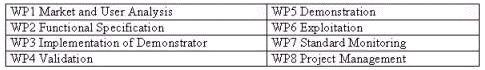
Figure 3
To enhance the clarity of the
overall work structure, each main WP is split into
several specific WP’s.
For each WP (main/specific) a final document
(Deliverable) will be drew by the responsible partner.
Deliverables already closed and further information on
the project are available on the Geoserve Web site: http://www.geoserve.de
PARTNERS ROLE
Data user
Potential data users are public administrations, private
companies and citizens who should like access to geo-data
or geo-service for territorial/urban planning, business
location planning, geocoded data etc.
For the data user the system contains powerful
functionalities to retrieve information on available
geo-data sets. The user may select data by a combination
of a browser on a meta-database and a geographic access.
The system supports added value services like conversion
and compression to make the data directly usable in the
target system GIS or viewer. Conversion will be offered
between a set of transfer formats. This will enable an
open system supporting various national standards and
de-facto standards used in today's market GIS. Additional
enhancement functionalities are provided for spatial join
of different maps. For enhancement services that include
interaction with GIS or specialised knowledge and
capabilities users may select services offered on the
network by specialist companies.
data provider
Public or private companies who produce and process
geo-data.
For data providers the system offers management and
delivery functionalities for advertising the data, for
actively distributing it, and for selling it effectively.
Through the data provider user interface on the data
provider client geo-data may be brought to the network.
The data provider will specify the related
meta-information for the data and its marketing. On
delivery of geo-data billing and bookkeeping
functionalities provide for effective marketing.
data enhancer
Data enhancers on one hand are data users of primary
geo-data. On the other hand they are providers when they
distribute and market the enhanced geo-data, and carry
out geo-services as production of thematic maps (added
value maps by overlaying, intersecting etc.), format
conversion, scale and/or co-ordinate transformation.
SYSTEM FUNCTIONALITIES
Whole process, from data access to
final data ordering, is served by a set of
functionalities which allow:
GEO-DATA SEARCH AND SELECTION
At European level by consulting the
metadatabase in which geographic and alphanumeric data
(metadata), and geographic services (metaservices) are
described, users get information about identification,
location and contents of geo-data and geo-services
available at national level.
Is it possible to identify and also to select the
required datasets by two different ways:
- thematically, by metadatabase
navigation, identifying the objects and related
attributes described inside. Additional
information regarding data contents, formats,
convertibility, standards, and pricing schemes
may be obtained before specifically order the
required data.
- geographically, by naming the
area or by zooming on maps. Using a viewer system
and zoom facilities, the location and geographic
coverage of maps may be selected. The
specification of the maps may be viewed via
examples.
The present MDB navigation at
European level involves access to a selected information
set from metadata collection:
the Meta Data Kernel (MDK), got by each national provider
for its demonstrator. The user verify dataset
characteristics and availability on national site, by
connecting with European site and consulting the MDK.
The MDK contains information about data set and their
identification keys (ID): data set group, name, language,
abstract and purpose of production; scale, projection,
and spatial schema of cartographic data set; temporal and
geographic extent, units of distribution, format and
price of data; company and country reference.
After have defined the ID’s list the user can
consult the required data, by connecting with national
sites. On national site, the Italian demonstrator, will
support the MDB navigation for access to the complete
metadata collection (standard CEN TC 287).
Metadata
Metadata, as database info-document, are a basic tool to
describe to users the available data set and their
characteristics.
Data model used in GeoServe project concerns only
database structure, and not the content: the database
entities and their relationships are described according
to European standard established in CEN TC287 Metadata
Standard (document no. prEN 287009), that deals with
metadata about geo-datasets. A geo-dataset can be a
simple raster map as well as a huge vector geo-database.
Both of them have been described in the Italian
metadatabase.
The model proposed in CEN TC287 is composed by different
sections: Dataset id, Dataset overview, Dataset quality
elements, Spatial reference system, Extent, Data
definition, Classification, Administrative metadata,
Metadata reference and Metadata language. The sections
have been identified as entities, while the different
sub-terms have been assumed as the corresponding
attributes. The following is a brief description of the
different entities (objects) in terms of their attributes
(entries of the tables).
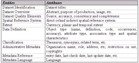
Figure 4
On the regional sub server,
metadata about regional geodataset are described in deep
detail (MDB), while the European site contains only a
subset of metadata entities (MDK).
Metadata are going to be implemented and managed in a
standard RDBMS on a telematic network (Internet).
SHOPPING BASKET AND DATA
ORDERING
Each user can manage functions of
data and/or service searching, selecting, changing
request, etc. by the shopping basket module. By
this module, specifically developed for functions above
described, all requested data and geo-service are
registered and can be checked by users before defining
and mailing the final order form to national Data
provider.
When the user have defined the complete list of the data
is interested to, the system will calculate an estimated
price for the whole amount of data requested.
CONTRACT MANAGEMENT
Off-line the system administrator
define different kind of contracts. One of these will be
automatically associated to data selected in the shopping
basket.
A disclaimer contract , which the user just have to agree
upon, is setted for free data the user will not use in
commercial application.
All other contracts needs of signature by the user who
require data. A traditional contract (paper form) will be
sent to user from system administrator. When the user
will send back to server the signed contract, the data
delivery will be activate.
LEGAL CONTROL
The legal control is carried out by
data and/or service provider. Defined procedures and
rules assure the correct and lawful access to data as
well as the data safety and confidentiality. The whole
procedure let the user know if the data are available for
shopping; shows the contract version associated to data
requested with peculiar provisions (ex copy right
provisions); shows a summary page listing all data
required; calculates the data price for unit; ask the
user to accept all the conditions of contract.
DELIVERY
Three kind of delivery are
available in the system:
- on-line delivery by Internet
HTTP and FTP via mail box (disclaimer contract)
- deferred delivery via mail box
by user’s resident directory on HTTP server
(standard contracts);
- off-line delivery via
traditional mail (standard contracts).
At the end of delivery phase the
real final price of data will be calculated in static and
dynamic way:
- static way: data price, a
priori fixed, will be calculated in relation to
total request of data extraction and delivery on
selected support;
- dynamic way: variable data
prices in relation to global amount of requested
data;
SYSTEM ADMINISTRATOR
FUNCTIONALITIES
- Off-line contracts set up
- User administration: accounts
management; payment instructions; statement of
banking transactions; ordering list and state;
etc.
DATA PROVIDER ADMINISTRATOR
- Metadatabase updating (by
Internet connection between providers and
sub-server HTTP);
DEMONSTRATORS
The GeoServe system will provide a
set of regional Geo Data Service Nodes (GDSN) providing
detailed metainformation, regional specific geodata,
geo-services and broker functionality. A European GDSN
will guarantee the overview and coordination of the
network of regional GDSNs.
The European GDSN will be located on Denmark; the
regional GDSN’s will be setted for the demonstrators
of Greece, Italy, Germany and Denmark.
The content of the demonstrators is based on
implementation of the GeoServe products in the
representative user environments. The implementation
includes installation of the GeoServe application and
realisation of the data distribution aimed for the
specific markets.
The demonstrators will support different geo-clients, for
Data users in administrations, based on PC / Windows and
citizen info kiosks.
A variety of geo-clients support the specific needs for
casual as well as for a professional users who link the
system to their local GIS. The openness of the concept is
underlined by linking a variety of GIS systems,
geo-viewers, and geodatabases. Within the project these
will be ArcInfo/ArcView, SICAD, GeoView etc.
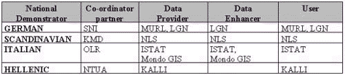
Figure 5
Partners DSL and IGN will
co-operate by providing applications and data, which will
be integrated into demonstrators.
AVAILABLE DATASET SCHEMA
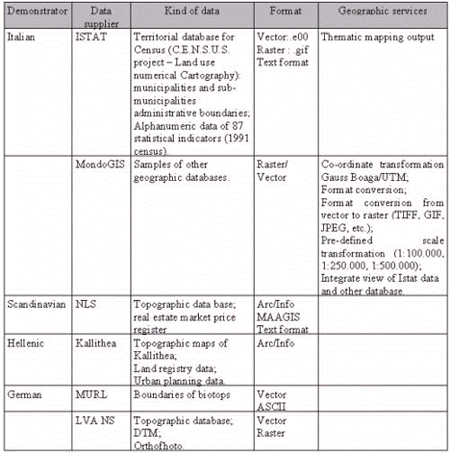
Figure 6
ITALIAN DEMONSTRATOR
Olivetti Ricerca, Istat e MondoGIS
will build up the Italian demonstrator; at Bari’s
site Olivetti Ricerca will provide a public Web server.
The user connected via Internet link, can verify the
availability and characteristics of data by consulting
the metadatabase catalogue and activate all functions of
searching, selecting, sampling etc. above described.
Since users have defined the final order of geodata
selected, the server will activate an automatic
procedure. By connecting to Istat (Data provider) via
ISDN dedicated link, the requested geodata will be
extracted and mailed to client.
If even geo-service are enclosed, the request will be
sent to MondoGis company (Data Enhancer) which will
operate in off line mode.
Moreover MondoGis will register and pigeon-hole requests,
by classifying for different users, geo-services, etc.
The access to demonstrator will be possible by each
client (personal computer) connected to Internet.
Istat, as Data user in the
demonstration phase, will install:
- a public Info-kiosk (provided
by Olivetti Ricerca) with an Internet browser,
available at Istat Data shop of Rome (Via
Depretis)
- a personal computer with
router for ISDN link to Olivetti Ricerca server
in Bari, available at Istat office of Rome (Via
Ravà).
ISTAT DATASET
As Data provider, Istat will
furnish about the Milan and Bari provinces the following
dataset:
- geographic dataset:
Municipalities administrative boundaries
Inhabited areas boundaries
Enumeration areas boundaries
- alphanumeric dataset:
set of 87 statistical variables collected at
1991 Census, available for Municipality and
Provinces by Enumeration areas and Inhabited
areas.
Data are grouped in 19 dataset and
described into the Metadatabase. For each dataset a
sample (thematic map) is available.
For Bari’s Municipality and Province samples of
thematic maps are placed at the end of this paper.
DATASET SCHEMA for Italian
demonstrator
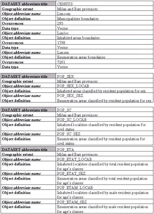
Figure 7
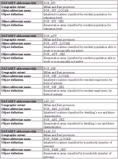
Figure 7a
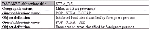
Figure 7b
GEOGRAPHIC SERVICE
The MondoGIS company play the Data
enhancer role into Italian demonstrator. A set of
geographic services will be provided to users.
Metadatabase contains information and descriptions
(standard CEN/TC 287) about several geo-database
which users can decide to see and/or buy, in addition to
ISTAT data, to produce thematic map based on more than
one layer. Samples of such other geographic databases
will be presented into metadatabase.
Moreover the MondoGIS will provide a wide group of
"traditional" geographic service which include:
- co-ordinate transformation
Gauss Boaga/UTM;
- format conversion for the most
common GIS tools (Esri, Intergraph, MapInfo,
Autodesk);
- format conversion from vector
to raster (TIFF, IF, JPEG, etc.); pre-defined
scale transformation (1:100.000, 1:250.000,
1:500.000);
- integrate view (added value
maps by overlaying, intersecting etc.) of Istat
data and other database.
By means of a mapserver tool (Esri
product) it will be possible to look at data sample of
each available database; to select different thematic
layers; to check the scale value; to identify and get
information about geographic data selected.
Moreover MondoGis will register and pigeon-hole requests,
by classifying for different users, geo-services, etc.,
to build up a file describing the user typology.
SET OF STATISTICAL VARIABLES
AVAILABLE FOR INHABITED AREAS AND ENUMERATION AREAS,
DESCRIBED AS ATTRIBUTES INSIDE ISTAT METADATABASE
Source: ISTAT - 13° General Census
of Population and Houses -
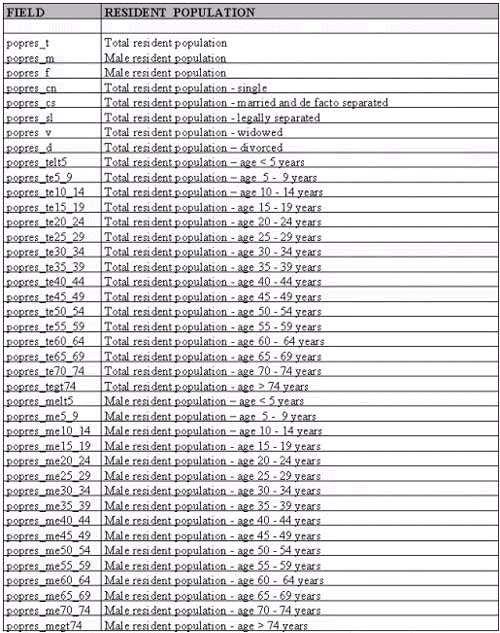
Figure 8
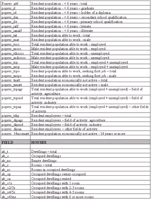
Figure 8a
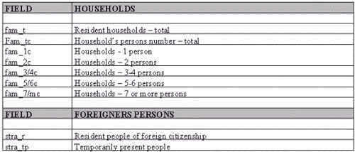
Figure 8b
ISTAT contact persons:

Figure 9

Figure 10
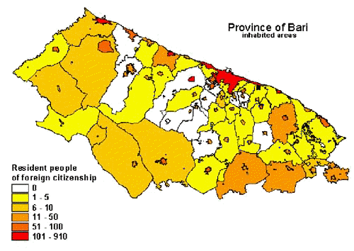
Figure 11
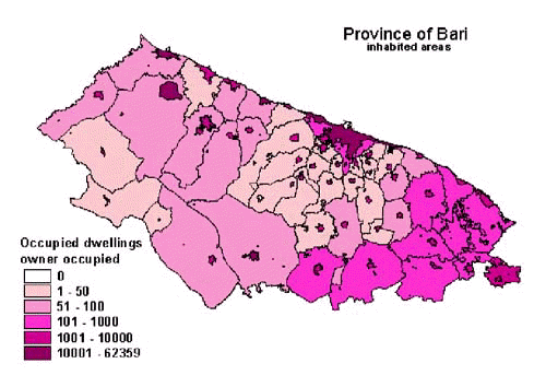
Figure 12
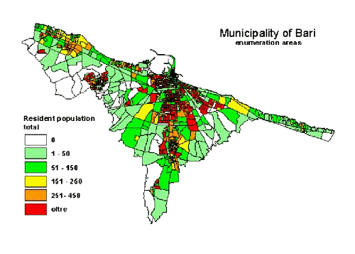
Figure 13
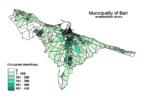
Figure 14
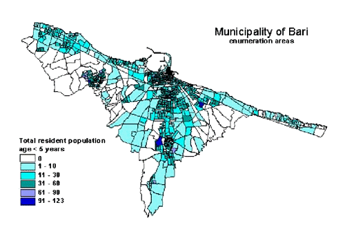
Figure 15
|


