Antonio Andronico
Dipartimento ambiente della Provincia di
Alessandria, Via Galimberti 1, 15100 Alessandria, tel
(+39-131) 304570 fax (+39-131) 226575Claudio Magagna
Ufficio SIT Provincia di Alessandria, Via
Galimberti 1, 15100 Alessandria, tel (+39-131) 3045593
fax (+39-131) 226575
Sandro Teruggi
Università degli Studi di Pavia -
Department of Hydraulic & Environmental Engineering,
Via Ferrata 1, 27100 Pavia, tel (+39-382) 505300, fax
(+39-382) 505589, teruggi@ipv36.unipv.it
Jadranka Korlat
Ecostudio s.r.l., Via Mameli 33, 15033
Casale Monferrato, tel (+39-142) 451515 fax (+39-142)
71027, ecostud@docnet.it
Paolo Brusotti
Ecostudio s.r.l., Via Mameli 33, 15033
Casale Monferrato, tel (+39-142) 451515 fax (+39-142)
71027, ecostud@docnet.it
Abstract
The subject of
the paper is the case study about developement of the
G.I.S. of the Province of Alessandria, Department for
Environment and Territory, it stresses the method that
was applied for planning and introduction of G.I.S.
describing:
- feasibility study with
organization study and investment planning;
- piklot project, executive
design and development of geographic databases
and applications with particular atrtention on
"on the job" training;
- presentation of results.
1. INTRODUCTION
The Province of Alessandria decided
in 1996 to develop a Geographic Information System as a
support its decision making and operational management
activities
At present informatic tools are being developed and
informatic support being given only in two areas of the
province’s activities: finances and the protocol.
In other offices the use of computers was sporadic and
unstructured. Data exchange and share of resources and
information were not possible. In general the informatic
capabilities of the employees was quite low and it is
considered inappropriate for a modern public institution.
Regarding the level of
information technology application in the Province of
Alessandria and having analyzed those of other
provinces, the Province administration have decided
to upgrade its potentials in the field and proceed as
follows:- to commission an expert to draw up the
feasibility study that will became an operation
management document and, in addition to its regular
contents, will cover the following issues:
- phases of of the
project’s developement;
- investment plane
- training program
- selection of an
appropriate site and implementation of a
pilot project;
- developement of full
scale project based on pilot project
findings;
The principles that had to be
respected were:
- the investement should
be made gradually in accordance with the
spread and the real use of GIS in the
Province’s services and departments
- the know how should be
gradually transferred to the relevant
staff of the Province which should
undergo the appropriate training program.
2. THE FEASIBILITY STUDY
The feasibility study for the
implementation of the GIS was assigned to Ecostudio
s.r.l.. The areas concerned by the study were those of
Environment and Spatial Planning and Management.
In order to obtain the initial feed-back and to highlight
the importance of the study and of the project as a whole
as well to safeguard the participation and collaboration
of the management and the staff, a presentation
conference was organized. The conference was attended by
the administration and the participant were the managers
of the departments involved in the study.
The first part of the conference was dedicated to the
fundametals of the GIS technology. In the second part the
working plan was presented, the methodology to be applied
and the forms to be used by interviews, the way of
results’ presentation, and the means of
communication. At the same time persons responsible for
every office were nominated.
The elaboration of the feasibility study requested six
months of work in close collaboration between the
consultants commissioned and the staff of the Province.
The work started with gathering of data using printed
forms compiled in interviews with relevant staff members.
The information gathered dealt with macroorganisation,
procedures and activities performed by different offices,
data classes and flow ( i.e. data origin, destination,
users, ways and means of data archiving and retrieval),
different types of thematic maps (origin, scale, date map
production and update) and on informatic facilities and
needs. The results of data gathering were elaborated and
analised by the experts of Ecostudio and verified by the
appropriate staff members of the Province.
The writing up of the final document involved numerous
meetings with representatives of the Province, in wich
the possible scenaria were discussed. In that way the
solutions proposed are believed to meet closely the real
needs of the Province.
The conclusions drawn in the
document were:
- the GIS introduction of the
GIS should be divided in four phases:
1° pilot project –
regarding Waste management and faunistic and hunting
Institutions management;
2° Province of
Alessandria’s Territory Spatial Developement
Plan;
3° Water resources planning
and management;
4° Civic protection;
- hardware: the highest priority
was given to structured wiring of the offices of
two respective departments and the development of
the appropriate LAN-Local Area Network The LAN
project had to be made within the pilot project
study and it had to be made operational by the
time of finishing the pilot project. - software:
considering the type and the initial amount of
spatial data to be handled as well as the staff
of the Province’s informatic skills, it was
decided to start the project implementation with
a less sophisticated GIS and RDBMS software
(Arcview, Access) and to defer the applicatio of
more complex software;
- human resources: analyzing the
organization of the Province the organisational
scheme of its GIS Service and internal
comminications between the offices such as
presented in Figure 1 have been proposed in the
Study. In the beginning the Service could be
composed of one single persons who would follow
and coordinate the work of external experts.
- training plan: the training
method should be "training by doing"
and should involve the training of System
Manager, Data Base Administrator, GIS operators
and GIS users.
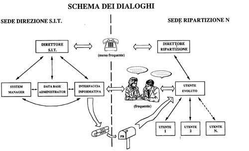
Figure 1
Organizational scheme
3. PILOT PROJECT
The pilot project started in May
1997. At the same time the GIS Service was formeed to
wich Mr. Magagna was assigned as a first staff member.
The project proceeded in sequence
as follows:
- introduction conference with
presentation of the project to future operators;
- data collecting by compiling
printed forms in interviews in the presence of
the GISService’s employee;
- definition and validation of
data structures;
- design of structured wiring
and LAN creation;
- realization of data structures
in Acces;
- organization of the
information levels of the Regional Technical Maps
(scale 1:10.000, called CTRN) in the logical sets
in function of the project’s necessities;
development of user intefaces for agevolating
maps retrieving (figure 2)
- realization of the prototype
of the user interface for retrieving the
geographic database;
- realization of the user
interface for data entry;
- supervising of data entry;
- training.
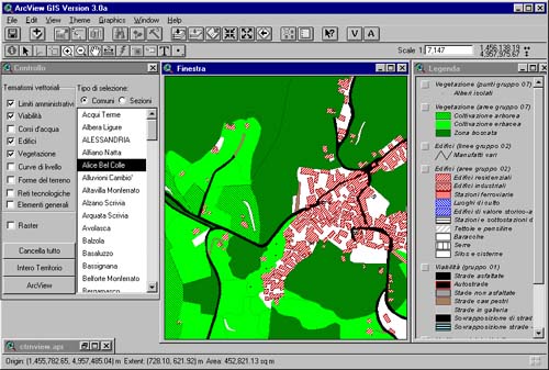
Figure 2
User interface for CTRN querying
During the project the consultants
made an effort to intensify the team work with the staff
of the Province. The intensive team work helped the
experts to acquire extensive and reliable information. On
the other hand the staff of the Province gained a
precious experience and the beginning of training.
After two months of work the GIS service was unederpined
by one more staff. At the same time two graphical
workstations equiped with Arcview software were acquired.
These events marked the start up of the training program.
The training program involved the staff of the GIS
Service and the end users of all the offices involved in
the project.
A special program was prepared for managerial
staff’s training. As per request of the
Province’s staff the numer of hands-on training
lessons was not limited . Some special arguments were
clarified in individual tutorials, expecially with
managers. To the great extent the training was done by
participating of the consultants in the development of
single internal projects (for instance IRIDE –
Relief of vegetation and cultivations inside the
faunistic and hunting protected areas, etc.).
The wiring and LAN have been realized according to the
design. One file server under Windows NT operational
system has been installed, all the processing is done
locally on the single PCs. The existing computers were
checked, some were replaced other were upgraded and
reused for simpler tasks. The following criteria was
applied: the old machines were assigned for simpler tasks
and new machines were introduced for performing GIS
operating stations.
4. SPATIAL DEVELOPMENT PLAN
As a part of this project the
Province of Alessandria completed the digital vectorial
acquisition of the Regional Technical Map (CTRN, scale
1:10.000) for the areas for wich existed only paper and
raster maps.
The geographical data base regarding Territory
Development Plan was structured following the principles
of GIS technology. All the thematic maps converted into
digital data format, georeferenced, coded and linked with
attribute data. The work accomplished so far is under the
approval process.
FUTURE PROJECTS
According to the plan contemplated
in the feasibility study the third phase dealing with
water resources is being implemented. It will be followed
by the GIS applications in civic protection.
There is an interest in extending the project to the road
system’s departments.
The Province administration intends to make a part of
geographical data of large professional and public
interest available through an Internet site.
A project is under consideration within the Province
aiming at providing technical support to its
municipalities and assisting them in training, selection,
introduction and implementatin of GIS technology.
CONCLUSIONS
In comparison to the other similar
projects, the Province of Alesadria opted for an initial
intorduction of simpler GIS technology, that will
gradually be repalced by more sophisticated one in the
future. It is thought that the loss of possibilies of
generating new information in the initial phase will be
compensated by the smooter introduction of the new
technology, avoiding thus the traps of initial
"technological shock" that had serious negative
implications, experienced in the other similar projects.
The initially obtained result was the large dissemination
of the GIS technology within the Province’s
services. It has become a real tool for daily work. In
the moment of submitting this paper 7 Arcview licenses
have been installed and more than 10 users trained. An
important achievement is the fact that the GIS concept of
coping with data of spatial nature by means of GIS
funcionalities has affected the mentality of the
employees so that the implementatio of the new- GIS based
technology is now enthustiastically being proposed for
almost all the new projects. The expected paradigm shift
is gradually taking place even among the "hard
core" of the employees who oposed or were very
reluctant to GIS introduction. Another important side
effects was the general improvement of informatics
perception at various levels including standardizing of
informatic components including both hardware and
software as well as data handling procedures (coding,
storage).
At the end importance of the implementation of proper
training methodology. It has to be flexible, personalized
and extended over an appropriate period. Best results are
achieved when both trainer and trainee take part in GIS
intorduction by solving the ongoing operational problems
.
The introduction of GIS raises the interests of the
future users, provides the consent for its use in future
projects and makes it an integral part of the whole work
process.
|


