|
| SITAP: THE GEOGRAPHICAL DATABASE OF ITALIAN CULTURAL AND ENVIRONMENTAL RESOURCES |
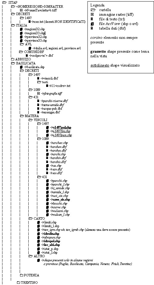
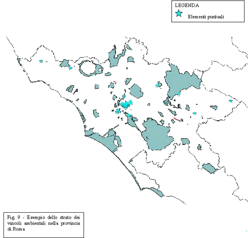
| Fabio Carapacchio Ministero per i Beni Culturali e Ambientali – Ufficio Centrale per i Beni Ambientali e Paesaggistici, Piazza del Popolo 18, 00189 Roma, tel (+39-6) 32659858, fax (+39-6) 3201390 f.carapacchio@mbca-ucbap.interbusiness.it Paola Tenaglia Abstract SITAP is a nation-wide geographical database of Italy realised from 1987 for the Ministry of Cultural and Environmental Resources and still under implementation. It contains spatial and descriptive data on areas of environmental, scenic or public value protected by law. Using Esri GIS technology (ArcView, MapObjects, Internet Mapserver) we realised three different tools to retrieve information, produce maps and reports and implement the database at three different levels: getting easy information on our environment via Internet, administrative use of central and local offices of the Ministry to control and manage protected areas, study and definition of new areas to protect and implementation of database with new or more detailed information. INTRODUCTION SITAP is a complex and articulated database on Italian areas under law protection from the Ministry of Cultural and Environmental Resources, within which the geographical elements are integrated with the descriptive ones, stored as tables, texts or images. We can assert that it can integrate different information of various types of environmental resources, can store maps acquired at different scale factors, can plot very detailed views on regard of the various types we need and can be easily updated in progressive steps, can be integrated al different levels. Its nucleus is made of the ATLAS database, already presented at Esri’s conferences of the past years, progressively enriched of new layer and functionality. The primary sources of information were the cartography of I.G.M.I. (Italian National Geographical Military Institute) and the laws that protect environmental, architectural, archaeological and artistic beauties in Italy. Cartography was chosen because of its nation-wide completeness and because of its scale (1:25000) suitable to the identification of most areas, whose original description (textual or cartographic) not permitted a better positional accuracy than 10-15 meters (about half a centimetre at this scale). Directly from these maps we digitalized administrative boundaries, coastlines, hydrography, contour lines, while areas protected by the different laws were first identified and drawn on the same maps according with the description of the decree and with the help of its associated cartography. Only woods were taken from different cartography, then projected on the other layers. Descriptive data were stored as tabular data and related by codes to the graphical elements. Five years after the end of ATLAS project, we added new data: 2000 architectural beauties were acquired with new rules - a more detailed catalogue-card and the raster images of the original documents of the decrees (made of technical reports, photos, detailed maps, etc.) documentation about "usi civici" (common lands); the textual version of all decrees published on the G.U. (the official Bulletin of Italy). The original database underwent in these two years drastic transformation: originally in the national system of co-ordinates, it was then projected in UTM, from ArcInfo release 4 VMS was updated to release 6 UNIX and the ArcInfo coverages has been turned into ArcView shapefiles. Recently a complete review of protected areas has been undertaken, while two other databases have been integrated: I.G.M.I. cartography TIFF images in UTM co-ordinates and administrative boundaries from last (1991) census of the national statistical institute (ISTAT). STRUCTURE OF DATABASE The structure of the database is shown in fig1.
As you can see it is basically organised according to Italian administrative regions and provinces, within which shapefiles and tables are divided in "base map" layers, "protected areas" layers - subdivided according the type of law which they are subjected to. Particular layers, not present on the whole database but only in some provinces, are stored under the "other" directory. This organisation will permit us to transfer quite easily the entire database under the SDE structure. I’ll show now a quick overview of SITAP layer.
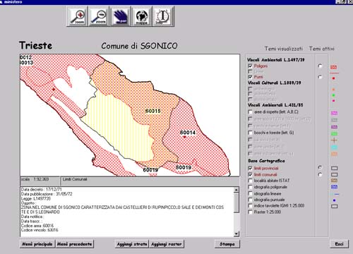
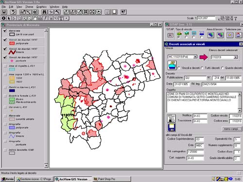
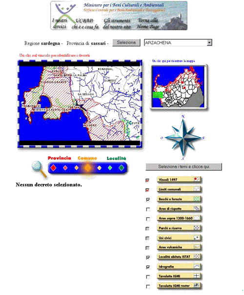
USER INTERFACES Three user interfaces have been developed after the conversion into shapefiles and under Windows NT. The first, already distributed in CD-Rom to the regional administrative bureaux of the Ministry of Environmental and Cultural Resources, has been developed using MapObjects 1.2. Query selection and hard copy operation are very simple and easily understood by people with little knowledge of computers and information processing. The first window with the map of Italy starts the application. By clicking on it you go to the main menu, that permits the choice of the working area (region, province, commune) or of a decree. During the session the extension of the area can be changed as often as required going back to the previous menus. The first option let you see a view with a graphical window with administrative boundaries of the region, the legend with the themes you can put on, tools and buttons for the following functions: pan, zoom in, zoom out, identify, whole extension of selected area, add theme, back to main menu. The option "province" has a more complex view with some layers of protected areas already on and a wider choice of layers. They have now two radio buttons - one makes the theme visible or not, the other makes it active or not, that’s it makes it possible to retrieve information by selection. The colour legend is fixed because the shadeset has been studied to optimise the overlay of many layers. Some layers are visible only below a certain scale factor. Also TIFF images of I.G.M.I. cartography can be added only below the scale of 1:30000. The window with the information on the selected elements of the active theme is below the graphic one. If it is a protected area it is possible to open another window with the text of the decree, that you can print. It is also possible to print the view on the screen thanks to a prepared layout in a standard format. To select a commune (fig. 3) you must first select the region and the province and then, by a scrolling list the name of the commune you want. The choice of a decree must pass through the same selection (region, province) and then you are required to digit the dates between which the selection must be done. Fig. 3 The second user interface has been developed using Avenue and the Dialog Extension which comes with ArcView 3.1 or can be downloaded from Esri’s site. It is dedicated to the more skilled personnel of the Ministry, which has the task of studying new areas to put under protection of law or of implementing the database. For this reason it contains all functions - tools and buttons - of native ArcView 3.0 plus a tool windows with newly created buttons for the choice of the type of selection – working area or date of decree - and of the type of protected area on which information can be retrieved – at the moment only natural areas protected by law 1497. The window below shows the schematic description of the selected area and of its associated decrees. It is possible to view all other fields of the dbase table and update fields content (fig. 4). It is also possible to modify the shapefiles and their legend in the main view. Another button opens the window with the text of the decree, which is then possible to print. Fig. 4 The third application has been studied to permit to everybody to investigate this database through the net. Developed using MapObjects and MapObjects Internet Map Server 1.0, it has the same purpose of the other interfaces but with the typical interface limits imposed by the use of HTML language. From a map of Italy it is possible to chose the region and then from a more detailed map of the region to chose the province. You then have on the screen the general map of the province with the layers of administrative boundaries and areas protected by the law 1497 on and a scrolling list of all communes. The function of pan is activated through a compass-card or by clicking in the smaller "navigation" window on the right, while coloured buttons permit to zoom out and in. It is possible to add the other layers from the legend and retrieve information on protected areas by clicking on them in the main map. (fig. 5)
|
     |
    |
 |
| [Introduction] [Conference programme] [Presentation by authors] [Presentation by category] [Poster session] [List of european Esri distributors] [List of exhibitor] [Esri products news] [Credits] |