Tibor Tullner
Division of Information Management, Geological Institute
of Hungary, Stefánia street 14, H-1143 Budapest, tel
(+36-1) 2206194 fax (+36-1) 2510703, tullner@mafi.hu
Abstract
The paper
presents the system design and the implementation of the
digital national geologic database of Hungary in a pilot
1:100.000-scale area. Setting up digital national
geological databases is one of the priorities in many
geological surveys throughout the world. These projects
raise a number of challenges. One of them is the
elaboration of a uniform legend incorporating all
geological formations occurring in the country. Not less
important are defining the data structure of the results
of exploration methods (wells, geophysical measurements,
in-situ tests, laboratory data) supporting the
interpreted geological formations and developing
applications facilitating the query of the database as
well as the creation of derived maps.
One of the central questions of the project is to
organise the database in a way facilitating most the
creation of applied maps and other interpreted products
for practical purposes, like the composition of
concession packages or environmental projects financed by
the Ministry for Environment and Regional Policy.
The project started with the elaboration of a standard
geological legend that was completed within 3 years.
System design is basically finished this year and will be
slightly modified to accommodate comments resulting from
testing the system in a pilot area. The project is
planned to be completed by 2002.
Digital data acquisition and pre-processing proceed in
the Microstation environment. The GIS database is set up
in the Esri ArcView 3.0 - Oracle system.
Themes of the database are organised in several views
that can naturally be altered. They include:
- Geological map
- Geological layers
- Geological thickness maps
- Geological profiles
- Geophysical explorations
- Wells
- Aerial images
Apart from the
functionality provided by standard ArcView tools a
customised application was developed supporting the
display of images representing
- Drawings of geological
base profiles in exposures
- Description of base
profiles
- General description of
base wells
- Lithostratigraphic profile
of base wells
- Pictures of well cores and
thin sections.
INTRODUCTION
The Geological Institute of Hungary
was founded in 1869 and it was almost 90 years ago that
it could move into its present headquarters representing
one of the most spectacular monuments in Budapest (Figure
1).

Figure 1
The headquarters of the Geological Institute of Hungary
During the 130 years of its
activities the Geological Institute of Hungary has been
responsible for the acquisition, processing and
management of geological and geology-related data, the
latter including disciplines like hydrogeology,
engineering geology, environmental geology, pedology and
geophysics.
One of the most important issue in the activities of the
Institute is the management of basic geological
information represented on geological maps. It can be
used as the basis for processing derived maps tailored to
the needs of potential customers including firms engaged
in environmental management, exploration of mineral
resources and water supply etc. In order to improve the
quality of providing the customers with reliable
geological information there has been an increasing
demand for setting up the uniform digital geological
database of the whole country with a surface of 93.000 km2 on the
scale of 1:100.000.
The process of the standardisation of geological data and
maps has already started a couple of years ago and
involved a number of respected experts, but it was this
year that the first unit of a pilot area has been
completed using GIS. This paper describes the challenges
met and mastered so far in this process as well as the
data architecture, thematic layers and the experience
gained during the project.
CHALLENGES
They were numerous and they can be
summarised in the next hierarchy:
- setting up uniform legends
- defining database themes and
structure
- defining the application
environment
- ensuring flexible database
handling procedures
Though it does not directly
implicate GIS, setting up a uniform legend of the related
themes was an indispensable prerequisite of the success
of the project. In the language of GIS it concerned the
definition of the attributes each thematic layer has in
the geological database covering the whole country. It
required an agreement between geological experts
- using slightly different,
private approach in the geological mapping
procedure
- having eventually different
views on the evolution of certain geological
formations
- involved in mapping of hilly
or plain areas requiring different methodology
- specialised in mapping on
specific scales (small, or large).
It has not been an easy process and
it is still not quite clear whether a completely uniform
legend can be used for hilly and plain areas. The results
of the standardisation have been published in a paper [1]
providing the basis for setting up the digital database.
Database themes have been selected upon their priority of
furnishing useful data, availability and the possibility
of their organisation in a standard database. Several
specific projects supported the choice of the most
important items that helped us pinpoint the most needed
entities.
As of the application environment we were eager to set up
a database that has a certain independence of the hw/sw
environment but priority has finally been given to the
ArcView - Oracle system.
ArcView 3.0 provides a number of easy and flexible tools
for data management and representation helping us avoid
the necessity of developing sophisticated applications.
Nevertheless, a specific extension has been created for
the management of some point data types as well as for
representing related images and HTML documents.
TECHNICAL BACKGROUND,
PROCESSING PHASES
As previously described the
database has been set up in the ArcView - Oracle system
under both UNIX and WINDOWS NT. Though the difference not
large, first of all the developed application had to be
slightly redesigned for flawless operation under both
systems.
One of the basic aspects of the project was the design of
the tabular database in the Oracle system. Priority was
given to the relational aspect and simplicity.
The most important table is the MSTR_GEOLOGY (Table 1)
including master information in unique records for each
specific geological formation occurring in Hungary.
Table 1
| TABLE NAME |
MSTR_GEOLOGY |
Standard classification of
geological units |
| |
FIELD
|
TYPE
|
LENGTH
|
DESCRIPTION
|
| geo_ndx |
C
|
12
|
ID
of the geological unit (formation) |
| Age |
C
|
12
|
Age
of the geological unit |
| formation |
C
|
50
|
Classification
of the geological unit |
| facies |
C
|
56
|
Facies
of the geological unit |
| lithology_desc |
C
|
142
|
Lithological
description of the geological unit |
| lithology |
C
|
20
|
Lithological
description of the geological unit using standard
abbreviations |
| FORMATIOm_H |
C
|
|
Classification
of the geological unit (in Hungarian) |
| FACIES_H |
C
|
|
Facies
of the geological unit (in Hungarian) |
| LITHOLOGY_DESC_H |
C
|
|
Lithological
description of the geological unit (in Hungarian) |
| LITHOLOGY_H |
C
|
|
Lithological
description of the geological unit using standard
abbreviations (in Hungarian) |
Tables and views
defined in the Oracle environment are related to this
table when it comes to the definition of geological
formations.
Table 2 represents processing phases of the graphic
database with the formats and environment.
Table 2
Item
|
Processing
|
Format
|
Environment
|
| Point
themes |
Add
event theme |
Oracle
table |
ArcView |
| Line
and polygon themes |
Digitising Attribution
Topology
Conversion
|
DGN
files DGN files
Coverage
Shape
|
Microstation
CAD Intergraph MGE
ArcInfo
ArcView
|
| Descriptions,
tables |
Conversion |
HTML |
Internet
Explorer |
| Photos |
Scanning,
conversion |
JPEG |
Internet
Explorer |
| Aerial
images |
Georeferencing |
IMG |
Erdas
Imagine, ArcView |
DATABASE THEMES
After processing the above data
types we have organised different themes in certain views
that gives the best possible overview for potential users
of the database. In the following list view names as well
as themes and data types are indicated by bold italic and
normal italic characters, respectively.
Wells (Figure 2)
- Well_archive - Archive
wells without geological layers (point)
- Well_mafi - Archive,
reinterpreted wells with description of
geological layers (point)
- Well_base - Base wells
(point)
- Well_hydro -
Hydrogeological base wells (point)
- Geo_bn - Map sheet boundary
of the geological map (poly)
Geophysical exploration
(Figure 3)
- Elec_te - Telluric
geophysical measurements (point)
- Elec_mt - Magnetotelluric
geophysical measurements (point)
- Elec_tem - Transient
electromagnetic sounding (point)
- Magnetic - Magnetic
geophysical measurements (point)
- Seismic - Seismic profiles
(line)
- Topo_bas - Topographic base
(line)
- Topo_bal - Annotations of
the topographic base (DGN)
- Geo_bn - Map sheet boundary
of the geological map (poly)
Geological map
(Figure 4)
- Geol_tek - Tectonic lines
of the geological map (line)
- Geol_sol - Polygons of the
geological map (poly)
- Geol_dip - Dip of
geological layers (line)
- Geol_bn - Map sheet
boundary of the geological map (poly)
Geological layers
- Kain_bli - Tectonic lines
on the map of the Cainozoic basement (line)
- Palb_sli - Tectonic lines
on the map of pr-Albian surface (line)
- Kain_bas - Map of the
Cainozoic basement (poly)
- Palb_sur - Map of the
pre-Albian surface (poly)
- Geola_bn - Map sheet
boundary of the geological layer maps (poly)
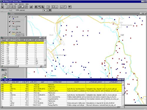
Figure 2
Structure of the view Wells
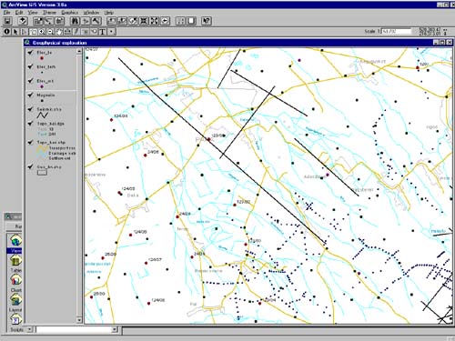
Figure 3
Structure of the view Geophysical exploration
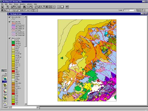
Figure 4
Structure of the view Geological map
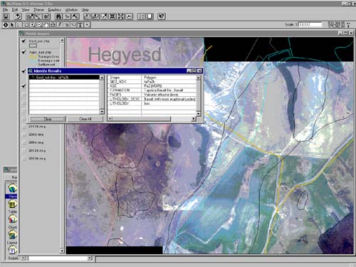
Figure 5
Structure of the view Aerial images
Geological thickness maps
- Pola_thc - Isolines of the
united thickness of Polány and Jákó marls
(line)
- Ugod_thc - Isolines of the
thickness of the Senonian Ugod Limestone
Formation(line)
- Pola_tht - Tectonic lines
of the map of the united thickness of Polány and
Jákó marls (line)
- Ugod_tht - Tectonic lines
of the map of the thickness of the Senonian Ugod
Limestone Formation (line)
- Geola_bn - Map sheet
boundary of the geological layer maps (poly)
Geological profiles
- Bas_prof - Location of
geological base profiles (point)
- Geol_bn - Map sheet
boundary of the geological map (poly)
- Geola_bn - Map sheet
boundary of the geological layer maps (poly)
- Aerim_bn - Boundary of the
area covered by aerial images (poly)
Aerial images (Figure
5)
- Kalimed.img - Mosaic of 8
aerial images
- Topo_bas - Topographic base
(line)
- Topo_bal - Annotations of
the topographic base (DGN)
- Aerim_bn - Boundary of the
area covered by aerial images (poly)
The pilot area covers 2240 km2. As it
can be seen from the above list geological map,
geological layer maps and aerial images for the pilot
area cover different surfaces. Topographic base has been
included in views that are not overcharged with other
data.
Joins and links have been applied for acquiring detailed
data of the geological profiles of wells as a function of
the one-to-one, many-to-one or one-to-many relationship
of database records, respectively.
APPLICATION DEVELOPMENT
A specific Avenue application
converted to an extension has been set up for
representing written documents, tables and pictures
attached to geological base profiles and wells. It
enables the user to acquire the functionality of a view
window for viewing well profiles and photos of well core
samples. Clicking on the respective feature on the map
for viewing written documents and tables launches the
Internet Explorer application featuring the related
document in HTML format. Table 3 displays database themes
and the related information and format that can be
acquired directly through launching the extension.
Table 3
Database theme
|
Document types and format
|
Attached documents
|
| Base
profiles |
Description
of the base profile HTML |
|
| |
Image
of the base profile with English and Hungarian
legend JPEG |
|
| Base
wells |
General
information on base wells HTML |
|
| |
Geological
profile of base wells HTML |
|
| |
Image
of the geological profile of base wells JPEG |
Image
of well cores JPEG |
| Hydrogeological
base wells |
General
information on hydrogeological base wells HTML |
|
| |
Results
of hydrogeological tests HTML |
|
CONCLUSION
The standard 100.000-scale digital
geological map database of Hungary set up for the first
pilot area is presently being tested by experts inside
and outside the Geological Institute of Hungary. On the
basis of the comments the final database design of the
project will be set up. Certainly, several corrections
will be made in order to arrive at the most optimum
solution concerning data organisation.
ArcView is a product, very strongly represented in the
GIS market first of all because of its ability to GIS
data representation, management and analysis on low cost.
Maintenance of basic geological data is the
responsibility of the Geological Institute of Hungary,
therefore it is not our objective to stimulate our
customers to modify e.g. the configuration of geological
boundaries or the attributes of geological formations.
Though the 3.0 version of ArcView supports both, it is
primarily foreseen as a tool for analysing existing data.
In summary, the philosophy of ArcView supports best our
objectives to disseminate and eventually commercialise
geological and geology-related data managed in a standard
uniform digital geological database.
REFERENCES
- L. Gyalog, F. Síkhegyi et al.
(1996) A földtani térképek jelkulcsa és
rétegtani egységek rövid leírása (in
English: Legend of geological maps and short
description of stratigraphic units), Special
publication of the Geological Institute of
Hungary 187, p. 171. [1]
- P. Scharek, T. Tullner and G.
Turczi (1994) - Die Nutzung geographischer
Informationssysteme in der regionalen und
angewandten Geologie - Zeitschrift für
Angewandte Geologie Vol. 40/2 pp. 87-91,
Hannover, Germany [2]
- P. Scharek, T. Tullner and G.
Turczi (1995) - GIS for Environmental Management
in the Little Hungarian Plain (Kisalföld), JEC
'95 Conference Proceedings, Vol. 1. pp. 361-367,
The Hague, The Netherlands [3]
- P. Scharek, T. Tullner and G.
Turczi (1995) - Digging deeper: Hungary’ s
Geological Survey increases its GIS activity -
GIS Europe Magazine May 1995, pp. 28-30. [4]
- G.Turczi, R. Szeiler, T.
Tullner and I. Marsi (1996) - Information support
of the radioactive waste disposal site
exploration, Annual Report of the Geological
Institute of Hungary, 1996/II. (1997), pp.
333-342. [5]
|


