|
| THE CITY OF FLORENCE’S CIVIL PROTECTION INFORMATION SYSTEM – GIS IN CALAMITY PREVENTION AND EMERGENCY MANAGEMENT |
| Gianni Andreani Geosystems s.r.l., Via S.Stefano in Pane 23/D11, 50136 Firenze, tel (+39-55) 4379208, fax (+39-55) 4379203, geosystems@dada.it Gabriele Andreozzi Pietro Bortone Andrea Sacchetti Enio Tonveronachi Abstract The City of
Florence’s Civil Protection Information System
manages various information regarding the activities
connected with calamity prevention and emergency
management. INTRODUCTION As the frequent occurrences of
disasters in Italy have demonstrated, a community ‘s
ability to respond to an emergency cannot be improvised
but must be planned and developed over time.
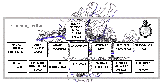
GENERAL PROJECT CHARACTERISTICS The goal of the Information System
is to permit the computerized management of all
activities associated with the Civil Protection Center.
This system is utilized in three different ways: first,
in calamity prevention (intervention planning, update of
available resources, event simulation, studies of
previous situations, etc.), second, during emergency
management (decision support, input of the various
aspects regarding the evolution of a calamity,
calculation of used resources), third, in the internal
management of the center (present personnel, internal
material resources, volunteer management).
After having defined the basic project requirements, the development was divided into the following phases:
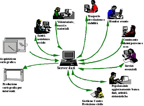
Some of the phases of the project are currently in the course of development, but will be completed before the Jubilee. This choice was made to obtain some short-term results in order to consent the verification of project decisions and the distribution of investments over time. In addition this allows the users to immediately begin system training as the other parts of the system are developed. GENERAL SYSTEM ARCHITECTURE The system consists of an IBM/AIX
central server which manages the alphanumeric database
and of a series of PC/Windows client workstations. One of
the client workstations currently manages the
cartographic database until a specific software is
obtained on the server to do so. One or more system
interface programs are installed on each client
workstation, each of which provides the specific
functions that are a part of each subsystem application. SYSTEM ENVIRONMENTS The system includes several operational environments which, apart from being perfectly integrated among one another, represent important specialized activities that must be carried out by the system. These environments, which have slight differences between themselves even among the functions established by the Augustus plan, are heretofore illustrated:
The organization of the system into
separate work environments allows each group of
specialized users to have available only the functions
developed specifically for their activities and placed in
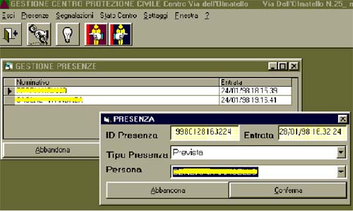
a personalized user interface. CIVIL PROTECTION CENTER MANAGEMENT The office registers the people present and lists every communication via radio, telephone, fax, etc. It’s necessary to register every able body in case of an imminent emergency. In addition, it can prepare, according to who is present, a correct plan of emergency for that certain assistance. A special electronic device aids in visualizing the procedure to follow according to the Augustus Method.
The act of recording every external
call or communication helps the center in two ways: one,
to act immediately with the intent of stopping the
phenomenon before it becomes a calamity, and two, to
verify the efficiency of the actions performed.
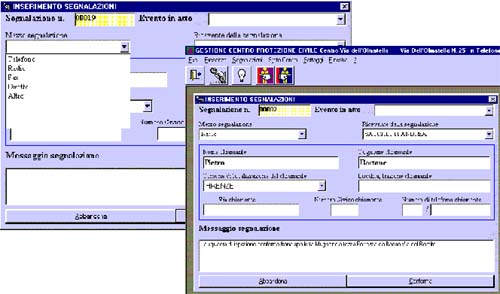
According to the information
gathered it is possible to define a phenomenon
"Event", if there is even a slight possibility
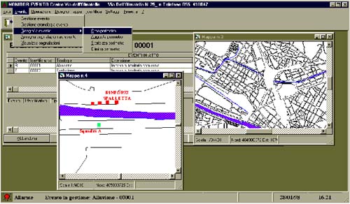
that it could become a "Calamity Event". EVENT MONITOR As a chess player can be involved
in more than one strategy contemporarily, the Civil
Protection Center, using its Computer System, can keep
under control more than one event, effecting what is
necessary at the time to control or stop it.
It is in this sector that the
system presents the maximum integration between the GIS
potential and the management function of the intervention
procedure.
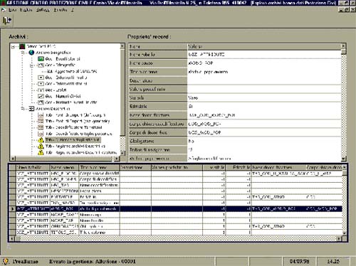
DATBASE CREATION AND UPDATE AND SYSTEM MANAGEMENT ACTIVITIES This environment includes all of the system management activities (database verification, user profile update, system catalog update) as well as the cartographic database update functions and external data import functions.
In addition the environment includes the following statistical functions regarding the center’s activities:
HEALTH AND SOCIAL ASSISTANCE The Center is able to manage the
relative data regarding the health sector. In particular,
it is automatically possible to have a list of hospitals
and social service centers within a proximity of the
disaster. EVALUATION OF DAMAGE TO PERSONS AND OBJECTS This sector deals with people and objects damaged by the disaster and evaluates the scope of the damage in general. This includes both private and public structures. The damage evaluation can be carried out on two levels: generally by looking at the damage on a broad scope and individually by considering each person separately. TRAFFIC AND ROAD CONDITION MANAGEMENT This environment, which is still in the development stage, will unite the functions necessary for managing the ambulance service to and from the disaster area as well as those for the transferring of the inhabitants to a safer area. The environment will provide network functions in order to calculate the most efficient route between two or more cartographic points enabling a greater efficiency in the transport of people unevenly distributed over the territory and guaranteeing a controlled flow of traffic towards hospital structures. ESSENTIAL SERVICES This environment will be capable of graphically visualizing points of service interruption in the water, gas, sewer and electric networks which will enable the user to determine areas without these services. CONCLUSION The system has currently completed its preliminary objectives and we are now planning to adopt several new and interesting extensions, oriented on one hand towards a general architectural enhancement (implementation of the SDE cartographic server based on the RDBMS Oracle) and on the other oriented towards an enhancement of the user services and functions provided by the system (weather prediction services, temporary hospital management functions, functions for communication with external agencies). |
     |
    |
 |
| [Introduction] [Conference programme] [Presentation by authors] [Presentation by category] [Poster session] [List of european Esri distributors] [List of exhibitor] [Esri products news] [Credits] |