Franco Ferrero
Regione Piemonte, Direzione Regionale Pianificazione e
Gestione Urbanistica, v. XX Settembre 88, 10121 Torino,
tel (+39-11) 4324160, Luigi.Garretti@regione.piemonte.itLuigi Garretti
Regione Piemonte, Direzione Regionale Pianificazione e
Gestione Urbanistica, v. XX Settembre 88, 10121 Torino,
tel (+39-11) 4324160, Luigi.Garretti@regione.piemonte.it
Marco Cavagnoli
CSI Piemonte, Settore Sistemi Territoriali,
c. Unione Sovietica 216, 10134 Torino, tel. (+39-11)
3168204, marco.cavagnoli@csi.it
Stefano Giorgi
CSI Piemonte, Settore Sistemi Territoriali, c. Unione
Sovietica 216, 10134 Torino, tel. (+39-11) 3168204, marco.cavagnoli@csi.it
Marina Grattapaglia
CSI Piemonte, Settore Sistemi Territoriali, c. Unione
Sovietica 216, 10134 Torino, tel. (+39-11) 3168204, marco.cavagnoli@csi.it
Abstract
The geographic
information system of Regione Piemonte is setting up a
series of data distribution services. In this paper we
present a prototypal application to display and query
data via the web. The application deals with urban plans
data of the regional Urban Planning Information System,
stored in a SDE database.
INTRODUCTION
The Sit (Sistema Informativo
Territoriale) of Regione Piemonte is a well-established
geographic information system used, since 1982, in order
to manage Urban and Regional Planning, Geological Survey,
Environment and Parks, Agriculture, Civil Defence and
Public Transport, to name a few of the better-known
regional government tasks supported by GIS. Services and
geographic information are available to the public, aimed
at the user’s technical, administrative and
decision-making requirements. The system has been set up
using Esri tools (ArcInfo, ArcView, SDE, MapObjects,
IMS).
Essential topographic information, as well as similar
information vital to land monitoring has been produced,
catalogued, integrated and updated since the
system’s introduction twenty years ago. The region
has been observed as a unique entity with its own natural
anthropical features. Its past and current topography has
been studied from both a descriptive and prescriptive
point of view, identifying its visible and hidden
characteristics at both a local and regional scale
(1:250.000, 1:100.000, 1:50.000, 1:25.000, 1:10.000) etc.
BEYOND THE DATA
Beside the traditional concept of
data per se, used in a local and corporative way,
the idea of shared data managed by various and composite
processes in territorial government is gradually
increasing and developing. It means that the first step
to take by public administrations is to publicize their
informative heritage to different kind of users. Up to
today the issue has not been completely achieved, because
it involves not only technical and organization aspects,
but cultural and institutional factors too. As a matter
of fact, the use of geographical information is rapidly
spreading, even out of its traditional application
fields, and data offer is increasing. Nevertheless that
does not automatically mean that any user can get useful,
meaningful and right information for his purposes.
In particular, government officials use GIS to support
decision making activities, so they generally do not need
raw data, but synthetic information, at different
processing levels. Data refinement, either in descripting
terms or in processing terms, is particularly important
in the well-developed cultural context of the Regional
Public Administration in Regione Piemonte: the more GIS
use is becoming a de facto standard way of
working, the more data interchange among local
departments and tools provided for it get crucial. Many
geographic data used and managed by a local
administration can be in fact very important to other
administrations too, even if they look at them from
different "points of view", according to their
knowledge domain. Therefore it becomes strategical to
promote and assure the proper data knowledge and
interchange, encouraging sharing and reuse to the
greatest extent. The Sit of Regione Piemonte provides
different tools to achieve the information discovery,
that is the ability to browse the metainformation about
the available data, and to identify the data of interest.
The main tools are: the Cartographic Inventory, the Sit
Access Interface and the Territorial Data Base.
The Cartographic Inventory is a tool for querying and
retrieving metainformation about available cartography
and related data, via Internet. The Sit Access Interface
is a tool for distributing public geographic data via the
regional geographic network: fully implemented with
ArcView and Internet Map Server software, it provides
advanced functions for spatial and thematic browsing. The
Territorial Data Base is a first level tool for querying
and displaying heterogeneous territorial data, based on
municipal areas, provided with simple statistical and
cartographical functions.
These tools have been designed for the sake of setting
the "unified work place", that is a general
access desktop service aimed at making regional officials
able to surf? all over the Regional Information System.
These general principles also inspire and regulate the
departmental Information Systems such as the Urban
Planning Information System: originally planned to meet
peculiar requirements, now they are developing towards
distributing, exchanging and integrating services for
data management in territorial government.
THE URBAN PLANS INFORMATION
SYSTEM CASE
The Urban Planning Information
System is a well-developed system in regards to the
storage of existing urban plans, based on municipal
areas. It adopts a specialized methodology for
standardizing urban plans, which has been improving in
the course of ten years.
In a few words, the methodology uses a series of
glossaries collecting in a gerarchical structure all the
prescribing rules which constitute the urban plan. Each
plan can then be disassembled in its primary and lowest
rules, stored in a coded format, related to geographical
zones within the municipality ("normative
areas"). The normative areas constituting the
geographical component in the Information System are
georeferred on the highest available cartographic data,
that is the Regional Topographic Map at the scale
1:10000. The disassembled plan can then be assembled
again, using GIS functions and capabilities, depending on
the peculiar user’s requirements, to perform various
type of analysis, produce new maps and processed data.
At present about 400 urban plans have been managed and
stored, covering the whole provinces of Turin and
Vercelli and parts of the other provinces in Regione
Piemonte, that is approximately one third of the whole
region (see fig. 1). The increasing system complexity
requires the information spread and distribution among
different administrative departments: for that purpose
CSI is setting up a series of various tools and services,
which are currently studied and undertaken for supporting
the regional administrative processes involving the urban
plans. The most important goal is to achieve the
integrated management of the whole information which can
be useful for checking an urban plan with reference to
neighbouring and overlapping plans, existing
environmental, cultural, geological constraints,
socio-economical data, etc.
THE PROTOTYPAL TOOL
A starting component of this tools
system has been implemented as a prototype, which is at
present restricted to data query. It has been planned to
be the lowest level means of knowing urban planning rules
and cartography. The prototypal application deals with
these features associated as items in a SDE layer of
normative areas, which can be represented using a
pre-classified thematic layout, with raster image of the
Regional Topographic Map as a geographical background.
The prescribing aspects are represented by two
fundamental features in urban planning: the predominant
use designation (residential, productive, agricultural,
tourist, natural and service areas) and the building
saturation degree.
The simplification level adopted in this prototypal
application is admittedly remarkable, compared to the
complexity of the information system, and the amount of
data at present has been reduced to a portion of urban
plans, just for testing: but the chosen scale and the
available functions meet the regional and provincial
requirements, that is the information level is suitable.
Moreover, as soon as all available plans are included in
an accessible form, the user will be able to query more
than 100,000 normative areas.
To make the maps reachable on the net, the application is
based on the following components:
- Web Server: Microsoft Personal
Web Server, supported by Arcview in Windows 95.
- Map Server: the Arc View
extent Internet Map Server and the Java Based
Applet Mapcaf�
- Browser: Netscape 3.0
The ArcView project includes the
following layers:
- raster background of the
Regional Topographic Map
- municipal and provincial
boundaries
- selection of municipalities
with stored urban plans
- boundaries of normative areas
- a thematic map of normative
areas, referring to a representative urban plans
classification
The following functions are
supported:
- zooming (in and out, next and
past) over the map
- panning over the map
- switching on and off the
displaying of available layers
- automatic selection in drawing
layers, depending on the scale
- interactive query on the
normative areas layer
- string search into the items
values
- map printing
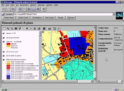
Fig.1 - Urban plans stored (July 1998)
|


