Maria Giovanna Martini
Servizio Sismico Nazionale (Italian Seismic
Survey), Via Curtatone 3, 00185 Roma, Italy, Tel
0039-06-44442546, Fax 0039-06-4466579, E-Mail: martini@ssn.dstn.pcm.it
Abstract
Within the scope
of data acquisition and data manipulation from the
different updated database relative to seismic risk
evaluation in Italy, we collected and made available, in
a consistency way, a lot of information in the SSN
databank.
The data bank created, has been structured with more then
70 vector data bases and 10 raster data bases.
INTRODUCTION
In March 1996 the GIS office of the
Italian Seismic Survey started a reconfiguration and
transformation project of all seismic data of the
National territory and their relative associated
information, stored in the existing information system.
The development of the project and its further functional
implementations, allows to accomplish the following
goals:
- a better access to the
information - a direct well organized
structure of the metadata make easier researches
and inquires;
- a better quality of the
data - the data are subjected to a detailed
verification of their accuracy, consistency,
precision and relative documentation, before
storing;
- a direct access of the
users to the data trough a dedicated and
friendly environment system for each kind of
user;
- faster access to the data –
data consistency and flexibility make them
immediately available for further implementation
or reports.
The project was born because the
Italian Seismic Survey, wanted to be conformed to the
A.I.P.A. (authority for IT in the Public Administration)
directives based on the study of feasibility for the
definition of a communication system of spatial data
through the Public Administration Network.
This project will also represent the contribution that
the Italian Seismic Survey will bring to the
"GEOSERVER project" of the Italian Department
for Technical Services.
The project has been divided in the following sub
projects:
- metadata: design and
development of metadata forms (at two difference
levels of detail) and of their query system;
- databank: design and
development of the databank including both
cartographic and standard thematic data;
- data management system:
manteinence and updating of spatial data, their
attributed and associated information;
- communication system: access
to spatial data and information from internal and
external users.
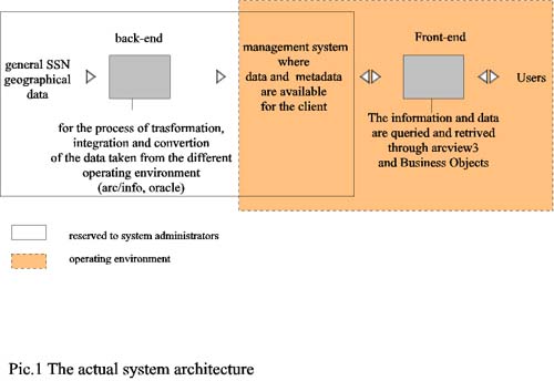
Picture 1 shows the actual system
architecture.
In the following paragraphs will be described the work
and the results of the "databank subproject"
which consists in a database collection of a remarkable
size, representing an efficient working tool for everyone
who wants to work in seismic field in Italy.
THE CARTOGRAPHIC DATABANK
With the "databank
subproject" has been developed the cartographic
databank dedicated to the study of seismic risk
evaluation in Italy. The data come from the National
Seismic Survey info system and they have been
restructured to be effectively used in the normal
information activities and in decision supporting system
during the seismic event management in "Crisis
Rooms".
The work for this subproject took two years, and it has
been articulated in different steps that they can be
briefly described hereafter:
- census of the national vector
and raster based cartography, or alpha-numeric
data stored in the National seismic Survey info
system;
- acquisition, from others
Public Administration Agencies, of other
important data necessary for the accomplishment
of our institutional duties;
- definition of the data minimum
requirements for the storage in the databank;
- definition of a descriptive
data-form both for vector data and raster data,
and consecutive filling of the same form for
those data which characteristics matched
requirements illustrated at point 3;
- design of the physical and
logical structure;
- data migration into the
databank;
- filling of metadata forms for
each database implemented (general description of
the database stored).
Among the database present in the
Italian seismic national system, only those falling into
the following requirements have been including in the
databank:
- they must describe the whole
National Territory with the same level of
accuracy from North to South;
- they must be certified, in
other words they have to come from an official
entity who can provide and state their
validation;
- they must have the necessary
data for further integration with other
databases.
For each of the validated database
suitable to storage, a form has been filled (a different
one from the metadata form) that sums up the cartographic
characteristics of each database, briefly describing both
geometrical and thematic aspects.
With the help of these forms the logical structures of
the data bank has been developed.
The databases have been organized by "concept"
; this include the relative information regarding the
format (vector/raster), the theme (argument described in
the data bases) and the scale of acquisition.
Such type of structure avoid sidetracking during the data
browsing.
Once taken a specific path to acquire the data, the users
don’t loose the awareness of the descriptive
parameters associated to the data, since those are always
carried with the information that is progressively
building up during the path.
This doesn’t mean that the path has to be strictly
prescriptive, but leaves the capability to access other
paths always organized with the same method.
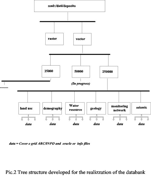
Pictures two shows the tree
structure developed for the realization of the databank.
The directories at the tree’s root display the two
big data "families" : the raster and the vector
families.
Going down the tree, the second layer encountered defines
the acquisition scale of the data.
Only three "families" have been considered and
consequently only three directory have been structured:
big scale, which includes data acquired with the scale
range between 1:10.000 (m) and 1:25.000 (m), medium scale
that includes data obtained with scale resolution ranging
from 1:50.000 to 1:100.000 and at last a small scale that
group all the data acquired at a resolution scale of
1:250.000 and below.
Descending further the tree, we find the third layer
which stores data according the theme that they describe:
for instance in the anthropic directory there are
databases that describe the transportation network
(roads, highways, railways, ..) developed areas, history
center, industrial areas.
Spatial data stored in the Italian seismic survey
information system, almost never were in the ArcInfo
format, often were ASCII files, or DXF files stored in
other operation systems different from UNIX (DOS, NT,
..). Otherwise, when they were already in the ArcInfo
format, most of the time they were organized in a
different way from the one desired (grouped by province
instead by theme with different projection systems).
Consequently the data bases implementation in the
cartographic databank, has required extraction processes
from their original O. S. , of cleaning with the
elimination of the redundant information and, in the end,
the transformation to ArcInfo coverages or grids with a
UTM zone 32. projection.
Each databases has been described both with a metadata
form (which contain information about its source
identification, its structure, units of measurement, and
its accuracy level) and a data dictionary where each data
element and its characteristics have been defined: name,
physic type, logic type, condition of existence, origin,
meaning of the codified fields, and more.
At the present time, the data bank include 77 databases
which each of them includes more databases (tab.1).
THE DATA BASES ACCESS
During the wait for the definitive
realization of the "access system" to the
information and data, which is under development with the
subproject named "communication system", we
provided to the internal user of the SSN (Italian seismic
service), a modular environment for data consulting that
allow to get from the databank the desiderate data and
also to manipulate them according to the various
user’s needs.
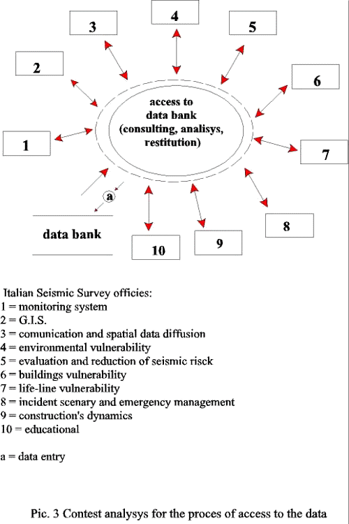
The contest analysis in pic. 3
shows how the SSN internal utilization demand is
extremely differentiated both for the requirements (in
every office the operative process and decisional process
are different) both for the different cultural background
between the same users (engineers, architects, geologist,
physics, …).
We have therefore chosen to provide a modular operative
environment that would allow the users, once terminated
the reading and definition of its own "work
project", the most possible flexible data bundle in
order to produce validated data.
The users have the capability of taking advantage of
their own professional skills: in fact is the user
himself that define the logic processes of aggregation
and data manipulation. The user is furthermore able to
change the logic processes regarding the intermediate
results obtained during the analysis process.
The "Esri arcview3" software system has been
chosen to access the databank.
The "Esri arcview3" software system allows to
access the cartographic data bases in its graphics and
alpha numeric elements: it provides both basic GIS
functions for spatial analysis and also the classical
DBRMS operators.
The access is allowed only in the reading mode: the
databank information can be retrieved and utilized, but
they can not be modified / edited neither new data can be
entered without the specific permission of the system
databank administrator.
In the next future, following the AIPA directives and
using the RUPA (Public Administration unified network),
the databank will be made accessible even also through
the consolidated technologies belonging to the
INTRANET/INTERNET architectures. In fact, upon
necessities, it will be possible to export data, using
the same technologies procedures of the WEBSERVER/ WEB
COMPUTING and the browsing interface type available from
different architecture system providers.
CONCLUSION
Within the scope of data
acquisition and data manipulation from the different
updated database relative to seismic risk evaluation in
Italy, we collected and made available, in a consistency
way, a lot of information in the SSN databank. A
cartographic databank containing almost eighty vector
data bases (more then 300 ArcInfo coverage)
geo-referenced to UTM zone 32 has been created.
Different tools for the access to the databank will be
available: a first layer of access, will allow the
medatata form reading, and will help the users in the
information research, in this way they will have a
detailed picture of all the data relative to the chosen
theme. Further access layers have been implemented for
different kind of users. These layers allow manipulation
of the data in order to produce thematic maps, tables,
and other data bases.
Some application, in the ArcInfo environment, have been
implemented for the decision supporting during the
seismic event management in "Crisis Rooms".
The databases stored in the databank can be used for
different tasks, therefore we hope that in the next
future the databank will be considered a valid working
tool for all the Public Administration Agencies.
|


