Paolo Ferrario
Institute of Agricultural Engineering,
University of Milan, via G. Celoria 2, 20133 Milan, tel
(+39-2) 23691476, fax (+39-2) 23691499, Paolo.Ferrario@unimi.itGiulio Senes
Institute of Agricultural Engineering, University of
Milan, via G. Celoria 2, 20133 Milan, tel (+39-2)
23691476, fax (+39-2) 23691499, Giulio.Senes@unimi.it
Alessandro Toccolini
Institute of Agricultural Engineering,
University of Milan, via G. Celoria 2, 20133 Milan, tel
(+39-2) 23691475, fax (+39-2) 23691499, Alessandro.Toccolini@unimi.it
Abstract
The rural
landscape planning and management needs an holistic
approach in order to achieve the new functions of the
countryside: not only a sustainable agricultural
production, but also recreation, landscape and
environmental protection, and in general a better
utilisation of the natural resources.
In this sense, we need methods and techniques useful to
asses and know the landscape resources, to determine
planning strategies for different levels (from the
national, regional or local planning scale to the site
design scale), to verify the impact and the level of
sustainability of the chosen planning strategies.
From this point of view, the GIS technology is a very
well known powerful tool.
Besides, the rural landscape represents, specially in
urbanised areas (i.e. metropolitan region of Milan,
Italy), the core of the "system of green areas"
and allows the connection with the urban green spaces. In
this sense, the rural landscape, characterised by the
presence of rivers and canals (natural or man made for
irrigation), of rural roads network, of rural buildings
with high historic and architectural value, can be
preserved and valorised by creating a greenway network.
The greenway concept, developed in the United States by
important landscape planners as Little, Fabos and Zube
among others, has been adopted by the U.S.
President’s Commission on American Outdoors (1987)
that recommend the creation of a "giant circulation
system based on a living network of greenways", and
is becoming now an international movement.
The greenways network, based on the development of
connected linear green spaces, allows a multi-function
planning of rural landscape – ecological,
recreational and historic-cultural – in respect of
the wider concept of sustainable development.
In this paper, are shown some new planning methods for
rural areas (EPP – Environmental Preconditions Plan
– method) based on the GIS technology, and are
presented the greenway concept as a new possibility for a
sustainable development of the rural areas.
GIS FOR RURAL LANDSCAPE
MANAGEMENT
The issue of land use knowledge and
of the guidelines for managing the processes that take
place throughout the landscape has turned out to be one
of the hottest topics of the last few decades, and is
being investigated with different methods and approaches,
depending on the disciplines involved.
In this connection, one interesting aspect relates to the
different meanings ascribed to the land use organisation
processes by the socio-economic disciplines, which
typically refer to "landscape programming"
(thus emphasising the identification of suitable
operational policies) as opposed to the
urban-environmental ones, which refer to "landscape
planning" (the emphasis being on the assessment of
the available physical resources and on the
identification of the most suitable development sites).
The differences between disciplines imply, furthermore, a
different assessment of the time variable with respect to
the possible effects of the proposed courses of action
(generally covering a longer time span in physical
planning).
These sectorial approaches, albeit vitally important and
typifying every specific discipline, are by now
displaying obvious shortcomings due both to the
increasing degree of complexity and interrelation of
landscape-related phenomena and to the necessity of
viewing the topic in a systemic perspective.
This statement applies in particular to the phenomena
that take place in a rural setting, for here the
interrelations with the subsystems located upstream and
downstream (technologies and production inputs for
agriculture on the one hand, and the food processing and
preservation industry on the other) are closer and, more
importantly, because the agricultural-forestry system is
often confronted with the need to implement
production-related decisions conditioned by market
pressures and directives issued by far-removed
decision-making agencies (the World Trade Organisation,
the EU, etc.) in areas with specific features and
constraints.
Said specificity calls for a holistic problem-solving
approach, which inherently implies suitable methods and
techniques for:
- investigating and analysing
the relevant phenomena so as to provide a brief,
yet exhaustive picture of such phenomena, that
can be continuously updated;
- pinpointing the planning and
project options that fit in best with the
different levels in land use management
(strategic-national, implementional-regional,
zoning-local, project-site);
- determining the impact of the
selected courses of action on the environment and
on the socio-economic context, as well as
monitoring and managing such courses of action
over time.
If the necessity is real, then the
GISs (Geographical Information Systems) may be the
key-tool to the implementation of an organic operational
and management policy for the agricultural-woodland
systems with respect to the different land-use governing
administration levels involved.
This appears to be particularly relevant, furthermore, in
view of the need to plan resource deployment most
carefully, so as to be able to assess the effects
(including long-term ones) of the implemented zoning and
production decisions on land use conditions and on the
environment. Otherwise put, it is a matter of testing the
"sustainability" of the decisions themselves.
This term, which has suddenly become so popular in the
context of scientific debate, emphasises the critical
importance of developing land use/landscape development
methods that will not jeopardise the future
generations’ ability to fulfil their needs.
The implementation of a far-sighted land-use planning
process implies, therefore, the use of suitable
methodological approaches supported by suitable
technological tools. On the one hand, the latter are
elicited by the new methods (based on the application of
parametric indicators and the overlay mapping techniques
for combining different thematic layers) (Fabos, 1992),
on the other they in turn provide an opportunity for
developing innovative methods, by making their
application possible (a case in point is represented by
the potential made available by remote sensing
techniques).
In this connection, the evidence seems to point to the
fact that, while the 1970s focused on agricultural
production issues and on the problems ensuing from the
scarcity of resources (this applies in particular to
energy sources), the 1980s were marked by the rediscovery
of environmentalist values throughout the population, a
process paralleled by the blossoming of planning methods
based on a new awareness of the environment. It is no
mere chance, in fact, that " landscape ecology"
methods – developed in some works produced in the
post-war years by masters such as McHarg (1969), the
seeds of which can be traced back to some studies
conducted in the 1950s (Troll, 1950) – should have
become widespread only in recent years. Another point
that deserved consideration, as an example of how new
technologies may influence or even suggest new
methodological ideas, is that an awareness of the
ecological relevance of landscape forms seems to have
sprung from a review of the first aerial photographs
(Zonneveld, 1990).
The unchallenged pre-eminence of the resource assessment
methods based on parametric indicators, along with the
related techniques for combining different thematic maps
(overlay process), has by now (1990s) become both
generalised and effectively operational in terms of
feeding new inputs to the planning process through the
use of information technology systems. In this context,
the terms "holistic" and "systemic"
take on a very real meaning, in that the decision-making
agencies in charge of land use and, more generally,
resource management at the different administrative
levels can rely on a clear, readily understandable tool
for choosing among the available uses of resources which,
by their very nature, are often finite and non-renewable,
if not at an exceedingly high cost for the community.
With reference to the foregoing, the following section is
devoted to an outline of the EPP (Environmental
Preconditions Plan) method, which has been conceived and
developed for application through the GIS.
THE EPP (ENVIRONMENTAL
PRECONDITIONS PLAN) METHOD
The EPP method derives from the
research carried out at the GIS/CAD Laboratory for
Environmental Planning and Design of the Institute of
Agricultural Engineering of the University of Milan
(Italy) into the validation of diverse methodological
approaches (on the various territorial scales) to the
definition of the directions to be taken in rural land
use planning processes and represents a synthesis of this
research.
The method was born out of the recognition that the
so-called "parametric" methods (ie.
METLAND, UET, etc.), introduced over the last two
decades, offer planners the opportunity to carry out
in-depth analyses of the environmental resources present
and consequently to define a more "rational"
use for them. Parallel to this trend, moreover, there has
been a general consolidation of GIS technology that
allows such methods to be applied with relative ease and
at reasonable costs.
The EPP method represents an attempt to define an
instrument capable of providing results through a
transparent procedure that is relatively easy to
comprehend, that can be computerised and that is
flexible, that is to say it is capable of automatically
providing new results with each variation in, or addition
to, the input priorities. The flow diagram of the method
is represented in Figure 1.
The method involves an initial
phase of analysis, and subsequent evaluation, of the
elements that characterise the territory and that may
condition its evolution. To this end, the method takes
into consideration both the elements that are part of the
"natural component" and those that belong to
the anthropic component, in that man and the environment
in which he lives and carries out his activities are
closely linked and evolve in a dynamic fashion.
These elements include:Territorial resources (e.g.
water resources, agricultural productivity, ecological
stability, the presence of elements of particular visual
quality etc.), the presence or absence of which
represents a stimulus or a restriction for development.Environmental
risks (e.g. pollution, flooding, earthquakes etc.)
that represent obstacles to the eventual anthropic
development of the territory.Elements that condition
development linked to both the anthropic and
environmental components. These include the current land
use, the presence of transport and technological
infrastructures that influence the costs of development,
the physical, topographical and climatic characteristics
of the area and the presence of features with
aesthetic-visual qualities that represent elements of
attraction. Then there are factors such as the existence
of land use plans and eventual financial or fiscal
incentives.
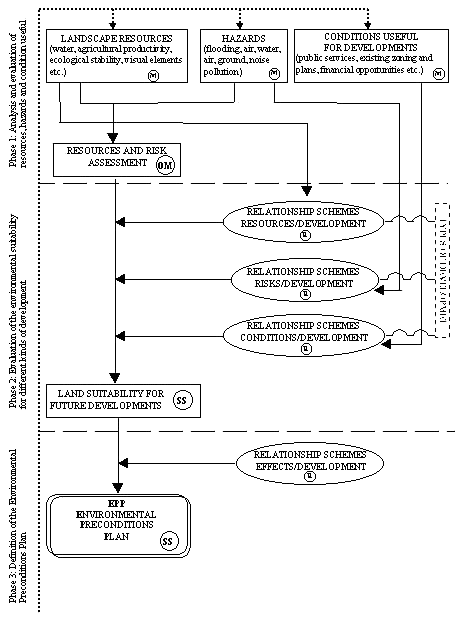
Fig. 1 - Conceptual framework of the EPP method
The result of this initial phase
represents an overall evaluation of the territorial
situation. The second phase involves relating all the
factors previously considered to the different kinds of
development possible in the area. In other words, this
means evaluating the suitability of the environment for
the proposed development through the drafting of
appropriate "relational diagrams" (Fig.
2).
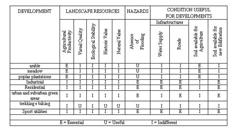
Fig. 2 - Relational diagram for evaluating the
environmental suitability for different developments
(scheme used for the application to the municipality of
Lodi in Italy)
In these diagrams the different
types of activity are placed in relation to the
resources, the risks and the elements that condition
development. The following elements may emerge:
- Essential elements, the
absence of which negates any possibility of
development.
- Useful elements, the
presence of which favours a possible development
that is not, on the other hand, necessarily
compromised by their absence.
- Indifferent elements,
the presence of which have no influence on
development.
By processing and aggregating the
results obtained from each diagram proposed, areas of
differing suitability for development can be highlighted
and therefore the most suitable in terms of the
availability of resources, the presence of elements that
condition the orientation of development and the absence
of risks can be identified. The end result is a land
suitability map for each type of development under
consideration.
A practical example of a map of zones potentially
suitable for the development of urban and suburban green
areas can be seen in Figure 3. In this case the method
was applied to the municipality of Lodi in Italy.
Prior to the definition of the zoning expressed by the
preconditions, the third phase involves an
evaluation of the direct and indirect transformations to
which the territory may be subjected as a consequence of
development, that is to say the potential side effects
that an anthropic intervention may have on the components
of the overall environmental system. The gravity of such
"environmental risks" depends on the severity
of the intervention and the characteristics of the
territory affected (in particular its vulnerability, its
importance to the man-environment system and its size).
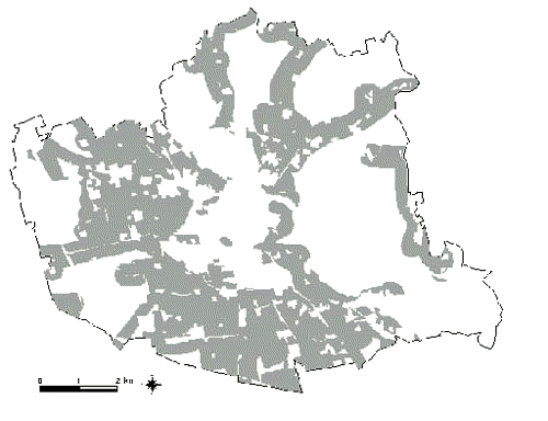
Fig. 3 - Zones potentially suitable for the
development of urban and suburban green areas
In order to carry out an evaluation
of the negative effects of the various types of
development on the environment it is necessary to make a
selection from amongst the multiple effects possible and
identify those which translate into a significant changes
in terms of appreciable increases in risks to the health
and well-being of the community and the alteration of the
resources involved that may compromise their future
exploitation.
The EPP method evaluates the various effects caused by
the development of human activities in relation to the
variable of duration, intensity and amplitude. It
should be pointed out that this analysis depends on the
supposition that each activity is carried out with the
best production and managerial technology available while
respecting the equilibrium between man and the
environment in which he lives.
The overall effect of a certain activity on a certain
territorial component is obtained by taking an overall
view of its gravity in terms of duration, intensity and
amplitude. As the extent of the negative effect
increases, the possibility of an area being suitable for
the localisation of the development in question
diminishes.
Developments that provoke permanent, significant and
widespread alterations have a greater overall negative
effect than an anthropic activity that causes temporary,
insignificant and localised negative alterations.
In order to identify the optimum location within a given
area for various kinds of development, the methodology
involves successive filtering procedures: the first
relational diagrams identify the most suitable areas in
terms of the availability of resources, the absence of
risks and the presence of elements that condition the
various types of development. Subsequent relational
diagrams (negative side effects/human activity) further
filter the areas identified previously and highlight
those in which the various developments have minimal
effects and therefore provoke minor alterations of the
resources present.
The result of the application of the EPP method is
represented by the Environmental Preconditions Plan
in which it is possible to identify the most
suitable location for each development under
consideration.
Figure 4 shows the
areas suitable for the establishment of urban and
suburban green areas in the municipality of Lodi.
Clearly, a characteristic of the method is that it is
able to assign different priorities to the use of
resources (depending on economic and social factors), and
therefore to be flexible in relation to the selection of
priorities imposed as the geographical and/or social
context changes. What is important is that the method
retains a procedural transparency.
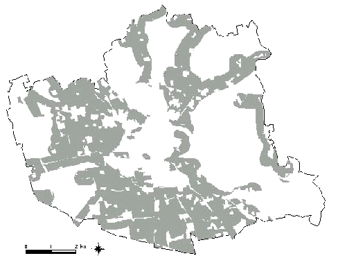
Fig. 4 - Areas
suitable for the establishment of urban and suburban
green areas in the municipality of Lodi.
THE GREENWAYS MOVEMENT
Over the last few years, especially
in highly urbanised areas, the rural landscape has
acquired growing importance within the more general
concept of the "greenways system", due both to
its function in protecting extensive open spaces against
urbanisation and to the role played by its outer fringe
in ensuring contact and integration with the urban
landscape.
The green system organisation models implemented in
metropolitan contexts in past years, such green-belts and
the so-called green-web, ascribe a basic function to
agricultural areas; in this connection, an interesting
experimental project was conducted also in Italy by the
Lombardia Regional Authority, with the establishment of
an agricultural park along the metropolitan belt (South
Milan Park), designed to safeguard and enhance the rural
landscape and its relevant productive, recreational,
environmental protection and landscape preservation
functions.
In addition, the rural landscape, thanks to the presence
of characteristic elements, such as the natural waterways
and the irrigation system (fig.5), the rural roads
network, the existence of rural buildings of major
historical and architectural significance, the lines of
trees and hedges, stands out as an essential form of land
use, an asset which is to be cherished and enhanced in a
sustainable development perspective.

Fig.5 - Province
of Milan, hydrographic network (canals data source:
Lombardia Region)
In this context, the establishment
of a greenways system may prove to be an effective
strategy. In the United States, the "greenways"
concept has aroused a great deal of interest among the
public at large following the publication of a paper by
the President’s Commission on American Outdoors
(1987), which looks forward to the establishment of a
"giant circulation system based on a living network
of greenways"; the concept itself has gained such
wholehearted support among outstanding landscape planners
(Little, Fabos, Zube) that it has by now become an
out-and-out movement. The greenways – linear green
areas – are designed to fulfil a number of functions
(in particular, ecological, recreational,
historical-cultural and educational ones) and are to be
viewed against the background of sustainable landscape
planning. In particular, greenways are characterised by
the following basic aspects:
- the space configuration is
essentially linear, the concept of movement is
inherent in the greenways model and sets it apart
from other models of organisation developed for
the green-area system. Moreover, greenways play a
role in connecting green areas to one
another, thus establishing a synergic link among
the existing landscape resources. In this way the
"non-linear" green areas become a
source of additional benefits rather than
facilities of lesser importance;
- greenways fulfil a number of
functions: ecological, recreational, educational
and historical-cultural ones.
The ecological function is performed
mostly by bio-corridors, involving natural
elements such as river ways and coastal belts,
where the conservation of the natural habitat and
the protection of the relevant species is of
major importance.
The recreational (or leisure-related)
function is performed by a number of linear
elements, such as country roads or routes cutting
across woodland, streets running along natural
and artificial waterways (hauling canals)
(fig.6), abandoned railway lines, which provide
the facility for crossing and connecting
outstanding areas both in terms of their visual
beauty and in view of the special significance of
the relevant animal and vegetable species; the
presence of sites of historical and cultural
relevance (often located along the waterways
which in the past acted as major communication
routes) emphasises the cultural and
educational role of greenways.
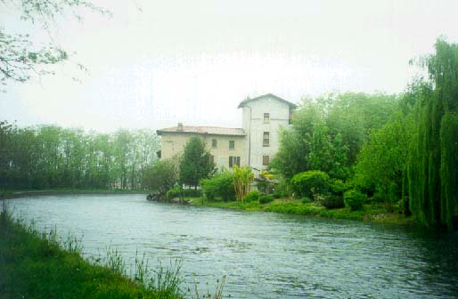
Fig. 6 - Example of greenway along an
irrigation-transportation canal (Naviglio Grande) (Photo
by A. Toccolini)
The main feature of such
greenways is to pursue multiple goals, even though a
greenway may be designed to fulfil a prevailing,
characterising function, depending both on the
available resources and on the specific targets to be
attained (which in turn depend on the users’
requirements). Also, greenways can be differentiated
according to their respective frames of reference
and, therefore, according to their scale (local,
national and supranational) (fig.7).
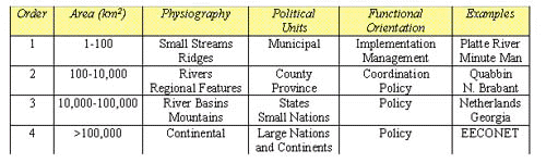
Fig. 7 - River Greenways classification based on
areal scale and associated attributes (from J. Ahern,
1995)
- greenways, as a landscape
planning and management tool, are consistent with
the concept of sustainable development, for not
only do they represent an effective means for
ensuring the conservation of natural resources,
but they also seek to achieve a balance between
resource utilization, as dictated by the existing
development requirements, and the protection of
said resources. In particular, greenways are to
be viewed as a "strategic landscape planning
concept based on the particular advantages of
linked linear systems" (J. Ahern, 1995).
Figure 8 (by the same author) shows some
"greenways planning strategies" ranging
from the mere protection and conservation of
resources (A and B) to more complex strategies
aimed at implementing a sustainable landscape
planning process as well as an effective
deployment of the existing resources (C and D).
The implementation of a greenways
system is a highly complex process, which involves
several steps, including:
- the definition of a
geographical information system covering a
number of basic aspects (hydrography, roads
network, altimetry, land use, administrative
boundaries) and specific areas of
investigation (protected areas,
hydrogeological hazards, soil
characteristics, vegetation, locations of
historical and architectural significances
etc.);
- an analysis and assessment
of the agricultural and environmental
resources, such as agricultural productivity,
visual quality, ecological stability, water
supply, woodland productivity etc.;
- the identification of
specific areas suited to the various types of
development and of areas which, by fulfilling
different functions, may provide a suitable
basis for structuring a greenways system;
- the implementation of
specific greenways projects with reference to
the legal aspect too;
- the effective management
of the greenways network in order to preserve
and sustain the implemented system; this
aspect relates to routine problems such as
the maintenance of the road network, of the
parking areas and the management of plant and
equipment (notice boards, road signs,
lighting systems, waste disposal bins). On
the other hand, such management includes all
the communicational aspects designed to
enhance the recreational and tourism-related
functions of the system: in this connection,
the problem of supplying users with proper
information proves crucial (information
concerning the routes, the sites of special
interest, the regulations governing access,
the accommodation facilities).
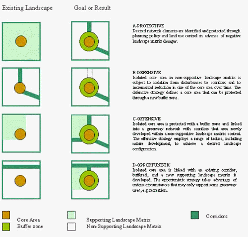
Fig 8 -
Greenways planning strategies (elaboration from J. Ahern,
1995)
Ultimately, the GISs seem to be
capable of making an essential contribution toward the
acquisition of basic data, the implementation of
data-processing procedures, the interrogation and
visualisation of the geographical-spatial and descriptive
elements involved in the greenways network and the
management of the system as a whole. Finally, as far as
communication and information to prospective users is
concerned, the employment of the GISs through the
Internet web offers considerable potential opportunities.
REFERENCES
J. Ahern, "Greenways as a
planning strategy" in Greenways, a beginning of
an international movement - J. Fabos, J. Ahern (eds.),
Elsevier, 1995, pp. 131-155
J. Fabos et al., Improved Land
Use Decision - Making in Rural Communities: Gis in the
1990s, Massachusetts Agricultural Experiment
Station Research Bullettin n. 739, 1992.
J. Fabos, "Introduction and
overview: the greenway movement, uses and potentials of
greenways", in Greenways, a beginning of an
international movement - J. Fabos, J. Ahern (eds.),
Elsevier, 1995, pp. 1-13
P.F. Fisher, R.E. Lindenberg,
"On distinction among Cartography, Remote Sensing
and Geographic Information Systems",
Photogrammetric Engineering and Remote Sensing, n.
55, 1989, pp. 1431-1434.
J. Kozlowski, G. Hill, Towards
Planning for sustainable development, Avebury, 1993
C.E. Little., Greenways for
America, The Johns Hopkins University Press,
Baltimore and London, 1990
I.L. McHarg, Design with Nature,
Natural History Press, New York, 1969.
G. Pellizzi, "Nuovi obiettivi
per l'ingegneria a servizio del sistema agro-industriale
del 2000", in General Report V Convegno Nazionale
Aigr, Potenza-Maratea, 7-11 june 1993.
E.M. Sorensen, "Agricultural
changes/changing agriculture - Some Danish experiences
and perspectives of multifunctional rural
management", in XX International Congress,
Melbourne, Australia, 5-12 march 1994.
A.Toccolini (a cura di), Analisi
e pianificazione dei sistemi agricolo-forestali mediante
GIS, Franco Angeli, Milano, 1998
A.Toccolini, G. Senes, "The
EPP method (Environmental Precondition Plan) for
sustainable rural land use planning, Atti del 13th
International Congress on Agricultural Engineering, Rabat
(Marocco) 2-6 febbraio 1998.
C. Troll, Die Geografische
Landschaft und ihre Forschung, Studio Generale 3, 45
Springer Verlag, Berlin, 1950.
I.S. Zonneveld, R.T.T. Forman, Changing
Landscapes: an ecological perspective, Springer
Verlag, New York 1990.
E.H. Zube, "Greenways and the
US National Park System", in Greenways, a
beginning of an international movement - J. Fabos, J.
Ahern (eds.), Elsevier, 1995, pp. 17-25
|


