Yrjo
Sucksdorff
Finnish Environment Institute, GIS and Remote Sensing
Unit, P.O.Box 140, FIN-00251 Helsinki Finland, tel
(+358-9) 40300643, fax (+358-9) 40300691, Yrjo.Sucksdorff@vyh.fi
Riitta Teiniranta
Finnish Environment Institute, GIS and Remote Sensing
Unit, P.O.Box 140, FIN-00251 Helsinki Finland, tel
(+358-9) 40300644, fax (+358-9) 40300691, Riitta.Teiniranta@vyh.fi
Abstract
Finland’s
Environmental Administration consists of The Ministry of
the Environment, The Finnish Environment Institute (FEI)
and 13 Regional Environment Centres. FEI is responsible
for the GIS in the whole administration. GIS is used to
give basic information for decision makers and
researchers, to describe and estimate the state of the
environment and to spread products which raise
environmental knowledge. The Environmental GIS can be
divided into the following parts: data, users, hardware
and software.
ENVIRONMENTAL GIS IS BUILT TO
SERVE THE WHOLE ENVIRONMENTAL ADMINISTRATION IN FINLAND
The Ministry of the Environment is
responsible for environmental policy and housing policy
and for preparing legislation. The Finnish Environment
Institute (FEI) is the centre for environmental research
and development. FEI provides expert services for other
environment authorities and for other customers. Regional
Environment Centres (RECs) are responsible for
environmental protection, land use, building, nature
conservation, protection of the built environment and use
and management of water resources in their respective
regions.
The Environmental Administration employs a total of 2200
people, of whom 310 work for the Ministry of the
Environment, 430 for the Finnish Environment Institute
and 1460 for RECs.
The variety of different tasks, the large area of Finland
(338 000 square kilometres) and the location of different
offices all over in Finland has given special demands for
the development of the environmental GIS.
DATA
The most important part of GIS is
data. The environmental GIS has about 12 Gb of raster and
vector data, which has been stored in the ArcInfo
databases. All databases cover the whole of Finland.
Scale varies from 1: 20 000 to 1: 1 million or pixel size
from 2 to 200 metres.
In Finland there are several GIS data providers, who
produce data having great importance for the
Environmental Authorities. A lot of this data has been
bought to FEI, for instance administrative boarders and
basic maps from National Land Survey and soil maps from
Geological Survey. Often the data bought does not fulfil
the demands of FEI, so a lot of efforts must be put to
reclassification, corrections, generalisation, topology
building, lay-out building etc. From the data bought also
new data is derived, for instance from DTM a hill shade
map.
When there is a need for data, which is not in digital
form, it is made in co-operation or by doing it self.
Land-use and forest classification from Landsat TM images
is an example of a co-operation product. There are many
advantages in co-operation: the costs are shared, wider
experience is in use and often the project can be
performed faster than when doing it alone.
Environmental Authorities are responsible for certain GIS
data production. The digitizing of drainage basins was
the first big GIS project at FEI in 1988-1990. The
digitizing was done with a Finnish software called Fingis
and later the data was transformed to ArcInfo. The
drainage basins and their sub-basins (totally about 8 000
basins) were delineated on 1:50 000 base maps and
digitized manually at FEI from these originals.
The numerizing of groundwater areas from 1: 20 000 base
maps was performed in the similar way, but now the work
was done at Regional Environmental Centres (RECs). The
project was co-ordinated by FEI. A lot of personal
quidance at RECs was needed.
In addition FEI has produced databases for protected
areas (about 2000 areas) and protection plans (about 2000
areas) in 1:20 000 scale and several other databases like
scanned general plans, skidoo tracks etc.
NATURA 2000 protection plan for Finland was numerized
with ArcView by RECs. The digitizing was done on-screen
using numerical base maps and real estate boarders as
background data. This was the first great GIS project
done with ArcView. Because of this project the use of
ArcView was doubled at the Environmental Administration.
At the same time the strong and weak points of
desktop-GIS were found. For this application, a special
ArcView user interface was built.
The most important ready to use national databases are
listed in Table 1. These databases are located on
FEI’s GIS server from where everybody at the
Environmental Administration can use them. Regional
Environment Centres have copied most of these databases
to their own NT-servers because the line speed between
FEI and RECs is not fast enough to transfer continuously
big databases.
Table 1. ArcInfo DATABASES AT
FINNISH ENVIRONMENT INSTITUTE (the most important ones
30.8.1998, covering whole Finland)
| Data |
Scale |
Format |
Source |
| Administrative bound |
1:100 000 |
Vector |
NLS (Nat. Land Survey) |
| Watersheds |
1:50 000 |
Vector |
FEI (Finnish Env.
Institute) |
| Sea area division |
1:50 000 |
Vector |
FEI |
| Shorelines |
1:20 000 |
Vector |
NLS, FEI |
| Lake names (56 000 names) |
1:50 000 |
Point |
FEI |
| Groundwater areas |
1:20 000 |
Vector |
FEI |
| Protected areas |
1:20 000 |
Vector |
FEI |
| Protection plans |
1:20 000 |
Vector |
FEI |
| NATURA 2000-plan |
1:20 000 |
Vector |
FEI |
| Soil |
85m*85m |
Raster |
Geol. Survey |
| Land use and forests |
25m*25m |
Raster |
NLS |
| Elevation |
25m*25m |
Raster |
NLS |
| Elevation |
1:20 000 |
Vector |
NLS, FEI |
| Base maps |
2m*2m |
Raster |
NLS |
| NOAA AVHRR images |
1km*1km |
Raster |
FEI |
RECs have also a lot
of their own databases. These databases have only local
usage in the area of each REC. If the database has
national interest, each REC sends a copy of it to FEI,
which is responsible for nation wide databases.
All databases are described on the Intranet. The contents
of these pages are described in Table 2.
Table 2. THE CONTENTS OF INTRANET
PAGES WHERE GIS DATA IS DESCRIBED
General information
Database name and a short
description
Original scale
Coordinate system used
Coverage
Who has made the database
Who has copyright
Updating
Contact person
An example of the data (an image)
Coverage name and address in the NT
servers hard disc
Technical information
Polygon attributes and their explanations
Line attributes and their explanations
Region attributes and their explanations
Point attributes and their explanations
A lot of environmental data has
been collected to relational databases. The Environmental
Data System (EDS) contains over 35 million individual
observation measurements and identifications of
chemicals, climate change, hydrology, water quality, etc.
Most of these databases are geocoded so they can be
combined and checked with GIS data. The ArcView extension
has been built to check that the coordinates of
observation points are correct, to make coordinate
transformations if necessary and to make analysis to
check other attribute data in the registers like the code
of municipality, lake code, drainage basin code etc.
GIS SOFTWARE USED
The basic GIS-software is ArcInfo
(9 unix-licences), which is mainly used for database
management and analysis. ArcView is used as a user
interface to ArcInfo databases from all of the
aforementioned environmental offices spread troughout
Finland. There are more than 150 ArcView licences
connected to the network. ArcView is used for producing
GIS-data, creating maps and for making light analyses.
The special user interface has been built to facilitate
the use of environmental GIS. When using this extension
the user chooses interactively the area of interest:
whole Finland, REC, municipality, map sheet, drainage
basin etc. The user interface makes a view with suitable
background map information. The user can add more data
from a pop-up menu, where all common databases are
listed. When zooming in or out in the view, the user
interface searches the best background data. Several
other ‘buttons’ have been implemented to the
user interface to help the usage of ArcView, for instance
a new print button to facilitate the layout production.
USERS
FEI has a GIS and Remote Sensing
Unit, which is responsible for all the basic GIS actions
at the Environmental Administration, like general GIS
databases, user interfaces, software management, etc.
This unit takes also part to major GIS projects. For the
basic GIS work there are three persons, and for GIS
projects six.
Very much attention has been paid to co-ordination and
functionality of GIS. General GIS information is
exchanged by the GIS users network, wherein belongs one
person from every unit of the Finland’s
Environmental Administration. The network acts via e-mail
and discusses at Intranet. Annual meetings with other GIS
users are also arranged. All GIS information and hints
are put to the Intranet open to all users.
ArcView support is arranged through ArcView contact
persons. One person in each REC and one in each
department of the ministry of environment and FEI belongs
to this network. If the contact person cannot solve the
ArcView problem he contacts FEI’s ArcView support.
If FEI cannot solve the problem, the question is further
sent to the local ‘Esri dealer’, with whom FEI
has a support contract.
The GIS is co-ordinated at the Environmental
Administration by a GIS steering group. This group makes
decisions of supported software, database buying,
arranges user meetings, makes the general yearly GIS
action plan etc.
Every ArcView user gets two days of ArcView basic
education. The students are using during the course
FEI’s own data, so they familiarize with the data at
the same time. Several other GIS-courses have been
arranged like 'GIS-basics' and 'GIS-database building'.
FEI’s GIS is responsible for these activities.
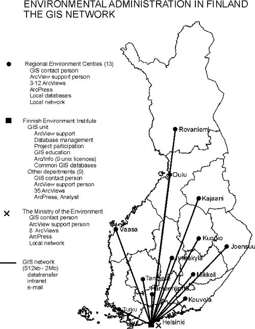
GIS-network is shown at the Appendix 1.
EXAMPLES OF GIS USE
GIS is more and more used at
everydays work at the Environmental Administration. The
user interface is used for numerizing new data like
protected areas, NATURA 2000 network, protection plans,
groundwater areas, dump sites, skidoo tracks etc. Several
major projects utilize the user interface: GIS for
regional use (planning, exceptional permits, cultural
environment etc.), water quality maps for Finland,
databank for recreation areas, realization plans for
protected area plans etc. MapObjects and Internet Map
Server are used to build a graphical user interface to
observation registers.
GIS is widely used for different analysis: Soil, land
cover, DTM and drainage basin layers are combined and
analyzed together to calculate input variables for
nutrient loss model, GIS is used in hydrological
modelling (evapotranspiration, flood forecasts, flood
zone estimation), biodiversity calculations, etc.
Map production is an important part of the GIS at the
Environmental Administration. FEI alone has made more
than 10 kilometers of A0 wide maps this year.
CONCLUSIONS
At the Finland’s Environmental
Administration the use of GIS has enlarged very much
during last five years. The first ArcView was purchased
in 1994 and now we have 150 licences at the environmental
offices spread throughout Finland. Desktop GIS has proven
its usefullness in several projects and it will be
utilized much more in the near future.
Anyhow there are several facts that hinder this
development. There is always need for better data; better
quality, better accuracy, better scale,… Sometimes
even if the data exists, it is too expensive. Often the
data needs much improvements, because it is made for map
production, not for GIS analysis.
Often the users do not have proper GIS education, so they
are not capable to utilize the software and data in the
best way. Much attention should be paid to general and
specific GIS cources and utilisation of the software.
All tasks are not possible to do with a standard ArcView
– the more people use ArcView - the more they want
to do with it. The solution for this is to buy some extra
modules to ArcView or to order the job from FEI’s
GIS unit, which is using ‘heavier’ software
than a desktop GIS. Both ways are expensive and often too
much time consuming.
The Esri softwares are expensive and so are the updates
and supports, too. The update and support policy of Esri
and its dealers is unclear. This makes it difficult to
make long term plans how to develope the environmental
GIS in Finland.
APPENDIX 1
|


