|
| NAZCA: THE SOIL INFORMATION SYSTEM FOR SOIL QUALITY MANAGEMENT |
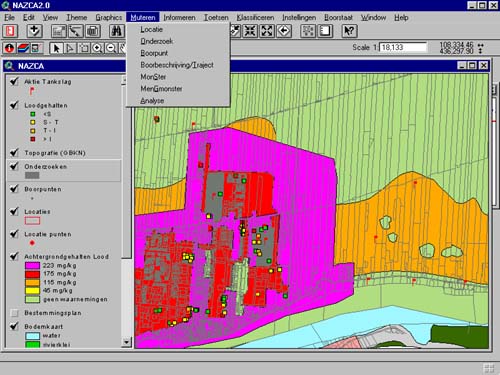
| Marieke Van Der Meulen CSO Consusltants for Environmental Management ans Survey, Regulierenring 20, 3981 LB Bunnik, The Netherlands, tel (0)30-6594321 fax (0)30-6571792, m.meulen@cso.nl Abstract NAZCA, a Soil Information System based on ArcView and Oracle, enables the user to store, retrieve, and view soil quality data with an easy to use user-interface. The use of ArcView makes it easy to combine and analyse the soil quality data with data on other subjects as for example landuse, geomorfology, city-development, historical soil pollution, cables and wires or building plans. By means of statistical tools soil quality and soil pollution can be characterised or predicted. The soil quality can be presented in tables, maps or cross-profiles. The functionality of NAZCA gives the user ready-access to the soil data on a specific location. Thus questions about the availability of soil information and the soil quality situation on a location can be answered fast and easy. The functionality for data-retrieval and viewing of specific information on, for example, certain areas, soil quality parameters or pollution levels enable the user to get a spatial insight in the soil information and regional differences in soil pollution. And last but not least information on soil, soil quality and pollution can be analysed in combination with other spatial data and thus in an early stage incorporated integrally with other types of information in the development of complex plans and the taking of far-reaching decisions. INTRODUCTION For some time Soil Information Systems (SIS) have been used to store, analyse and present soil quality data. With the introduction of the concept of soil quality management and the resulting changes of the role of government authorities, the requirements of a SIS will change. Thematic thinking about soil will make way for thinking in terms of soil management. The relation between different cases of contamination mutually and their environment will draw more attention. To an increasing extend information on soil quality will be exchanged. Also more information of a different nature will be exchanged between the various administrative levels and social actors. Based upon the information on soil quality radical plans will be made and far-reaching decisions will be taken. The structure, content, and functionality of Soil Information Systems will have to be adapted to enable us to attune ourselves to this new approach. INCREASED INFORMATION FLOWS After some time of soil decontamination efforts, it has become obvious that soil contamination is a structural problem, which can lead to the stagnation of social processes. To think in terms of management measures and target objectives is the logical consequence of thinking in terms of thematically processing a finite list of decontamination cases. This new manner of thinking will lead to an increase in the intensity of the information flow and changes in the nature of the information exchanged. The organisational sectors of provinces and municipalities that are concerned with soil contamination will position themselves more and more emphatically as offerers of information. In the planning phase of housing construction and natural development projects, for example, various social actors will pose questions about soil quality management and the (financial) consequences. These same organisational sectors of provinces and municipalities will then also require more information: information, for example, about the history, the geomorphology, the soil composition, the hydrology etc. of diffusely contaminated areas. Shortly, information which is needed to require a project-boundary-surpassing insight into the causes and consequences of structural soil contamination and the correlation between cases of contamination. Figure 1 OPEN STRUCTURE NECESSARY Translated into the demands which are made on a SIS, this increase in information flows means that an open structure is called for: the SIS must be exceedingly flexible in its acceptance and provision of data. Functionality in terms of retrieving and interpreting data and derived information may not restrain the contents of the SIS. NAZCA, based on ArcView/Oracle, offers you very extensive possibilities to read different sources of data. Just a few examples: AutoCAD drawings, Intergraph files, Cadastral files, Provincial files, company files, etc. This makes it possible to link up your SIS seamlessly with available data files and existing systems, minimising your input work and giving you immediate access to a well-stocked SIS immediately after installation. A SELECTION FROM THE NAZCA DATABASE On account of its open structure the user is free in completing the NAZCA database. The following example gives you an impression of the possible contents: Basic maps:
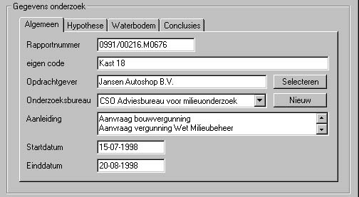
Site data:
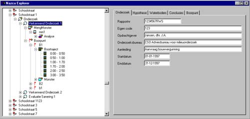
Figure 2 Project data:
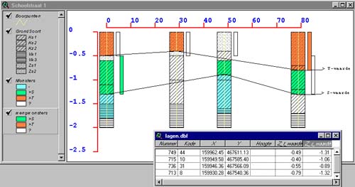
Soil data:
Soil chemistry:
Figure 3 SURPLUS VALUE NAZCA The most important surplus value of NAZCA is the fact that it is completely developed out of a GIS concept by making use of the desktop GIS software ArcView. By this it distinguishes itself from other systems which are developed from a database concept. In technical terms this means that the more traditional systems make use of a database upon which a "map generator" is placed in order to map the data. NAZCA, on the other hand, proceeds on the basis of the spatial (geographic) relationships between the various elements. In this way one is not limited by the system in terms of the nature and content of the data you wish to include. This means, for example, that the spatial relationship between a sample location or a research area, and the location of a building or cadastral parcel, is automatically registered by NAZCA as soon as the information is added as a map layer. In a system based upon a database these relationships must all be administratively recorded. By proceeding on the basis of the GIS functionality, the retrieval of overviews is no longer location-dependent but can, inspired by soil quality management, surpass the limitations of location and take place integrally. INTERCHANGE OPTIONS Since NAZCA is constructed in a system which conforms to the Open Geodata Interoperability Specifications, automated interchange with systems such as ArcInfo, AutoCAD, and Intergraph is guaranteed. In addition, data files can be interchanged with all current database systems. Similarly digital large-scale basic maps can be used without any difficulties. Various government authorities have chosen ArcView/ArcInfo as the standard GIS solution, which means that interchange with these organisations, where necessary, can take place without complications. USER-FRIENLINESS NAZCA is programmed completely in the Windows environment and makes use of all top-quality applications offered by this operating system. NAZCA offers a high degree of user-friendliness, and the system's logical structure and operation makes it easy to work with. No more complicated conversions from the database to graphic software in order to draw maps but, instead, mutually-integrated functionality. Within one and the same system, data can be entered, retrieved, processed and interpreted to be, eventually, placed on paper in the form of maps and/or graphs. Figure 4 NAZCA: THE BASIS FOR SOIL MANAGEMENT
NAZCA TECHNICAL SPECIFICATIONS NAZCA is developed in Avenue, the object-oriented programming language of ArcView, and Visual C++. Because NAZCA proceeds on the basis of ArcView, it also possesses the overall GIS functionality of ArcView. Geographic objects are stored as SHAPE files. Because the Shape format is documented, it is also possible to use Shape files created with NAZCA with other types of software. The administrative data in NAZCA is stored in a Relational Database Management System (Oracle). One can work with a stand-alone database or in a client-server (DOS/Unix) environment. To obtain an optimal connection with existing geographical files, within NAZCA one can work with GIS data in formats such as ArcInfo, MapInfo or CAD files from for example AutoCAD (the DXF and DWG formats are supported), and Microstation (DGN files are supported). ArcInfo coverages, DWG, DXF and DGN files are directly - i.e. without conversion - imported. In addition a large number of grid formats such as TIFF, GIF, BIL, ERDAS, and JPEG are supported, which makes it also possible to work with scanned topographic backgrounds. Geographic data can be exported as Shape files or ASCII files. Administrative data can be exported as Dbase or ASCII files. Any Windows-supported printer or plotter can print the maps, tables and graphs created using NAZCA. In addition prepared maps, tables and graphs can be stored as Encapsulated Postscript files (EPS), and in CGM or PCX format. NAZCA: THE DEVELOPERS NAZCA is a product of CSO Consultants for Environmental Management and Survey and Esri Netherlands. Esri Netherlands is the official Esri distributor in the Netherlands. In addition it provides total solutions in Information Technology projects, making use of products and expertise in GIS and various GIS training courses. CSO Consultants for Environmental Management and Survey is an independent, medium-sized consultancy group active in the field of environmental issues. It provides services in the following areas:
In its role as partner CSO supports its customers in initiating and formulating new developments in the environmental field. Projects are executed by interdisciplinary project teams composed of numerous experts providing mutual support and reinforcement. By approaching issues from a various points of view, it is possible to find the optimal solution. An integral view of environmental aspects and spatial relationships, whether global or regional, is the main objective. This is one of the reasons why the use of GIS plays a crucial role in CSO. The analytical and spatial functionality is a valuable and powerful instrument in a veritable plethora of research. The knowledge of the specialists is always up-to-date, enabling them to provide advice in a wide range of top-level GIS applications in environmental survey. |
     |
    |
 |
| [Introduction] [Conference programme] [Presentation by authors] [Presentation by category] [Poster session] [List of european Esri distributors] [List of exhibitor] [Esri products news] [Credits] |