|
| GEOGRAPHIC INFORMATION ON THE WEB - PROBLEMS AND SOLUTIONS |
| Paolo
Mogorovich CNUCE - Institute of Italian National Research Council, Via S.Maria 36, 56126 Pisa, tel. (+39- 50) 593234, fax (++39 -50) 904052, e-mail: P.Mogorovich@cnuce.pi.cnr.it Pietro Pizzo Olga Renda Abstract Geographical metainformation is quite a neglected resource but is the basis for a greater use of existing geographical information. From a commercial point of view it is also an excellent stimulus for the development of service, data and product markets. Metainformation is indispensable for users as it allows them to find out the existence of geographical data along with their content and quality; and suppliers can learn about the quality of data produced and publish it. This work analyses various scenarios in which suppliers and users are related via different organizational solutions. There are thus different constraints with regard to technical solutions. Finally, a new product in a prototype form is presented. It enables effective searches for geographical data on the Internet, using both geographical and alphanumerical criteria. The constant alignment between the data and the relative metainformation along with the use of a standard for the metainformation are shown to be critical elements in this sector. INTRODUCTION While some years ago GIS users were forced to acquire data using a digitizer or other devices, most data can now be obtained from data providers which offer the data they have, using Internet facilities as well as local networks. The role of the metainformation is critical for anyone who needs to use acquire geodata. Metainformation is used to check for the data and its technical characteristics and, if a standard is used, it can be used to easily compare data offered by different data providers. From the point of view of the data provider, the need to produce metainformation is an opportunity to gain more awareness of the data to be offered. Users and suppliers of geographical essentially have the following requirements
For general processing needs users have a number of requirements: What data exists? What technical characteristics does the data have? How much will it cost? etc. USER NEEDS IN VARIOUS ORGANIZATIONAL SCENARIOS
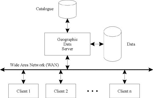
The four scenarios require different types of catalogue management (centralized, distributed, local) as outlined below. A good software tool for documenting data and for spreading the metainformation should not necessarily impose a particular type of organization, but should be able to link up various scenarios (particularly as from an organizational point of view everything is constantly changing). THE GEOGRAPHICAL DATA SERVER The last few years have seen the emergence of a number of Geographical Data Servers (GDSs). GDSs are client-server systems for the search and retrieval of geographical data. Figure
1 General architecture of a GDS GDSs can be divided into Map Servers, that create geographical maps on the basis of user indications, and Data Servers, that supply the user with a set of data that can be used by a GIS. There is a hybrid in which geographical information is sent in vector format and the client processes it by defining or modifying his/her own map and possibly printing it. In this case both the typical functionalities of a Data Server and an Map Server are present together - though often with limitations. State of the art GDSs have a catalogue on which searches can be made on the characteristics of the data. The catalogue contains the metainformation, i.e. the descriptors of the data. There are also Metadata Servers that only contain the catalogue of the data but which don’t allow access to the data itself. PUBLICATION OF METADATA Each data producer can have one or more catalogues that describe the geodataset that the producer intends to publish. A catalogue may be:
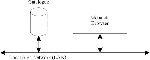
In the three cases the operating condition of the end user and the procedures to mantain updated the metadata are quite different. Figure
2 In a local catalogue the metadata is stored at the
user. Figure
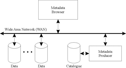
3 In a centralized catalogue the metadata on a specific
theme are all stored in the same place. Figure
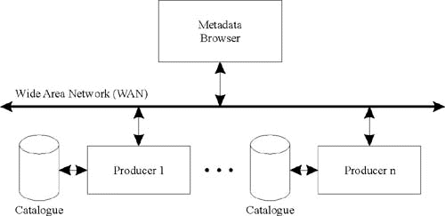
4 In a distributed catalogue the metadata is distributed
on the network and is generally grouped together where
the geographical data it refers to is stored. SOCRATE Socrate is an Italian project designed to create a system that allows users to document and distribute geographical information using EU norms. The project is partially financed by the Tuscan Regional Adminstration. The system is being developed by Sistemi Territoriali. The other participants (local governments, agencies and industries) are involved as potential users of the system, either as producers of geographical archives or as end users. Socrate allows:
Downloading of geographical data is foreseen. The functionalities operate under Internet/Intranet and respect the european norms. Socrate allows both downloading and data processing. It enables geodataset catalogues to be generated, managed and consulted. In addition, thematic maps can be defined and inserted into catalogues, interactive maps can be composed and printed or print files generated. The catalogue is a set of descriptors of geodatasets (GDDs) that describe the geographical data. The catalogue contains and organizes the descriptors thereby making them visible and accessible in consultation by a browser. The catalogue of geodatasets also contains information on the organizations that distribute the data (public bodies or companies). Figure
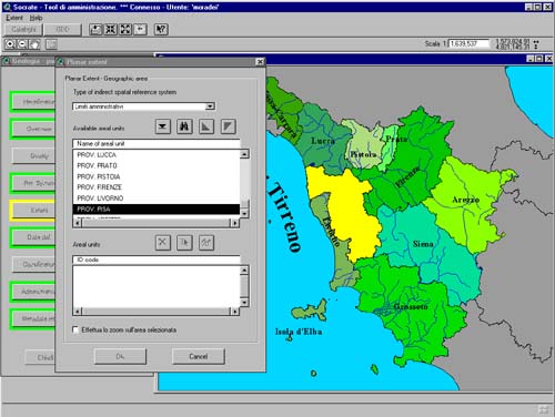
5 The 'MetaEntry' module allows the distributor to
prepare and update the catalogue. Figure6
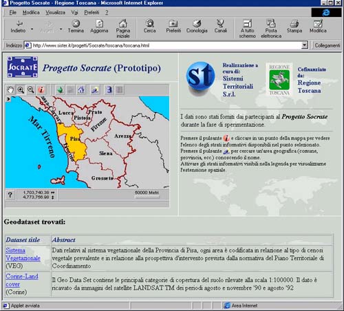
Consultation interface on Internet The end users of the system access a catalogue on Internet/Intranet, navigate it and make queries until they can find the data they need. To find out the area of interest, they can zoom and pan onto the reference maps. Predefined thematic maps, aimed at specific groups of users (e.g. waste disposal, marketing) may be described within the catalogue and classified on the basis of the user categories to which they are dedicated. Access to the catalogue is via two types of client: an Advanced Client (only available on LAN) and a Light Client, available on Intranet/Internet, which has simplified functions but only requires the use of an html standard browser (Netscape or Internet Explorer). The system is designed for three types of users: end, distributor, administrator:
The fundamental element in the system is the catalogue of geographical data which contains and organizes the metadata and makes them visible and accessible in consultation by a browser. The system allows management an official catalogue, accessible via navigation and query to all users, and several working catalogues. Each distributor works on his/her own working catalogue. The administrator can decide which GDDs will be published in the official catalogue, while distributors can create and define the GDDs. FUNCTIONALITIES Catalogue creation. Catalogues are created by the administrator. When created, a set of parameters and predefined values is defined which will then be used during the definition of the GDDs with the reference system in which the planar extents of the GDDs are defined along with the reference map, the gazetteer (see next paragraphs), and the thesaurus. Reference Map Management. Each kind of user can tailor the reference map so as to display only those information layers that are of interest or to add other information layers. Thesaurus Management. The administrator defines the thesaurus that will be used by the distributors to classify the geodataset, and by the end users to navigate the catalogue by topic. Gazetteer Management. A gazetteer is a list of geographical areas with an associated name. The gazetteer is used to set the extent of the GDDs indirectly. Gazetteers are also indicated so that users can position themselves on the reference map by giving the name of the area and to identify which GDDs concern that area. The system allows users to query the catalogues spatially on the basis of the gazetteer. Populating the Catalogue. Each distributor populates his/her own working catalogue. The functions for populating the catalogue allow for extracting information directly from geographical data. Some fields of the metainformation can be filled in by choosing a value from a list of predefined values, e.g. organization, people, roles, reference systems, type of support. The GDDs produced by the distributors are collected and organized by the administrator. The administrator can use exporting functions to extract a part of the catalogue and send it to other organizations or to integrate in his/her catalogue GDDs that come from other organizations. Metainformation extraction. The system allows users to automatically extract the planar extent from the geodataset along with the classes of object and for each the geometric primitive used and the attributes. Publishing catalogues on the Web. Publishing the catalogue of data consists in making available on the Web the reference map of the catalogue, the gazetteer, the thesaurus and the GDDs so as to be able to carry out queries and consultations via an html standard browser. The consultation of the GDDs is organized on two levels. The first level (light metainformation) presents the user with all the 'salient' basic ??? information on the data. The second level presents in hypertext all the information set forth by the norm. Accessing Catalogues. Access to catalogues takes place via two types of client: advanced clients, available on LANs and light clients, available on Intranet/Internet which has simplified functions, but only requires the use of an html standard browser. There are two possible types of access to the catalogue - by navigation (by topic or geographically) or by query. Users are guaranteed both types of access. Navigations and queries can be nested to obtain increasingly restricted GDD lists.
A sample of the geographical data can be displayed so that users can assess whether the data will really be useful for them. Access to GDDs - After obtaining a list of GDDs, it is possible to explore the metainformation contained in the GDDs to verify that the geodataset described really contains the desired information. Creating predefined maps. It is possible to choose a set of information layers and join them together in a map by associating with each information layer the appropriate legend for the type of map. The map thus created is added to the catalogue and described like any other geographical data. Generating catalogues in RTF or HTML - Generating catalogues in RTF or HTML is an alternative tool for the divulgation of the catalogue for remote users that don't have an Internet connection. BIBLIOGRAFIA
|
     |
    |
 |
| [Introduction] [Conference programme] [Presentation by authors] [Presentation by category] [Poster session] [List of european Esri distributors] [List of exhibitor] [Esri products news] [Credits] |