|
| ARCHIE: A WAY TO EASILY MANAGE, BROWSE AND QUERY AERIAL-PHOTO ARCHIVES |
| Paolo
Mogorovich CNUCE - Institute of Italian National Research Council, Via S.Maria 36, 56126 Pisa, tel. (+39-50) 593234, fax (+39-50) 904052, e-mail: P.Mogorovich@cnuce.pi.cnr.it Gianluca Fagiuoli Olga Renda Abstract The photographic documentation of the earth is one of the most interesting and substantial collections of information in the history of mankind. Aerial photographs and remote-sensed images document in great detail the evolution of the presence of man and the environmental variations of this century. This vast heritage is often under exploited (especially aerial photographs) due to the difficulty of finding access to the necessary material. Archie is an ArcView application that allows the creation, management and consultation of descriptors of aerial photographs and remote-sensed images. Its main characteristics are firstly the capacity to efficiently manage vast quantities of data, and secondly a particularly user friendly interface. Archie was developed specifically for this purpose and thus meets the special needs of this sector. In carrying out our study of the characteristics of the material treated, the definition of the data model and the analysis of the acquisition and consultation processes, we made great use of the experience gained by the "Laboratorio per la Fotointerpretazione e l’Aerofotogrammetria" of ICCD, Ministry for the Cultural Heritage (Rome, Italy). AERIAL PHOTOGRAPHS An aerial photograph is an image of the land taken from an aircraft or aerostat. In an aerial photograph one can simultaneously observe a vast quantity of objects in a particular area with respect to what we can normally see - this vision is known as synopticity. Although what we present in this work derives from specific work in the field of aerial photographs, our comments and solutions are nevertheless valid for remote-sensed images from satellites. Aerial photographs are generally taken for use in cartographic documents, however, once this first and main task has been exhausted, aerial photographs will continue to live as tools for documenting the past. The first aerial photographs were taken at the end of the nineteenth century. Since then photographic techniques and products have become more and more sophisticated. Consequently there is quite a bit of variety in the technical characteristics of the photographic material. For example, an average-sized country has a photographic heritage of several million photograms. ANALOGICAL FORMAT AND NUMERICAL FORMAT Rasterizing an aerial photograph has some advantages in the management of an archive, but poses several technical problems. Such problems will probably be resolved with the development of new technologies, but there are currently still several limitations. The advantages of rasterizing an aerial photographic archive are:
The technical problems are:
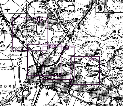
USE OF AERIAL PHOTOGRAPHS The aerial photograph heritage is a working tool that is common to many sectors, e.g. for everything that regards knowledge of the land, and in particular knowledge of the evolution of urban and environmental phenomena, studies relating to the cultural heritage (environmental, panoramas, archaeological, artistic, and historical), contentious and legal aspects, damage assessment etc. Whoever the user, the procedure to use aerial photographic documents is the same. Users search for what they're looking for among the mass of material available. This generally takes place using flight graphics (see Fig. 1) with which one can locate the area of interest, the filming data, and some technical characteristics. This initial search defines a set of photograms that potentially contain the information being looked for. These photograms are then taken from archives and examined. If they meet the needs and if a first examination is not enough for the user's needs, copies are made. One of the first critical points in this process is the search for photograms that are potentially interesting. Given the burden of retrieving photograms from the archives, the process of identifying the potentially interesting images must be as precise as possible (avoiding unsuitable ones and not neglecting interesting ones). Another critical point is the user's need to physically go to the place where the photograms are located. DESCRIPTORS OF AN AERIAL PHOTOGRAPH The information that identifies a photogram and associates it with the territory is a descriptor. This descriptor consists of a geometrical figure (typically quadrilateral) which indicates, on a reference map, the area covered by the photogram and a series of parameters that identify the characteristics of the flight and of the filming. The area covered by the photograms is traditionally drawn on a slide that can be laid over the reference map, and inside each quadrilateral there is the number of the photogram. The slide also contains other information common to several photograms (data taken, focus, etc) and information relating to the strips, i.e the set of photograms taken during one flight path without changing direction.
If there are many photograms for a particular area, for readability several slides are made each with a certain number of descriptors. The slides generally contain descriptors relating to photograms that have characteristics of homogeneity (same collection, taken on same date, same scale, etc). When operating without the aid of data processing techniques, the search for photograms takes place by manually overlaying the slides containing the descriptors on the reference map (generally 1:100000 scale), and by thus selecting a number of photograms that concern a certain area. However before identifying on a slide the relevant photograms, a preselection is made based on the data, the scale and on other parameters. This basically entails choosing from all the available slides the ones that potentially contain the information desired. This kind of search is based on a dual level cataloguing: the first contains general information on a set of photograms (data, average height, type of film, etc), the second contains the location of the individual photograms. ORGANIZATION OF THE INFORMATION The aerial photographic material available in an archive is very heterogeneous. A correct logical modelling should consider as its base entity the abstract concept of a snapshot, i.e. a photo taken at a particular time and place, of which several versions exist (one or more positive) with different characteristics. However, simplified model is enough which reports:
Notice the need to manage the date of filming with an interval logic. The uncertainty related to many acquisitions, especially historical ones, means that a period has to be defined by two extremes, within which filming took place. GEOREFERENCING AERIAL PHOTOGRAPH DESCRIPTORS The connection between filming and the land area in question is one of the main keys for searching for photograms in an archive and GIS technology is well suited to this aim. Georeferencing can be direct or indirect. In the first case the area filmed is identified as a polygon, generally a quadrilateral, as shown in Figure 1. The coordinates of the vertices of the quadrilateral can be digitized for data processing. The accuracy of this georeferencing technique depends on how accurate the coordinates of the vertices are. The second georeferencing technique uses a reference to other objects in the territory that are considered within the film sequence as the most interesting in terms of a certain application or a certain culture. The advantages and disadvantages of the two solutions are typical of the direct and indirect positioning of GIS applications. Direct georeferencing is generally more expensive than other techniques. However it is more stable as it does not depend on other entities on the land, which are generally subject to change. The knowledge via coordinates of the polygon that describes the area covered by a photogram allows, by using computer tools, three types of search:
The cartographic base used as a background and the other reference objects are GIS information layers which in this application take the name of the reference layer or reference background. These reference layers can be both raster (rasterized cartography, remote-sensed images) and vectorial (administrative, infrastructure, and constraint data, etc). For visual indirect search both raster and vectorial data are used; for indirect automatic search vectorial data are required. The three types of search described overcome the problems created by indirect georeferencing. In fact, modifying a reference layer doesn't modify at all the information relating to the photogram. Replacing one background with another more updated one has no consequences either for the archives or for the user. In addition, reference layers can be added over time so as to have several search keys for the specific aim. Searches based on the area covered by the photograms are integrated with searches based on the values of the attributes, both those relating to the image and those that describe the various supports. Thus via a GIS tool that manages both the descriptors of the photograms and the background, spatial queries can be made (e.g. which photograms are of the mouth of the Nile) besides the usual alphanumerical queries on the attributes (e.g. Which photograms have a particular authorization permit?). Or both types of query can be combined (e.g. Which photograms cover a particular district on a scale greater than 1:200000 and were taken between 1960 and 1966?). The latter type of query only takes one operation whereas as manually it would have taken two. The use of GIS tools for applications of this type is obvious, and the descriptors of the photograms are in every sense GIS type data. Nevertheless, note that the areas that describe the photograms are intersected and thus, GIS speaking, are not a planar graph. ARCHIE: A SYSTEM FOR CONSULTING ARCHIVES OF AERIAL PHOTOGRAPHS Archie is an ArcView application that allows the management of large-sized archives so as to be able to select photograms or strips of specific areas and with particular characteristics. Archie manages archives in which information is stored that describes both the strips and the individual photograms of one or more aerial film. Archie allows:
To simplify consultation Archie offers auxiliary functionalities that allow users to find easily and quickly the geographical area of interest. These functionalities allow users to:
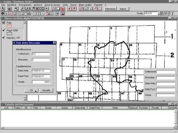
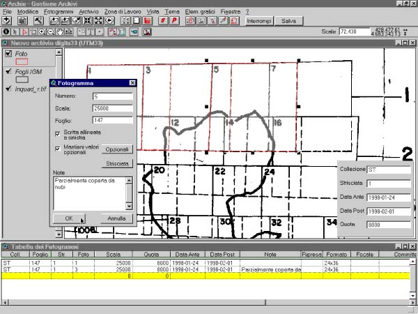
If the photograms (or some of them) have been rasterized, Archie allows users to display the selected ones for video consultation. However if the photograms have not been rasterized, print functions can be activated for reports containing the list of photograms currently selected, with the relative characteristics or maps scaled suitably for the zone in question and the photograms selected. The organization of the descriptors of the photograms in one or more information layers depends exclusively on the organizational criteria chosen by the body that manages the archive of aerial photographs. Archie can thus operate both on one archive and on different archives in which the manager has divided the descriptors according to his/her own criteria. An archive generally has aerial photographs from many strips and from several filming flights. This implies that, in addition to the overlay of photograms belonging to a certain strip, there are overlays between strips belonging to the same flight and to different flights. Overlaying a great number of photograms creates display problems and makes it difficult to select with a mouse the photograms that are of interest. To resolve this problem, Archie allows one to adopt a hierarchical approach by making a series of restrictions on the data selected, both spatial and alphanumerical. DIGITIZING THE DESCRIPTORS The availability of descriptors of aerial photographs with data processing support entails a data digitizing process, both for the alphanumerical part and for the graphic part. In most cases today for newly produced material suppliers companies are required to provide descriptors in numerical format. Archie allows the digitization of descriptors via the Gestarc module. Digitizing the geographical part consists in 'outlining' the edges of the photograms on a reference background. Typically this involves using a scanner-acquired image of the flight graphic, on which the edge of the photograms have already been outlined. The edges of the photograms can also be digitized by singling out on the photogram a series of points that identify objects that are sure to be found on a reference map or in a georeferenced raster image (Figure 2). Before beginning digitizing, GestArc asks the user to set the characteristics that are common for a series of photograms belonging to the same strip (collection, strip number, date period, height). When the edges of the photograms are digitized the characteristics of the strip are automatically reported in the descriptor of the photogram. When the digitizing of the area covered by a photogram has terminated, a Photogram window appears so that the technical characteristics of the current photogram can be inserted, such as the number of the photogram, scale, notes. If necessary, users can in any case access another window that allows them to insert or modify the value of the other attributes. The number of the photogram is proposed by the system (calculated as the number of the photogram previously digitized increased by one stage? which can be specified by the user), but can be modified. GestArc checks that number is unique within a strip. Also the relevant map number is inserted automatically (calculated as the map that contains the most substantial part of the photogram). The settings of the scale, orientation of the label (reporting the photogram number) the notes and any other attributes, are maintained for subsequent photograms, until they are expressly modified.
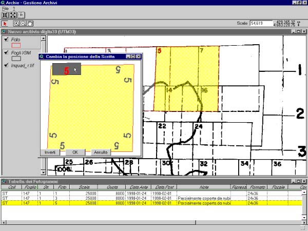
The position and orientation of the writing are determined when digitizing takes place, following the order with which the vertices of the photogram are digitized. If errors are found, both the position and orientation of the writing can be modified, without having to redigitize the edges of the photogram.
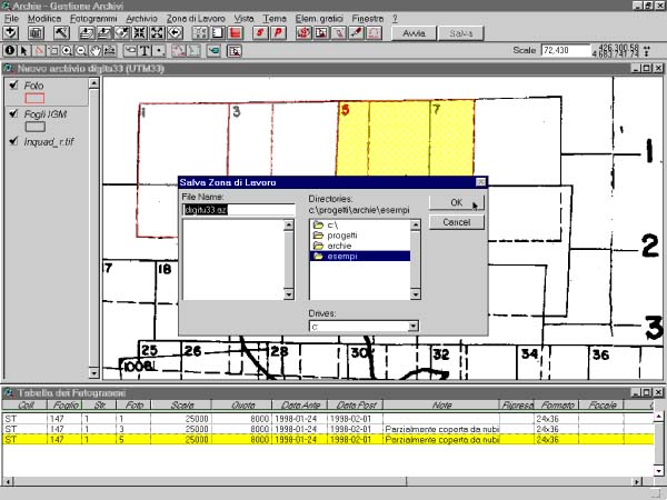
Both when consulting and acquiring, operators act in a logical window, or work area, defined as the geographical area within which some data are active (descriptors and reference background). The description of a work area can be stored via a symbolic name and when the work area is called the same situation is presented as when it was saved (e.g. with reference background, selection and zooms). It is thus possible to interrupt the work to begin it again later, or to save the information related to a geographical area and the reference data for re-use in other work sessions. (see Figure 5)
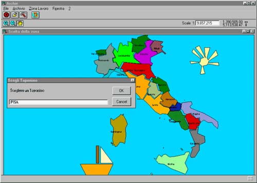
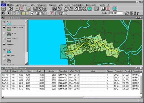
AN EXAMPLE OF CONSULTATION The area on which to make the consultation can be identified via successive zooms on a reference map or via a toponym.
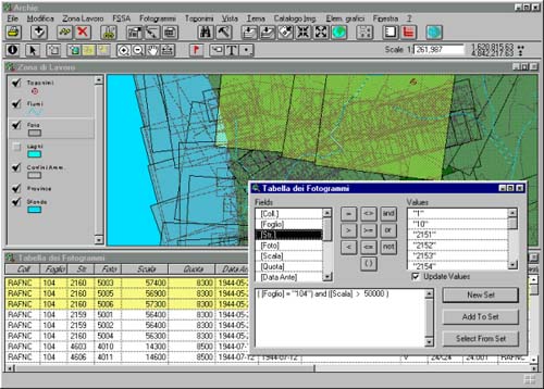
When the consultation zone has been established, the system zooms over the geographical area identified and automatically applies a filter for which only the photograms that belong to that area are selected. The area can also be chosen indirectly by defining as the coverage area all the photograms that satisfy a specified logical criteria (e.g. belonging to a period, or to a map). When a work area has been chosen, a window is opened that contains the portion of the territory identified in which the edges of the photogram are shown; and the table of photograms that contains the characteristics of the photograms relative to the work area. Queries can be made on the table by setting criteria on the characteristics of the photograms (e.g. Date > "1944") And ([Scale] > 50000))).
Queries are made only on the set of photograms that belong to the work area. The selected descriptors are highlighted simultaneously on the work area and on the table. The photograms selected via any criteria (both spatial and logical) are used to define a virtual information layer that is displayed on the work area (the starting layer can be "off" to display the work subset better). The new information layer is generally given a name that recalls the criteria that generated it (e.g. 1944, >50000 ").
The procedure can be repeated until a work subset is obtained that contains only the photograms that are needed for consultation. Besides the queries on the attributes of the photograms spatial queries can be made and the two types of query can be combined: from the descriptors that have a <15000 scale the descriptors that intersect the River Arno are extracted. The selected descriptors are used to build the work set "Arno, <15000". Beforehand other work subsets were created that still exist and can be displayed again and compared with the current subset.
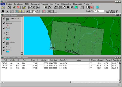
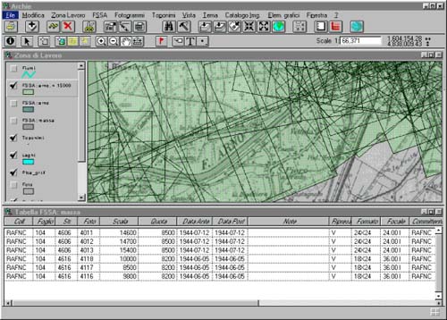
To check which area is really covered by the photograms a raster image can be displayed overlaying the work area. To be able to examine appropriately the overlap of the edges of the photograms with the raster images the mechanism of work subsets is essential.
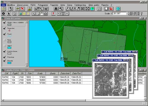
Once the final work subset has been identified, if the archive is in digital format then the photograms can be consulted. On the other hand, if the archive is on a traditional support then one can print the map of the work area or a list of descriptors.
Before printing it is useful to display the photogram number. ACKNOWLEDGEMENTS Thanks to Maria Filomena Boemi, Director of the "Laboratorio per la Fotointerpretazione e l’Aerofotogrammetria" for her contribution. Her precious suggestions derived from studies and long term experience in organizing and computerizing the Laboratory. BIBLIOGRAPHY
|
     |
    |
 |
| [Introduction] [Conference programme] [Presentation by authors] [Presentation by category] [Poster session] [List of european Esri distributors] [List of exhibitor] [Esri products news] [Credits] |