Pierluigi Soddu
Servizio Sismico Nazionale, D.S.T.N., Via
Curtatone,3 00185 Roma, ++39 06 44442345 fax ++39 06
4466579, e_mail soddu@ssn.dstn.pcm.itMaria Giovanna Martini
Servizio Sismico Nazionale, D.S.T.N., Via
Curtatone,3 00185 Roma, ++39 06 44442546 fax ++39 06
4466579, e_mail martini@ssn.dstn.pcm.it
Rita Nicolini
Provincia di Modena, Assessorato Difesa del
Suolo, Ufficio Protezione Civile, Via Barozzi, 34 41160
Modena, ++ 39 059 209429
Abstract
"Sige on
line" represent the evolution of the current
Info-System dedicated to the management of an emergency
in case of a seismic event (SIGE), currently on service
at the National Seismic Survey.
"Sige on
Line" goes over the "Local" operating
condition, task previously done by "SIGE",
becoming a new concept of "Distributed"
activity and different field of operativity, trough the
integration of different technologies: GIS, WEB,
line-links. Etc.
After a
simplified description of the SIGE, in the article, is
illustrated the new project: SIGE ON LINE (SOL) and a
experimental application (with the contribution and
participation of the National Seismic Survey, the
Department of "Protezione Civile" and the
province of Modena).
INTRODUCTION
The Seismic Survey, in charge as
member of the Civil Defence body (law 225/92), has to
provide the specific activities for the aftermath of the
seismic event and its following post-event management.
- SIGE
SIGE is an integrated tool used for
supporting Civil Defence operations in case of seismic
events in Italy (areas), with the aim to do prevention,
minimise impacts and facilitate emergency intervention.
This task is fulfilled through the production of
real-time tabular reports, technical maps, and relevant
scenarios.
The System use the data (location,
magnitude, time) of ING (Istituto Nazionale di Geofisica)
(monitoring) seismic network, in connection with the
integrated Seismic Risk Information System. The data flow
of SIGE system is in fig.1.
Just after the "event"
the Seismic Survey gives an informative report called
SIGE: such report gives an homogeneous information
content, allowing to value the global square area of the
seismic phenomenon as to its entity, land extension and
social urbanised contest involved.
After 45 minutes from the
signalling of the event, the report (paper report) is
transmitted from Seismic Survey employees to Civil
Defence Department. In this way it is possible to
overcome knowledge blackout occurring immediately after
"post-event".
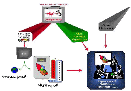
Fig.1 Information flow of SIGE system
Report contents (see fig. 2) cover
the following areas: demography, services, networks, and
historical seismology, damage scenarios (property and
people).
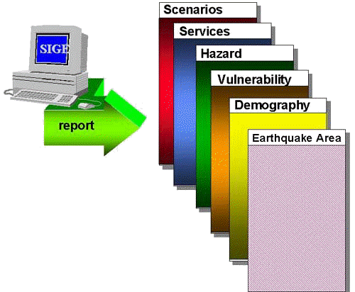
Fig.2 SIGE Report
The whole report (index in tab.1)
is care of the Internet site of the Dipartimento per i
Servizi Tecnici Nazionali.
| Figure |
Description |
| 1 |
Earthquake
area |
| 2 |
Municipalities
around 50 Km of the epicenter |
| 3 |
Resident
population |
| 4 |
Official
seismic classification (municipality) |
| 5 |
Population
density (inhabitant/Kmsq.) |
| 6 |
Percentage
of habitations for municipality |
| 7 |
Percentage
of habitations in class A (MSK scale) |
| 8 |
Percentage
of habitations build before the (municipality)
seismic classification |
| 9 |
Number
of hospitals (public and private) |
| 10 |
Number
of school rooms |
| 11 12 13 |
Number
of potential risk industries (class A B C) |
| 14 |
Vulnerability
for landslide |
| 15 |
Dams |
| 16 17 |
Roads,
Railways, Airports (around 150 and 25 Km of the
epicentral area) |
| 18 |
Earthquake
database: NT4 (Intensity MCS 5) |
| 19 20 21 22 23 24 |
Macroseismic
field of historical earthquakes: 1349,1695, 1799,
1898, 1904, 1943 |
| 25 |
Expected
Intensity (MCS scale) |
| 26 27 28 29 |
Expected
value of PGA (g), PGV (cm/sec), PSA (T =0.2 sec,
Hz.=5.00), PSA (T=0.5 sec, Hz=2.00 Hz) |
| 30 |
Seismic
and acceleration networks |
| 31 |
Expected
total collapsed habitations |
| 32 |
Expected
unsafe habitations |
| 33 |
Expected
percentage of collapsed habitations |
| 34 |
Expected
percentage of unsafe habitations |
| 35 |
Expected
value of people involved |
| 36 |
Expected
value of homelessness |
| Table |
Description |
| 1 |
Territory
and Population |
| 2 |
Vulnerability
MSK |
| 3 |
Risk
factories |
| 4 |
Schools
and Hotels |
| 5 6 |
Hospitals
( Public and private, beds) |
| 7 |
Dams |
| 8 |
Earthquake
database: NT4 |
| 9 |
Seismic
and acceleration networks |
| 10 10a 11 |
Building
forecast loss (value and percentage) |
| 12 |
Earthquake
casualty estimates |
| 13 |
Forecast
monetary losses |
Tab.1.
Index of SIGE report
But SIGE is affected of these
restrictions:
- Start Time. Actually SIGE
starts by manual input and produces the SIGE
report (cartaceous) after 30-45 minutes;
- SIGE runs locally and the
report is not interactive (obviously);
- SIGE is not set up to receive
(automatically) information from the epicentral
area;
- Normally need 24 hours to
insert SIGE report on the WEB site of Department.
The SIGE system use :
- Hardware: HP/9000/755: two
Unix workstations with duplicated database;
- Software: Arc Info and Oracle.
The SIGE data bank (demography,
urban areas, services (hospital, schools), historical
seismology, roads, dams, factories, etc) have these focal
points:
- It is referred to the whole
Italian territory;
- It is relative to the
administrative municipality areas;
- Surveying and processing is
homogeneous;
- It has an official character.
- SIGE ON LINE
"Sige on Line" (in case
of a seismic event) will link the different operative
units displaced on the national territory (law 225/920),
connecting the central operation unit of the national
seismic Survey with the head office of "Dipartimento
of Protezione Civile" and also with the local
administration's operation units, regions, provinces,
prefectures.
The Idea of " SIGE ON LINE
(SOL)" was born at the time of the seismic sequences
that hit (September 1997) the Umbria – Marche
regions. SOL gives a possible solution about the
SIGE’s restrictions described before.
SOL’s goal is to manage the
seismic emergency from its very beginning (with possible
activation from a remote system) then it provide to give
a representation of the territory and probable scenarios
of the damaged areas, and subsequently to the further
complex stage of post-emergency management:
- BEGGINING. SOL, when an
earthquake hits the Italian territory and the
intensity is over the minimun threshold, produces
two types of reports: an interactive report (in
digital format: Arcview project), and a
classical cartaceous report.
- DURING the emergency. In the
first fase SOL produces all the files that the
technical teams will collect in the field, using
the "Mobile Computing" structures, the
data about damages. Normally this survey may last
3-5 days after the main shock. In a second phase,
once the communications are activated with the
C.O.M. (focal and operative points of Civil
Defence in the earthquake area), to monitorize
the emergency management in the area, SOL
receives and organises the data coming from the
involved area and the SSN team open the EMERWEB
(data broadcasting WEB site) for the selected
client (normally Civil Defence client).
The functionality required
by SOL are illustrated in the figure 3 and then can see
summarised in the following points:
- Mobile Computing. Hardware and
software for the SSN technical teams. Data
collection on the field.
- Automatic or manual SOL
activation from remote qualified client.
- Providing of dynamic
scenarios, collecting the information from the
incident areas in real time.
- A reserved line with the Civil
Defence Department.
- Selective dispatching of the
remote Civil Defence stations.
- Connection with remote
operative units activated only in case of
emergency (CCS – COM); Automatic release of
info report.
- Delivery of the reports to the
selected offices and possible printing option
from the remote units.
- Creation of emergency and
dedicated WEB site. In this site will convey:
SIGE report, informations regarding the damages
and the emergency management. An e-mail system
and a back-up system of the data stored in remote
stations will be activated. It is foreseen the
development of interactive data bases for
consultations.
The SOL hardware structures will
consist of high availability system (3 Unix
workstation connected in cluster system with databases
stored in a "raid" system). The software used
will be Arc-Info, Oracle, Arcview.
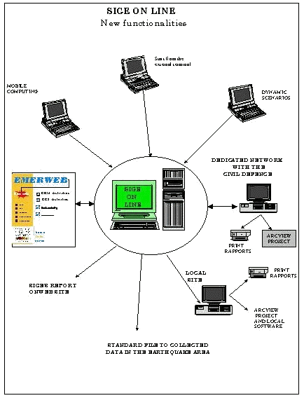
Fig.3 SOL – New functionalities
The core of SOL is a Geographical
Information System. The strategic role of a dedicated
information system is represented by the final product
preparation. Such system is capable of operating during
each of the three phases of the Civil Defence operations:
Forecasting, Prevention and Emergency Management. (See
fig. 4)
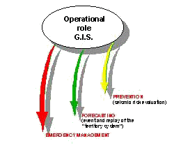
Fig. 4 G.I.S. operational role
More in detail the seismic risk in
the study area can be evaluated during the Prevention
phase. Seismic risk is a combination of:
- hazard: which represents the
physical characteristics of the territory, as far
as seismic events are concerned;
- vulnerability: which is the
tendency of a valuable object or individual to be
effected by from damages and loss of serviceability,
caused by a natural disasters, such as
earthquakes;
- exposition: which identifies
the quantity and the quality of valuable objects
and number of individuals exposed to seismic
hazard.
During the Forecasting Phase the
information system provide a scenario identification,
following a seismic event of know magnitude. GIS
simulates the response of the territory to the event.
During the Emergency Management
phase, the capacity of the Civil Defence Department to
respond to the event efficiently is fundamental.
Its operational structure must be
provided with:
- the complete information sets
mentioned above.
- the distribution in the
territory of the emergency facilities, hospitals
and hotels.
- the faster routes accessing
the area hit by the earthquake;
- check of the emergency
management procedures.
Since the SOL experimental phase a
collaboration with the Modema province (local Civil
Defence). has been established. Together we study and
developed an application dedicated to the seismic risk
management.
In case an earthquake would hit the
province of Modena or its surrounding area, SOL operates
according to the following scheme:
At the SSN H.Q.
- Produce report (with a small
scale resolution: minimum level is the
municipality, since operating on a national
level).
- Send the digital report to the
Civil Defence Department (normally after 5
minutes after the start of SOL).
- Send the digital report to the
Modena pc station.
In the remote units:
- Civil Defence Department :
notification of the report arrival and its
consultation through the predisposed application.
Possible print of the SIGE report or specific
themes.
- Civil Defence Office (Modena):
notification of report received. The application,
operatin localy, subtract a subset of the
information sent (energy distribution and
scenarios of epicentral area) and do aimed
selections at a big scale (desegregation level is
census zone) on the population (divided by age
classes), building typology, civil defence
resources displacement.
Example of SOL products are
illustrated:
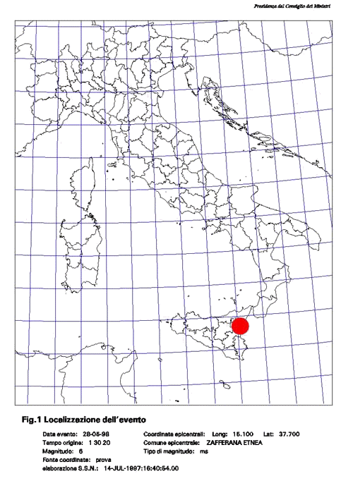
fig.5 Localization of epicentre (first page of SIGE
report). The area is the Sicilia island (SOL work on the
whole italian area).
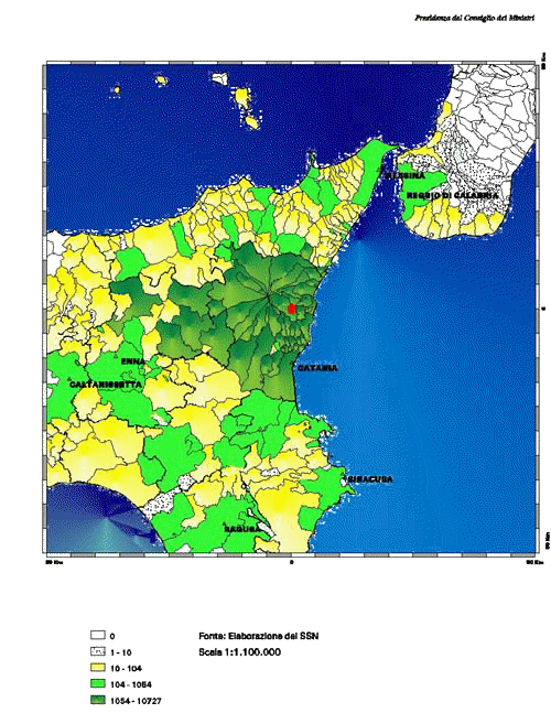
Fig.6 Expected value of homelessness (same area of
fig.5).
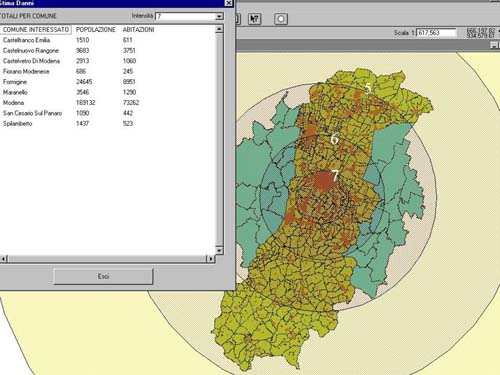
Fig.7 Sample of local application (Modena epicental
area). Table: municipality, people, houses (selection by
intensity = 7 degree MCS). Map: Municipalities,
Localities (subset of municipality), administration
boundary. The graphiccircles, extracted automatically
from SSN digital report, are the selection area.
Conclusion
SOL in progress project and the
dead line is the next year. Same functions are
experimentally and probably we change it or we insert the
new one, but this is the story.
|


