|
THE ST. MARCUS’ BASIN IN VENICE (ITALY): THE BASILICA, THE PLACE AND THE SEA WATER. THE PROPOSAL OF GIS MODEL BUILT WITH ARCINFO TO RELATE THE ARCHIVES OF INFORMATIONS IN ORDER TO MANAGE THE CONSERVATION AND THE MAINTENANCE OF THE BASIN |
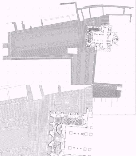
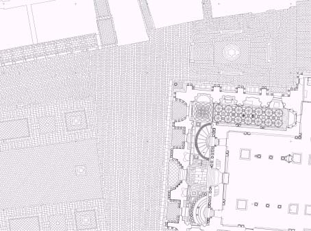
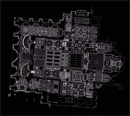
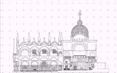
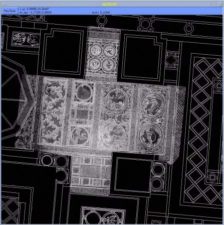
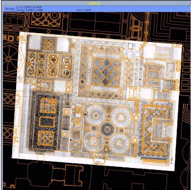
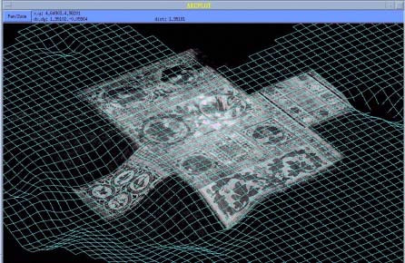
| Carlo Monti Full professor , DIIAR Director, DIIAR Dipartimento di Ingegneria Idraulica Ambientale e del Rilevamento - Sezione Rilevamento, Politecnico di Milano, P.za Leonardo da Vinci 32, 20133 Milano, tel (+39- 2) 23996240 fax (+39-2) 23996550, direz@idra5.iar.polimi.it Raffaella Brumana Cristiana Achille Caterina Balletti Luigi Fregonese Francesco Guerra Carlo Savi Abstract Within the cooperation begun many years ago with the Procuratoria of San Marco and with its Proto, the Arch. Ettore Vio, it has been started up a management project of the richness life of the Basilica (the geometrical, material, and static background, the history of the events, of the restorations and of the different cultures testified in the material traces. The research here summarized deals with an approach to relational models developed by heterogeneous data survey and managed on Geographic Information Systems built with ArcInfo as contribution to the description of a complex and dynamic Basin like it is the one around the Basilica of Saint Marcus in Venice. It has been built up an hypothesis of a GIS to support the behaviour of the tide of the Basin and to support the ordinary maintenance of the Basilica and of its mosaic surfaces. It has been supposed and described a data model to manage the acquisition and processing of all data surveys and controls, realized from 1980 to now, the horizontal and altimetric sections, the photogrammetric restitutions, both raster and vector: in the model data are involved the contour level representations, the digital orthophoto projections georeferenced to the DTM, the images projection on the DTM, the TIN - Triangular Irregular Network by random data and the profile analysis. The geometrical survey become the natural reference to non geometrical analysis level, that’s to say to the material and to the technological analysis, to the static check and to the historical archives. Key words: GIS Model, Historical and Ichonographical Archives, Ordinary Maintenance Management, Data Surveys INTRODUCTION If the cognitive process is endless, since the information and the relations set up are endless, it doesn’t seem acceptable to limit the registration of the same, because it would be signify the loose of culture and then of knowledge chances. To order data in open and updated information systems answers to the need to avoid more possible the loosing of information, expanding the relationability and the identification of these knowledge and the use of this knowledge. The effort of the research in the field of the integration of heterogeneous data built up in the different diagnostic disciplines, is now giving good promising results: today is a reality the access to remote and local data banks, whose models provide by graphic-numerical information (raster-vector) either bidimensional than three-dimensional, on which are georeferenced classes of encoded attributes. The information can be structured in simplex model (overlay, layer) by superimposition, but can also be structured in more complex model. Particularly GIS technology has the aim to obtain forms of knowledge through the analysis of data to support decisions about planning, prevention, maintenance, consolidation and adjustment of the architectural manufacts. The consultation of informative areas becoming from different fonts depends on the management in relational data base, where is defined the position and the topology, that’s to say the mutual spatial relations between elements and entities of the architectural object. The research in this field is oriented to identify typologies of data association so to identify no expected relations, soft analysis obtained through logical connection, through algorithms to translate mathematical functions. GIS, if not distorted and strumentalized, must absolves not only to a documentative work but to a managerial work, and can go out from the shadow of the simply qualitative verification, born by a cataloguing system now obsolete, to become an important instrument of planning and management of conservation and restoration. What is difficult is the modelling of qualitative elements, numerical and quantified data, apparently not comparable: the relationability of both depends on the planning target. The risk is to dissipate the cognitive status, available but substantially unused , or betrayed by the alibi of analytical process from which often it isn’t known or enough clear how to derive project decisions enough suitable: the verify of consistency is not given beforehand , but can be carried on with critical method discussing constantly relations between data, theory, decisions and hypotheses. The project of GIS needs either scientific approach strictly connected with auto correction and adjustment than identification of certifying methodologies. Check up of results is possible if quantitative and qualitative parameters are modelled on reality so to compare survey, data acquisition, aim, the certification of project and conservative restoration. The possibility to identify accurate and exact relations between data, aim and results, depends on the degree of development of the research in many different fields: from the Ambient Evaluation Impact on architectural manufacts of the projects, to the evaluation of the compatibility of functional destination, old and new, to the evaluation of static support and of technological structures. Figure1 Figure 2 All these function can be successfully developed in GIS organized on the details of each monument, of each situation. But it can also represent a valid instrument to the action of prevention widespread distributed and monitored: for this matter is necessary to find differentiated parameters on which is based the simulation of structural behaviour and deformations of objects to stress conditions, to systems of variables supposed, or to the boundary values. Consequently is important to obtain fine knowledge of the state of the art and then the selection of data to acquire for this aim, the capacity of interpretative degree of complex reality of the manufacts in a dynamic key, in non static point of view. Building up one system of referenced description become a decisive element to define methods to create and manage also the maps of the risks, the valuation of deterioration and of instability and of stratigraphic analysis. The aim is the development of thematic maps and cartography, where also non destructive analysis (thermograph, photo-interpretation...) metrically comparable using digital images and methodologies of processing different level of images. The multimedia systems of communication, the network connection between the different data bank, the level of acquisition and the level of management, planning, projecting and administration allows the GIS, once structured, to be available from remote places and from technicians and operators which use data survey to plan and project. This answers to the necessity to divide the level of the logical structuration of GIS, that’s to say the one of the project of the GIS, from the one of data acquisition and from the one of management. All these levels need diversified skills to which the education must answers; all the levels ask for a specific Hardware and Software support, in function of the need and of the financial resources. If the level of logical project of a complex GIS find its natural place in advanced SW, such as ArcInfo, the level of data acquisition can be faced with ArcView, the typology of Data Bank Management can be organized with Relational Data Bank Management System, and finally the low level of GIS access (perhaps the tourist access to the information) can be approach with GIS tools processed on Line (i.e. Map Object Internet Map Server). Particularly the output of data entry can be directed on Data Bank of high dimension through the client server system which allows the access to this data bank detached to the Software of managing GIS. The Network connection of PC used by local administration and the use of standard transfer protocols can build the base of information which will be integrated in the higher planning levels, which are approachable from the different levels. If the acquisition of data is decentred, the management is entrusted to the different planning level interested which warrant flexibility of using data. The GIS technology has been developed in the territorial, urban and environmental fields: here we want to introduce the apply of GIS technology to support decision system in the field of Architectural Reality, to manage the Ordinary maintenance in a Nation with one of the higher widespread diffusion of Cultural Heritage and to avoid the special interventions which are more destructive than the conservation aim. It signify to use the GIS as a valid instrument to manage not only the project of conservation, but the resources management, the economic and financial planning related to the map of risk, to the level of hydrogeologic state of art, and generally to socio-economic and environmental policies. 1. THE GIS BASIN 1.1 The Surveys It has been hypotized and realized different survey levels strictly related one to the other to improve the knowledge of the geometrical characteristics of all the Basin. The survey of the Basin needed an extraordinary effort of human, economic and technical resource. The surveys has been realized to identify all the floor stone by stone (called "masegno") of all the Place and to generate a fine 3D-surface for the altimetric control through a grid. The work was organized in different phases :
Figure 3
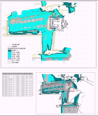
Figure 4 1.2 The GIS Basin Once realized the geometric support, is was possible to introduce and relate all the data bank and organize the GIS model. If the high tide is a problem for the Basin, the aim is to defence and put in safety all the Basin, the Place and the architectural building faced on the Place: it’s explained an hypothesis of GIS to check daily the level of the water and to build an hydrological model of the annual behaviour of the water levels in order to know the areas interested to the natural phenomena of high tide in function of the level risen up by the water, to plan the accessibility of every location (shop, houses, tourist destinations…) and to set course of people. It has been surveyed, catalogued and georeferenced all the shapes of the stones of the place (more than 100000) to allow to bring out them and to locate in the same position the stone each self preserving the irregularity of the place in case of restoration; at the same time it has been surveyed all the manholes from which the water rise up during the high tide. The model can be used to determine in different conditions (periods, seasons, moon) which areas would be affected by the potential flood. The data of the tide has been set up by the "Centro Previsioni e Segnalazione delle Maree del Comune di Venezia, Assessorato Trasporti e Servizi Pubblici (a centre of forecast and signalling of the tide made by the Venetian Administration; for every day of the year it has been given the hour of the survey, the tide level on the sea respect to the "Punta della Salute" in front of the Basin. Thank to a client server organization of the GIS it would be possible to directly connect by SQL to these data bank organized in different servers and manage the data on the GIS (Fig.4) through network connections. If it’s obviously the useful of such a Gis to manage the problem of the conveyance and to guarantee a public service of transport to the local and tourist traffic in the period characterized by the high tide, it would be so much fundamental as that one, is less obviously the role of an organization of a GIS (in this case ArcInfo) as a client software which "talk" with all the data bank remote placed in function of the different sources of data acquisition. It can be possible to suppose different GIS logical structures and interpretative model of the reality, perhaps to manage and optimize the traffic in function of the Tide, to manage tide data related to the elevation model of the place, to analyse trend, to make a prevention politic in case of risk, etc. In simple word, we can say many data servers points and many GIS software clients (from the Office of the different Local Administration to the Region a National One, to the office of the Procuratoria of San Marco, of the Magistrato delle Acque, to the Tourist Agencies, etc. Through Relational Data Bank Management Systems (i.e. Oracle) the Data Bank can be accessed from remote places (the different centres which use GIS technology) with lot of access managed contemporaneously. 2. A GIS MODEL PROTOTYPE SUPPOSED TO MANAGE AND SUPPORT THE ORDINARY MAINTENANCE IN THE BASILICA AND ITS MOSAIC SURFACES. It’s here presented the GIS model supposed to manage the ordinary maintenance of the mosaic surfaces: the Basilica has 8600 squares meters of mosaics wall and 2250 squares meters of mosaic floor!. This exceptional reality need to relate and use all the information integrated one to the other and referred to the geometrical surveys.: the historical Archives (the Informative System realized some years ago has collect all the documents and iconographic tables but it is not related to the geographic entities and to the others archives), the material - technological and chemical analysis. The high costs of the restoration of one square meter of mosaic can amount to 1000¸ 30000 US$, in function of the type of restoration:
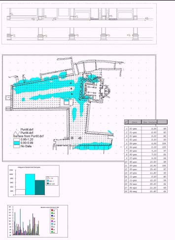
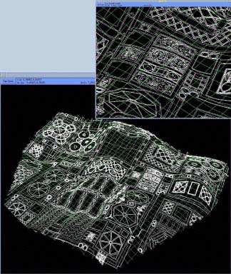
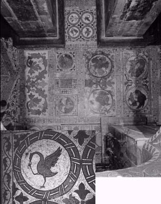
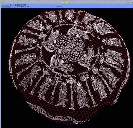
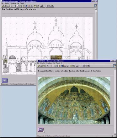
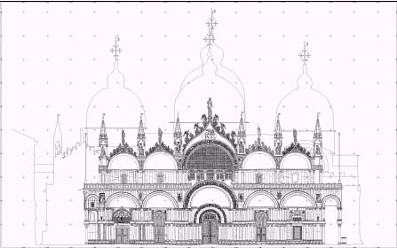
On average to restore 3¸5 square meters of mosaic surface are employed 3 persons for 5 months: in the Basilica work about 25 skilled workers all the years. The high costs oblige to optimise the effort to obtain in real time a fine knowledge ot the state of art, and consequently the selection of data to acquire for this aim, the level of degree of complex reality of these manufacts in a dynamic key, in non static point of view: in the phase of restoration the 3D support of the mosaical surfaces (derived from the controls) are related to all the iconographical documents which are referred to the part of the intervention: it’s necessary to identify the documents above the thousand existing (Figg.7-11). The cost for the creation of a GIS is high for the human capital employed, for the time and for the Hardware and Software investments, but is justify in the saving obtained from the real time knowledge of the single elements of the monument. Figure 5 It’s important to find modalities to make available the data to support restoration during the works and the project of the works: all the surveys (Figg.5,6), the surveys that need to be updated in the time (Fig.7), have to be quickly and easily available, on which base to cut the stone and marbles of the incomplete mosaic tesseras (fig.11), to select the materials and chromatic tonalities to allow to recognize the new intervention guaranteeing in the same time a new state of balance, and last to reference historical iconographic documents (Fig.10) and fonts of archives. Figure 6 Therefore building up one system of georeferentiated description become a decisive element to define methods to create and manage also the maps of the risks, the valuation of deterioration and the evaluation of instability and the stratigraphic analysis. The aim is to obtain thematic maps and cartography, where also non destructive analysis, like thermography, photo-interpretation - once metrically comparable - will be used on digital format developing methodologies of processing different level of images. To describe a dynamic and complex reality, like it is the Basilica of St. Marcus, it’s not only requested to integrate surveying methodologies, but to build up and to translate from these one also differentiated interpretation models: the research deals with the interactive management of the data surveys and of the own representations. The example here explained is the statement of GIS to support the ordinary maintenance of the Basilica of St. Marcus, and the conservation of the data, the one settled during the centuries and the one produced by the history of every day. If the phase of acquisition and creation of integrated archives of the different numerical surveys (raster-vector) is already begun from some years and continuously adjourned, in the same time the phase of acquisition on informatic support of the ichonographical and historical documentation, which has been conserved in the centuries in the Basilica, has been structured in an organic Informative System. In the patient and constantly work of prevention and maintenance which characterises the direction of the works is located the effort to begin an integrated archive of the two corpus, which must be able to manage cognitive elements time by time acquired, from macroscopic to microscopic reality. Figure 7 Figure 8 GIS become the qualifying element to answer to the need of information coming from all the disciplines involved in the work of slowing down the deterioration and of material, technological and structural degenerative processes. Figure 9 The organic experimentation was built up and an open unit of cataloguing has carried on by the Procuratoria of St.Marcus. Graphic-numerical archive involves all different kinds of surveys: for example the one of the classical photogrammetric restitutions of all the internal and external fronts, of the domes (Fig.11) and of the punctual altimetric sections, both vertical and horizontal (Figg.4,5): from the superimposition of these one is possible to obtain another model: the model of the mutual positions, thickness, supporting modalities and rotations (entity and direction) between the stone elevation structures. On these surveys ISMES (ISTITUTO SPERIMENTALE MODELLI E STRUTTURE) has carried out the structural analysis building the 3D-solid model with its own sections, the model of the coverage deformation, the frame and the static model represented with chromatic scale . Figure 10 The management in the time of each one model is bound fast to the organisation of an Informative System, here structured in ArcInfo. The challenge is to make possible queries and answers not to homogeneous classes of data, but to heterogeneous classes through logical correlation traduced by algorithmic and topological functions, which have to spring out from the different disciplines involved by the common conservation aim: otherwise the risk is to lose the wealth of data basically unusable. One example is the study of a dynamic structure like it is the floor of the Basilica: here is represented the chromatic scale model of the fluctuation between two altimetric check made every six months on a sample of two thousand points surveyed with levelling (Fig.7). Another output is the Digital Elevation Model automatically updated. Figure 11 Both the DTM (of the dome of the "Ascensione" and of the floor) and the photogrammetric ichonographic models (Figg.7,12) are related each other by projection due to obtain the 3D-model of the deformations. The geometrical support represents the natural referring to various analysis, the one on the material wears, on microclimate and on the chemical and physical effects verified till to the level of the mosaic tessera. The digital images (Fig.9) at the different graphic scales are georeferenced not only in the plan but on the four-dimensional space (Fig.11) updated in the time: through the 3D-projection on the DTM they lose bidimensional support to acquire three dimensional information of the material support geometrically described. Figure 12 The different Archives built up can be connected on network in a client/server architecture which emprove the philosophy to keep separate the GIS level of managing from the level of data acquisition and organization: GIS held up logical relation, simple and complex, through SQL connections to Relational Data Base Management System: this would be the core of a structure which allows to build also a "GIS on Line" on Web Pages (Fig.13) to Distribute Geographic Information to the citizens (i.e. using Map Object Internet Map Server, query and answer tools are free on Line and does’t need of a client GIS ). Figure 13 Figure 14 REFERENCES
|
|
|
|
[Introduction] [Conference
programme] [Presentation by authors] [Presentation by
category] |