|
| A
CARTOGRAPHY FOR THE REPRESENTATION OF CULTURAL HERITAGES: THE EXAMPLE OF TUNISIA |
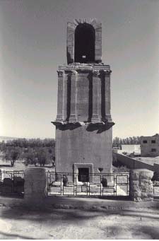
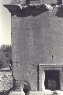
| Francesco Lavecchia Memar Sit Srl, Via Emilia San Pietro 22, 42100 Reggio Emilia Tel. 0522.432312 fax 432684 crcre@interbusiness.it Historic and archaeological sites This paper stems from the project "Gestion du patrimoine culturel de la Tunisie" for the setting up of a first nucleus of computerised data on the historical and archaeological heritage starting with the reconnaissance of protected monuments in the whole country. The standard graphic catalogues used are those established by the Council of Europe. The work started in September 1997: a year later the data is in the process of being organised for filing and the production of a computer data bank supported by a geographic information system. 300 sites have been visited and catalogued for a total of about 1,000 monuments with about 10,000 photos taken and 2,500 images of archival origin (historical photos, maps, cartography, aerial photos, basic texts etc.) for a total of 100 CD ROMs. A paper library composed of three hundred dossiers, one for each site, will be consigned to the Tunisian Cultural Ministry, and an easy-to-use electronic data bank (schedules, photos and maps) for the management of the historic-archaeological heritage inventory.
Products used and form of data The activity of loading data, both graphical and alphanumeric types, is carried out with the following I.T. tools:
Creation of the tables The alphanumeric tables are the fruit of a data entry activity directly linked to the descriptive schedules made during the survey of the cultural assets in the territory. The file produced is structured so as to guarantee any type of logical relationship in the project, and in particular, permits linkage between the various data bases with the relevant drawn subjects. Creation of the cartography The survey and the correct placing of the items which are cultural assets require the subdivision of the cartographic elements into two categories which are:
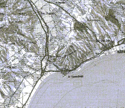
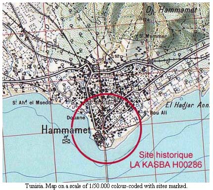
Cartography of the cultural heritages The administrative cartography is represented by both area and point elements where:
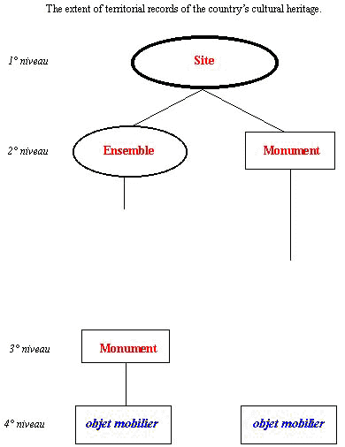
It is a representation of the monument based on its position in the site.
A. Databases produced and relative relationships The "site",
"ensemble" and "monument" cards are
primary schedules and identify univocally the objects
surveyed and recorded in cartographic form. Creation of the files The territorial information system is created by utilizing all the files: graphs and tables, generated during the data loading activity. The possibility of utilising a cartography which is perfectly geo-referenced and in absolute co-ordinates makes it possible to obtain a work base transposed in 1:1 scale, after allowing for errors arising from the precision of the acquisition maps. This situation allows us to operate in an absolutely free manner knowing that for any type of operation carried out on this cartographic system, distances and measurements are utilised which approach absolute and real values.
B. Application product Consultation of the data The most evaluative aspect of an information system is given by the possibility that a not particularly expert operator has of carrying out consultation operations on the data making up the various files. This occurs in a two-directional way, and has as its points of departure either the databases or the map-drawings, without distinction. The result of the interrogation, in both cases displays both the database records and the relevant graphic objects, guaranteeing the inheritability of the information between the different themes for spatial type inquiries. Graphic consultation For an information system to be defined as being correct and efficient it must be able to carry out both easy and complex consultation operations; with this objective we have utilised a cartographic system which must, necessarily, be a vectorial type, and structured according to a logical criterion. In fact all the objects which must make up the information system have been identified; they have been grouped according to themes, each of which represents a single and logical category of elements. The various themes, which make up the graphic data bank, have a hierarchical type logical sequence where an object contains others of an inferior category. This type of structure makes it possible to manage integrated relationships between the various cartographic themes activating the recognition of the various geometric congruences guaranteeing the inheritability of the information between the different themes, for spatial type inquiries. Graphic consultation is done by selecting one or more graphic elements on the video. In this way it is possible to carry out consultation of all the alphanumeric schedules which refer to the selected graphic objects. The graphic selections occur in the following ways:
Alphanumeric consultation Through the use of inquiries (query), alphanumeric consultation makes it possible to carry out filter operations on a single database, with the aim of individualising the elements corresponding to the characteristics which were the subject of the interrogation. An application may activate this filter process in the following ways:
Guided routes An application utilises a graphic and alphanumeric data bank with files generated with standardised characteristics. In the programming phase this permits the activation of pre-defined search programmes where the interrogations are the fruit of obliged choices both in terms of graphical elements and descriptive characteristics on which the filter operations are carried out according to the searches effected. These functions permit the execution of research operations, also by not particularly expert users, in a rapid and safe manner. Partially free interrogations The application continues to have a series of interrogation routes which are conditioned to guided types of research but, at the same time, is able to carry out searches of a free type activating the SQL language in an intelligent manner. This method allows us to make connections between tables which don't respond to any standard requisite, with those in the system which instead respond to the normalisation requisites of the system. Management of associated documents For each element surveyed during the scheduling activity, photographs are taken which give a correct and real vision of the registered objects. These photographs are taken from various points of view and aim at describing the elements showing up the most important characteristics and particularities. An alphanumeric schedule is compiled for each photo, arranged in fields, with the main characteristics indicated; the matching of the photo with the relative schedules is carried out by the operator in an interactive way with reference to the information shown by the surveyor and the photographer.
C. Application characteristics Maintaining the above-mentioned formats and data structures unaltered, interfacing ArcView with access becomes essential, as an initial operation; this makes the alphanumeric data bank immediately available to the Territorial Information System (T.I.S.), keeping the relationships which guarantee the crossed-over visibility of the data unaltered. The access database is in fact composed of a series of alphanumeric tables sub-divided into three parts (Site, Ensemble and Monument). These tables are structured in order to guarantee a series of logical relationships with the aim of ensuring the inheritability of common information. The cartography is composed of:
Every cartographic object is associated with an identification key which permits its individualisation and the relative linking with the table structure to which it refers.
The relationship between the table and the relative graphic objects is made through linking operations which from time to time have to guarantee the visualisation of the various schedule/graphic representations. In addition, it is necessary to activate minimum and maximum visualisation factors for each of the cartographic themes which form part of the T.I.S. in order to guarantee permanent correct visibility. The application product must permit the following operations:
Singling out one or more cartographic objects forming part of the same theme makes it possible, through the utilization of a series of personalised buttons, to activate the following consultations:
|
     |
    |
 |
| [Introduction] [Conference programme] [Presentation by authors] [Presentation
by category] [Poster session] [List of european Esri distributors] [List of exhibitor] [Esri products news] [Credits] |