|
| INFORMATION TECHNOLOGY MANAGEMENT PLAN, DATABASE DESIGN AND GIS APPLICATION DEVELOPMENT |
| E. Karagüllü Ministry of Agriculture and Rural Affairs, General Directorate of Agricultural Research, Bagdat Cad. Istanbul Yolu No:238, 06171, P.O. box: 78, Ankara/Turkey, Tel +90 312 3157623, Fax +90 312 3152698 D. Sherrill F. Ernst M. Akdogan M. PeskIrcIoglu S. Özbayrak E. Özek Abstract Turkish government organizations are participating in the World Bank sponsored In-situ Conservation of Genetic Diversity Project. As part of this project a GIS and Remote Sensing Center has been established at the Ministry of Agriculture and Rural Affairs. This paper focuses on database design, data automation procedures, and a project atlas, in which the database and some applications as well are explained in detail. Besides, lessons learned from a project in which many different state agencies where involved are described. INTRODUCTION In the framework of the "Turkish Agricultural Research Project" and in conjunction with the "In-situ Protection of Genetic Resources Project" the Turkish Ministry of Agriculture and Rural Affairs, General Directorate of Agricultural Research obtained a World Bank loan for the implementation of the "Information Technology Management Plan, Database Desing, and GIS Application Development" Project. Environmental Systems Research Institute, (Esri), Redlands, CA., USA and ISLEM GIS, Ankara, Turkey have been in charge for the implementation of this 6 month project. Because the "In-situ Protection of Genetic Resources Project" started as a cooperate project between the Turkish Ministry of Agriculture and Rural Affairs (MARA), Ministry of Environment (MOE), and Ministry of Forestry (MOF) project works were carried out by staff of the three mentioned ministries. Most of the works were carried out at Geographic Information Systems and Remote Sensing Center at the Ministry of Agriculture and Rural Affairs. The foundation works for this Center started in December 1993 and were completed with the official opening in June 1997. But, it was not before February 1998 when this project started that the Center reached an operational stage. In the experience of Esri and ISLEM GIS , clients that actively participate in and control their own Geographic Information System (GIS) implementation are the most successful. Therefore, the emphasis in this project was self-help combined with a mentoring, technology transfer approach designed to help make MARA, MOE, and MOF self-sufficient in GIS technology as rapidly as possible. The self-help aspect of the project was the formation of a GIS implementation team within the participating ministries whose sole responsibility was to participate actively in the project side by side with Esri and ISLEM GIS staff. PROJECT INITIATION AND USER NEEDS ASSESSMENT At the beginning of the project a combined MARA/MOE/MOF/ISLEM GIS implementation team was established that conducted three initial tasks:
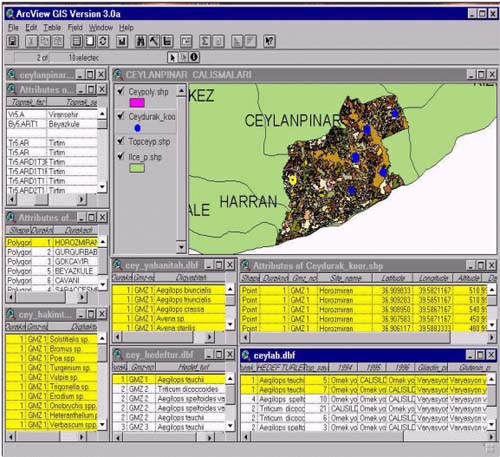
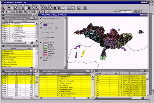
Long-term administration of the MARA GIS Center will involve a broad range of functions, from oversight of application operations to coordination of user agencies involved in maintaining various components of the agricultural database, including the "In-situ Conservation of Genetic Diversity" project. The range of potential functions provide a foundation and context for the continued development of Information Technology Management Plan (ITMP) as the administrative structure for the MARA GIS. The needs assessment has been the first step in implementing a successful GIS within MARA. In order to carry out a number of user needs interviews over a short time, the implementation staff was trained in GIS interview techniques as well as the use of a structured GIS interview form. A total of 21 organizations were interviewed during February 1998. Some details of the Information Technology Management Plan are given in the last section. DATABASE DESIGN Esri staff began the database design task with a thorough review of existing project documentation resulting from the previous project works. In particular, the user needs interviews from staff involved in the ongoing projects "In-situ Conservation of Genetic Diversity" and "Turkish Agricultural Research Project" was important in terms of defining immediate data needs. The survey of available data as well as information about interagency relationships from the draft ITMP was primary input into the definition of databases of long-term utility. Out of a detailed study of the survey of available data came an understanding of the current status of existing geographic data, both manual and digital. Based on this understanding, Esri staff and the implementation team worked toward a statement of data standards in terms of resolution, scale, projection, and use of coordinate systems. These standards included recommendations as to graphic symbolization of features, physical directory structure and how the cooperate GIS database ultimately had to be physically partitioned. Esri staff was responsible for bringing the design of all data categories into one integrated database design. This integrated design was documented in a written report form and in an on-line data dictionary as well. The starting point for the on-line data dictionary was one currently in prototype version for the ArcWorld II data product. This prototype data dictionary is a series of dBase IV tables that store descriptions, names, sources, compilation information, scale, and other metadata. It has been developed taking into account the U.S. Federal Geographic Data Committee (FGDC) metadata standards. PILOT STUDY In this project, selected target species are forest trees (cedar and fir), wild relatives of field crops (wheat, chickpea, lentils), and fruit trees (chestnut and plum. The pilot areas have been selected and described as: The Kaz Dag Area of Northwestern Aegean Region; Ceylanpinar in Southeastern Turkey; Bolkar and Aladaglar Mountains in South Turkey. Although the need of 1:25 000 scale topographic maps as base maps and digital elevation data for the pilot areas had been determined these data could not be acquired and used for this project. Instead, the following data resources that contained some base map data were automated: 1:30 000 scale soil maps for the Ceylanpinar pilot area, and 1:25 000 scale forest maps for the Kazdag Mountains pilot area. These maps were automated, referenced to UTM coordinates and link to attribute data. The presence of these base and thematic maps provided the means for the linkage of plant species related fieldwork data. Other datas related with the pilot areas were transects points and Gene Managements Zones that were intagrated to GIS by connecting all the points. Those points and their attributes are shown in figure 1 and figure 2;
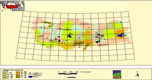
Two other important data sources used in this project were the "Turkish Geographic Database" produced by ISLEM GIS and "National Plan". The "Turkish Database" consists mainly of the following data layers: Political boundaries, settlement, drainage network, transportation and digital terrain data. The database served to reference tabular data that did not contain coordinate information (Figure 3).
The distribution of target species that were shown in the National Plan digitized and integrated to GIS. (Figure 4)
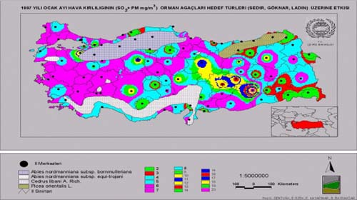
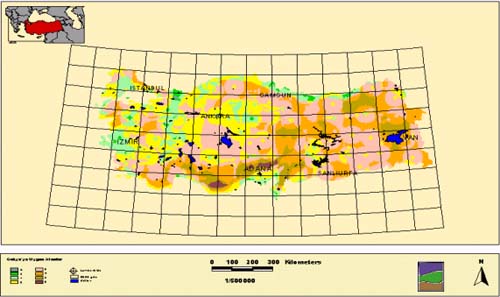
The data that were taken from ARC ATLAS II and target species maps are analyzed together to determined the gene protection and conservation area in TURKEY (Figure 5).
The need to collect all the works that had been carried during the project works gave way to the creation of an Atlas. Spatially grouped, maps showing the content of the database are followed by maps of analysis that were performed in regard of establishment and management of actual and potential Gene Management Zones (GMZ). CONCLUSION GENERAL CONSIDERATIONS Generally, it can be stated that the project had been a success in terms of reaching the overall purpose to establish the operationality of the MARA GIS Center. While a 3 million USD investment of the World Bank for founding the Center's hardware, software, and network (the biggest investment World Bank ever did in this sector) brought about nothing in respect of operation, this low-budget project created a motivated GIS team that is capable to carry out its own GIS projects. Despite being a newcomer, the MOF project team won the third award of the poster session at the 5th Turkish ArcInfo and ERDAS User Conference in June 1998. Unfortunately, World Bank funds are usually not available for projects with major consulting components like this case. ORGANIZATIONAL COOPERATION The overall interorganizational cooperation appeared to be much better as it was anticipated in the beginning. This circumstance should influence World Bank decisions on further investments in this sector positively, because it is expected that the Center should play an important role in coordinating GIS activities between the three participating ministries. According to the recommendations that are an important part of the Information Technology Management Plan "The GIS center will support the Genetic-diversity project for the three participating ministries, Ministry of Agriculture and Rural Affairs (MARA), Ministry of Forestry, (MOF), and Ministry of Environment (MOE). The GIS center must also support the broader GIS needs of the departments and research institutes of MARA." Agreements should establish the following roles for the GIS Center:"
DATA During the data inventory works it has become clear that there is a wealth of valuable data that could be useful for projects like the current one. Unfortunately, several constraints hinder the efficient use of these data and could not be included in the current project:
Currently, under the framework of a National Information System government initiatives are under way to promote data sharing between all government agencies. HARD AND SOFTWARE When the Center was established 4 years before the hardware, software, and network configuration was considered to be state-of-the-art. Due to missing project activities nearly no upgrade of the Center's system had been made since then. This resulted in a very low performance of the system in general and the PC's (all 486s) and the network in particular. Data corruption and loss was a very common problem and caused a big delay in the data automation process. Fortunately, responsible managers could be convinced that upgrade has to be done. Acquisition of new system components has already started - hopefully to be used in coming projects. |
|
|
|
[Introduction] [Conference
programme] [Presentation by authors] [Presentation by
category] |