|
| ENVIRONMENTAL ATLAS FOR THE COASTAL AREA OF FINLAND |
| Petri Porvari Finnish Environment Institute, P.O. Box 140, 00251 Helsinki, Finland, tel +358 9 4030 00,fax +358 9 4030 0390, petri.porvari@vyh.fi Abstract The GIS
(Geographic Information System) based environmental atlas
has been developed as an operative tool for oil and
chemical spill combatting and for area planning on the
coastal area of Finland. By the help of the atlas mapping
of risks, identifying sensitive resources and simulations
of accidents can be made and developing protection
strategies become easier. The atlas application allows rapid evaluations of changing scenarios and circumstances. Data from oil spill trajectory models, remotely sensed data and satellite images can be imported to the application. INTRODUCTION There is a need for maps and
qualified GIS based information of sensitive resources
for oil and chemical spill combatting. The environmental
atlas is developed for these purposes to set protection
priorities and to prevent damages to the environment but
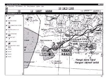
also to help area planning. Contents and implementation The environmental atlas is developed at the Finnish Environment Institute. The atlas suits as an operative tool for preventing environmental damages taking place at the coastal area. By using the atlas it is possible to see clearly all the objects and areas needing special protection. The atlas will also be used as an instrument in the area planning. Simulations of accidents and mapping of different kinds of risks will be possible. Setting protection priorities, identifying sensitive resources and developing protection strategies will become easier. Oil spill combatting and research officers on duty, environmental protection authorities, fire and rescue departments will be some of the potential users of the environmental atlas. The data collecting has been started from the coastal area of Finland, but the final version of the atlas will also comprise Lake Saimaa, which has a quite heavy oil transporting. The atlas could also be used in accidents occurring on the land. The environmental atlas is used by modified ArcView 3.0 software. With the simple and user-friendly user interface it is possible to visualise, explore, query and analyse data (Fig. 1). When the environmental atlas is completed the data will be stored on CD-ROM and distributed to users.
Data included in the environmental atlas Sensitive biological resources:
Shoreline information
Infrastructural information:
Textual and tabular information are
linked to the maps so that maps include details of
protected areas, lists of threatened species, contact
information of area owners and local experts etc. Clear
pictographic symbols are used, scales are flexible and
printing, in whatever scale, is possible. The utilisation of the environmental atlas and continual steps The atlas is easily altered and updated. It is specially planned for oil and chemical spill prevention. Data from oil spill trajectory models can be imported into the application. For example in the case of oil accident the environmental atlas shows at the first phase the most important resources in all possible directions the oil slick may drift. At the later stage of the spill the oil may drift towards a particular section of the coastline, notably an area of priority protection. In that case detailed operational maps and information for clean-up teams are needed. The GIS application allows rapid
evaluations of changing scenarios and circumstances. In
the future remotely sensed data and satellite images
could be linked to the environmental atlas. Conclusions The environmental atlas needs further developing to meet all those needs of oil combatting. The experience from using the atlas in practise will give ideas for developing. |