 Contours
of the total VOCs (Figure 5, right) were also included so data users could
overlay changing plume shapes with time, and compare VOC distribution with
ground-water flow patterns.
Contours
of the total VOCs (Figure 5, right) were also included so data users could
overlay changing plume shapes with time, and compare VOC distribution with
ground-water flow patterns.INTEGRATING ARCVIEW GIS WITH OTHER APPLICATIONS TO BETTER MANAGE AND VISUALIZE ENVIRONMENTAL DATA
Bai Tian, P.G. and Peter Nimmer, P.G.
EA Engineering, Science, and Technology
, 3 Washington Center, Newburgh, NY 12550ABSTRACT
The interpretation of environmental data, particularly ground-water data, requires an understanding of the three-dimensional distribution of contaminants and the temporal changes. Identification and tracking of temporal changes in contaminant concentrations is critical for assessment of ground-water plume movement, likely migration pathways, and for designing and/or refining ground-water extraction systems to capture and remove contaminants.
At Naval Air Station (NAS), Brunswick, Maine, a ground-water sampling program has been conducted by the U.S. Navy since 1995. The primary goal of this sampling network is to monitor changing conditions within a ground-water aquifer impacted by dissolved-phase volatile organic compounds (VOCs). Ground-water sampling has been conducted at 40 monitoring wells during 16 sampling events, resulting in the generation of more than 120,000 data records of chemical concentrations.
 To
allow decision-makers to access and visualize these data, EA integrated ArcView
GIS with several other software applications, including Groundwater Modeling
System (GMS 3.0) by Brigham Young University, EquIS Geology by EarthSoft, and
RockWorks99 by RockWare.
To
allow decision-makers to access and visualize these data, EA integrated ArcView
GIS with several other software applications, including Groundwater Modeling
System (GMS 3.0) by Brigham Young University, EquIS Geology by EarthSoft, and
RockWorks99 by RockWare.
INTRODUCTION
Long-term monitoring is widely used to assess the effectiveness of remedial measures, and monitor changes in contaminant concentrations in ground-water plumes.
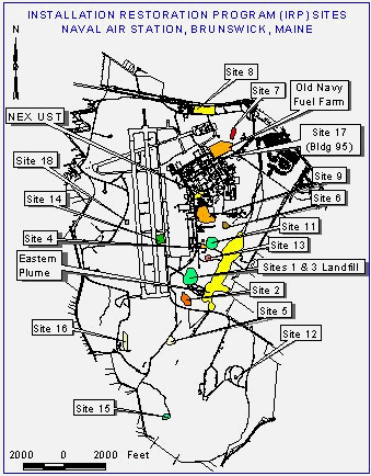
Since 1995, EA Engineering, Science, and Technology has been contracted by Northern Division, Naval Facilities Engineering Command to complete long-term monitoring at NAS Brunswick, Maine. The main purpose of this project is to monitor the distribution of dissolved VOCs in the Eastern Plume site, including TCE, PCE, 1,1,1-TCA, and DCE in ground water. The Navy has an operating pump and treat system in place to remove ground-water contaminants, and maintain hydraulic control of the VOC plume. Figure 1 (right) shows the major investigation and remediation sites and the approximate boundary of the Eastern Plume.
IMPLEMENTATION
The major visualizations that were generated to facilitate use of long-term monitoring data included generation of 3-D representation of surface topography, site geology and hydrogeology, and temporal changes in ground-water contaminant concentrations.
3-D Representation of Site Topography
Using ArcView 3D Analyst, 3D topographic maps (Figure 2, below) of the study area were generated from USGS 7.5-minute quadrangle Digital Elevation Model data. The pink area in Figure 2 represents the approximate extent of the Eastern Plume. From this 3D model, animation files were generated so data users could visualize surface topography, and the relative distances of the Eastern Plume to nearby coastal areas. These spatial relationships are useful for understanding ground-water plume position relative to potential offsite receptors and property owners.

3-D Visualization of Site Geology and Hydrogeology
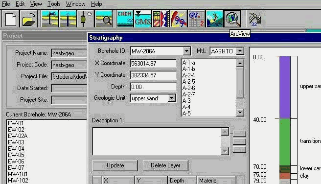
EquIS Geology was selected for use because this software has relatively easy-to-use interfaces to ArcView GIS, GMS, RockWorks, and other applications (Figure 3, below). Therefore, existing site data could be shared between applications with minimal effort. The geologic data from approximately 400 boring logs at the site were entered into an EquIS Geology database. These data could then be used to generate 2D and 3D representations of site geologic strata.
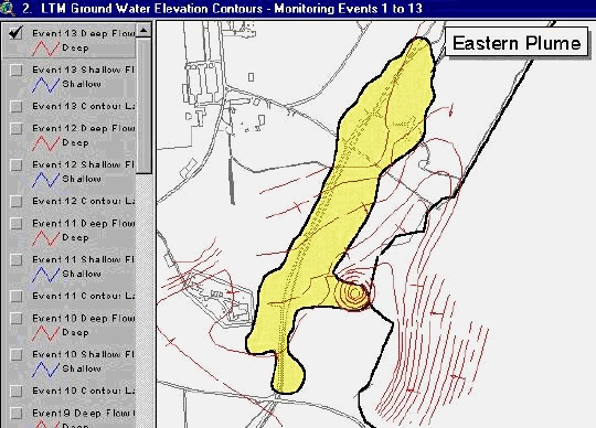
Water table contour maps were also added into the ArcView project to allow data users to quickly review changing ground-water flow patterns with time (Figure 4, below). The ground-water contours were originally generated with CAD programs and imported into ArcView GIS.
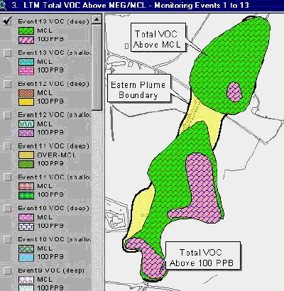
Contours
of the total VOCs (Figure 5, right) were also included so data users could
overlay changing plume shapes with time, and compare VOC distribution with
ground-water flow patterns.
The distribution and transport of the contaminants are heavily influenced by the geology of the Eastern Plume area. In the Eastern Plume area, many sampling points were installed to collect geologic data, such as the major geologic units and their thickness, geophysical conductivity, and ground-water elevation.
It is very helpful for the data users to be able to select a sampling point and directly view its geologic log, draw a cross-section line through the wells on the GIS map and see the 3D cross-sections and fence diagrams, and select the wells and get a 3D stratigraphy model. This is made possible by the ArcView interface of EquIS Geology, from which GMS, RockWorks, and LogPlot programs can be launched to create geologic boring logs, cross-sections, fence diagrams, and 3D solid stratigraphy models.
Figure 6 (below) shows the three-dimensional stratigraphy of the Eastern Plume area, which was generated from data exported into GMS borehole data format. GMS allows for the creation of the geologic unit solid models, which can be viewed in 3D from various angles. This 3D visualization allows the data user to rotate site geologic units in space, and greatly enhances understanding of the geometry of water-bearing units that transport ground-water contamination. Therefore, the distribution of site geologic units (including thickness and spatial variation) is very important to delineate the three-dimensional distribution and transportation of the Eastern Plume.
To permit visualization of site geology relative to surface features, the USGS 7.5-minute Brunswick Digital Raster Graphic quadrangle map was draped over the surface of the 3D stratigraphy model. Once constructed, cross-sections and fence diagrams can be cut from this 3D solid model to better visualize the spatial variation of the geologic units.
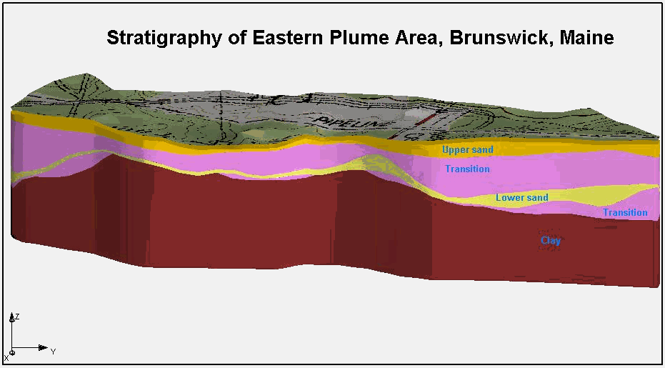
Within the EquIS Geology ArcView interface, the user can also draw cross-section lines on the 2D map and view the 3D geologic cross-sections and fence diagrams as shown on Figure 7 below. This figures shows a north-to-south geologic cross-section of the Eastern Plume area, created with RockWorks99 with the data exported from EquIS Geology database. The geologic units from top to bottom are the Upper sand, Transition, Lower sand, Clay (confirmed and inferred), and/or Transition, similar to Figure 6 above. The screen intervals of the extraction and monitoring wells are also shown in this cross-section.
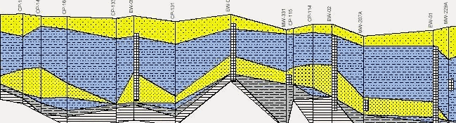
From the 3D stratigraphy model (Figure 6) and the cross-section (Figure 7), the following interpretations can be made:
In the Eastern Plume area, there are four major geologic units, i.e., the Upper sand, Transition, Lower sand, and Clay.
The Lower sand layer thins toward the northern and southern sides of the Eastern Plume. This unit is the major layer transporting the impacted ground water of the Eastern Plume. As can be seen in this visualization, the lower sand unit is confined between two lower-permeable units (the Transition and the Clay). This has resulted in limited migration of the plume outside the area, which contains the lower sand unit.
The Clay layer beneath the Lower sand serves as a natural barrier to prevent the plume from migrating further downward. This has likely been an important factor, which has limited migration of the Eastern Plume into the underlying bedrock.
3-D Visualization of Contaminant Concentrations with Time
Using GMS, a 3D animation model of the Eastern Plume was created (Figure 8, below) to show the variation of the plume over a 4-year period. As the animation shows, the plume changes magnitude
with time, and can be divided into the northern and southern lobes. This visualization also shows the extent of the plume has not changed significantly along the southern boundary, and does not show flow towards offsite receptors, south of the Eastern Plume area.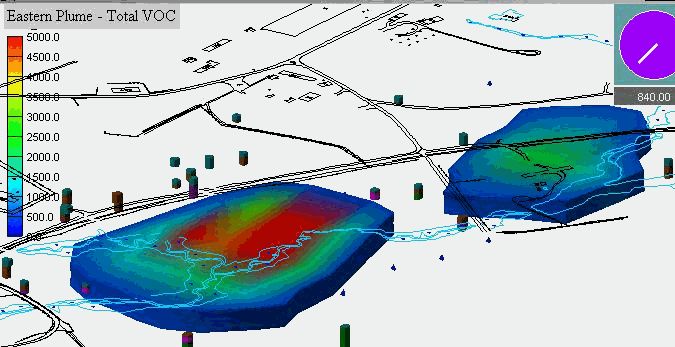
CONCLUSIONS
With the easy-to-use interface, ArcView and other related software programs were used to assist decision-makers interpret geological and environmental data. Three-dimensional visualizations of NAS Brunswick, Maine are highly useful for analyzing and interpreting complex data sets.
Our case study shows that by integrating ArcView GIS with other applications, such as EquIS Geology, GMS, RockWorks, and AutoCAD, useful interpretations were made from the large amount of the data collected between 1995 and 2000. These interpretations are used to make decisions related to environmental cleanup engineering design.
ACKNOWLEDGMENTS
REFERENCES