INTRODUCTION
Restricted to the sandy soils and open pine savannas of Polk, Tyler and Hardin Counties in east Texas, Texas Trailing Phlox (Phlox nivalis ssp. texensis) is now known from fewer than 20 documented populations (Texas Parks and Wildlife Department 1997). Texas Trailing Phlox is threatened with extinction due to habitat loss associated with forestry activities, housing developments, and agricultural activities, as well as canopy closure, fire suppression, herbicide drift, off-road vehicle use, and pipeline, power line, railroad and highway construction (U.S. Fish and Wildlife Service 1995). The species was listed as endangered by the U.S. Fish and Wildlife Service on September 30, 1991. This study assesses the feasibility of identifying potential habitat for Texas Trailing Phlox by using a geographic information systems (GIS) approach combining Landsat Thematic Mapper (TM) data and ancillary biophysical data.
Numerous studies have integrated satellite remote sensing and geographic information systems for the general purposes of vegetation mapping or for delineating specific habitats of interest (Talbot 1986; Ormsby and Lunetta 1987; Podolsky and Conkling 1992; Congalton et al. 1993; Congalton et al. 1993; Green et al. 1993; Herr and Queen 1993; Narumalani et al. 1993; Plumb 1993; Ahmad and Hill 1994; Roseberry et al. 1994; Myers et al. 1996; Sperduto and Congalton 1996; Bian and West 1997). However, few studies have used automated techniques for delineating specific component species of the herbaceous (groundcover) layer in forested landscapes. The benefits of using automated approaches include increased ability for small scale (large area) analysis and lower costs per acre-characterized (Congalton 1993). Successful spectral characterization of a species' habitat first requires that such habitat be accurately characterized on the ground. Therefore, any attempt to classify such habitat from remotely sensed data must follow the development of a proven habitat model for the species of interest.
TEXAS TRAILING PHLOX AND LONGLEAF PINE SAVANNAS
Parker and Warnock (1993) characterized Texas Trailing Phlox habitat in terms of vegetative structure as well as by floristic composition. Their work confirmed that the preferred habitat for Texas Trailing Phlox consists of relatively open stands of Longleaf Pine (Pinus palustris) on dry, flat, uplands. These structural characteristics define what is often referred to as Longleaf Pine savanna. The classic savanna structure consists of a relatively open canopy dominated by pine, with a well developed groundcover layer and sparse or absent understory (Diamond et al. 1987).
The purpose of this study was to test an automated methodology for identifying potential habitat for Texas Trailing Phlox. Because Texas Trailing Phlox occurs only in savanna conditions, this study was also generally concerned with the identification of remnant savannas. However, only those savanna sites meeting very narrow soils criteria will also support Texas Trailing Phlox (Parker and Warnock 1993). Accordingly, two classifications were produced. The first, not constrained by the soils criteria for Texas Trailing Phlox, was intended only to indicate those areas that potentially represent remnant Longleaf Pine savannas based on spectral and topographic criteria. The second classification constrained the initial classification to sites that also fell within the preferred soils for Texas Trailing Phlox, and thus represents a prediction of potential Texas Trailing Phlox habitat.
Because Landsat TM imagery has relatively coarse spatial resolution (30 meters) each picture element (pixel) within the scene represents a mixture of reflectance features, such as canopy, shrub layer, groundcover and soil. Moreover, an area as large as a forest stand represents a heterogeneous mixture of these "mixed" pixels. Accordingly, from an operational perspective, this study was primarily concerned with correctly identifying a representative vegetation structure, as identified by Parker and Warnock (1993), rather than any particular species per se.
The spatial extent of this study centered on the historic range of Texas Trailing Phlox, which corresponds to Hardin, Tyler, and Polk counties in East Texas (Figure 1). Covering a land area of approximately 2874.5 square miles, this area is often referred to as the Longleaf Pine region of the West Gulf Coastal Plain. The climate in this region is humid subtropical with frequent convectional thunderstorms occurring during summer months. These summer storms are often associated with lightening-induced ground fires (Harcombe et al. 1993). Such fires are believed to have been an important factor influencing the pre-settlement landscape of this region (Bridges and Orzell 1989). Dry upland sites in this region may have, prior to logging, been dominated by Longleaf Pine savannas, a community type that presently is restricted to upland sites maintained by fire (Diamond et al. 1987). Harcombe et al. (1993) reported that the interaction between fire and soil type may be the primary determinant of plant community distribution in this region.
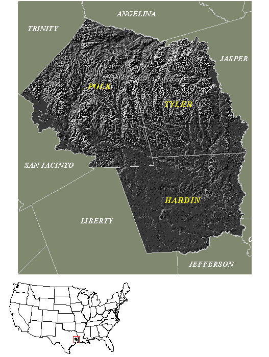
Figure 1. Study Area
DATA AND METHODOLOGY
DEVELOPMENT OF TRAINING DATA FOR SUPERVISED CLASSIFICATION
Collection of field data for this study centered on characterizing sites by measuring key habitat variables previously identified by Parker and Warnock (1993) as critical for the reproductive success of Texas Trailing Phlox. Table 1 summarizes critical habitat variables associated with reproductive success of Texas Trailing Phlox as reported by Parker and Warnock (1993).
|
Overstory Coverage |
Poor > 80% |
Tolerated 25 - 80% |
Optimal 5 - 25% |
|
Understory Coverage |
not given |
not given |
25 - 70% |
|
Shrub Layer Coverage |
80 - 90% |
25 - 40% |
10 - 25% |
|
Groundcover Coverage |
not given |
not given |
25 - 70% |
|
Slope |
not given |
not given |
< 5% |
|
Soils |
Deep sands |
Deep sands |
Deep sands |
|
Elevation |
not given |
not given |
9 - 75m |
|
Topography |
not given |
not given |
Approx. Level |
|
Timing since Last Burn |
> 5 years |
4 - 5 years |
0 - 4 years |
Table 1. Key habitat characteristics for Texas Trailing Phlox as identified by Parker and Warnock (1993).
Selection of training sites for this study was based on following four criteria:
The sites should be geographically distributed to include the full historic range of Texas Trailing Phlox.
The sites should include a representative variety of the typical savanna types found within the study area with respect to vegetative closure.
To ensure that conditions on the ground closely match the conditions at the time of scene acquisition (September 1991), the management history should be known for all selected sites.
Based on these criteria, four sites were recommended by Texas Parks and Wildlife staff (Maxey 1999) - the Roy E. Larsen Sandyland Sanctuary (managed by the Nature Conservancy of Texas) in north-central Hardin county, the Longleaf Woodland Trail (managed by Champion International, Inc.) in northeast Polk County, Woodpecker Hill (managed by Louisiana Pacific) in central Tyler County, and a site in northwest Tyler County referred to as the Champion MOU (managed by Champion International, Inc.). All sites were on dry level uplands containing a significant Longleaf component. The sites were evenly distributed along an arc from northeast Polk County to north- central Hardin County, and included open, moderately open, and closed sites with respect to vegetative cover.
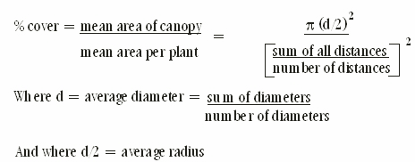
Precise determination of relative closure of sites was determined by using the point quarter method as described by Parker and Warnock (1993). In the point quarter method, a series of random points are located along a compass line within the sample site. The area surrounding each point is then divided into four equal parts (quadrants) and the overstory plant within each quadrant that is closest to the sampling point is located. Species name, basal diameter (or canopy diameter) and distance from the point are recorded for all such plants. This process is then repeated for understory and shrub layers respectively. Data collected using this methodology were used to calculate overstory coverage, understory coverage, and shrub layer coverage. Percent groundcover was visually estimated using a Daubenmire frame (a 20cm x 50cm frame that is randomly dropped within each quadrant) (Daubenmire and Daubenmire 1968). Percent coverage was calculated from the field data using the following equation:
Field sampling was conducted from June 9, 1999 through June 11, 1999. Although it was hoped that no less than 10 points (with their associated quadrants) would be sampled per site, time constraints greatly reduced field sampling. Table 2 lists the results of the field sampling, as well as percent slope (ascertained by plotting the training data on digital elevation models), and timing since last burn (TSLB). Note that most sites comported with the range of optimal to tolerated habitat as reported by Parker and Warnock (1993; Table 1), with the exception of Longleaf Woodland Trail, which had a closed canopy (this site apparently had not been burned within the previous five years). The low percent coverage for shrub and groundcover reported for most sites may be due to undersampling, or to a subtle difference in methodology from that used by Parker and Warnock (1993). It is important to note that only one of the sites, the Sandyland Sanctuary, supported significant populations of Texas Trailing Phlox.
RESULTS: Field Data
|
LLWoodTr (n = 4) |
%Overstory 100 |
%Understory 19 |
%Shrub 12 |
%Groundcover 21-40 |
TSLB >5 yr. |
%Slope 2.8 |
|
Sandyland
(n = 10)
|
49
|
11
|
3
|
21-40
|
5 yr
|
0.1
|
|
Woodp. Hill
(n = 5)
|
33
|
2
|
7
|
96-100
|
<1yr
|
1.2
|
|
Cham MOU (n
= 4)
|
80
|
11
|
16
|
21-40
|
unknown
|
1.0
|
Table 2. Key habitat characteristics as measured for training sites.
Note: n represents the number of random sampling points per training site. Each point contained four quadrant and therefore contained four samples. The total number of samples per site therefore = 4n.
The remaining sites were sampled as they represent a characteristic structural range for savanna type communities in this region (Maxey 1999). These data therefore are best interpreted as an ordinal grouping of Longleaf sites with respect to how closely each approximates classic savanna conditions. Finally, it should be noted that inspection of the sample points for the Champion MOU site (when registered to Digital Orthophoto Quads--DOQs) indicated that the selection of sample sites might have been significantly non-random with respect to cover type. Therefore the cover statistics reported here may not be reliable for this site.
All field sites were surveyed using TrimbleT GeoExplorer global positioning system (GPS) receivers. After field collection, the raw positional data were differentially corrected and exported using Pathfinder OfficeT post-processing software. Base station data used for post-processing differential correction were obtained from the Texas Department of Transportation (N.A. 1999a). The differentially corrected GPS data were then registered to DOQs for heads-up digitizing of the corresponding training site perimeters.
TRAINING STATISTICS
The three training sites used for signature extraction and supervised classification are illustrated in Figure 2. The Champion MOU site was not used for the classification because, as discussed above, inspection of the sample points (when registered to DOQs) indicated that the cover data generated for this site might not be reliable. Accordingly, training statistics were not developed for this site. Note also that although the Longleaf Woodland Trail site is closed (100 % overstory) and accordingly does not meet the structural criteria for Trailing Phlox habitat, its signature was extracted and evaluated to ensure that separability between open and closed sites could be evaluated.
Separability analysis is used to determine which band combinations optimize the spectral separability or spectral distance between the training signatures, thus reducing the probability of overlap and confusion between the resulting classes (Jensen 1996). For this study, a transformed divergence separability analysis was conducted on the signature files. Based on the results of the separability analysis, all six bands were entered into the classification.
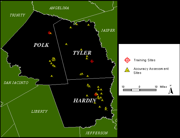
Figure 2. Training Sites and Accurracy Assessment Sites
CLASSIFICATION
This study used a Landsat 5 Thematic Mapper (TM) scene, excluding band 6, acquired on September 22, 1991 and currently archived in the Texas Parks and Wildlife Department GIS lab. The use of such dated imagery was necessitated by the lack of funds for acquisition of current imagery. While we appreciate the fact that use of such dated imagery prohibits reliable accuracy assessment, and therefore limits the reliability of the classification, these data were considered appropriate for use in this study, which sought only to determine the feasibility of supplementing current methods of habitat prediction with a more automated approach. The use of fall imagery was considered ideal, as frontal passages beginning in late September provide for relatively cloud-free conditions along the Texas gulf coast. Moreover, as our interest was in testing the spectral identification of savanna habitats, we required imagery that provided spectral returns from all vertical strata within the habitat - soil background, herbaceous, understory, midstory and canopy.
The Landsat TM data used for this study corresponds to an area that includes all of the potential range of Texas Trailing Phlox except for a small portion of northern Polk and Tyler counties that was not within the scene. Dr. Changxiang Liu, of Texas Parks and Wildlife Department rectified the Landsat scene by entering ground control points (taken from USGS 7.5' Digital Raster Graphics files) along with USGS three arc-second digital elevation models (corresponding to the TM scene) into a geocorrection model (ERDAS Imagine geocorrection tools). An accuracy assessment of the rectification was accomplished by registering 1m DOQs to the rectified TM scene and visually inspecting registration of well defined linear features. Based on this assessment, the TM scene was well within + 0.5 pixels (+ 15 m) positional accuracy. Prior to classification, the rectified TM scene was subset to an area encompassing the extent of Polk, Tyler, and Hardin counties. A parallelepiped decision rule was used to guide the classification. Overlapping pixels were classified according to a minimum distance to means decision rule.
INPUT OF ANCILLARY DATA
Classification constrained by slope
Marks and Harcombe (1981) reported that slope, elevation, and soil texture were highly colinear for the Longleaf Pine savannas they studied. For predicting Texas Trailing Phlox, use of soils criteria would obviate the need to consider elevation and slope, as the preferred soils for Texas Trailing Phlox are found only on xeric, flat, uplands. However, because the relationship between landform and upland Longleaf sites is known to be strongly biased toward gently sloping or flat sites (Marks and Harcombe 1981, Parker and Warnock 1993), slope data were used in this study to help refine the supervised classification of pine savannas. According to Marks and Harcombe (1981), slope for the savanna habitat type averages 3% + 2.4%. Slopes for the sites used in this study ranged from 0.1% to 2.8%, well within the range reported by Marks and Harcombe (1981).
This study utilized the U.S. Geological Survey (USGS) National Elevation Data Set (NED) as well as USGS 7.5' (30m) Digital Elevation Models (DEMs) corresponding to the study area. The NED elevation grids encompassing the TM scene were mosaicked, projected to an Albers Equal Area projection, subsetted, and rectified to the map extent of the TM subscene (using the corner coordinates of the TM data). The elevation data were then visually inspected to ensure pixel-to-pixel registration with the TM data. After visual inspection, data containing probable systematic error were removed from the elevation data set. The remaining elevation data set was clipped to the boundaries of the study area, then re-checked for pixel-to-pixel registration with the TM data. The final elevation grid was then converted to a slope model.
Using an overlay operation, the slope model was used to further constrain the multispectral classification to pixels corresponding to slopes of 5% or less. A Boolean query was used to select all pixels from the initial multispectral classification that registered with pixels having slopes of 5% or less. Pixels not meeting the slope criteria were coded as no-data cells.
Classification constrained by slope and soils criteria
In addition to vegetative and topographic variables, Parker and Warnock (1993) listed soils as a key variable affecting the distribution of Texas Trailing Phlox. Texas Trailing Phlox occurs on sandy soils, coupled with moisture bearing clays or sandy clays. Accordingly, this study utilized the Soil Survey Geographic data base (SSURGO) and associated flat map sheets provided by The Natural Resources Conservation Service (NRCS) to delineate the boundaries of potential soils for Texas Trailing Phlox. No SSURGO data were available for Tyler County. Data for Polk and Hardin counties were available, however data for Polk County were not available in digital form and thus had to be created from hard-copy maps.
Because Texas Trailing Phlox is restricted to specific soil types (Parker and Warnock 1993), any pixels classified as habitat that occur outside these soil types can be assumed to be in error (error of commission). Accordingly, using an overlay operation, polygons representing the boundaries of the preferred soils for Texas Trailing Phlox were used to select those pixels from the prior classification (based on reflectance and slope) that also satisfied the soils criteria. A Boolean query was constructed to select all pixels from the initial multispectral classification that occurred within the appropriate polygons of the soils coverage. The remaining pixels were re-coded as no data.
ACCURACY ASSESSMENT
The accuracy assessment used for this study is typically referred to as producer's accuracy. Producer's accuracy measures the classifier's ability to detect the class of interest by checking the classification against known locations for that class. Conversely, errors of commission, often referred to as user's accuracy, measures the probability that a given classified pixel is actually represented by that class on the ground (Congalton 1991). Because the multispectral data used in this study were dated to 1991, any mismatch between current groundcover and the reported classification could most likely be attributed to landuse/ landcover changes since acquisition of the imagery. Accordingly, ground-truthing of the classification was not attempted, and therefore, user's accuracy could not be estimated.
The Biological Conservation Database (BCD) for Texas was queried to extract a reference data set containing records (point data) for all known locations of Texas Trailing Phlox as well as species or communities associated with Texas Trailing Phlox or Longleaf Pine savannas. The BCD System is an information management tool developed and supported by the Nature Conservancy, a non-profit organization. A primary application of the BCD system is for inventorying and tracking endangered species, threatened species, and species or natural communities of management concern (N.A. 1999b). The BCD data used for this study were collected between 1979 and 1995. Only those BCD data verified as positionally accurate to three arc-seconds (the maximum positional accuracy for BCD data) were used for this study.
Table 3 lists the record categories (by common name) as well as the number of records per category extracted from the BCD for use in the accuracy assessment. The BCD sites used for accuracy assessment were well distributed throughout the study area, with 17 sites in Polk County, 11 sites in Tyler county and 26 sites in Hardin County (Figure 2).
|
Record Category by Common Name
Texas Trailing Phlox |
Number of Records
10sites |
| Longleaf Pine - Little Bluestem Series |
2 sites
|
| Longleaf Pine - Beakrush Series |
6 sites
|
| White Firewheel |
3 Sites
|
| Slender Gay-feather |
2 sites
|
| Scarlet Catchfly |
15 sites
|
| Red-Cockaded Woodpecker |
16 sites
|
Table 3. Summary of Records Extracted from BCD for Accuracy Assessment
The BCD reference data were used to check the accuracy of the habitat predictions for Longleaf Pine savannas and Texas Trailing Phlox by first buffering each BCD data point to 90m to account for the reported three arc-second positional accuracy of the data. After registering the BCD data to the classifications, each BCD point was inspected to determine if one or more pixels classified as open savanna (i.e. Sandyland or Woodpecker Hill type) were contained within, or intersected, the buffer. Any buffer containing or intersecting at least one classified pixel was recorded as a "hit". Any buffer not containing or intersecting at least one classified pixel was recorded as a "miss".
RESULTS AND DISCUSSION
CLASSIFICATION
Figure 3 illustrates the results of the supervised classification constrained by slope. This map therefore represents a prediction of Longleaf Pine savannas based on spectral and topographic criteria. Because the open savanna habitat type is the relevant class with respect to predicting Texas Trailing Phlox, only the two open savanna type classes are represented - the class corresponding to the Sandyland Sanctuary training site, and the class corresponding to the Woodpecker Hill Training site. The Longleaf Woodland Trail class, having 100% canopy closure, by definition is not a savanna type and therefore was not mapped, nor was it included in any subsequent accuracy assessment.
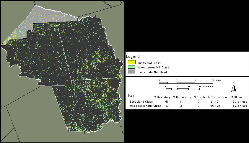
Figure 3. Predicted Longleaf Pine Savannas
Figures 4 and 5 contain all pixels from the slope-constrained classification, described above, that also satisfy the soils criteria for Texas Trailing Phlox. Accordingly, based on the habitat prediction model used for this study, these maps represent a habitat prediction for Texas Trailing Phlox in Polk and Hardin counties respectively. Note that because SSURGO soils data were unavailable for Tyler county any prediction of Texas Trailing Phlox habitat for Tyler county must be inferred from Map 1. If Map 1 proves to accurately predict Longleaf Pine savannas, it should also provide a reasonably coarse prediction of Texas Trailing Phlox habitat.
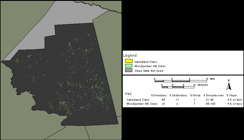
Figure 4. Predicted Texas Trailing Phlox Habitat - Polk County
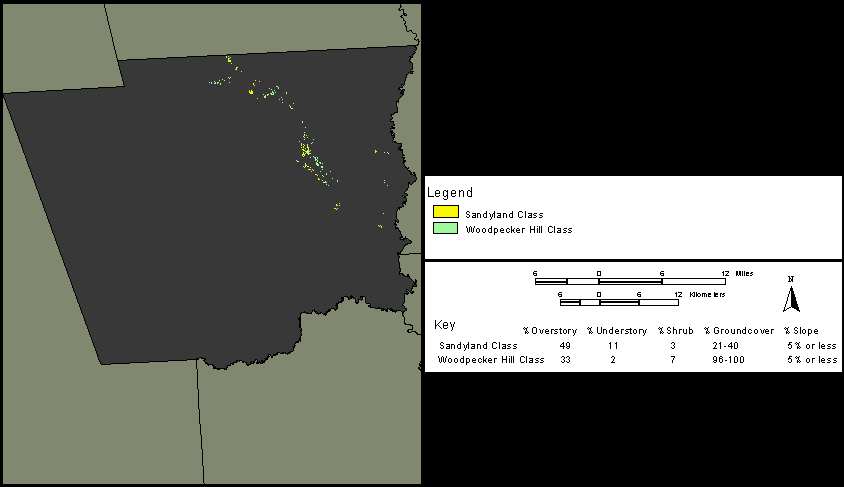
Figure 5. Predicted Texas Trailing Phlox Habitat - Hardin County
ACCURACY ASSESSMENT
Accuracy Assessment of Predicted Longleaf Pine Savanna
Of the fifty-four sites evaluated from the BCD, seven misses were found in the classification of predicted open Longleaf Pine savannas. Thus producer's accuracy for this classification equals 87 percent (47/54).
Accuracy Assessment of Predicted Texas Trailing Phlox Habitat
Of the ten sites evaluated from the BCD, three misses were found in the classification of predicted Texas Trailing Phlox Habitat resulting in a producer's accuracy for this classification of 70 percent (7/10). It should be noted, however, that inspection of the three sites missed by the classification indicated that one site occurred in a drainage, indicating that this site was of questionable accuracy. Subsequent investigation confirmed that this site was positionally inaccurate. One additional missed site was confirmed in 1987 but occurred in an area that was clearcut prior to 1991 (the acquisition date of the imagery). Eliminating these erroneous data points from the BCD reference data set, producer's accuracy equals 87.5 percent (7/8).
DISCUSSION
Simberloff (1993) observed that second-growth trees may provide the appropriate structural characteristics of the Longleaf savanna system in the absence of a well developed canopy. It is important to realize that (due to the management practices of private and public timber interests) for many sites in the Longleaf region of East Texas, second growth stands on dry upland pine sites are often dominated by Loblolly Pine (Pinus taeda), Slash Pine (Pinus elliottii) or Shortleaf Pine (Pinus echinata). Nonetheless, depending on fire frequency, patch size and other landscape metrics, many of these second-growth sites may closely resemble the classic structure of Longleaf savanna, albeit with the Longleaf component largely replaced (Harcombe et al. 1993). This observation is relevant to the results reported here, as it is very likely that from the perspective of the TM sensor, Longleaf Pine, Slash Pine and Loblolly Pine all have similar reflectance characteristics. Consequently, the prediction of Longleaf Pine savannas reported here should be accepted with the understanding that even if the savanna-type structure has been accurately identified, many of these savannas may have little or no Longleaf present.
The separability analysis indicated that the two open savanna classes were not spectrally separable. This problem likely resulted from the small number of training sites used. Non-homogeneous environmental conditions may have additionally affected the spectral response patterns of the classes throughout the study area (Jensen 1996).
Inspection of the habitat prediction maps produced by this study indicates that some lowland areas were classified as savanna. Based on prior groundwork in this area, it is likely that these are wet savannas typical of many lowland areas in this region. Moreover, numerous linear features were classified as Trailing Phlox habitat. Most of these areas probably represent road cuts, logging roads, power lines, or firebreaks on sandy soils. A number of confirmed Texas Trailing Phlox populations are known to be associated with such features. Accordingly these features were not masked or filtered out of the classification. In sum, future studies will need to determine the exact nature of these features as well as their potential association with Texas Trailing Phlox.
It is important to note that the sample size used for the accuracy assessment in this study was strictly limited by the availability of current and accurate reference data. The issue of valid sample size has received considerable attention in the literature concerning accuracy assessment of remotely sensed data. Generally, for a typical satellite scene, a minimum of fifty pixels per class is considered a valid sample for checking classification accuracy (Congalton 1991; Jensen 1996). The accuracy assessment reported here for the Longleaf Pine savanna classification therefore meets the minimum accepted sample size for classification accuracy assessment. However, the accuracy reported for the Texas Trailing Phlox habitat classification should be accepted with caution due to the small sample size used.
Finally, until this study can be replicated using more current imagery, ground-truthing will be of little use for determining the capabilities of the classification methodology. Until such complete accuracy data can be generated, however, the reliability of this classification methodology cannot be fully assessed. Nevertheless, the reported results for producer's accuracy indicate that repeating this study using current imagery would be well worth the effort and expense.
CONCLUSIONS
The need for rapid, cost-effective land cover characterization is made increasingly urgent by the steady increase in species losses associated with habitat conversion. In fact, according to Wilson (1988, in Sperduto and Congalton 1996) the current rate of extinction may exceed all other extinction events in the past 65 million years. Moreover, most of these species losses are due to loss of habitat (Murphy 1988, in Sperduto and Congalton 1996). This study demonstrates that the application of current geospatial technologies can greatly accelerate the location of potential habitat by substantially reducing the search area for such habitat. Consider, for example, that the total historic range of Texas Trailing Phlox equals 7444.95 square kilometers (combined land area of Polk, Tyler, and Hardin counties). The total land area predicted by this study for Longleaf Pine savannas, based on reflectance, totals only 682.19 square kilometers. By additionally considering slope criteria this area was further reduced to 666.837 square kilometers. The total combined land area for Polk and Hardin counties equals 5054.64 square kilometers. The total area predicted by this study for Texas Trailing Phlox habitat (Polk and Hardin counties), based on reflectance, slope, and soils, totals a mere 27.85 square kilometers. The time required for ground-truthing 27.85 square kilometers would be well within that provided by most endangered species recovery plans.
Successful recovery of Texas Trailing Phlox first requires successful identification of remaining habitat. This study demonstrates that an automated approach can greatly accelerate implementation of the Recovery Plan for Texas Trailing Phlox (U.S. Fish and Wildlife Service 1995) by improving chances for timely identification of such habitat throughout the species' historic range. In so doing, it is hoped that this study will lead to lower costs and increased efficiency of habitat delineation generally, so that future generations may also enjoy the diversity of the natural world, as well as the many ecological and economic benefits such biodiversity helps to ensure.
ACKNOWLEDGMENTS
This study was made possible by the generous support of the Texas Parks and Wildlife Department. The authors gratefully acknowledge Dr. Kim Ludeke of the Texas Parks and Wildlife GIS Lab for his kind support and encouragement. Landsat Thematic Mapper data used for this study was provided by the Texas GAP Program. Abundant thanks to Ricky Maxey for his expert fieldwork and to Dr. Changxiang Liu for providing the geocorrected Landsat TM scene. We thank Wendy Ledbetter of the Texas Nature Conservancy for providing access to the Roy E. Larsen Sandyland Sanctuary, David Baggett of Champion International, Inc. for providing access to Champion properties, and Gary Spencer of Louisiana Pacific for providing access to the Woodpecker Hill site.
REFERENCES
N.A. 1999a. Texas Dept. of Transportation's FTP Server. June 1999. ftp://ftp.dot.state.tx.us/pub/txdot-info/isd/gps/
N.A. 1999b. The biological and conservation data (BCD) system, January, 1999. www.tnc.org/frames/index.html?/html/list.html. Last revision, January 12, 1999.
Ahmad, Waqar , and Greg J.E. Hill. 1994. A classification strategy for mapping Trochus Shell habitat in Torres Strait, Australia. Geocarto International (3): Vol. 9, 39-47
Bian, Ling, and Eric West. 1997. GIS modeling of Elk calving habitat in a prairie environment with statistics. Photogrammetric Engineering and Remote Sensing 63 (February): 161-167.
Bridges, E. L., and S.L. Orzell. 1989. Longleaf pine communities of the West Gulf Coastal Plain. Natural Areas Journal 9: 246-263.
Congalton, R.G. 1991. A review of assessing the accuracy of classifications of remotely sensed data. Remote Sensing of Environment, 37: 35-46.
Congalton, Russell G., Kass Green, and John Teply. 1993. Mapping old growth forests on National Forest and park lands in the Pacific Northwest from remotely sensed data. Photogrammetric Engineering and Remote Sensing 59 (April): 529-535.
Congalton, Russell G., Janine M. Stenback, and Reginald H. Barrett. 1993. Mapping deer habitat suitability using remote sensing and geographic information systems. Geocarto International (3): Vol. 8, 23-33
Diamond, David D., D.H. Riskind, and S.L. Orzell. 1987. A framework for plant community classification and conservation in Texas. The Texas Journal of Science 39: 203-221
Daubenmire, R.F.and J.B. Daubenmire. 1968. Forest vegetation of Eastern Washington and Northern Idaho. Washington Agricultural Experiment Station Technical Bulletin 60. 104 pp.
ERDAS, Inc. 1997. ERDAS Imagine V8.3 Field Guide. Atlanta, GA.
Green, Kass, Steve Bernath, Lisa Lackey, Matthew Brunego, and Stuart Smith. 1993. Cumulative effects of forest practices: Where do we start? Geo Info Systems, February, 31-41.
Harcombe, P.A., J.S. Glitzenstein, R.G. Knox, S.L. Orzell, and E.L. Bridges. 1993. Vegetation of the Longleaf Pine region of the West Gulf Coastal Plain. In S.M. Herman, editor, Proceedings of the Tall Timbers Fire Ecology Conference No 18. Tall Timbers Research Station, Tallahassee, Florida.
Herr, Andrea M., and Lloyd P. Queen. 1993. Crane habitat evaluation using GIS and remote sensing. Photogrammetric Engineering and Remote Sensing 59 (October): 1531-1538.
Jensen, J.R. 1996. Introductory Digital Image Processing. A Remote Sensing Perspective. Englewood Cliffs, NJ: Prentice Hall.
Marks, P.L. and P.A. Harcombe. 1981. Forest vegetation of the Big Thicket, Southeast Texas. Ecological Monographs 51(3): 287-305.
Maxey, Rickey. 1999. Texas Parks and Wildlife Department endangered species biologist. Interview by author, 8 June, Austin, Texas.
Murphy, D.D. 1988. Challenges to biological diversity in urban areas. In E.O. Wilson, editor, Biodiversity.Washington, DC: National Academy Press.
Myers, Robyn L., Shannon McElvaney, and John C. Eberhardt. 1996. GIS in the jungle: Monitoring East Maui's rain forest changes from the ground, air and space. Geo Info Systems, November, 16-23.
Narumalani, Sunil, John R. Jensen, Miles Hayes, Jaqueline Michel, Todd Montello, and John Robinson. 1993. Using remote sensing to assess habitat in the Saudi Arabian Gulf before the Gulf War oil spill. Geo Info Systems, June, 33-41.
Ormsby, James P., and Ross S. Lunetta. 1987. Whitetail deer food availability maps from Thematic Mapper data. Photogrammetric Engineering and Remote Sensing 53 (November): 1585-1589.
Parker, Melissa and M.J. Warnock. 1993. Project No. 42: Inventory of the Texas Trailing Phlox (Phlox nivalis ssp. texensis) with Emphasis on Management Concerns. Performance report for Texas Parks and Wildlife Department.
Parks and Wildlife Code Chapter 88 § 88.001, West Group St. Paul, MN, 1997.
Plumb, Gregory A. 1993. Knowledge-based digital mapping of vegetation types in Big Bend National Park, Texas. Geocarto International (2): Vol. 8, 29-38
Podolsky, Richard, and Phillip Conkling. 1992. Satellite imagery aids analysis of rare coastal ecosystems. Geo Info Systems, June, 56-59.
Roseberry, John L., Bryan J. Richards and Thomas P. Hollenhorst. 1994. Assessing the potential impact of conservation reserve program lands on bobwhite habitat using remote sensing, GIS, and habitat modeling. Photogrammetric Engineering and Remote Sensing 60 (September): 1139-1143.
Simberloff, Daniel. 1993. Species-area and fragmentation effects on old-growth forests: Prospects for Longleaf Pine communities. In S.M. Herman, editor, Proceedings of the Tall Timbers Fire Ecology Conference No 18. Tall Timbers Research Station, Tallahassee, Florida.
Sperduto, Molly B., and Russell Congalton. 1996. Predicting rare orchid (Small Whorled Pogonia) habitat using GIS. Photogrammetric Engineering and Remote Sensing 62 (November): 1269-1279.
Talbot, Stephen S., and Carl J. Markon. 1986. Vegetation mapping of Nowitna National Wildlife Refuge, Alaska using Landsat MSS data. Photogrammetric Engineering and Remote Sensing 52 (June): 791-799.
Texas Parks and Wildlife Department. 1997. Texas Trailing Phlox (PWD LF W3000-019P).
U.S. Fish and Wildlife Service. 1995. Texas Trailing Phlox (Phlox nivalis ssp. texensis) Recovery Plan. Albuquerque, New Mexico.
Wilson, E.O. 1988. The current state of biological diversity. In E.O. Wilson, editor, Biodiversity. Washington, DC: National Academy Press.
All correspondence should be addressed to:
| Steve Schwelling |
| Texas Parks and Wildlife Department |
| 4200 Smith School Rd. |
| Austin, TX 78744 |
| ph. 512.389.8063 |
| email - steve.schwelling@tpwd.state.tx.us |