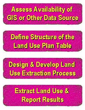
 Figure 1 Land Use Development Process |
Prins J.G. Dr., HDR Engineering, Inc. and Bodeaux, Marcie, Fairfield-Suisun Sewer District
Land use is key input to water distribution, wastewater collection, and stormwater system master plans. Most agencies have developed several data sources, including GIS data sources, which can be used in developing a land use database for master planning. ArcView GIS is a useful tool to develop a customized interface to link the master plan's land use database with the client's GIS and other data sources. This paper discusses a proven approach to developing these land use databases, and a case study to illustrate this process.
As a consulting engineering company, HDR Engineering, Inc., is contracted by cities, counties, and water and sewer agencies to conduct facility master plans, such as for water distribution systems, wastewater collection systems and stormwater systems. With the release of ArcView GIS, HDR saw an opportunity to utilize this versatile tool in the master plan development process. Not only is ArcView GIS a tool that makes GIS accessible to engineers and other non-GIS users, with its object-oriented Avenue script language it is also easily customized.
With the introduction of ArcView extensions, the customizing potential was further enhances. HDR developed a set of extensions that included a collection database management, line and node editing tools, project management functions, and standard model extraction extension for hydraulic programs, such as HYDRA, EPANet, and XPSWMM. These standard extensions are designed to facilitate customization with minimal effort and cost. A previous paper (Prins, et. al. 1998) addressed HDR's approach to minimize customizing cost by investing in developing these standard ArcView GIS extension and supporting software.
Land use is one of the most important components in the development of a hydraulic model. Typically, land use is the driving force behind the need to improve and extend the hydraulic system to provide service to the ever-growing customer base. With the land use known, it can be translated into water demand, wastewater flows, and urban runoff estimates that are fed into the hydraulic model.
If GIS data sources are available for the land use development, an ArcView GIS interface can be used to extract land use directly from these data sources. Linking the land use to GIS has several benefits:
The most important aspect of this approach is that the master plan becomes a dynamic planning tool that can be updated at regular intervals to re-assess improvement needs and the scheduling of capital improvement projects. However, to develop a land use planning tool with the robustness and flexibility to enable dynamic maintenance of master plans requires a thorough understanding of the design and data requirements of a land use extraction process.
The experience gained from developing several land use plans for several types of communities, based on a verity of data sources, resulted in a proven project approach. This following is an overview of this project approach. In conclusion, the application of this approach will be illustrated using the land use plan development process developed for the Fairfield-Suisun Sewer District (FSSD) as a case study.
Figure 1 Land Use Development Process |
The first and most important aspect to remember is that each land use development process is application specific. Each application's extraction process will depend on the available data, the format and accuracy of the data, and the available budget to develop additional data sources or to expand existing data sources. However, the basic process, as illustrated in Figure 1, remains the same and includes four distinct project components (as discussed below). These include identifying data sources, defining data structure of land use plan database, designing and developing the land use extraction process, and extracting the land use data and reporting the extraction process and land use extraction results.
Proper project planning is a key aspect in the successful development of a land use plan. It is important to invest the time and effort up front for project planning to set the roadmap for the project. This project phase should focus on characterizing the available data sources and identifying land use extraction options and the associated additional data development needs. Based on this information, the land use extraction process, including short-term (for the current project) and long-term data development programs, can be designed to reach the current project goals. The process design should be flexible to accommodate the more detailed data sources that will be developed as part of the long-term plan.
Typically, the users of the facility master plans are not community planners, but engineers. Although they understand the importance of land use in the master planning process, they seldom are fully familiar with their agency's planning efforts and the data that are maintained in this process. Therefore, it is often necessary to involve several of the agency's departments (or several agencies) in the planning effort. It is also important to involve all parties in the review and approval of the plan. Not only does that establish the credibility of the plan, it also motivates the other parties to keep their data sources current.
There are several data sources that can be used in the development of the land use plan. The more detailed and accurate the available data are, the more comprehensive and accurate the plan. However, even without any GIS data sources, the basic data sources required for the land use plan (e.g., a General Plan and a zoning coverage) can be developed in ArcView GIS with relatively low effort. The following reviews some of the more commonly available data sources.
An agency's General Plan (also referred to as a Comprehensive Plan) documents the long-term development plan for the current incorporated areas and areas outside the agency's incorporated area, but within its planning jurisdiction (or sphere of influence). The plan might include special development projects, such as a redevelopment project for a downtown area.
The development guidelines are defined in general land use categories (e.g., low, medium, and high residential developments). The land use definition for undeveloped areas is based on gross areas, which include rights-of-ways for neighborhood streets, open space, parks, schools, public services, and neighborhood commercial development.
The General Plan also includes land use and population projections. These projections are developed to estimate the agency's potential income base. Typically, these projections are based on several assumptions to develop a realistic, but conservative, financial projection.
Land use zoning and the associated zoning codes provide guidelines to developers for planning development within the agency's jurisdiction. Although there are similarities between the General and zoning land use, there are several incompatibilities that are important to the development of a land use plan. These incompatibilities include the following:
These incompatibilities have to be addressed in the design of the land use development and extraction process to generate a land use plan that is a merger of the General Plan and zoning land use.
Although zoning designations are parcel-based they do not identify the current development status of a parcel. Also, the zoning designation does not specifically define the actual development on the parcel. For example, a "mixed use" zoning designation allows development that might include medium to high density residential, commercial, offices, etc. Thus, additional data sources will have to be explored to establish the current development status of a parcel and the actual development on the parcel.
An agency’s zoning codes are often the best data source for establishing target development densities for each land use category, or the probable land use distribution for non-specific land use categories, such as "mixed use."
Parcel data can be used to estimate existing developed land use. However, it is only useful if a GIS parcel coverage is available. Typically, a parcel coverage includes at least a parcel identification number (a PIN number). The parcel's development status and the actual development on the parcel can be established in the following ways:
Although parcel-level data provide a more detailed estimate of the existing land use, this data source is seldom available or the project budget does not allow for conducting a land use inventory survey. Therefore, additional data source should be considered to establish existing land use.
Most cities maintain a traffic zone database for land use and population studies. Often this data source includes existing land use estimates and land use projections. In the absence of parcel-level data on existing land use, accumulated traffic zone data can be used to estimate existing development. The traffic zone projections are often the best data source for estimating growth projection parameters (see discussion below).
The Planning area coverage is a new data source that must be developed for the project. For land use projection purposes, the study area is subdivided into planning areas, which are delineated to represent development with similar growth characteristics. As a general guideline planning area sizes are limited to approximately 150 acres to 250 acres.
The polygon planning area theme can be developed from an existing data source, such as a Census Tract or Traffic Zone coverage. If so required, the initial polygons can be split to the required size for planning areas. Typically, these splits are done along political or zoning boundaries.
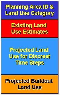 Figure 2 Data Blocks in Land Use Plan Database Table |
The planning area attributes include a planning area identification number, an annual land use growth rate, and parameters to enable phasing in of future development. It is preferable to design the planning area identifier with a link back to the polygon's source, such as the census tract or traffic zone number. This is helpful for data summary and reporting purposes.
The product from the land use extraction process is a database table (with or without an associated graphical component) that defines the existing and projected future land use development. Before designing the extraction process, it is important to define the format of the final product. The actual database structure will depend on the data processing requirements of modeling software or the process that translate the land use to model input. However, the key components (or data blocks) of land use database table, as illustrated in Figure 2, are as follows:
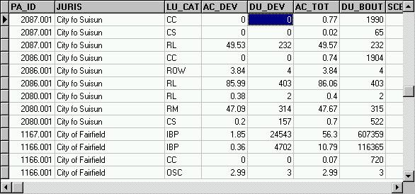
A land use record in the extracted land use plan table is identified by a planning area identifier and a land use category. Since land use is summarized by planning area and then by land use category, the land use plan table contains several records for each planning area, as illustrated in the Figure 3. Each record represents a land use category that falls within the boundary of the planning area.
|
Existing land use is expressed in dwelling units, 1,000 sf of floor area, or parcel area (in acres) depending on the land use category. Typically, existing residential land use is defined as number of developed dwelling units. Commercial and industrial land uses are measured in 1,000 sf of floor area, building footprint area, or parcel area. It is seldom possible to obtain the detailed land use data to define commercial and industrial land use in terms of 1,000 sf developed floor area. Typically, commercial and industrial land use is measured in building footprint area or gross parcel area. The same governs for offices and public buildings.
This data block includes the developed area (measured in acres) for each land use category. These measurements are based on the size of the parcels occupied by the existing land use. The developed area estimates are required for estimating storm runoff or infiltration for master planning wastewater and stormwater collection systems.
The buildout land use measurement units depend on the units selected for measuring existing land use. The buildout land use represents the ultimate land use to be served by the water distribution or collection systems. Buildout land use calculations are based on estimated future land use densities taking into account the current develop and the probable average development densities of undeveloped areas.
There are several factors to considered in developing these estimates, including:
As previously stated, General Plan and financial planning land use (and population) estimates include factors, such as under-built and limited in-fill development, to prevent over-estimation of the agency’s income base. On the other hand, facilities (e.g., water distribution lines and sewers) have to be designed with sufficient capacity to serve all probable land use within the General Plan boundaries. Therefore, it is recommended to base buildout estimates for facility master planning on zero under-built and in-fill development to the target density of the land use category. This approach will more likely provide the required system capacity to serve buildout land use and will prevent future replacement of these facilities at a later date to accommodate the needs of the actual development.
This might be a controversial approach and the land use development approach and assumptions should be properly documented. The documentation should also discuss the differences in intend and assumptions between this land use plan’s projections and other publish land use projection.
Typically, the existing land use estimates are used to calibrate hydraulic models to measured sewer inflows or water demands in the collection or distribution systems. It can also been used to define short-term system improvement requirements. The buildout land use is used to design existing system improvements and to plan future system extensions. A master plan also includes an implementation program that defines the implementation schedule of the proposed system improvements and extensions.
Interim land use projections can be developed as a tool to define the implementation program. In most application these interim projections are done for discreet 5-year or 10-year interval over a 20 to 40-year planning horizon. The projected land use for these growth scenarios can be used to simulate the projected hydraulic conditions in the systems. The hydraulic modeling results can then be used to define the scheduling of the improvement projects.
As previously discussed, the land use extraction process could be designed to facilitate dynamic updating of the land use plan and the proposed project implementation programs with any changes to the input data sources. General guidelines for the land use extraction design are as follows:
From the previous discussion it is evident that accurate estimates of the existing, buildout and interim land use projections are essential to a successful land use plan. This following discussion considers on a number of typical options for utilize existing GIS or project specific data sources in the land use extraction process. Because the previously mentioned existing land use data source are seldom available, the alternatives for developing of project specific data sources are also explored. This discussion will show that the same general land use development approach can be applied to any application independent of the current availability of GIS-based data sources.
The first step in the land use plan development is estimating the existing or developed land use. The data extraction design or land use development process for this step depends on the format of the available data sources. If often happens that an agency does not have an established GIS, but is planning to or is in the process of implementing GIS. In these cases the base land use information, such as parcel, zoning, or general plan GIS coverages are not available. Although hardcopy zoning and general plan maps might be available. The following two cases present the two extreme possibilities for estimating existing developed land use.
If no General Plan, zoning, or parcel-base GIS data sources are available, a polygon land use theme could be developed in ArcView GIS. Existing hard copy General Plan and zoning maps can be used to construct this theme. The resulting land use theme will be a merger of the General Plan and zoning information. For areas inside the current zoning boundaries the land use polygons will be attributed with zoning categories. For the areas outside the zoning boundaries General Plan land use designation should be used. The exception to this might be areas within the zoning boundaries that are earmarked for redevelopment.
The theme's attributes will include a land use category, the total (gross) acres of the polygon, the estimated developed (gross) acres, and estimated developed land use units. The latter could be counted as dwelling units, 1,000 sf floor area, net floor area, or gross parcel area depending on the land use category. Existing development can be estimated from currently available data sources (e.g., traffic zone estimates) or conducting an arial photograph or surface inventory survey.
The land use extraction process generates a land use plan database table by overlaying the planning areas on the land use theme to summarize the land use per planning area. In the land use extraction process each land use polygon is intersected with each planning area and the land use data are assigned to the planning area proportional to the intersect area.
If detailed GIS data sources (such as zoning and parcel coverages) and a parcel-base land use inventory database are available, a more comprehensive data extraction process can be developed. This process will involve overlaying the polygon planning area theme on the parcel (and zoning) coverage to select the parcels the falls within a specific planning area. The developed land use within the planning area can the extracted by considering the development status, the number of developed units, etc. for each parcel within the planning area.
Comparing the above cases to develop existing land use estimates, it is apparent that Case 1 will require more effort to maintain. Typically, the data sources used in Case 2 are maintained in the GIS system and the existing land use estimates can by re-extracted with changes to the GIS data sources.
As previously stated, the buildout land use estimates for the facility’s land use plan will most likely differ from other estimates. Therefore, the buildout estimate process will be specific to this land use plan development.
For Case 1 above, buildout estimates could be calculated and added (or directly assigned) as an attribute to the land use theme. The extraction process to summarize the assigned buildout land use per planning area is similar to that of extracting existing land use per planning area. The disadvantage of this approach is that the assign values will have to be updated with changes in land use designations and existing land use data.
Alternatively, the buildout estimates can be calculated during the land use extraction process. A lookup table must be developed that defines the target develop density for each land use category in the land use plan. The extraction process can then be design to estimate buildout land use based on a set of guidelines. The extraction process can also allow user input for selecting options (e.g., an under-built factor and criteria to allow for in-fill development) to develop multiple buildout scenarios. This approach provides more flexibility and can designed to utilize developed or available GIS data sources as identified in Case 1 and 2 above.
Once the existing and buildout land use estimates are completed, interim land use projection can be generated for discreet intervals. The projection criteria (e.g., annual growth rates, phasing in schedules, etc.) are assigned as a planning area attributes. Typically, project criteria are project specific and previously defined data sources are seldom available to use in developing these criteria. Although, traffic zone projection might be used for growth rate estimates, the projection criteria are not linked to this data source.
The land use extraction process will include a step to calculate the interim projections based on the existing and buildout land use estimates and the projection criteria. The projection calculations will be applied to each record (that represents a specific land use category in a planning area) in the land use plan table.
On completion of the land use extraction process the extracted land use should be summarized and compared to historic data and other land use projection to test the validity of the extracted land use. To establish the land use plan’s credibility, it is important to illustrate that the extracted land use and projections are in line with historic growth trends.
An important part of the land use plan development is the documentation of data sources used and assumptions made in the data extraction process and to the reporting of land use projection results. This report can then be submitted to all parties involved for review and approval.
Fairfield-Suisun Sewer District (FSSD) is responsible for collection and treatment of wastewater for the cities of Fairfield and Suisun City in California. The objective of the Sewer Master plan was to plan existing system improvements and future collection system extensions to serve the currently adopted General Plan land use of both Cities. The following summarizes the land use development process for this application.
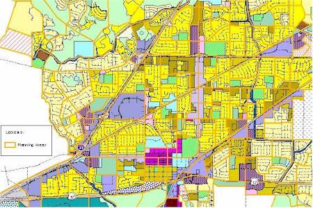
In this application, neither of the two Cities has an established GIS that include land use planning. Only hardcopy General Plan and zoning maps were available. The General Plan documentation also included several sketch plans for proposed special development projects. These hardcopy maps were used to develop a land use theme in ArcView GIS (similar to that described in Case 1 above). Because the two Cities zoning categories and the General Plan land use categories were not the same, a new set of land use categories (i.e., the land use plan categories) were defined using the City of Fairfield’s land use categories as the base set. The land use theme’s attributes included the zoning and general plan categories of both cities (as applicable) and the land use plan categories. This enabled the generation of maps that are specific to each city for their reviewing and approval prior to extracting the land use data. Figure 4 shows a sample of the land use as defined in the land use theme.
|
Both cities recently updated their traffic zone land use estimates, which include existing, buildout and projected land use data. The City of Fairfield provided a CADD drawing that defined the traffic zone delineation. Therefore, the traffic zone boundaries were selected for delineating the planning areas. However, most traffic zones were too large and had to be sub-divided. The numbering scheme for the planning area identification number was designed to include a reference to the base traffic zone.
The cities’ traffic zone land use estimates were used in this process. The land use for each traffic zone was summarized by land use category. However, these were general land use categories that were not directly related to zoning categories. The existing and buildout land use were estimated by redistributing the traffic zone data to the land use zones proportional to the intersected areas. For this process, a set of guidelines was developed to translate the more general traffic zone data to the more detailed land use plan categories. The assigned data were review against specific development data (where available) and the appropriate adjustments were made.
The cities’ traffic zone projections were used to define the initial growth projection criteria. The criteria included an annual land use growth rate and an estimate of when development of currently undeveloped areas will commence. These parameters were assigned to each planning area. The assigned projection criteria were reviewed by the Cities and were adjusted as appropriate.
A customized routine was developed to calculate the interim land use growth projections based on the land use growth criteria and the existing and buildout land use estimates.
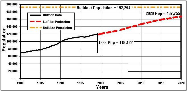
The land use was summarized for each City and for the study area. Population projections were generated using population density factors. The summarized land use and population projections were compared to historical data and General Plan and traffic zone projections to establish the credibility of the land use plan. Figure 5 shows the projected and buildout population relative to the historic population data. This figure illustrates that the land use plan’s projection is a continuation of the historic growth trend.
|
This objective of this paper was to provide an overview of the process to develop a land use plan for water and wastewater master plans and to illustrate this process with a case study. The land use plan for the FFSD Sewer Master Plan was developed with no available land use GIS data sources, and limited information on existing development. However, by following basic land use development approach defined in this paper, we were able to generate a realistic land use plan with a projected growth trend similar to that seen in historical data.
This same approach has been used to develop land use plans for several applications, from major cities to rural communities. Even though the format of data sources differs substantially between applications, the results always proved to compare favorably with historic growth trends and other projections.
Thanks to Fairfield-Suisun Sewer District for allowing us to use their project as a case study.
Prins, J.G. Dr, Reil, J.R., Madison, M.J, and Swimley, C.E., Develop a Sewer Master Plan with a Dynamic Link to GIS Using ArcView, Esri User's Conference (1998), San Diago, CA.
Dr J.G.
"Koos" Prins is a Senior Professional Associate at HDR Engineering,
Inc.
Marcie Bodeaux is a Senior Environmental Engineer at Fairfield-Suisun Sewer
District.