Implementing a Countywide GIS – Strategies and Accomplishments
A
BSTRACT: The County of Chester, Pennsylvania has been in the process of implementing a geographic information system (GIS) for the past seven years. The project initiated with the establishment of a project team consisting of county staff and a consultant company to mange the GIS implementation. The team was charged with the implementation of the GIS with development of some reengineering processes for departments involved with land records transactions. Two committees, Policy and Technical, consisting of representatives from various departments, were also formed to assist in the GIS implementation. The people involved and their approach to project management and decision making established commitment for project completion. This paper describes the project management strategies; accomplishments and lessons learned in implementing a countywide GIS.INTRODUCTION
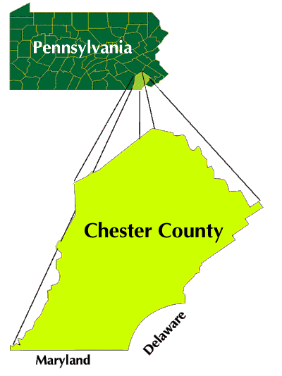
The County of Chester was founded in 1682 and is located in Southeastern Pennsylvania, and borders with the States of Delaware and Maryland. The County encompasses 760 square miles, a population of approximately 400,000 in 73 municipalities and 12 school districts. It is situated approximately 30 miles west of Philadelphia.
Chester County currently consists of approximately 165,000 parcels (140,000 in 1993). It contains a diverse culture and economy ranging from Amish farmland to the Route 202 High-Tech Corridor, with its main exports being mushroom, dairy and other agricultural production, manufacturing and technology services.FIGURE 1
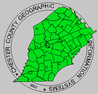
Chester County Location Map
GIS Initiatives
In 1988, the County retained the services of an outside GIS consultant to assess the implementation of geographic information system (GIS) in the County. The needs assessment report consisted of an overall review of the departments and their needs for interdependencies. It identified the core departments that would benefit from implementing a GIS. That report was accepted but put aside. In late 1992, Chester County requested that the consultant update the needs assessment report to generate a Master Plan and prepare a cost estimates for the acquisition and implementation of a GIS to be reviewed and adopted by the County Commissioners. During the same time the Emergency Services (ES) department was upgrading its installation with computer-aided dispatching (CAD) and an E911 system. To support the CAD system they were in need of GIS data consisting of road centerlines with accurate street names, address ranges and addresses. ES pursued a separate vendor and contract for the Addressing Project, but coordinated with the Master Plan efforts.
Concepts and Strategies
The Master plan "for a land records system for Chester County" included a concept and the components of a proposed GIS system, and the tasks and schedule for implementation of the system. The master plan was based on the review of then current land records operations and an evaluation of requirements for land records. The concept addressed the requirements for the hardware/software configuration and database to support the necessary information and its management for the GIS. The concept was based on a central database management system and sharing of data and other system resources among county departments. The GIS was the key part of this concept to provide needed mapping and geographic analysis capabilities. A series of applications to support or perform various functions of participating departments were identified. The overall concept for implementation of GIS included a central database management system, continuous updating and maintenance of data, to provide necessary up-to-date data to all system users and applications. The project management and implementation strategies are covered in a later section of this paper.
Modernizing land records was defined as integrating the Recorder of Deeds processes and data with those of the Assessment Office. By the adoption of the Pennsylvania Uniform Parcel Identifier (UPI) Law, business process reengineering and computer automation, the County could streamline workflows, eliminate redundancies, store and retrieve data more efficiently, and provide better service to the public. Under the UPI Law, all recorded documents affecting the future transfer of land must have an UPI on them, and the UPI would be the legal equivalent of a legal description. Access to all records relating to any particular parcel can be made by the UPI assigned to that parcel, as well as the traditional keys of owner name or street address.
The Land Records System (LRS) is one of several enterprise-wide automation projects the County has undertaken in the past decade. The migration of many legacy applications running on a Unisys mainframe to a client/server architecture spawned many enterprise-wide infrastructure improvements and exponential growth of the network. Such projects as a county-wide reassessment, the acquisition of the Integrated Assessment System (CAMA), the E-911 system, the Courts system and the PeopleSoft Enterprise 2000 have been undertaken in an attempt to position Chester County as a leader in government services in the 21st century. While the vision and scope of these projects are extraordinary, the challenges in completely realizing the benefits of these efforts are sometimes daunting. A modern Land Records System yields many benefits not only to Chester County, but to the municipalities, real estate and title professions, and the general public as well. Having a centralized database and appropriate automation to support county operations will revolutionize the way Chester County government does business.
Conceived in 1993, the initial LRS was designed, implemented and tested between 1994 and 1997. Two committees were formed to oversee the project: the Technical Committee and the Policy Committee. Working with these committees, the Department of Computing and Information Services (DCIS) and consultants undertook the responsibility of reengineering the Land Records process. This endeavor was composed of several significant tasks:
- Establish the Business Rules, Procedures and Data Model
- Develop Institutional Restructuring and Process Reengineering
- Application Development – Providing the Tools for Implementation
These tasks were attempted over a period of seven years and purported to lay the foundation for a LRS. As projected, the LRS project succeeded in:
- Establishing a high-level systems architecture and a GIS Organizational Structure.
- Establishing a Registry Organization, the Bureau of Land Records (BLR), as the central and permanent repository of all County Tax Maps, and as the designator of an UPI.
- Acquiring the necessary hardware and software systems needed to support a state-of-the-art GIS, including a modern LRS.
- Performing the digital Tax Map Conversion and acquiring a planimetric Land Base, both of which form the foundation for the County’s digital map database.
These accomplishments have provided a framework for all future GIS and land records activities.
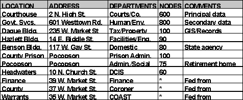
Chester County has a well-organized Banyan Network consisting file, e-mail and print queue services provided by a network of fifteen Banyan Vines servers distributed at the Courthouse (4), GSC (5), and one each at Headwaters, the Prison, the Pocopson Home, and the Dague, Hazlett and Benson Buildings. There are also several departmental NT domains at several locations as well as approximately 25 NT servers providing Web, application, database, CD-ROM and remote access services on the local area network. Several variants of UNIX servers are distributed across the network. In addition, there are also over 200 network printers supported by the local area network as well. In all, the Chester County network consists of 1800 nodes on 16 user networks and approximately 130 switches and hubs.
The county office locations are detailed in the Table 1. The principal departments and approximate total number of network nodes at each location is also included.
TABLE 1
The county has a variety of legacy information systems as well as systems in deployment and planning for providing county services. Much of this information has been moved from a Unisys A18-511 mainframe to a variety of two- and three-tier client-server systems. The principal countywide information systems are:
In addition, the county currently has a network of fifteen Banyan Vines servers that provide common file, print and e-mail services across county departments. Many departments also have systems on various platforms supporting their specific county operations.
History of GIS Implementation
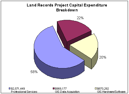
A brief history of GIS implementation by the County is presented in Table 2. The Table 2 lists major accomplishments and milestones by year. Figures 2 and 3 illustrate capital spending history and breakdown in the implementation of LRS during 1993-1999.
TABLE 2
|
Year |
Evolution of GIS at Chester County - Accomplishments |
|
1988 |
|
|
1992 |
|
|
1993 |
|
|
1994 |
|
|
1995 |
|
|
1996 |
|
|
1997 |
|
|
1998 |
|
|
1999 |
|
|
2000 |
|
FIGURE 2
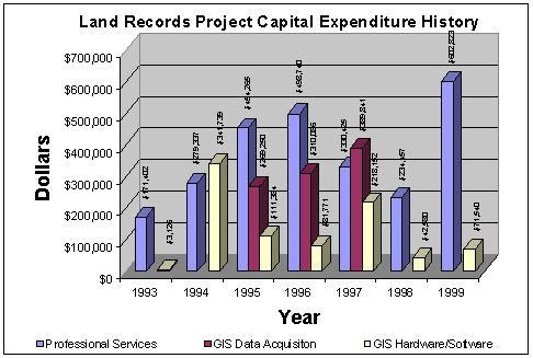
FIGURE 3
THE PROJECT MANAGEMENT APPROACH
The County’s Department of Computing Information Services (DCIS), was charged with the implementation of an enterprise-wide GIS, consisting of a land records system, a relational database management system, ArcInfo and ArcView software, in addition to imaging and electronic document management software. Departments actively participating in the implementation GIS are listed in Table 3.
TABLE 3
LIST OF PARTICIPATING DEPARTMENTS
|
Computing and Information Services/GIS |
Recorder of Deeds |
|
Assessment |
Voter Services (Elections) |
|
Planning Commission |
Engineering |
|
Treasurer |
District Attorney |
|
Emergency Services |
Detectives |
|
Health |
Sheriff |
|
Parks and Recreation |
Human Services |
|
Water Resources Authority |
Housing and Community Development |
Strategy and Organization
The basic strategy to manage and perform the implementation of GIS was to set up a land record project team, consisting of staff from DCIS and personnel from a consulting firm. In addition, two committees, a Policy and a Technical Committee were formed to assist in the implementation of the GIS. The team was supervised by the County's Land Record Area Manager and was responsible for the implementation of the GIS. The County initially did not have enough resources or people trained in GIS and, therefore relied on the consultants expertise in GIS field. There were on-site consultants, who were working full-time on the project to assist the county in the implementation effort. The lack of GIS implementation experience put the county staff at disadvantage. They had to rely on the consultants expertise. While the LRS project has benefited from a team approach and the involvement of multiple departments, consultants and committees, it has also suffered traditional disadvantages, such as departmental inflexibility, lack of coordination, staff burnout and slow response to change.
Policy Committee consists of executive level persons. Its role is to assist in establishing policies and priorities, to guide system development and its evolution, and assist in budget co-ordination. Membership for this Committee is drawn from key user departments (initially DCIS, Planning, Assessor, Recorder, Health and Emergency Services). Representatives of individual departments shall identify key GIS personnel within their department, define how to employ GIS technology, participate in and review conceptual database design, provide guidance in the development of internal procedures and data access policies.
Technical Committee consists of technical level persons. This group addresses technical issues and provides guidance to Land Records System core staff and users. Its role is to identify policy issues for Policy Committee consideration. Membership for this Committee is drawn from user departments (initially DCIS, Planning, Assessor, Recorder, Health and Emergency Services). Members shall, within their respective departments, be very familiar with the internal processes, be able to identify needs, users, training and design applications. They should also be intimate with the implemented technology so they can provide recommendations/requests for system enhancements, extensions or procurement of supplies.
This is the initial Land Records System (now the GIS Technical Services group) core group. It provides system management, database administration and day to day support to system users. Its responsibility is to manage all hardware and software components, perform on daily basis data and software backups, resolve problems, liaison with vendors, administer maintenance contracts, install upgrades, monitor system resource utilization, plan and acquire replacement/upgrade/enhancements, authorize system access and allocate system resources.
On the database side this group provides central administration of the LRS database, authorize database access privileges, maintain database directories, maintain and upgrade database design, ensure database integrity and implement quality assurance procedures.
On the development side this group designs, develops and maintains application programs, determine user requirements, provide consultation services for users and document user applications.
This group also identifies technical issues that are reviewed by the Technical Committee for guidance.
Over time the role of the DCIS Land Records Team has changed and responsibilities have been assigned to two groups. A GIS/BLR group is responsible for maintenance of parcel database and some application development. A GIS Technical Services Group is responsible for much of the hardware and software management activities.
It is essential that all GIS resources be managed carefully and continuously. Because of the number of departments and agencies involved, specific plans for managing, maintaining, and distributing data should be developed. Currently the GIS implementation is managed by two groups, as mentioned above. The GIS Technical Services Group, who manages and administers the GIS hardware and software and database. This Group has responsibility for providing GIS and Information Systems support to County staff. The County potentially has more than 100 users of the GIS. The GIS/BLR who develop and maintain GIS data, both graphic layers and nongraphic databases, establishes data development priorities, and oversee contractor effort for database and application development. This Group has responsibility for maintaining one of the most important GIS resources, the parcel base. The GIS Technical Services Group must ensure that it is published and accessible to its large user base.
The GIS serves all County departments. As more and more GIS users can be served and brought on line, the benefits of full GIS implementation will begin to be realized. The GIS data resources are also extremely valuable assets of the County. These vital and dynamic resources must be carefully maintained in order to retain their value. Projects such as IAS (Integrated Assessment System) upgrade, which are underway will result in significant integration of data resources as well as updates of operating environments.
GIS Organization and Staffing
The GIS is managed and administered as an IT system under the direction of the County Chief Information Officer (CIO). As a unique system, however a specific core GIS Group was created within the DCIS structure. Significant GIS activity does occur at the department level. Departments who have developed GIS resources and expertise can rely on the DCIS for support and coordination. DCIS provides technical support and assists with the gradual improvement and centralization of enterprise-wide resources such as the fundamental GIS layers. Individual departments may still develop mission specific GIS resources and applications.
The current GIS organization provides service to all County departments. Individual departments also have internal resources. Some departments have "power users" who have expertise in basic GIS software and are capable of application development and sophisticated use of the GIS. Other departments are completely dependent on the services of the GIS organization within DCIS.
GIS Components
The primary GIS software selected by the County are Arc/Info and ArcView developed by Esri. Arc/Info provides tools to manage numerous data types, including vector, alphanumeric and raster data. It has allowed the construction of a County-wide distributed multi-purpose geo-referenced database. A key component of the GIS is the ability to link geographic data with other database located in external databases, like Oracle. The GIS software is used to manage, process, map and analyze all geographic information. It is also used to maintain standard maps with the addition of updates as new development takes place and other changes occur in the county. Cadastral mapping takes place as new deeds and subdivisions are recorded, utilizing Arc/Info and COGO. ArcStorm is used to house the cadastral and planimetric base maps while Librarian stores other coverages.
GIS Database
The digital base map consists of topologically structured digital data sets in Arc/Info native format that store points, lines, and polygons using the Pennsylvania State Plane Coordinate System, South Zone NAD 1983 and that have attribute data and/or annotation associated with each graphic feature. The legacy system of 1" = 100' mapping in urban areas and 1" = 400' mapping in rural areas has been standardized on 1" = 200' mapping county-wide in 5000’ x 5000’ grid. Plotted tax maps distributed to the 73 municipalities remain at 1"=400’ and 1"=100’.
The County obtained the following features along with the digital orthophoto data:
- DEM (breaklines and masspoints)
- Public Roads (edge of pavement)
- Driveways in excess of 200'
- Road centerlines
- Building centroids
- Major building outlines
- Hydrography
- Railroads
- Obscured areas
- Parks
- Airports
In 1995 the County began a digital tax map conversion project and hired a consultant to manage the project. The original hand-drafted linen maps were scanned into digital files and rectified to the orthophoto base. Property lines were adjusted to the planimetric right-of-ways. Buildings and natural features were used to correct questionable areas. The project was completed in 1997 and the coverages were delivered to the County. Subsequent cleanup edits have been and will continue to be on-going.
Relational Database
The relational database management system (RDBMS) used is Oracle, developed by Oracle Corporation. It is used to store and manage all key land record data. Oracle links all types of information stored in GIS. The primary index used to link the types of data is the Uniform Parcel Identifier, or UPI.
Hardware
GIS and Oracle services run on a mix of UNIX and NT platforms on an Ethernet network using TCP/IP. Original equipment purchased in 1994 were IBM RS6000 250 workstations, running AIX UNIX. The production Cadastral Mapping function and GIS data are on UNIX and are maintained in ArcInfo 7.2.1 and ArcStorm. The current production Land Record Maintenance function utilizes an Oracle 8.15 database on UNIX and an Oracle Web Server front end on NT, accessed by desktop Internet browsers. Development and testing take place on a mix of UNIX and NT servers.
An IBM RS6000 J50 server running ArcInfo and Oracle was also acquired in 1994. Through upgrades over 4 years the server has 6-200Mhz processors, 2Gb RAM and 80Gb storage. The local area network solution was 10BaseT Ethernet and utilized NFS and Xwindows based client/server model. As a result of recent upgrades the network has segments of its backbone running Gigabit Ethernet over fiber, and Fast (100Mb/s) Ethernet over CAT5 UTP everywhere else. Cisco Routers have replaced 3Com. An IBM RS6000 Model 250 is the server located at the Government Services Center (GSC) location, redundantly storing GIS data in a distributed environment due to remote network limitations.
Recently 2 new IBM RS6000 H70 servers have been acquired with 2-340Mhz processors, 2Gb RAM and 88Gb storage each. One serves as a production Oracle database server (dedicating the older J50 to ArcInfo/GIS data) and the second serves as a development/test server. Six Compaq NT servers are also used as Oracle Web application, development, and ArcView distributed data servers.
THE IMPLEMENTATION STRATEGY
The basic strategy of the Master Plan was to build a land record infrastructure centered on the parcel and its unique identifier. The first application development and maintenance operations focused on maintaining parcel data that is being shared by many agencies. The LRS functions as a source for tracking parcel history, including chain-of-title and parent-child relationships.
Implementation Phases
The 1992 Master Plan suggested 3 phases, involving 45 tasks spread out over 4 years. The first phase would be the construction of a tabular parcel database using an RDBMS. Hardware and software acquisition and a parcel data load were the next tasks. The second phase would occur when parcel data maintenance operations were in process. This phase would include the acquisition of GIS components and creation of the Registry (BLR). The next task would be to link the RDBMS and the GIS. The third phase proposed additional application development involving both the GIS and RDBMS.
The tasks proposed were implemented in a different order during implementation, due to several reasons. Essentially hardware, software, planimetric landbase and tax parcel coverages were purchased first. During this time the design and initial development of the LRS took place. In 1997 data loading was started along with testing of the system. The BLR was created and an UPI Pilot project got underway in 1998. The testing and pilot project revealed many weaknesses in the design, performance and data of the system. In 1999 a design review was performed, the results of which proposed the termination of the pilot project and a redesign of the system.
Throughout the later half of 1999 and the first half of 2000 the system underwent many substantial modifications. It is currently in user acceptance testing phase, and a pilot phase is scheduled in July and a go-live date in September.
Lessons Learned (Do’s and Don’ts)
The successful implementation of GIS requires good project management principles to successfully meet all the challenges during this process. A project of this size requires a well thought out implementation strategies with sufficient control to monitor any changes and to address any problems encountered during the implementation stage. Following are some of the problems that were encountered during the implementation of GIS at Chester County.
Project Leadership - A successful GIS implementation requires a "Project Leader", who has the necessary management and organizations skills to get the job done, and to motivate people and get them excited about their work. It takes a focused leader and cooperation to overcome traditional organizational inertia and hurdles.
Project
Success Visibility – For a GIS project to get management and users support, it should produce deliverables and products over short time frames to allow quick results that can be seen and used. The length of the project has prevented the County, the staff and management from seeing the intended benefits of the project in a timely manner. Frequent visibility of success stories to upper management and to users is critical to keeping momentum and funding for new initiatives.
CASE Tools – Use computer-aided software engineering tools for the design, analysis and building of applications and databases. Use business process and data model diagramming tools. Many hours of development will be saved by use of a tool such as Oracle Designer.
Outsourcing Issues – Carefully review needs assessment reports and master plans. Make sure the content of each is addressing your needs. Establish criteria before hand on what your organization wants from an assessment report. Often a consultant will reuse documents prepared for other clients, with 60% of its content being off-the-shelf, boilerplate, this-is-what-GIS-does material. Hiring consultants requires a full time staff to manage and monitor. Consultants generally don’t take ownership of a system or pride in searching out issues and imperfections that aren’t in their scope. Consultants generally sell you the idea of their expertise, and then insert less experienced personnel to learn on your project, at your expense. Make sure the GIS consulting firm you hire has real world IT and database experience, and has a successful track record in implementing systems. Forty percent (40%) of all IT and 60% of GIS projects never reach fruition because of cost, schedule overruns or poor performance upon delivery.
Prototype software – Make sure the final system delivered isn’t the prototype with some window dressing added. At some point during development the prototype must be scrapped and the final version built with all the lessons learned. If the comment "We’ll fix this in the next release" is made too often, it might be time to scrap the current version or the developers responsible.
CURRENT AND FUTURE DIRECTIONS
In 1999 a concentrated effort took place to reevaluate the status and course of the GIS program. A design review of the LRS was performed, and the conclusions reached were the basis for the modifications to the database structure and the application functionality. Besides data model, integration and function changes, the client/server technology moved from 2 tier UNIX-based Oracle forms to 3 tier NT-based Web forms and an Oracle database on UNIX. The web-based forms server eliminated the need to visit every desktop for software installs and increased performance considerably. It also reduced software and maintenance costs and provided greater availability to more users. The need for an updated strategic plan was identified, but would not be addressed until the mid-2000. A considerable portion of resource time was consumed during the last half of 1999 performing Y2K remediation work and testing, budget planning and departmental restructuring.
The original Master Plan identified 25 functions from various departments requiring integrated land record support. Nine of the twenty-five have been completed (more or less as envisioned) as part of the implementation to date. Finished are Assessment Information Maintenance, Assessor Map Maintenance, Standard Map Maintenance & Specialty Map Maintenance, Property Appraisal, Tax Billing, Parcel Recordation, Public Information Retrieval, Emergency Dispatch and Stream Quality Monitoring. In various stages of development or not yet started are: Plan Review, Plan Analysis, Transportation Analysis, Standard Information Repository, Tax Claim, Appeals Process, Parks Facility Management, Emergency Planning and Management, Crime Analysis, Well/Sewage Permit Processing, Public Health Laboratory, Gypsy Moth Suppression, Election Geocode Assignment, Epidemiology Analysis, Cultural Resource Inventory, and Engineering Analysis.
Several strategic sessions with key departments were held to identify the status of GIS within each department, current needs, and to set out priorities for the next 1-2 years. In the fall of 1999 a dozen departments convened to address technology, data, staffing and training requirements. Several matrices charting data class/attributes, projects and staffing support levels needed were generated. A laundry list of projects costing an estimated 5 million dollars over 5 years was assembled and prioritized. The list included projects for acquiring more base map coverages, continued enhancements to the cadastral, geofile (E911) coverages, data cleanup tasks, departmental applications and data sets, training program and technology infrastructure improvements. A cost benefit analysis justifying the priorities set is planned as part of the Strategic Plan update.
Although the Commissioners gave conceptual approval to the funding request, no monies have been made available for the longer-range projects. Approval for funding should be obtained in June for short-range capital projects over the next year in the amount of approximately one million dollars.
Current Activities
The focus during early 2000 has been the final implementation of the Bureau of Land Records and the PA Uniform Parcel Identifier Law, and the ChescoView application. The Bureau of Land Records application (formerly "LRS") will loosely integrate the Recorder of Deeds system with the cadastral maintenance, UPI assignment and land records functions of the BLR. It serves as a front end to the Assessment Office’s CAMA system, IAS. It has eliminated half of the redundant data entry and record handling activities within the Dague building, which houses the Recorder, Assessment and the BLR.
The remaining tasks in the BLR Project Plan have been divided into 6 sub-projects. They are Project Management, Business Procedure Development, Land Records Operations, Application Development, System Infrastructure, and Documentation. Each sub project has been further divided into smaller projects and tasks, each with time frames, staff assignments, percent completes and interdependencies linked. The project schedule is maintained on a weekly basis and is used as a tool to monitor progress and identify the impacts of delays.
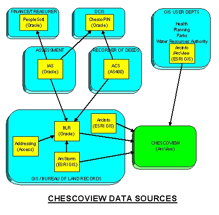
The ChescoView application serves as common ArcView interface for querying, navigating, selecting, viewing and plotting standard County GIS data. It is aimed at removing some of the software complexity for end users and providing a common standard interface and theme set to all the departments. It was initially designed on ArcView 3.0a and the original LRS model. Originally scheduled for rollout in 1997, it had to wait for the County to upgrade its desktops from Windows 3.11 to 95 to take advantage of 3.0a. By that time the database design it was based on had changed substantially. This required modifications along with some other improvements. It is now scheduled for release by the end of summer. Reference Figures 4 and 5 at the end of this section for high-level data diagrams.
Other recent activities for participating GIS departments included an initiative to provide color printing/plotting output capability scaled to group requirements, and an expanded training program for new and existing users. The Health department received a grant for technology to assist in tracking dead bird reporting and instances of the West Nile Virus. The District Attorney’s office also received a grant for a crime tracking and analysis project. The Planning Commission has developed several in-house applications including a Data Catalog extension that allows menu driven theme selection and metadata access. Also started is an Intranet GIS web site. Chester County is participating in an informal tri-county consortium with Lancaster and Lebanon Counties. Inventory, standards, goals and issues are shared at quarterly meetings.
FIGURE 4
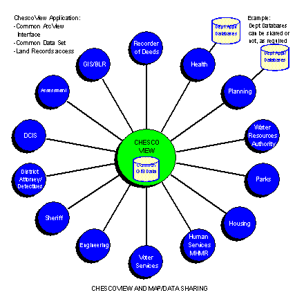
FIGURE 5
Chester County GIS is entering an intermediate stage where the initial components are maturing and growing. Each department is developing the ability to perform advanced analysis, and not just view maps and data. The next stage in GIS implementation at Chester County includes expanding and maturing the GIS data sets, creating a GIS data warehouse and web based applications for use by County departments, municipalities and the public. Continued development of customized departmental applications, data distribution tools and collaborative web tools with the municipalities are also envisioned. Updating the GIS Strategic Plan is one of the main priorities for the remainder of this year, as it has not been revisited since 1992. The shift in focus for the next year will be more on "traditional" GIS activities and less on solely modernizing land record business functions.
The expansion of the existing GIS layers includes acquiring updated digital orthophotos, planimetric features such as topography, building outlines, geodetic control, incorporating 2000 Census data and others. ADR was hired to perform the aerial photography and data production for the Delaware Valley Regional Planning Commission’s Transportation Planning project. As one of the member counties, Chester County will receive new 1"=200 scale digital orthophotos at 1.5 pixel resolution, and be able to purchase related data products. One of the products will be 10’ contours.
The spatial data warehouse will house data from the Assessment Office, Recorder of Deeds, Bureau of Land Records, Tax Claim, District Attorney, Detectives, Planning Commission, Health, Parks, Voter Services and others. It will run on an IBM RS6000 AIX platform with an Oracle 8I database and an NT web based front end consisting of Internet Map Server and Oracle Web Server technology. Initially it will be accessed by County departments, and later access by municipalities and the public will be phased in. The collaborative tools with the municipalities will allow the townships to interactively update street names, street addresses, building permits into the County database. ChescoView will be converted to a web-based application as part of this process. Continued integration of key land record functions; Planning, Health, Recorder’s, Assessment, and Bureau of Land Records is a central goal of this project as well.
Behind the scenes of the plans for further application and database development is a drive to develop and maintain a sound technology architecture. The County is evolving from a 2 tier client/server environment to a web-based 3 tier architecture. The debate over UNIX vs. NT at the County has been resolved by running both in a mixed environment. Experience has proven that neither replaces the other, that large Oracle databases with high transactional volume need UNIX as the database platform, and that middle tier applications integrate best in a Windows environment. The County is currently migrating its Banyan network to an NT network during the next year, and is also replacing all of its standard Windows 95 desktop PCs with NT 4.0 Workstation over the next 3 years. Later this year the GIS will investigate the benefits, requirements and costs of migrating to ArcInfo 8, ArcSDE, Oracle 8I Spatial, and ArcIMS. Currently informal testing of ArcInfo 8 is underway.
CONCLUSION
No matter the complexity or degree of GIS Implementation at an organization, planning, coordinating and managing change at both the high and detail levels throughout the course of the project are critical to its success. Implementing enterprise-wide GIS does not mean doing everything at once. Plan large, multi-participant, multi-year, multiple component projects in well-defined modules that have a visible, tangible deliverable in a short amount of time. Waiting years to show the results of the project to upper management can result in delays in funding for future projects and a loss of confidence in the validity of the project. Remember that people make or break the success of GIS, not the technology. Plan carefully, then monitor, update and adapt the plan. Close the loop on quality control and communication.
Enterprise-wide GIS requires a number of things to be planned and obtained. A sound technology architecture with a well-designed environment, adequate network connectivity and reliability, documented maintenance, backup and recovery procedures, and an appropriate number of trained staff is only one component. Well-defined business functions, procedures, rules and data models are critical in the design of applications and how they perform during daily operations. Communicating with and understanding end user needs and expectations is important to the success of the plan.
Whether designing a system or an implementation plan, it is important to consider the following guidelines:A common mistake made is to assume that the mere purchase of technology automatically equates with realizing the promised benefits, and allows a reduced staff head count. Invest wisely in all the components of GIS, the hardware, software, people, data and methods. Develop staff training, career path planning and on-the-job experience programs aimed at increasing staff retention and skill levels. The methods of doing daily tasks and utilizing new technology must be adapted to each other. Business processes must change to take advantage of features and capabilities of new systems. Don’t underestimate the impact of departmental cultures and people’s attitudes on how many of a new system’s benefits are actually realized.
The GIS Program at Chester County has accomplished many of its goals and has benefited from good planning, project management, innovative designs and a great deal of hard work. It has experienced many trials and tribulations, successes and failures over the past seven years, but is going strong. The staff and management have closely examined the past and present course of the project and are enthusiastic about showcasing further success stories in the near future. We look forward to hopefully sharing our experiences in the growth and development of the County’s GIS in the years to come.
Paul R. Dioguardo Mohammad Tariq
GIS Technical Services Manager GIS Project Leader
pdioguardo@chesco.org mtariq@chesco.org
County of Chester
Department of Computing and Information Services
10 N Church Street, Suite 200, PO Box 2748
West Chester, PA 19380-0991
(610) 344-6475, (610) 344-6794 Fax
REFERENCES
Chester County. "Chester County Land Records System Master Plan Update."
PlanGraphics, Inc.: 1992.
Chester County. "CHESCO-LRS Re-engineered Land Records Logical Design."
Chester County DCIS/PlanGraphics, Inc.: 1996.
Havan-Orumieh, Marina, et al. "Overview of the Reengineering of Land Records Process in Chester County, Pennsylvania." 1997.
Chester County. "Land Record System, Project Review and Recommendations"
Dioguardo, Paul R., Brinton, Patricia, Chester County GIS, DCIS staff: 1999