This paper will describe the different phases involved in the purchase of digital orthorectified images. The entire scope of the paper will be from the process of performing a quality-check to the experiences and lessons learned while dealing with the vendor and county departments. The usage of Esri tools will be discussed. Furthermore, technical specifications, guidelines and resources will also be discussed such as: quality standards, distribution of the data, hardware/software used and technical personnel employed. For the conclusion, examples will be given of applications that will benefit significantly in a government setting from these digital orthorectified images.
Miami-Dade County was formed in 1957. The county is comprised of a large unincorporated area and 30 incorporated areas or municipalities. The total population for the 30 municipalities is approximately one million. Among its cities are the well known city of Miami (the largest one), Hialeah and Miami Beach. The areas of the county that do not fall within the cities comprise the unincorporated area with a population of approximately 1.2 million. With the growth in population in Miami-Dade County there has also been a tremendous growth in the types and levels of services provided by its government. The project we are presenting today is part of an overall strategy to provide GIS improvements over the present system and ultimately bring more efficient and effective services to the citizens of Miami-Dade County.
Miami-Dade County started working in the implementation of a GIS since 1986. The implementation was coordinated by the Information Technology Department and funded from several departments. Environmental Systems Research Institute's (Esri) Arc/INFOź software on a VAX/VMS(tm) platform was selected and installed. The Miami-Dade County street network was the first base map layer upon which many other layers were developed. In 1991, a joint project was undertaken with Florida, Power & Light to develop a parcel base map. The layers developed under this project provided an essential level of detail for many County departments. The first set of planimetric layers were developed in 1991 as part of this project. The parcel base map was completed in 1993. Currently, there are about 500,000 properties in the Parcel Layer and about 100,000 street segments in the Street Network. During the end of FY 1999/2000, Digital Orthophotography for 926 square miles was added (the topic of this paper) as another layer to the GIS. The amount of GIS data and number of users continues to grow along with the recognition of the power and value of the technology.
The current GIS infrastructure supports two DEC 8200 Alpha Processors, running Tru64 UNIX (Compaq(tm)) operating system environments (production and development) along with GIS software products from the Esri product line. The infrastructure also supports Windows NT(tm) servers for use by client/ server and Internet applications.
This project was managed by the Information Technology Department since the beginning. As part of the feasibility study phase, the County developed a survey to collect information from the different departments to assess needs and requirements for aerial photographs and planimetric layers. The consensus was to acquire digital orthorectified photographs with updates for the existing planimetric layers.
Further details of the survey were as follows:
County Departments that are major users of GIS funded the project. The legal contract specified the acquisition and maintenance of a new GIS layer of "computer rectified" aerial photographs for 926 square miles of Miami-Dade County over a four-year period. The final products for the first (1999) and third (2001) years of the legal contract consist of digital orthophotography with updates of the existing planimetric layers. The second (2000) and fourth (2002) years of the legal contract provide the County with the option of acquiring aerial photography in hardcopy or digital format. The method used to select a vendor fell under the category of Request for Professional Services under Florida Statutes and under the Miami-Dade County Code. The vendor selected was Woolpert, LLP.
The photographic coverage for the project was divided into four geographical areas (see figure 1). Each completed area constituted a milestone in the project. The project schedule was carefully planned between the vendor and Miami-Dade County. The project was organized in five phases. The main phases consisted of one Pilot Project Phase and four delivery phases, each one covering a geographic area. During the Pilot Project Phase, the initial fine-tuning for the specifications were made. Miami-Dade County provided the vendor's staff with some collection criteria for the planimetrics and the photographs. The initial schedule for the first set of photography received was to have flight schedules only until March 1999. Due to weather conditions, most flights were made towards the end of this period. As a result, the vendor and Miami-Dade had a reduced timeframe for delivering and checking the data. The first set of photography was checked between April 1999 and October 1999. The remaining phases followed strict scheduled timeframes which imposed great demands based on the limited resources available for the project. The rest of this paper will focus on the Quality Checking Process as the photography was received during the first year of the project.
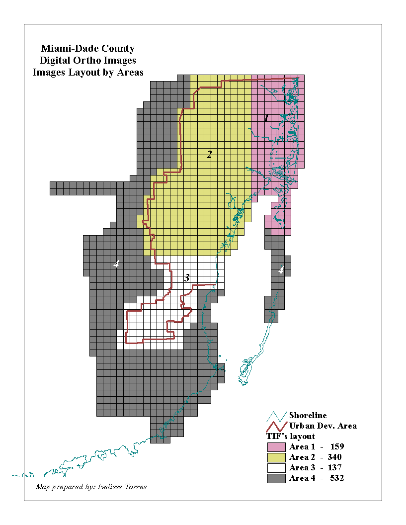
Figure 1.
The specifications for the digital ortho images were, 1 foot per pixel resolution with ± 2-foot horizontal accuracy within the Urban Development Area and ± 5-feet horizontal accuracy outside of the Urban Development Area. The coordinate system was State Plane, Florida East, NAD83 and the file format was TIFF.
For the planimetrics, the basic requirement was that compatibility be maintained with the existing ones. The planimetric layers met National Map Accuracy standards for 1"-200' scale mapping (positional horizontal accuracy of +/-5 feet). The specifications for these layers were as follows:
Edges of street/road pavement were defined as the outlines of publicly traveled streets or roads. The line digitized for the edge of a paved street was the actual edges of pavement, including any paved shoulder.
Large buildings were defined as built structures that did not appear on aerial photographs to be a detached single family residence (SFR). Structures of large size exceeding eight thousand (8,000) square feet or in an apparently commercial, industrial, or other non-SFR area were digitized as large buildings. All large miscellaneous structures such as storage tanks, water towers, and stadiums were also digitized as large buildings. Sheds, small barns, and other small indistinguishable structures were not captured.
Railways were defined as active railroads. The apparent centerline of the tracks were digitized as they appeared on the aerial photographs. Abandoned railroads and railroad beds were not captured. Abandoned railroads were defined as those with portions visibly overgrown by vegetation, paved over, or having the general appearance of being unused. Railroad beds were defined as formerly active railroads for which the rails had been removed.
Water bodies were defined as shorelines, rivers, lakes, creeks and streams with visible flowing water as they appeared on the aerial photographs. Small agricultural ponds with a size less than 0.5-acre were not captured.
The product consisted of the following deliverables:
|
Planimetric Layers |
||
| Edges of Street/Road
Pavement (updated) |
Arcs |
Edges of roads, bridges. |
|
Large Buildings (updated) |
Polygons |
Tall buildings, storage tanks,
water towers, stadiums, commercial buildings. |
|
Water Bodies (new) |
Arcs and Polygons |
Shorelines, rivers, lakes, creeks
and streams |
One of the biggest challenges for this project was to maintain the project on schedule with the shortage of personnel resources. The shortage of staff did not imply a reduction or change from the original goals that were set forth for preserving the quality of the product. The following staff was utilized for this project:
The QC/QA process included general tasks and tasks performed at the initial phase of the project (such as checking the flight lines before the flights started, and checking the contact prints before the final production of the photography). Once all general tasks were performed, the remainder of the tasks were dedicated to the QC/QA of the photography and the planimetric layers.
For the photographic images, the quality-checking process included the analysis of 100% of the product during the delivery phase. For the planimetric layers, the quality-checking process included the analysis of 15% of the product during the delivery phase. Subsequent to the delivery phase, a currently on-going quality checking process involves the analysis of 100% of the product with the QC tools that have been developed in-house with a series of AML programs.
After completion of the Pilot Project Phase, we created a document template in Wordź format with a complete checklist of the different quality-checking steps performed for each area. After finishing each area, the document was loaded with the results collected. This document contained the analysis done for each area. After completing the QC/QA for an area, a meeting was always scheduled with the vendor. Issues that were discussed mainly focused around technical details, approval for the area completed, and preparation for the delivery of the subsequent area.
For the quality checking/quality assurance phase of the images, a set of Avenueź scripts, image catalogs and ArcViewź projects were created. The Avenueź scripts were used along with the special ArcViewź shapefile shown in figure 1. This shapefile corresponded with the layout distribution of the images for the entire project. One important field (attribute) in this shapefile was the image name.
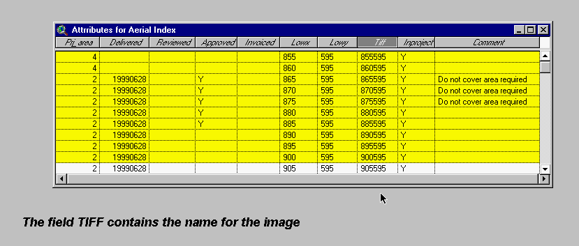
Figure 2.
The next discussion will concentrate on all the detailed tasks involved in the Quality Checking Process.
In this phase, we checked the map depicting all flight lines and compared them with the required aerial coverage.
This task corresponded with tallying the number contact prints reported by the vendor, as well as checking the proper labeling of the negatives, cloud shadows, sequencing, etc. The guidelines to perform this quality checking phase were provided by the consultant.
The aforementioned steps corresponded with the initial steps of the project, before the Pilot Project Phase. The following steps corresponded with the essential tasks required for each delivery area.
This step was the first task when receiving a delivery. The number of images to be delivered for each area was known well in advance. The images' layout (figure 1) divided the project by geographic areas. Each area consisted of a pre-determined number of images. The total number of images was calculated by using different methods. One method was to derive a simple directory listing using the UNIX(tm) command (ls -l) for the *.tif files. The final accurate count was derived using the ArcViewź project that loaded all the images.
To perform this task, the guidelines were as follows:
For this specific task, the following products were created:
For every area, we selected a sample set of approximately 30 PI points. The points were selected in areas where the urban density was high. The quality checking criteria was based on horizontal accuracy specifications of +/- 2 feet.
For the information collected, we detected some inaccuracies near the elevated passes where the deviation was greater than 2 feet. When errors were detected, we selected more points along the elevated passes. The vendor verified and improved the image creation process for these inaccurate images and they redelivered them to us without compromising the quality. The detection of the X,Y inaccuracies near the elevated passes led us to detect another type of error in the images (see image distortion).
Special considerations in image processing for downtown Miami, Miami Beach, and Aventura was required as a result of the very tall buildings prevalent in these areas. When viewing the aerial photographs, tall buildings appeared to "lean" away from the center of the photograph- technically this is known as "relief displacement." From a visual standpoint, it seems unusual and causes a large amount of ground-level detail to be obscured by the "leaning" buildings. To counter this effect, additional "spot shot" (1"=800' scale) photography was acquired by the vendor throughout these areas. Increasing the overlap along flight lines was not the solution for these areas. Instead "spot shot" photography taken between the flight lines was required. By retaking smaller and specifically localized blocks of aerial photographs for these "problem" areas, the vendor developed orthophotos that minimized the effects of leaning buildings and improved ground-level detail.
For the Pilot area, we selected an area where the tallest buildings were located. This was done to preclude the different types of problems we could encounter later. The pilot area encompassed two square mile sections (township, range and sections 54-41-01 and 54-41-12), located in downtown Miami. Six images of 5000 by 5000 feet were delivered for the Pilot area. From the first set of photography delivered for this area, we detected that some buildings did not comply with the technical specifications for large buildings where: "tall buildings should not cover edges of pavement".
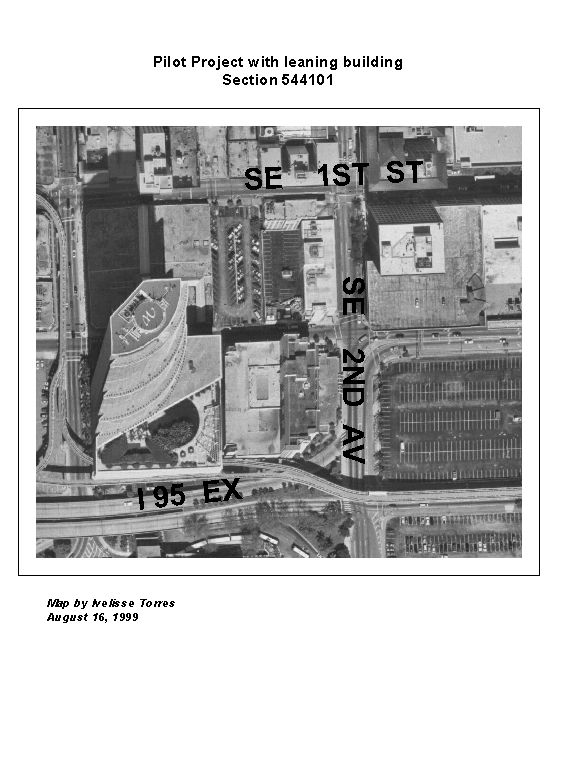
Figure 3.
With a careful visual analysis (see above), it is apparent that the buildings are covering the roads. An acceptable photo would be one where the buildings do not cover the roads. The vendor took spot shots (as described before) in the areas near the tallest buildings and the final results are in the following figure.
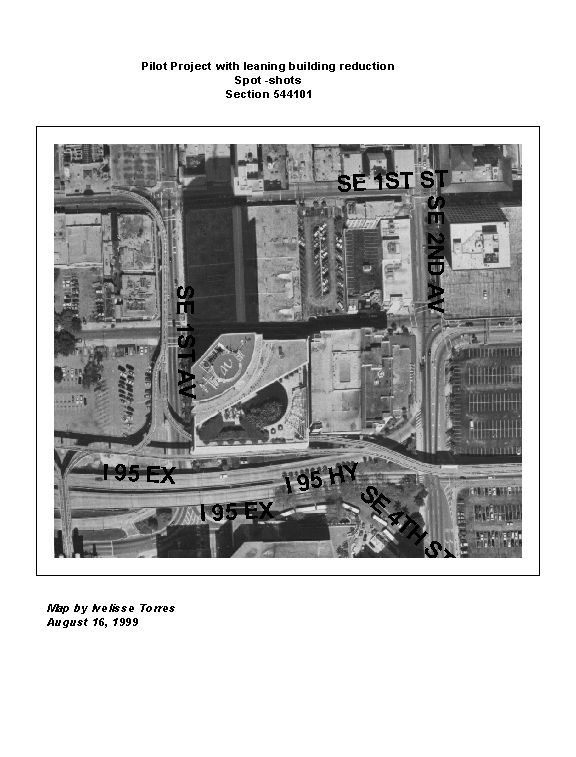
Figure 4.
In this photo (see above), the relief displacement was corrected and the user can see the roads around the buildings.
When checking for the X,Y accuracies and inaccuracies of the selected photo identifiable points (PI points), the areas near the elevated passes were found to have image distortions. For these areas, the vendor created true digital ortho imagery using an 'averaging' method which employs digital elevation models (DEM). To keep bridges, cloverleaf intersections, overpasses, and elevated highway ramps from appearing "warped" on the final image, this method used an average for the DEM elevations to rectify the areas for these structures. The elevated structures would appear warped if the DEM points were all at ground level. The use of these digital terrain models was an additional step that was employed by the vendor to improve the quality of the final image.
Figure 5. The image is distorted.
Figure 6. The image was corrected.
The planimetric layers that were recreated and updated as part of this project: Large Buildings, Edges of pavement, Railroads and Water bodies are part of an existing multi-tile Library (using ArcInfoź Librarian) for Miami-Dade County. Each tile covers a square mile section and corresponds with the Township-Range and Section division used in the state. The State of Florida was originally surveyed based on the rectangular survey system, with the exception of Spanish land grants. The rectangular survey system is a grid of survey lines running east and west (township lines) and north and south (range lines). The initial delivery of each planimetric layer for the four subdivided areas was a contiguous ArcInfoź coverage. After approval of the four areas, the vendor delivered the final layer by tiles (or sections).
For the "first" QC/QA process where we provided feedback to the vendor for the vector data we always checked between 15% and 20% of the features received for all the planimetric layers except Railroads where 100% QC was done. Again, the selection of the features was made in the densest urban areas. For this limited sample, the requirements were such that acceptable approval tolerances for the QC/QA process would never be less than 95%.
Comments for each delivery were given to the vendor in an ArcViewź point shapefile containing labels corresponding to the type of feature and type of error/comment found. This special shapefile contained a sequential ID number and an attribute (field) called error with the following definitions:
(The attribute error codes were developed by designating the first three characters to represent a description of the type of layer, with the fourth character representing the type of error detected. See description below)
| Layer | Type of error |
| LBD = large buildings | M = missing |
| WTR = Water | E = Extra |
| EOP = Edges of Pavement | Q = Questionable |
| RLD = Railroad |
Example: Error = "LBDM," meant "missing building."
For the Planimetric layers we divided the QC/QA in two major tasks:
We are currently performing an in-house 100% complete "second" QC/QA . For this process, we developed two in-house AMLź programs for editing and performing quality checks of the Planimetrics.
This layer was recreated entirely and it replaced the existing one in the multi-tile Library.
This layer contains all water bodies in Miami-Dade County.
During the QC process for this layer, a series of technical exchanges transpired between the vendor and us. This polygon layer only contains contiguous features of water bodies. Exceptions of polygons with 'non-water' bodies are cases where an island is inside a water body. For this Water layer, we modified the PAT (Polygon Attribute Table) for all the possible values of the field Water-id:
For the QC of the vector data we used the same ArcViewź project that loaded the images. Whenever possible, we selected to check special areas near the shoreline. If an area did not have a shoreline the features were selected at random. The final result of the QC for this area was given to the vendor as a shapefile containing errors and comments.
When working with vector data it is extremely important to create a plan with achievable goals. In our case, the Water layer was replacing the existing layer, but it was necessary to preserve compatibility with the original one because many AMLź programs and applications used this layer. We wanted to have an improved product without necessitating programmers to change their source code. This layer was the most difficult one to deal with during this project since total replacement of a pre-existing layer implied that both layers had to be 100% compatible. A 97% accuracy was achieved in the first "limited" QC for this layer. Currently, we are performing the second phase of the QC/QA using the AMLź programs prepared in-house.
This layer was a brand new addition to our existing multi-tile Library. It contained all active railroads, as well as the metro-rail and metro-mover lines. This is a special layer whose features run primarily from north to south in Miami-Dade County.
The attribute definitions for this layer were checked using the AMLź that compared the Feature Attribute tables for every coverage against their template.
Again, for the QC/QA of the vector data we used the same ArcViewź project that loaded the images. The initial QC/QA for this layer was performed for all of the features with the final results given to the vendor in a shapefile containing errors and comments.
A 97% accuracy was achieved in the first "limited" QC for this layer. Since this layer was brand new, there were no compatibility issues. Currently, we are performing the second phase of the QC/QA using the AMLź programs prepared in-house.
The specifications for these layers were to update the existing layers using the delta (changes, additions, or deletions) from the original layer's date of creation to this project's update. We received two types of coverages for the layers: the ones with the deletions and the ones with the additions. In our case, we needed to process the existing layers to incorporate these changes before performing the QC/QA process. To accomplish this update, we used the AMLź program developed in-house.
The attribute definitions for this layer were checked using the AMLź program that compared the Feature Attribute tables for every coverage against their template. This layer contained an item in the AAT (Arc Attribute Table) that defined the type of road. The definition was given to the vendor in the original specifications. For the edges of pavement the LINE_TYPE values were as follows:
The QC process for these values was performed using the same methodology as the one used for the Water layer.
The attribute definitions for this layer were checked using the AMLź program that compared the Feature Attribute tables for every coverage against their template. This layer only contained the standard attributes.
For each area, groups of contiguous images in their corresponding areas were selected. The QC for these layers were done using an ArcViewź project prepared for this phase. The digital orthophotos images were always used in the background. The final results of the QC for an area were given to the vendor in a shapefile containing errors and comments.
The graphic QC/QA for this layer brought certain issues to the forefront where criteria was decided on whether to include or not include a feature. These issues were addressed in the Pilot phase and included the following criteria:
A 97% accuracy was achieved in the first "limited" QC for the Edges of Pavement and 95% accuracy for the Large Buildings. Currently, we are performing the QC for the second phase using the AMLź programs prepared in-house.
All products received met all our technical requirements. Several Miami-Dade County Departments are presently using the data in different formats and with different platforms. The improvements accomplished with the products in some of our existing applications are noticeable. Many new applications are using the products and many other new ones are envisioned.
At the present time, we are eager to receive the second set of photography for the year 2001 which will bring added benefits to many county departments since the ability to compare 'changes' by using change detection software will be a reality. For county departments that need to perform inspections for their operations, this would decrease the on-site visits of areas that are not readily accessible. The actual return of the project's investment is quantifiable and will increasingly be an asset to Miami-Dade County as more users become familiar with the data. The Information Technology Department's goal is to disseminate the information from a centralized point where duplication of services are avoided.
The immediate benefits and products received as a result of the acquisition of the digital ortho rectified images were quickly evident. The following list describes applications that were enhanced or developed to include the images:
This was the first time Miami-Dade County embarked on this type of project. To arrive at the final stages of this first four-year contract, a lot of planning, research and preparation occurred. With a project of this magnitude, there were many obstacles to surpass, nevertheless a lot of support was received from upper management. Now, the results and benefits for the county are quantifiable. We will repeat the entire process in the year 2001 and this time the experiences and lessons learned will be invaluable.