Recent advancements in high-resolution digital camera technology and Infrared sensors, coupled with developments in DGPS and aerial inertial measurement units, make it possible to accurately inspect and collect asset inventory data for utility corridors faster and more cost effectively than ever before.
Utilities need detailed information about the location and condition of their transmission corridor assets and right of ways to quickly and efficiently maintain and service them. To accomplish this, utilities need to regularly inspect and collect accurate data.
The integration of new technology (high-resolution digital photography, DGPS, improved IR sensors, and inertial navigation) allows utilities to collect vast amounts of accurate location and up-to-date attribute data for use in a utility's GIS.
Case studies involving the Electrical Power Research Institute (EPRI) and other utilities will be discussed. Demonstrations using ArcView for the integration of the data will also be shown.
Deregulation and competition has changed the electric power industry business environment and has resulted in the need to increase the reliability of all utility systems. As competition becomes fiercer, performance must improve.
Nowhere is the need for reliability more critical than in Transmission and Distribution Operations. A power line failure or interruption in service has always been serious, but customers' expectations have now increased. More competition and choice for each customer means that a reliable Transmission and Distribution system is not only critical, it is a distinct competitive advantage.
Utilities need detailed information about the location and condition of their transmission corridor assets and right of ways to quickly and efficiently maintain and service them. To accomplish this, utilities need to regularly inspect and collect accurate data of their facilities.
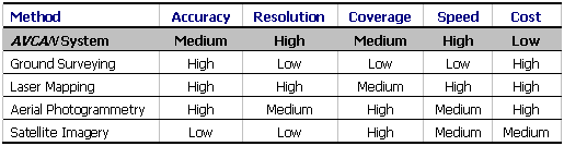
Traditionally, utilities have used a combination of approaches to perform asset inspections including ground, climbing, and aerial patrols. Utilities have also employed a combination of techniques to inventory assets including ground surveys and aerial photogrammetry.
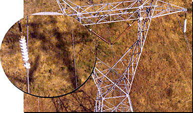
All of these techniques have inherent benefits and limitations. Ground inspection and inventory are very effective methods of collecting detailed asset location and condition data, but are expensive and very time consuming. Aerial inspection patrols are fast, but the detection/condition defect rate is very low. Aerial photogrammetry provides accurate location information, but is not useful for inspection and is also very expensive for linear corridor applications like utility lines. Another significant limitation of most traditional methods is that much of the information is not captured in digital form, making it difficult and expensive to use in a GIS and, therefore, reducing the information's usefulness.
None of the above data collection methods have combined the high-speed data capture and cost-effectiveness of an aerial patrol, with the accuracy and detail of ground patrol methods. Consequently, utilities are looking for a better solution that incorporates the benefits of an aerial inspection and data capture method, with the accuracy and detail of ground patrol.
The chart below compares the relative performance of various data acquisition methods:
The benefits of the integrated data acquisition system for inspection and positioning of assets are numerous and include the ability to provide:
There are a number of distinct advantages to using an airborne data acquisition system versus other conventional techniques. These include:
The digitally geo-referenced data can be collected and processed in a matter of weeks, as opposed to months using traditional surveying methods, particularly if the terrain is difficult to access by field workers. Thus, the high operational costs associated with ground patrols are virtually eliminated, while the quality and quantity of data collected can be equal or superior to that collected with traditional methods.
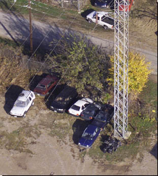
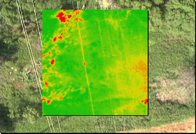
A second advantage of such a system is that the end-user receives a digital copy of the entire project in addition to other deliverables such as reports, mosaics and CD-ROMs. Because the end-user has the ability to refer back to the captured data, a broader evaluation of the surveyed area is permitted. A 'big picture view" of the area is an integral tool in the planning and decision making process. An expanded information base allows utilities to accurately prioritize and determine which areas require immediate attention and the data archival capabilities allow comparisons of changes in features over time. For example, the visual and thermal imagining data can be used for regulatory and environmental compliance now and at later dates. As well, other departments within the organization who want to examine unrelated inspection and positioning issues, such as road conditions, or property lines can use these images. Overall, the system is designed to be a cost-effective alternative solution to existing methods of asset inventory and inspection.
 |
The integrated airborne data acquisition system consists of two separate, but closely related, systems: the Flight and Processing Platforms (Detailed Component Overview).
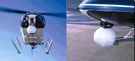
The Flight Platform includes the hardware and software necessary to collect high-resolution digital and infrared imagery, GPS positioning, and aircraft attitude data. Specific components of the Flight Platform include: helicopter-mounted turret containing cameras and aircraft attitude sensors, Differential GPS position and aircraft attitude measurement system, computer system custom-designed for flight applications, and flight planning software.
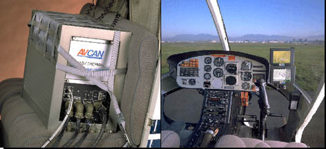
The Processing Platform is designed for the end-user of the data and allows detailed mission planning, image processing, custom reporting, and data export to various applications. Specific components of the Processing Platform include: software for planning flights, managing data, reporting, creating mosaics, and image analysis and a computer system custom-designed for processing software.
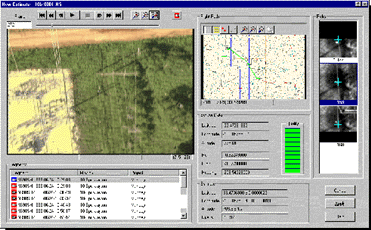
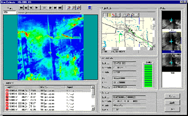
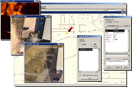
Information captured by the integrated airborne data acquisition system can be transferred to GIS software as point features with associated images for each item. In general, the data sets consist of GPS coordinates of all assets and point of interest, an attribute table, and digital infrared and visual imagery. Subsequent analysis might also include corridor mosaics and detailed inspection reports. GIS software allows an end-user to easily organize and view the inspection and location data collected and processed by the integrated airborne data acquisition system.
AVCAN developed PUMA (Power Utility Management Application) to complement the data acquired and processed by the Flight and Processing Platforms. The result is an ArcView extension that incorporates the data gathered into a geographically enhanced user interface. Designed for portability, PUMA allows an end-user to take this system out into field to perform as many updates to the database as required.
In March 2000, the Electrical Power Research Institute (EPRI) published a report that evaluated the effectiveness of using an integrated airborne data acquisition system to inspect and inventory transmission lines. The title of this report is "Airborne Inventory and Inspection of Transmission Lines: AVCAN Systems Corporation's Helicopter Patrol System (HPS)." This report demonstrated the ease and effectiveness of using an integrated airborne data acquisition system to populate a GIS database.
EPRI's objectives in studying AVCAN's System were:
The results of this study as reported by EPRI were:
"The AVCAN aerial patrol system was successfully used to collect digital still and video imagery (both visual and infrared) and to map the geographic coordinates of power line support structures and other points of interest within the right-of-way. The imagery collected by the aerial patrol system is suitable to identify a significant number of transmission line conditions and defects commonly encountered in the field. The in-office interpretation of digital imagery provides an inspection process at a very competitive normalized cost per condition/defect in comparison to traditional aerial patrol methods." (Ostendorp, M. 2000)
The integrated system developed by AVCAN has been used by various end-users predominantly in the utility sector. The speed, quality, accuracy and cost efficiency of this method make it a strong alternative to other inspection and mapping methods in use today. Some examples are listed below.
Transmission Corridor Inventory and Inspection - 3,000 km
This project required AVCAN to provide digital DTV, IR and still images of all structures for 3,000 km of line for Western Farmers Electric Cooperative. Deliverables include supplying original media and a processing platform and training for WFEC personnel to do their own processing. WFEC successfully used the data to populate their GIS.
Aerial Survey of a Proposed Fiber Optic Corridor - 40 km
This project required AVCAN to provide a detailed digital and printed Mosaic of DTV for a 40 km stretch for Telergy. Infrared and high-resolution still images of potential problem areas were provided. Deliverables included supplying the digital images on CD and providing a written report of the DTV mosaics and any anomalies. Mosaics were imported into AutoCAD at 1:50 scale by the customer to use as a base map for their engineering purposes. Data was also used to successfully populate their GIS.
Transmission Corridor Inventory and Inspection - 1,760 km
This project required AVCAN to provide digital DTV, IR and still images of the 12,000 towers and 1,760 km of line for TXU. Deliverables included supplying the digital images in CD format and providing a written report of any anomalies with location and images.
Aerial Survey of a Proposed Pipeline Corridor - 53 km
Flown along the Right of way of existing powerlines, this project for the Pogo Onshore Pipeline Company required AVCAN to perform a detailed corridor survey on 53 km of open terrain to support the location and engineering of a gas pipeline. Deliverables included producing a hard-copy (mosaics) report and supplying the client with a digital data file (DLT tape).
An integrated aerial data acquisition system suitable for inventory and inspection of electric power lines was discussed. This unique system provides the advantages of traditional inspection and inventory methods, with the speed and low-cost data acquisition of aerial patrol.
The integration of new technology (high-resolution digital photography, DGPS, improved IR sensors, and inertial navigation) allows utilities to collect vast amounts of accurate location and up-to-date attribute data for use in a utility's GIS.
Case studies involving the Electrical Power Research Institute (EPRI) and other utilities demonstrate the ease of using an integrated aerial data acquisition system to effectively populate a GIS.
Bishop, Jean, AVCAN System Corporation
Ostendorp, Mark PH.D, P.E., EPRIsolutions
Stefanitsis, Christine, AVCAN System Corporation
Ostendorp, Mark, 2000, EPRI - "Airborne Inventory and Inspection of Transmission Lines: AVCAN Systems Corporation's Helicopter Patrol System (HPS)"
| Phone: | 604 654 1850 | |
| Fax: | 604 654 1880 | |
| E-mail: | richard@avcan.com | |
| Web Address: | www.avcan.com |