Bringing GIS to the Center Stage at the Idaho Department of Water Resources
David R. Tuthill, Jr.
Michael H. Ciscell
Anthony Morse
Abstract
During the past few years the Idaho Department of Water Resources has begun a transformation from tabular records keeping to spatial digitization. Led by pioneering work from the Idaho Geographic Information Center, the regulatory arm of the agency has found that ArcView brings powerful GIS capability to the user level. This paper presents the trials, tribulations, challenges and joys of spatially enabling the rank and file of a resource agency. Aspects range from migration of the database, to spatial examination of business processes, to changing the agency culture to include spatial awareness.
Introduction
The Idaho Department of Water Resources (IDWR) is the agency of state government responsible for planning and management of water and energy resources throughout the State of Idaho. Since the formation of its predecessor agency in 1903, IDWR has been the repository of water measurement and water right records. This information was initially recorded in paper formats, was preserved with microfiche beginning in the 1960s, and was computerized with tabular data entry beginning in the 1970s.
Spatial attributes of data have been recorded on maps throughout the century. Locations have also been depicted where possible within the Public Land Survey (PLS), using the Boise Meridian to locate townships, ranges, sections, and tracts as small as sixteenth sections (40 acres). On rare occasion, for example to describe the location of a spring, a tract has been recorded to the nearest 10-acre parcel. PLS information has been stored in the tabular database, which for the past 15 years has been ADABAS.
Idaho Geographic Information Center
While the regulatory arm of IDWR continued to compile data throughout the state in a tabular format, the planning and analysis arm of the agency developed significant remote sensing and GIS expertise and capability. In 1978, the Governor recognized the importance of remote sensing and associated spatial-data processing. He issued an executive order creating the Idaho Image Analysis Facility (IIAF) within IDWR, and designated IDWR as the lead state agency for these technologies. In 1992, a subsequent Executive Order changed IIAF's name and mission. IIAF became the Idaho Geographic Information Center (IGIC), and the emphasis was changed from remote sensing to GIS.
IGIC now has considerable GIS and remote sensing horsepower. There are thirteen full- and part-time GIS and database professionals using twelve ARC licenses, SDE, MapObjects, ArcView, ERDAS, and ER Mapper. IGIC personnel have worked under contract on projects for USGS, BLM, the US Forest Service, the Bureau of Reclamation, EPA, other Idaho state agencies, and several private sector firms.
History of spatial analysis at IDWR
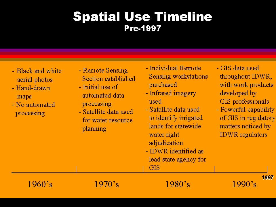
During the first eight decades of the twentieth century there was little change in spatial analysis capabilities at IDWR. As depicted in Figure 1, by the 1960s black and white aerial imagery was used, but this imagery was little better than the imagery that was made available by aircraft photographs from World War 1. With the addition of satellite imagery prepared by IGIC beginning in 1980, IDWR enjoyed a major step forward in capability. Phase 1 of spatial enablement is considered to have begun at that time. This initial phase, which can be characterized as the "technical capability" phase, lasted for the next 10 years as one to five workstations were in place. The increase in numbers of GIS workstations is shown in Figure 2.
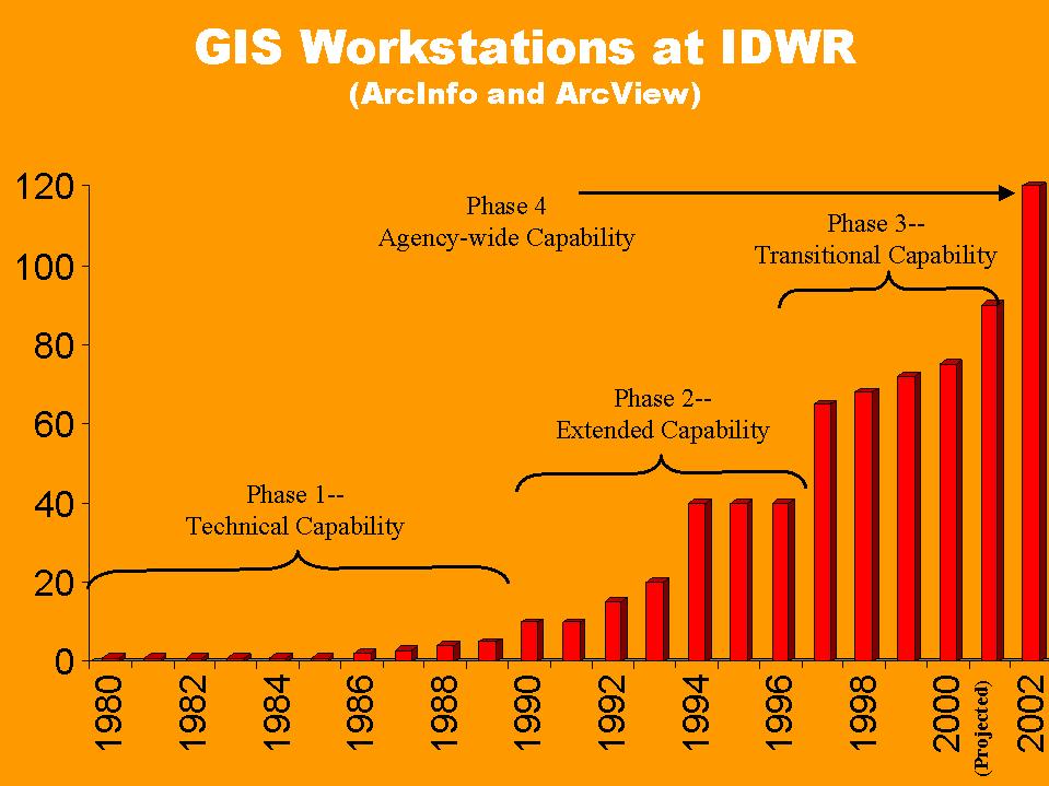
Beginning in 1990, additional workstations were added, enabling an increase in IGIC capability. In addition to various mapping projects, in 1990 IGIC conducted a major project for the Snake River Basin Adjudication by using remote sensing and GIS to (1) map irrigated lands throughout the state, and (2) summarize the irrigated acreage by 40-acre tract. This represents the first time that IDWR had used remote sensing and GIS on a widespread scale for regulatory purposes. From 1990 through 1996, spatial enablement is considered to have matured to Phase 2, "extended capability."
T8S R22E Pilot Project
In 1996, IGIC personnel developed a pilot study for the Snake River Basin Adjudication (SRBA), designed to show how the power of GIS could be applied to the SRBA. The pilot was an ArcView application showing the SRBA water right claims, assessor's tax parcels, and scanned, map-registered aerial photographs for one township of SRBA claims.
The township chosen for the pilot was T8S, R22E, a township that had already been evaluated by the SRBA, and had gone through the full SRBA quality-control process. Despite this extensive tabular QC work, several problems were immediately obvious on displaying the water right claims on top of the aerial photos. Several irrigated fields had no claims registered, and two claims appeared to be located on un-farmed rangeland.
The addition of the assessor's tax parcels proved to be a boon. The SRBA process was never designed to track changes in water right ownership, which meant that IDWR had no practical way to contact people if they were not the original claimants. However, the parcel data allowed IGIC personnel to quickly identify the owners of the problem parcels. The parcel data also showed that the Federal Government owned the land on which the two claims on un-farmed land were filed. As it turned out, the claims were actually filed on T8S R21E, and were included in T8S R22E because of a data-entry error.
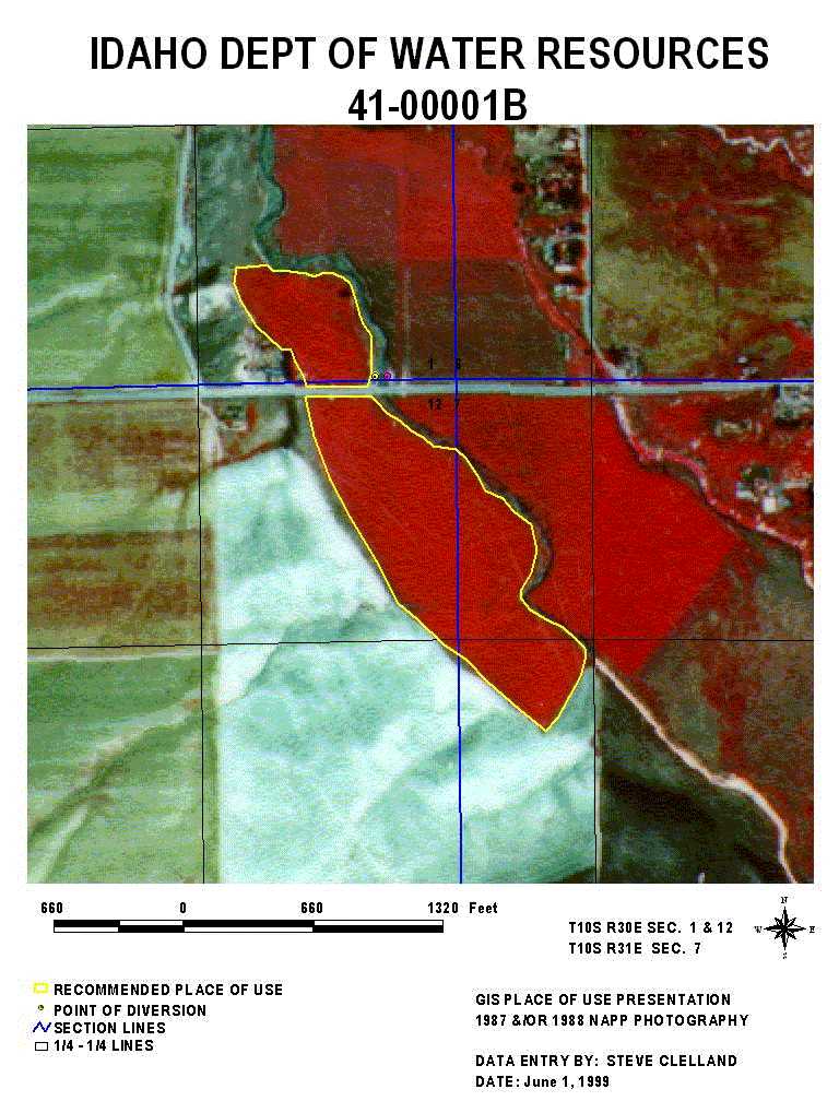
Adjudication personnel quickly realized the utility of even a simple GIS pilot project to their task. From that point, the Adjudication Bureau decided to use GIS by preparing a shapefile for each water right utilized for irrigation purposes within the Snake River Basin. This process results in the preparation of a layout for each irrigation water right similar to the one depicted in Figure 3. About 10,000 shapefiles have been prepared to date, and a total of 30,000 are anticipated to be created by 2005.
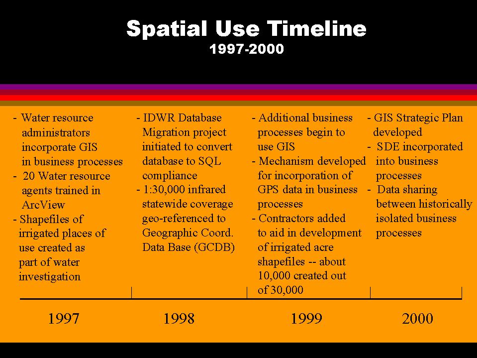
As depicted in Figure 2, 1997 represented a major increase in spatial analysis capability within IDWR. In that year 20 additional personnel were trained on and began using ArcView. Based on the success of this program, IDWR is now utilizing ArcView for additional business processes. Shapefile preparation for a portion of the water right transfers was added in 1999, and additional regulatory processes will be added over the next three years. Figure 4 identifies some of these major spatial events during the period from 1997 through 2000.
Role of Database Migration in Spatial Enhancement
When the SRBA began creating shapefiles of irrigated parcels in 1997, three findings became clear. First, the creation of layouts such as the one shown in Figure 3 has a powerful effect on public acceptance of agency recommendations and the resolution of objections arising in the adjudication of water rights. To capitalize on this finding, the water right adjudication effort within IDWR has endeavored to incorporate GIS throughout its water right analysis and preparation. Water right claimants, the SRBA Court, and IDWR staff at every level, from agents to senior management, have deemed this effort a success.
Second, while a tabular database can be adjusted to conform to a spatial representation of the water right, it is cumbersome to integrate the tabular and spatial systems using an outdated, non-relational tabular database. To address this finding, IDWR embarked on a two year, $1.6M effort to migrate its water right, adjudication, and well construction database from ADABAS C to SQLServer. The IDWR Database Migration Project is scheduled to be completed by August 30, 2000. While much functionality has already been developed, fast and seamless interaction between the tabular and spatial databases has not yet been achieved. IDWR looks forward to a productive summer of debugging and training in anticipation of more extensive utilization of this technology.
The third finding is that management and housekeeping of spatial data is challenging when shapefiles are being created on an agency-wide basis. To address this finding, IDWR assessed the applicability of Esri’s Spatial Database Engine (SDE) and chose to attempt to implement the software even though applications at this scale are rare. This implementation is part of the IDWR Database Migration Project. While implementation of SDE is not critical to the success of the migration project, IDWR is seeking the enormous benefit in records maintenance and spatial functionality that SDE has the potential to provide. Thus, SDE interface and functionality are being attempted as part of this project.
Impact of Agency Culture on Spatial Enhancement
The transition from using spatial data in a tabular form to using spatial data in GIS is a major change. Such major changes in the way organizations work are usually adopted at different rates within an organization, and IDWR has been no exception. To understand impediments to the use of spatial techniques, it is useful to understand both the structure and the history of the department.
IDWR as it now exists was formed in the early 1970s by the merger of the State Engineer's Office and the Idaho Water Resource Board. The two organizations had very different responsibilities and functions. The State Engineer's Office regulated water through issuing water rights and supervising water distribution. The Water Resource Board was responsible for water planning and the technical studies that supported their decisions. These different functions and associated cultures have been preserved to some extent by the present IDWR organizational structure.
IDWR has three divisions: the Energy Division, the Water Management Division (WMD), and the Planning and Technical Services Division (PTSD). The WMD incorporated those functions inherited from the State Engineer's Office. The PTSD includes the staff that supports the present Idaho Water Resource Board as well as the GIS section. The GIS section came to be in the PTSD through IDWR participation in the NASA Western Regional Applications Program in the late 1970s.
The structure and history of the department has had two impacts on how GIS functioned in the department. The first impact was that the business processes within a division were considered to be within the purview of that division alone. Project review and budgetary approval was done within the division. The second impact was that, since GIS was a PTSD function, the WMD sometimes did not incorporate GIS because it was largely a function of "the other division."
Due to IDWR's early participation in the Western Regional Applications Program, the Governor issued an Executive Order that designated IDWR as the lead state agency for remote sensing and GIS, and established the Idaho Image Analysis Facility (now the Idaho Geographic Information Center) within IDWR. For about twenty years, GIS evolved in the PTSD to the degree that in 1998, Esri included IDWR in the first group of Special Achievement in GIS awards.
During this evolutionary period for GIS, the funding structure varied from one IDWR division to another. The PTSD received grants and funding for research, and was able to purchase hardware and software with these grants and advance technologically. Meanwhile, the WMD relied primarily on more restrictive State of Idaho general funds. Thus, the divisions evolved at different rates relative to implementation of new technologies.
By 1997, IDWR had considerable GIS resources available, but these resources had not been widely used in regulatory applications. GIS remained largely unused due to historical, structural, organizational and funding reasons that were unique to IDWR, but are not unusual in the broader sense. It required a compelling example of the power of GIS, in the form of the T8SR22E demo, availability of implementation funds, and a recognition on the part of a few key managers that things had to change in order to overcome impediments to progress.
Impact of the GIS Strategic Plan
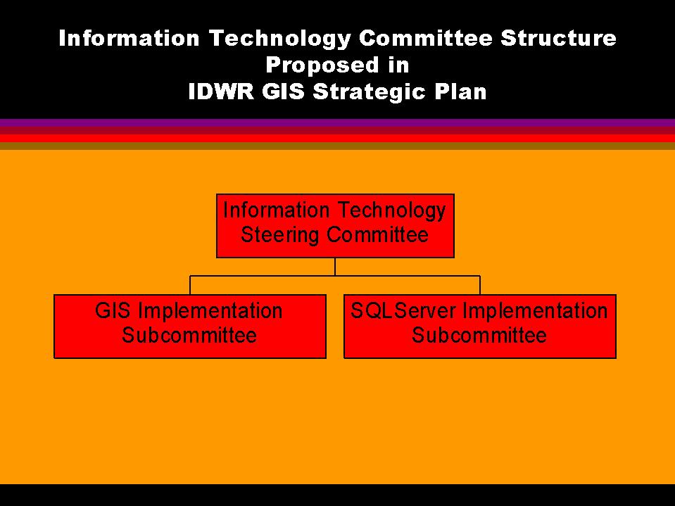
During late 1999 and early 2000, IDWR worked with a contractor, Marshall and Associates, to develop a GIS Strategic Plan. The plan, which is now in the review stage, concludes that IDWR is on a good track toward GIS utilization, and establishes guidelines for enhancing GIS capabilities over the next three years. Figure 5 identifies the committee framework suggested in the plan, whereby IDWR continues to conduct an agency-wide Information Technology Steering Committee, and adds two subcommittees. The first is a GIS Implementation Subcommittee tasked with the responsibility of aiding business processes throughout the agency to become spatially enhanced. The second is a SQLServer Implementation Subcommittee tasked with the responsibility to facilitate the migration of additional business processes to SQLServer.
Migration of the data to SQLServer, and assembling spatial data in SDE, provide opportunities for powerful Internet access applications. IDWR reviewed software packages for this purpose, and has recently initiated a test of ARC/IMS. The agency will be testing this product this summer, utilizing efforts of personnel from both PTSD and WMD. The GIS Strategic Plan provides for ongoing agency-wide participation in the review and introduction of this type of technology.
Future of Spatial Enhancement within the Agency
As projected in Figure 2, the future of spatial enhancement at IDWR appears bright. Experience has shown that water users appreciate the value of the adage that "a picture is worth a thousand words." IDWR is committed to moving forward to develop tools that will enable full exploitation of spatial capabilities both for internal purposes, and for providing information to the public. This forward movement now has widespread participation that helps to dispel the organizational and structural impediments of the past. The year 2000 has the potential to be a truly transitional year for the agency in terms of both spatial awareness and utilization. Working cooperatively and across division lines, widespread effort is being applied to make this happen.
Author Information
David R. Tuthill, Jr.
Michael H. Ciscell
Anthony Morse
Idaho Department of Water Resources
1301 N. Orchard
Boise, ID 83704
(208) 327-7929
Fax: (208) 327-5400
dtuthill@idwr.state.id.us