| Internet Map Server for Public Works |
Author:
|
Mostafa A. Ghanem, GIS Consultant idea integration mghanem@idea.com | Master's of Urban Planning, Texas A&M University Graduate Studies in Environmental Planning, Alexandria University; B.Sc. Architecture, Alexandria University |
The Graphics and Engineering Management division for the City of Houston's Public Works and Engineering (PWE) Department is responsible for maintaining map data related to the wastewater, water and storm drainage utility systems. In 1988, the Public Works department initiated a project to convert the utility system maps from paper and ink on mylar to digital format and to develop the associated database. The project output was 2,500 map tile each covered about 3,275 by 2,150 feet. The utility system comprised of: 6,500 miles of wastewater lines and 103,000 manholes; 2,800 miles of storm drainage lines and 78,000 inlets; 7,300 miles of water lines, 45,000 fire hydrants and 120,000 valves. In 1996, Idea Integration was contracted by PWE to develop the Geographic Information Management System (GIMS) to manage their GIS data. The GIMS system was to accomplish the following objectives and functions:
- Maintain the digital Maps of the Utility layers in a secure, multi-user environment.
- Locate and view desired Utility features anywhere in the City in a near-instantaneous manner.
- Provide support for integration of Work Order Tracking and Engineering databases.
The consultants of Idea Integration analyzed the existing data model and developed some strategies for a modified storage scheme that might better serve the desired objectives. The new data model focused on reducing the number of coverages that represent each tile and on eliminating the redundant representation of data. Results of the testing effort was presented to the City and alternatives were evaluated. A transactional ARC/INFO Library was selected as the target data structure. The utility maps were aggregated by layer and modifications were made to the database structure prior to insertion into the Library. To manage the library transactions and to avoid collisions, several UNIX-based deamons were written using Perl programming to queue the users requests. Also, a deamon program was implemented to generate unique identification number for map features.
| GIMS System Architecture |
A suite of custom software application programs designed to operate in the ARC/INFO environment were developed to manage and maintain the utility system map tiles. The custom applications were designed to provide specific functionality desired by the map maintenance group through Arcedit, and for near instantaneous access to the Utility data in the Arcplot environment. The map management applications is comprised of five AML-based programs that are as follows:
- GIMSEXTRACT allows the map maintenance personnel to "check out" map tiles from the library into a write protected workspace for each user
- GIMSEDIT provides a GUI-based ARCEDIT session through which editing tasks can be performed on map tiles
- GIMSAUDIT provides the ability to send tiles between users and supervisors to QC the map edits
- GIMSPLOT provides numerous plotting capabilities for hardcopy output of GIMS maps
- GIMS Query & Display (Q&D) provides near-instantaneous access to the GIMS data
| GIMS Q&D System |
The GIMS Q&D has become a very popular application throughout the City of Houston department, since it provides access to the GIMS data and other 100 GIS layers to every employee who has a computer on his desk and connected to the City network. In addition, two UNIX terminals were made available at the G&EM office for the public to access and view the GIMS utility layers. These stations have become a key element in providing service to the public, city contractors and service request applicants who need to locate utility lines adjacent to their properties. The increased maintenance of these stations triggered the need to make the maps more accessible to the public at a reduced cost was realized through the development of and Internet Map Server. Figure 1 shows a diagram of the GIMS system structure.
The Q&D application provides a GUI-based ARCPLOT session for graphic and/or attribute query with subsequent screen display and/or hardcopy plot output of the query results. Every evening, a citywide coverage for each of the waste, water, and storm layers is generated from those same layers contained in the transactional library. Spatial and item indexes are applied to these coverages and a copy of each is updated onto 6 different UNIX servers located strategically throughout the City. Presently, over 200 users at many locations throughout the City departments have access to GIMS through Q&D. Most of these gain access with their desktop PC's running X Window emulation software through a TCP/IP connection to a nearby UNIX server running ARC/INFO. Because specific utility symbology and annotation are important to the entire operation when accessing the utility layers, ARC/INFO over ArcView is the desktop choice for viewing GIMS data.
| GIMS Internet Map Server |
With the increased demand on gaining access to the GIMS Q&D by the different departments and the limited number of Arc/Info licenses available at the PWE, a need for an internet based became a necessity. In spring 1999, the GIMS manager asked Idea Integration to evaluate the different Internet GIS software produced by Esri. An evaluation copy of Arcview IMS and MapObjects IMS software were obtained from the local Esri office for testing and evaluation with the GIMS data layers. The outcome of the evaluation process recommended utilizing MapObjects Internet Map Server for development of the Internet based GIMS system. The MapObjects IMS was selected because it provides a wide array of tools for map analysis and manipulation over the Internet and can be developed easily using Visual Basic, which was a preferred development environment. The GIMS manager objective was to have an Internet application that allows the following:
- Develop a PC based application on a Windows NT4.0 environment
- Maintain the security of the GIMS UNIX servers
- Provide access to the utility layers database and other selected land base maps
- Provide an up-to-date information by providing access to the data daily updates
- Provide tools and information to assist the user in accessing the utility maps and the GIMS personnel
- Provide tools to enable the users to locate places on the map by address, key-map number, zip code, tax-id or wastewater meter basin number
| Design Process |
With the above objectives in mind, the system was designed using MapObjects 2.0 with Visual Basic 6.0 for the application and HTML for the web pages development. The MapObjects Map Server was implemented with the use of Internet Information Server, which provides the connection to the world wide web. The map sever is a three tier application that consists of the server, the application and the client. The development process involved three stages.
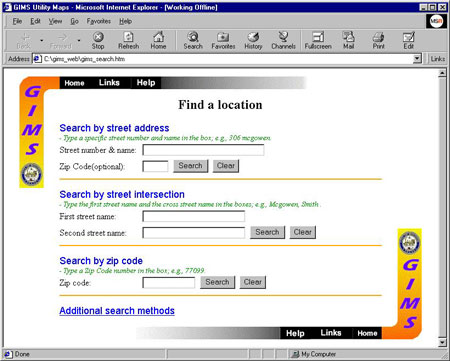
The first stage was to design the internet map page that will be served by MapObjects IMS. To reduce the network traffic, the map page is accessed through an HTML form page that enables the user to view the map by entering an address, street intersection, key-map page number, a postal zip code, property tax-id or a wastewater meter basin. This is done by sending a request to the map server, which returns a JPEG image of the utility map (figure 6). Once the user has accessed the page he can change the layer combinations viewed on the map, list information from the different map layers and change map scale.The second stage was to setup a process to update the utility maps on a daily basis to reflect the latest changes in the database on the Windows NT server. The map data consists of a set of land base maps that are static and the utility map layers that are updated on a daily basis. The update process was done by setting up a daily process that runs after midnight on UNIX to collect the utility maps generated on the GIMS server and FTP them to the NT server using a combination of Perl and AML programs. The connection is set to allow access from UNIX to the map server only to maintain the security of the GIMS.
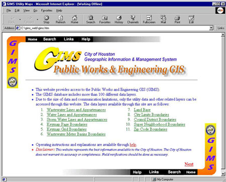
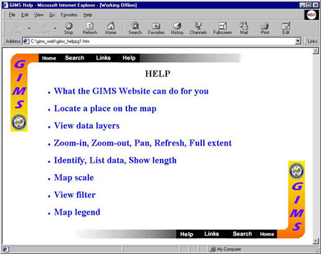
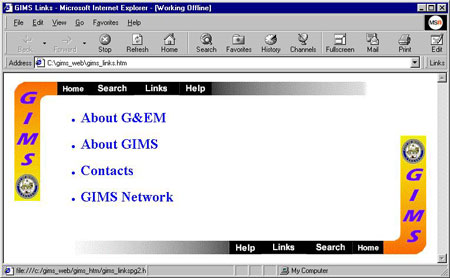
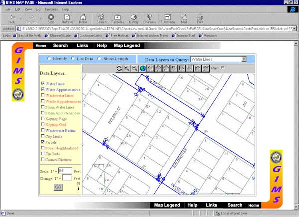
The third stage was to design the web site that would support the map page. The web site comprises of a home page that provides a brief description of the web site and provides links to other supporting sections. Figure 2 shows the GIMS home page. The support sections consist of a help section, a links section, and a map search section. Figure 3 shows the help section and which consists of links to several HTML pages that describe how to access the map page and use the utilities provided. Figure 4 shows the links page and which connects to several pages that provide information page about the PWE department, a background page about the GIMS system and a list of the people to contact for questions at G&EM. The search page provides several search methods and which is the only access to the map page. This was done to reduce the load on the server and to help the user find the desired location on the map. Figure 5 shows the search page and the different searching methods provided such as street address, street intersection, postal zip code and a connection to more searching mechanisms on another page. Figure 6 shows the HTML map page.
| Map Server Implementation |
The implementation of the GIMS Internet map server is accomplished using a Windows NT4.0 at the City of Houston web page server location. The map server is connected to the City wide area network and the GIMS Unix servers through a TC/IP over a T1 connection.
| Conclusion |
The City of Houston GIS has proven an effective tool in managing and maintaining geographic data for the utility sector and accessing the GIS data on the Internet is becoming an key tool in making public information more accessible to the public while maintaining low overheads.