This project will assess existing riparian habitat from classified TM imagery along the major drainage areas within the five coastal counties of the Texas Coastal Bend. The project objectives are to evaluate the late 1990's status of riparian habitat corridors, and to develop recommendations for riparian habitat preservation and/or restoration. GIS analyses will also yield adjacent land use within each riparian watershed. Groundtruthing will verify location, extent and dominant plant type of each riparian habitat. GIS data will be compiled on a watershed basis as hard-copy maps of existing riparian corridors, and in an ArcView digital format for use in a potential restoration and preservation site catalog.
The Corpus Christi Bay National Estuaries Program (now Coastal Bend Bays and Estuaries Program-CBBEP) was established in 1993. During the characterization phase of the CBBEP, considerable investment was made in characterizing eight major estuarine habitat types at a broad, landscape scale. Those status and trends analyses were useful for establishing baseline inventories of coastal estuarine habitats and for guiding the development of actions for the Coastal Bend Bays Plan (CBBP). As the Program moves into implementation, it was deemed necessary to have a more detailed inventory of riparian habitats and to develop a strategy for protecting remaining functional riparian habitat. Riparian habitat has been selected as an important starting point due to the multi-faceted functions it serves, including surface water filtration, soil erosion control, and wildlife habitat. Results of this project will provide detailed baseline information about the status of riparian habitat including areas in need of protection and restoration. This information will be valuable in the next phase to develop preservation and restoration strategies for each prioritized site.
This project was developed to assess existing riparian habitat along the major drainage areas within the five coastal counties (Refugio, Aransas, San Patricio, Nueces, and Kleberg) of the Texas Coastal Bend. The existing riparian habitat will be inventoried including habitat quality and areal extent, the vegetative communities described including dominant species and community structure, and areas identified that exhibit the greatest potential for threats from urbanization and those in need of restoration. This paper focuses on the characterization of riparian habitat within the Oso Creek watershed in Nueces County. The processes used in this characterization will be repeated for the other watersheds within the project area. Therefore, the objectives of this project are to: 1) evaluate the extent and location of riparian habitat corridors within the Oso Creek Watershed; and, 2) develop recommendations for riparian habitat preservation and/or restoration in relation to riparian habitat functions for this creek system.
Tasks associated with these project objectives involved metadata procurement and reprojection from several sources, including state and federal agencies and educational institutions. These datasets were utilized to determine watershed size, stream complexity, riparian habitat locations, and adjacent land cover and uses. The use of ArcView GIS facilitated the compilation of these datasets in a compatible format for analyses. Hard-copy maps were generated to assist in identifying and in an ArcView digital format for use in a potential restoration and preservation site catalog.
Several layers were necessary to accomplish Objective 1. The Texas Parks and Wildlife (TPWD) dataset identifies landuse/landcover types for uplands, wetlands, and transitional lands throughout the Texas Coastal Bend. This dataset was provided with a scale of 1:24,000 or 30-m resolution by TPWD Coastal Studies Program, Resource Protection Division (Pulich and Hinson, 1996). The creeks and drainage patterns in the Oso watershed were downloaded from Texas Department of Transportation (TxDOT) (
The U.S. Fish and Wildlife Service National Wetland Inventory 1992 (NWI) dataset was imported from Texas General Land Office WetNet Webpage (
The ArcView layers were utilized to identify riparian habitats and adjacent upland landuse types by creating a buffer zone one mile in width from the floodplain zones. After scanning the floodzone map of the Oso Watershed area from the Environmental Geologic Atlas of the Texas Coastal Zone, the image was aligned to the TxDOT rivers layer. The floodzone was delineated by digitizing a new line layer around the pixels defining the extent of flooding. The one-mile buffer was then created around the defined floodzone. The buffer was used to define the limits of wetlands, riparian habitats, and upland landuse/landcover that correlated with the Oso drainage areas. Calculations of acreage were repeated using methods previously described for the TPWD and NWI datalayer within one-mile buffer. Comparisons were conducted to identify proportion of natural habitats to converted landuse types for the watershed and buffer scales.
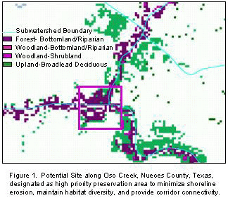
The overall goal of the this project was to determine where riparian habitat occurs within the Oso Creek Watershed, what types of land uses occur within and adjacent to the floodplain, and what types of alterations have occurred to the riparian habitats in selected areas. Topographic, stream location, floodplain designation, national wetland inventory, and natural resource inventory data were needed to assess location and extent of riparian habitats within the study area (Figure 1). These ArcView layers were used to identify areas that are: 1) in immediate need of protection from development, 2) areas that have been cleared of riparian vegetation and could potentially be restored to increase habitat connectivity, and 3) areas that could serve a reference habitats for restoration and enhancement projects. Location of these areas were georeferenced using the Identification tool for determining coordinates in ArcView and hard copy maps will be used to groundtruth these potential sites. The sites selected for protection and/or restoration will be listed in a catalog in association with the ArcView project information and maps.
Several issues were raised during the development of this project. The DEMs downloaded from USGS with no problem. However, during the conversion to Lambert conformal conic, the transformation left areas of missing data along gridlines. The void areas were on portions of the edge between quads resulting in QA/QC uncertainties. The same problem occurred with the NWI dataset. During digitizing, portions of the data along grid lines were lost along with a minimal number of vegetation polygons. When the NWI data was relied on after unioning polygons across the gridlines, the portions with no data became apparent. The dataset will be groundtruthed in critical areas and compared to hard copy maps before being used in other watersheds. In continuing analysis for the Texas Coastal bend region, the missing data will be digitized as a new layer. While the NWI and TPWD land use datasets were very useful for analysis, they did not overlay each other until the necessary projection transformations were complete. This caused a slight delay in the analysis of the Oso watershed. In targeting the TPWD land use datebase, we found that the image was very useful for analyzing the coastal counties. However, the dataset does not allow geographic analysis to cover the extent of some watersheds, since the data is limited to the coastal region. Any further analysis on a watershed level will require data that extends inland. Many digital sources for floodzones in the targeted region were not available at a scale needed for this project. The floodzones were simple to delineate after finding an appropriate source. The final source required scanning the hard copy map and georeferencing the data to the TxDOT dataset before reliable digitizing could continue. Despite data gathering and reprojection challenges the resulting ArcView project will provide a unique, and valuable tool in the identification, protection, and restoration of essential riparian habitats.
The following people were very helpful in the development of this ArcView GIS: Ms. Suzanne Dilworth, Center for Coastal Studies, Resource Specialist; and, Mr. Oscar Cantu, GIS Research Assistant, Mr. Osbaldo Cantu, GIS Research Assistant, Miss Amy Longfield, Graduate Student; Mr. Michael Villareal, GIS Graduate Research Assistant at Texas A&M University.
Brown, L.F., Jr., J.L. Brewton, J.H. McGowen, T.J. Evans, W.L. Fisher, and C.G. Groat. 1976. Environmental Geologic Atlas of the Texas Coastal Zone - Corpus Christi Area. Bureau of Economic Geology, The University of Texas at Austin, Austin, Texas.
Pulich, W., Jr. and J. Hinson. 1996. Development of geographic information system data sets on coastal wetlands and land cover. Coastal Studies Technical Report No. 1, Texas Parks and Wildlife Department, Resource Protection Division, Austin, Texas.