

|
|
The Japanese islands of Honshu and Kyushu are home to numerous United States military installations belonging to all the DOD services. In 1998, PWC Yokosuka began providing GIS implementation services to various U.S. Military Commands in Japan and now serves as the Regional coordinator for Navy GIS implementations Japan-wide, excluding Okinawa.
 |
PWC Yokosuka's GIS management function rests within the Engineering Department. The GIS staff consists of one U.S. Civil Service employee and three Japanese national employees. The PWC Information Systems group is responsible for system procurement, configuration and end-user support for issues not related to using GIS software. Data maintenance is distributed among functional users of various departments who work with the data on a daily basis. This frees the GIS staff to focus on the implementation of the technology and resolving various data- related issues that arise. |
"Up-to-date" – The map should be no more than two years old. Old data is the biggest enemy to a successful implementation.
"Spatially accurate" – Overlay of survey-quality data onto the map is possible with reasonable results. For us, that means accuracy within plus or minus ½ meter.
"Geo-referenced" – The map is in a valid projection and coordinate system. This facilitates the addition of new data and maintenance of existing data.
"Topologically Correct" – The features that make up the map are drawn in a way that permits the GIS to recognize and use them properly. For example, buildings must be drawn as a closed polygonal boundary where all corners match exactly. Topology is the biggest barrier to using legacy CAD data in GIS.
"Spatially contiguous" – To the fullest extent possible, it is important for the land base to be seamless. All adjacent areas should be together in a single coverage. In the "old" days, areas were split up to keep file size at a minimum.
"SDS compliant" – Features should be named, broken out and/or aggregated in accordance with the latest release of the CADD/GIS Spatial Data Standards.The PWC Real Estate group is responsible for making regular updates to the digital existing conditions data. Other functional groups (utilities, planning, telecomm, etc.) then use this map as the foundation of their respective interface to the system. For example, the utilities department overlays their water, steam, etc. distribution systems onto the Real Estate Base map. The utilities department staff is then responsible only for the updates to their subset of data. The maintenance processes are set in conjunction with their existing work procedures. A new base map appears to them every three or four months when Real Estate publishes an update.
By sharing a common foundation, separate functional groups are able to share and make use of each other's data. For example, the Planning group is able to display utilities information as they make decisions concerning the future development of the base. By leveraging our data in this manner, the value of the system increases exponentially.
Data sets that are not a part of the base map can be loaded in two ways. Casual users who need to view the data, can load "data groups" as additional overlays. Advanced users who need to analyze the data can load an ArcView extension, which in turn will load the data and provide the user with additional functions necessary to run the application.
Variables are used in all of applications in lieu of hard-coded drive paths. Thus, users with different drive mappings (or using different machines) are able to customize the variables to suit their particular setup. The concept of applying variables in lieu of drive mappings is an essential one.
By building portability into the system design, it is easier to accommodate the change and growth of the system over time.
Future Improvement (line)
Future Improvement (poly)
Future Landform
Future Transportation
Future Buildings (line)
Future Buildings (poly)
Limits of WorkAll themes except the last are added directly from CAD data sources. The "Limits of Work" data source is the ArcView shapefile (previously mentioned) joined to the RPS tabular project data. The "Limits of Work" theme is then joined to the Future Buildings theme, allowing buildings to be queried on project information.
Display Future Facilities
Create GDP Layout
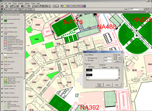
The Display Future Facilities button opens an ArcView dialogue that permits the user to form a query using the following parameters:
All projects
Projects based on program year (can be a range of years)
Projects based on Project Number, Project Title, or Phase
In addition to these standard criteria, queries can be executed from the ArcView interface, supporting ad hoc or complex queries. The user can also change the display properties of the selected limits of work, and the selected future projects are clearly labeled in the View.
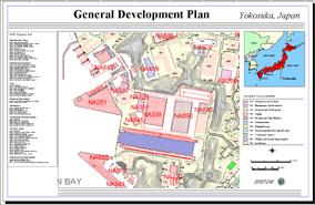
The Create GDP (General Development Plan) button creates a D-size color layout for the user that can be sent to a plotter. The layout incorporates a vicinity map, the current view display and a list of selected projects.
|
Ayman S.A. El-Swaify
CADD/GIS Manager Navy PWC Yokosuka, Code 400C PSC 473 Box 13 FPO AP 96349-1103 Phone: 011-81-311-34-7986 E-mail: elswaifya@pwcyoko.navy.mil |
|
Dale Dunham
Principal Geographic Information Services, Inc. 216 Aquarius Dr., Suite 319 Birmingham, AL 35209 Phone: (205) 941-0442 E-mail: ddunham@gis-services.com |