Shih-Lung Shaw
Abstract: Geographic information systems (GIS) are widely used at state DOTs and MPOs in supporting inventory, maintenance, analysis, and display of spatially referenced data. However, another important dimension of the data - temporal dimension - is often ignored or at the best treated as snapshots. Almost all transportation projects involve data related to the interactions between space and time. For example, DOTs need to analyze traffic accident data at different locations along a highway over a time period, or to simulate traffic flows at different locations in a city at different times in a day. Spatiotemporal GIS will be able to support these needs with better tools to query, analyze, and display spatiotemporal data. This paper presents several strategies to develop spatiotemporal GIS databases using Arc/Info and ArcView on historical traffic count data, travel diary data, and GPS-based vehicle tracking data.
Geographic information systems (GIS) have made significant impacts on the ways that we handle spatial data. These impacts are reflected not only by the wide range of GIS applications in various fields but also through the development of new data representation methods and analysis capabilities available to the GIS users. In the transportation field, we have seen many extensions to the basic vector GIS data model implemented in commercial GIS software (Goodchild 1998). For example, turn tables were introduced into the Arc/Info software in the 1980s for a more realistic modeling of vehicle movements in network analysis. In response to the large volumesof data based on linear referencing systems (LRS) that are maintained in state departments of transportation (DOTs) and metropolitan planning organizations (MPOs), Arc/Info also incorporated the dynamic segmentation data model in the early 1990s for users to more efficiently manage their LRS data. These extensions have greatly enhanced the capability of transportation professionals to develop new GIS for transportation (GIS-T) applications. Unfortunately, GIS software products currently available still lack of some important functions to support other critical GIS-T applications. One example is the recent development of intelligent transportation systems (ITS) applications. Certain ITS applications have requirements such as managing data at the traffic lane level or modeling traffic data at the disaggregate level. These needs require additional capabilities that need to be added to the current commercial GIS software.
Another major shortcoming of existing GIS software is the limited functionality of handling temporal data. Time is a critical element embedded in almost all spatial data. Pavement data, traffic flow data, land use data, traffic accident data, transportation project management data, along with many others, are not only spatially referenced but also temporally referenced. Their data values all vary with time. Pavement condition of a highway segment in 1998 is likely to be different from the pavement condition of the same highway segment in 2000. Traffic flow on a major street segment during the morning peak hour is often significantly different from the traffic flow data of the same street segment during the off-peak hours. As a result, space, time, and their associated attribute values cannot be completely separated. Traditional GIS applications, in most cases, deal with the data at a single point in time and therefore avoid the challenge of handling the time dimension associated with the data sets. This paper will attempt to address the importance of handling spatiotemporal data in transportation applications through the presentations of three different strategies using Arc/Info and ArcView. The next section reviews the literature of spatiotemporal GIS research. The third section uses three different transportation data sets (roadway characteristics inventory data, travel diary data, and simulated GPS-based vehicle tracking data) to illustrate three strategies of handling spatiotemporal data in Arc/Info and ArcView. The final section offers concluding remarks.
Research on the interactions between space and time can be traced back several decades. Hagerstrand (1970) proposed a space-time framework to illustrate the concepts of space-time path and space-time prism. A space-time path shows the travel path of an individual in a three-dimensional space (x,y,time), while a space-time prism defines the activity space that an individual can reach within a time constraint. Geographic information consists of three components: location, attribute, and time. Sinton (1978) suggested that one of the three components must be fixed and another component is controlled in order to measure the third component. For example, traffic volume data collected from an automatic counter are at a fixed location for a controlled period of time. On the other hand, pavement condition data recorded as mileposts along a highway collected from a field survey on a particular date have a "fixed" time component and "controlled" attribute values (e.g., good, average, or poor) in order to measure their locations along the highway. It is also possible to use the location as a control. The Landsat Thematic Mapper (TM) satellite imageries are composed of pixels at 30-meter resolution taken at a fixed time. In this case, attribute values are measured for each controlled spatial unit (i.e., 30m x 30m pixels) at a fixed time. In transportation studies, spatial units organized by political boundaries or traffic analysis zones can also be used as the control in the measurements of attribute values. Goodchild et al. (1993, p. 278) argue that "analysis of social process requires a time-dependent, multi-dimensional, relative space, rather than the static, two-dimensional, absolute view embedded in current GIS technology".
Although time has been recognized as an important component in geographic data, it received little attention in the GIS community until the 1990s. Langran (1992, p. 32) defines temporality as "a sequence of states punctuated by events that transform one state into the next". A state has duration, while events are treated as instantaneous points in time. For example, the 1990 census survey (i.e., an event) changed the census tract boundaries of the 1980s (i.e., a state). An event therefore often produces a new object version and leads to a new map state. The temporal changes of object versions and map states presents a major challenge to the design of temporal GIS databases. It is a common approach to considering time as a linear movement in one direction. This conceptualization of time is often found to be insufficient of handling real world complexity. For example, transportation planners commonly deal with forecasting future travel demands and analyzing alternative plans to meet the projected demand levels. In this case, the time line needs to have multiple branches. Each branch will represent a particular transportation plan and its possible outcome. In other words, time is multi-dimensional rather than uni-dimensional. Snodgrass (1992) indicates that we must maintain both world time and database time in a temporal database. World time is the time when an event takes place in the real world, while database time represents the time when the event is updated in the database. With the presence or absence of recording world time and database time in a database, four types of temporal database can be identified. A snapshot database does not maintain either the world time or the database time. A historical database deals with the world time only. It therefore can show the history of an event through a play back of the events according to the recorded world time. A rollback database keeps track of the database time so that the database can be rolled back to an earlier state. A bitemporal database must maintain both the world time and the database time.
It is a common practice to treat time as the fixed component in GIS databases and create a snapshot model. Each map layer in a snapshot model represents a given state of geographic data. The major shortcomings of snapshot model include data redundancy and a lack of temporal connections between the features stored in different map layers. For example, temporal changes of roadway alignment are difficult to analyze because they are represented as independent map layers representing the states at different times. Alternative models have been proposed to handle spatiotemporal data in GIS. The amendment model stores only changes (i.e., amendments) to the base state data (Langran 1992, Peuquet and Duan 1995). The space-time composite model carries the amendment model a step further. This creates a discrete object, with its own history, from the parent object when a change occurs in a GIS map layer (Langran and Chrisman 1988). However, the new objects reflecting the changes are stored in the original GIS map layer. As a result, topology between past and present features is maintained in the same database. Yearsley and Worboys (1995) propose a deductive model of planar spatiotemporal objects. Their model integrates abstract spatial data types over the geometric layer to construct a higher-level topological data model (i.e., spatio-temporal object layer). In the geometric level, one object may belong to several higher-level spatiotemporal objects. Each geometric layer object is attached to both database time and world time that represent the union of all times at which these higher-level objects exist. Donna Peuquet (http://www.geog.psu.edu/tempest) has developed a TRIAD model that includes three separate, yet closely linked models: a feature-based model (what), a location-based model (where), and a time-based model (when). Yuan (1999) suggests that a three-domain mode (spatial domain, temporal domain, and semantic domain) is needed to represent spatio-temporal behavior of geographic entities. She argues that, through the treatment of time as a temporal object instead of an attribute in GIS, both static and dynamic spatial changes can be modeled by dynamically linking to the objects with location-centered, entity-centered, and time-centered perspectives.
The different approaches reviewed in the last section indicate several possible ways of integrating temporal data into a GIS environment. In practice, there still exist difficulties of implementing spatiotemporal GIS. For example, few geographic data sets include both world time and database time. Furthermore, many functions that are required to implement the spatiotemporal GIS models discussed above are not available in the current commercial GIS software. As a result, most GIS applications today are implemented as a snapshot model. With a recent trend of moving toward a more object-oriented data model (e.g., the geodatabase data model in Arc/Info 8), users now can create features with custom behaviors and define relationships among features (Zeiler 1999). This trend offers a possibility for users to define temporal objects and/or spatiotemporal object layers as discussed above. However, additional research is needed to examine such spatiotemporal GIS implementations.
This section presents three examples of handling spatiotemporal transportation data within the Arc/Info and the ArcView environments. The first example is based on a historical traffic counts data set that is part of the Florida Department of Transportation's (FDOT) highway inventory databases stored in Oracle. The second example uses a travel diary data set collected from a travel characteristics survey conducted in Broward County, Florida (FDOT 1996). The third example builds a temporal dynamic segmentation GIS database using a simulated vehicle tracking data set with global position system (GPS) readings of (x,y) coordinates and time stamps. These three sample data sets are representations of diversified transportation data. One common characteristic shared by the three data sets is their locations can be rerpesented as features on a linear transportation network. Traffic count stations are referenced by their respective highway control section IDs and mileposts in the Florida state highway system. The travel diary data set includes the street addresses of trip origins and trip destinations of the reported trips. Each trip path then is mapped to a street network between the trip origin loacation and the trip destination location following the shortest path. The simulated GPS-based vehicle tracking data are first matched to the links on a highway network and then converted to individual routes under dynamic segmentation. In other words, all three data sets can be expressed as linear referencing data under the dynamic segmentation data model.
Dynamic segmentation data model defines a route system on a geometric network map layer. An Arc/Info route system consists of a route attribute table (RAT) and a section (SEC) table. Each route is identified with its unique ID in the route attribute table. Sections are either whole or partial arcs that make up the individual routes. Each section is defined by its from-measure and to-measure of distances along a given route. Sections that correspond to partial arcs are derived from the from-position and to-position, expressed as percentages of the corresponding arcs, in the section table. In addition, each record in a section table contains a route ID and an arc ID for linkages to the respective records in the RAT and the arc attribute table (AAT). The dynamic segmentation data model of Arc/Info serves as a foundation of implementing the three sample data sets.
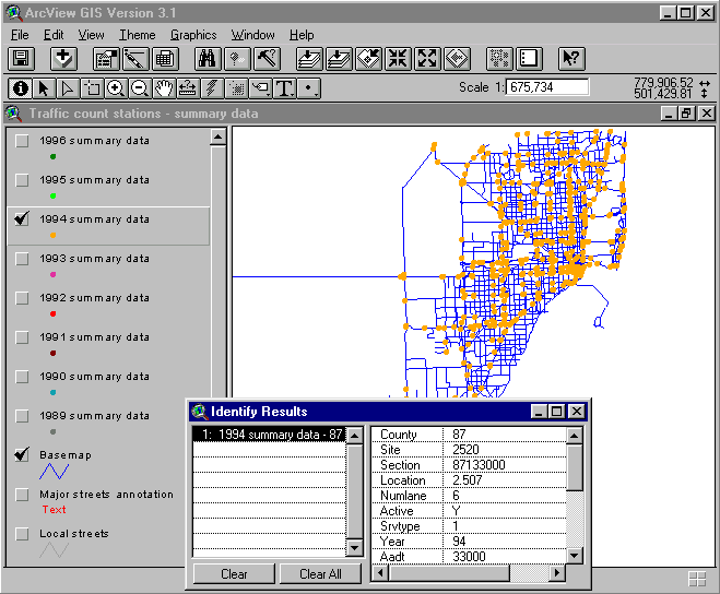
FDOT maintains a historical database of traffic counts collected at the traffic monitoring stations. Locations of the traffic monitoring station are stored in the database as a linear referencing system of control section IDs and mileposts. A basemap of the Florida's state highway system, with a defined route system of state highway control sections, is used to create GIS layers of annual traffic counts. Annual traffic count tables in Oracle are opened with the open database connectivity (ODBC) available through the ArcView. Separate GIS layers of annual traffic counts are created from the linear referencing data of traffic monitoring stations in Oracle tables and matched to the route system in the Arc/Info state highway basemap coverage (see Figure 1). This results in a historical spatiotemporal GIS of the annual traffic counts. Users can use the standard ArcView tools to query and display the annual traffic count data of any select year. Since the data are stored in a separate GIS point layer for each year, users do not have readily available functions to analyze and compare the change patterns of traffic counts between the GIS layers. In order to overcome this shortcoming, Avenue scripts are developed and incorporated into the ArcView graphic user interface (see Figure 2). Users can choose the "Analysis" menu option to launch the Avenue scripts. Dialog windows will lead the users to select the first year, the second year, a specific attribute data item, and a comparison method (difference or percent change). Once the Avenue scripts complete the computation process, a new GIS map layer that shows the change pattern of the select attribute item between the two user-specified years is automatically added to the View window. The Avenue scripts can detect numerical data items from text data items. If a user chooses a text data item (e.g., types of traffic monitoring device) for comparison, the output GIS map layer will show the monitoring stations with changes versus those without changes in different symbols.
Figure 1: Historical spatiotemporal GIS database of traffic count data by years.
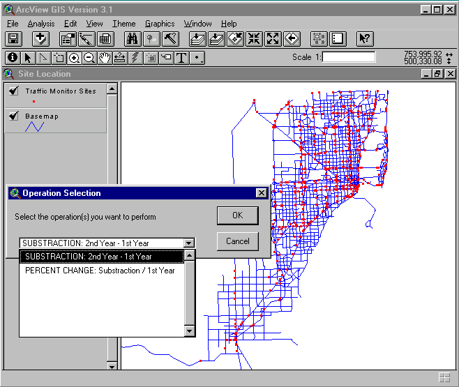
Figure 2: Analysis of change patterns of traffic count data between two years.
The above historical spatiotemporal GIS implementation represents an improvement over the snapshot GIS. With the historical data and the custom functions of analyzing changing patterns available in a GIS environment, this example demonstrates a first step toward spatiotemporal GIS that can retrieve, analyze, and display change patterns of historical transportation data. This implementation of historical spatiotemporal GIS also can be applied to many other linearly referenced transportation data that are stored in a roadway characteristics inventory database.
Urban travel demand analysis went through a major paradigm shift from trip-based approach to activity-based approach in the 1980s (Carpenter and Jones 1983, Jones, et al. 1983, Jones 1990). Conventional travel demand modeling deals with individual trips as discrete and unrelated events, while activity-based approach places an emphasis on travel activity patterns and dynamics of travel behavior (Jones et al. 1990). An individual’s daily behavior often includes a series of activities that are carried out at different locations within a time budget. Kawakami and Isobe (1990) suggest that travel-activity scheduling behavior consists of decisions on temporal dimensions (e.g., time-of-day or duration of activities), spatial dimensions (e.g., location of activities), and qualitative dimensions (e.g., types of activities or travel modes). This approach represents a significant departure from the conventional static trip-based approach that frequently aggregates trip data by traffic analysis zones (TAZs) to perform travel demand modeling. The activity-based approach requires us deal with trips at the disaggregate level and take into account the interactions between trip making activities.
A travel diary data set collected in Broward County, Florida by the Florida Department of Transportation is presented here to illustrate a method of organizing spatiotemporal travel diary data in a GIS environment (see Shaw and Wang, 2000, for details). Each trip in the travel diary data set is identified by the street addresses or the closest street intersections of its trip origin and trip destination. GIS address matching function is used to find the locations of trip origins and trip destinations on a local street network. Then, a trip path is created along the shortest path connecting its origin and destination points using the dynamic segmentation functions in Arc/Info. This creates a GIS database that maps all of the trips onto a single street network coverage for data query, analysis and display purposes. One challenge of organizing the travel diary data in a GIS environment is the handling of complex relationships among the different entities. For example, an individual often makes multiple trips, while two or more individuals could share a trip. A trip has two trip ends, but the same trip end also could be shared by multiple trips. Furthermore, many trips could start or end at the same time while each trip has its own begin time and end time. In order to facilitate query, analysis, and display of these complex relationships, this study organizes the travel diary data into four separate interrelated tables. The spatial table references trip locations through the route IDs created from the dynamic segmentation process. The temporal table records trip date, trip begin time, and trip end time. The trip makers table stores the personal information of travelers. The trip event table manages attribute data of individual trips. These tables are dynamically linked with each other through unique IDs such as trip ID and person ID. An advantage of this data organization approach is the minimization of data redundancy caused by the many-to-many relationships between the entities in a disaggregate travel diary data set. In addition, separation of spatial, temporal, and attribute data into different (but interrelated) data components provides a more flexible environment to choose the best data model for each data component. This approach follows the event-based concept proposed by Peuquet and Duan (1995).
With the spatiotemporal implementation of travel diary data discussed above, it becomes feasible to analyze travel activity patterns such as trip chaining behavior and the spatial and temporal interactions among the trips. A user can point and click any street segment to find all of the trips that used a particular street segment. The user can further issue a temporal query to limit the trips that occurred during a specific time window. Alternatively, users can analyze the travel data based on trip attributes or a combination of spatial, temporal, and attribute data. Due to the many-to-many relationships between spatial, temporal, and attribute data components implemented under this approach, a user interface is needed to facilitate the use of this spatiotemporal database for the end users. Again, Avenue scripts are developed to provide users with easy-to-use query functions based on location, time, attribute, or any combination of these three data components. Figure 3 shows one example of an temporal query that a user chooses from the custom menu option of "Trip Query" available in the ArcView user interface. The Avenue scripts process the query conditions specified by the user and then display the selected trips in both the View and the Table windows. Users also can select records in a table to highlight the related records in other linked tables and the trip locations in the View window.
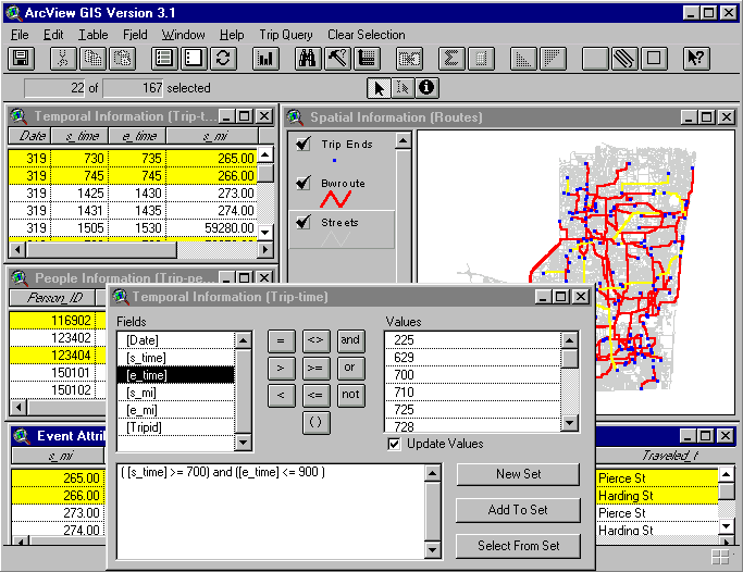
Figure 3: Spatiotemporal GIS database of travel diary data.
One major shortcoming of the above spatiotemporal implementation of travel diary data under the dynamic segmentation model is its limitation of representing the temporal data. A trip represented as a route under the dynamic segmentation model is defined by the begin time and the end time of the trip only. There is no temporal reference to the intermediate locations along the trip path. Although it is feasible to write additional scripts to interpolate the time mesures along a trip path, the peformance level will degrade significantly when a query is made to a large number of trip paths. With the wide availability of GPS today, it is relatively easy to collect (x,y) coordinates as well as the temporal data. GPS receivers automatically place a time stamp to each data record. The (x,y,t) data values collected from GPS can be used to create a point GIS map layer as an event theme in ArcView. For many transportation applications, however, we need to merge the GPS data points into a linear network GIS layer rather than handling the GPS data points as separate point GIS layers. Furthermore, it would be beneficial to transfer the time data at point locations to a linear network GIS layer such that time references could become readily available for analysis performed on the network GIS layer. One possible implementation of such a spatiotemporal GIS is to extend the distance-based dynamic segmentation into a time-based dynamic segmentation (named the temporal dynamic segmentation in this paper).
To demonstrate the implementation of temporal dynamic segmentation in Arc/Info, a GPS data set that simulates the movements of trucks on a highway network is generated. The simulated data set consists of multiple GPS files, with each file representing the weekly route of one truck. First of all, the (x,y) coordinates in each GPS file are compared against a highway network layer to retrieve the corresponding arc IDs on which the GPS data points fall. Each ordered list of the arc IDs is used to create the route of a specific truck in a given week. For the begin point, end point, and turn-back points (i.e., A truck turns back and retraces some of its previous path) along a truck route that do not match the end nodes of arcs in the Arc/Info network coverage, a procedure is developed to ensure that these points are placed at the correct locations on their respective arcs. The truck routes created from this process are organized by weeks into separate route systems. For example, the RAT table shown in Figure 4 consists of the routes operated by five different trucks in week 1. Alternatively, the route systems could be organized by trucks instead of weeks, or a single route system could be created for all trucks in all weeks. The decision of choosing a particular method of organizing the routes will depend on the application needs.
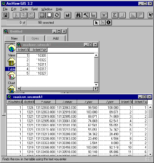
Figure 4: Temporal dynamic segmentation GIS database of simulated vehicle tracking data.
The temporal dynamic segmentation differs from the standard dynamic segmentation due to the replacement of distance measures by temporal measures along the linear routes on a network. In order to derive the time measures along each truck route, an Avenue program is developed to pre-process each GPS file such that critical GPS data points with significant changes of travel speed are extracted. These critical GPS data points are used to compute the time duration that a truck route takes to traverse each individual arc along the route. It then inserts the computed time duration data into the arc attribute table (AAT) of the network coverage. Unlike the distance-based dynamic segmentation that the same distance measure item can be used to build all routes in a route system, different routes in a temporal dynamic segmentation may take different amounts of time to traverse the same street segment if their travel speeds are different. A truck also may vary its travel speed along different sections on an arc. The section table in Figure 4 shows the varying time duration (i.e., the difference between the to-measure and the from-measure items) on the different sections (defined by the from-position and the to-position items) along an arc (e.g., Arc 1321). Consequently, time measures must be computed for each truck route and written into the AAT table before a route is created in the Arc/Info dynamic segmentation. This process is repeated for each route in a route system. For truck routes with turn-back points, the segment between the begin point and the first turn-back point along the truck route is processed first. Segments between other turn-back points and the end point are processed in a sequential order and appended to the original route to create a single continuous truck route.
Due to the repeated data processing procedures to create a temporal dynamic segmentation, scripts written in the Arc macro language (AML) are developed to automate the process. The end product of a temporal dynamic segmentation is identical to that of a standard dynamic segmentation except that the from-measure and the to-measure data items in the SEC table are referenced by time rather than by distance (see Figure 4). Users have a choice of their own temporal measurement unit (i.e., hour, minute, or second) to create a temporal dynamic segmentation; however, users cannot mix different temporal measurement units (e.g., hh:mm:ss) since Arc/Info dynamic segmentation assumes a single measurment unit to perform interpolations along a given route. The temporal dynamic segmentation implementation is built completely on the Arc/Info dynamic segmentation data model; therefore, it has access to all of the dynamic segmentation functions available in Arc/Info. For example, users can use various Arc/Info commands to display and analyze spatial and temporal relationships among different truk routes. Users also can create a linear event table by computing the geometric intersection of a polygon coverage and a temporal route system (i.e., Arc/Info POLYGONEVENTS command). In addition, an Avenue script can be added into the ArcView such that users can point and click any location on a route system to retrieve the interpolated time reference at that location. One major advantage of temporal dynamic segmentation is the integration of spatial and temporal data. While the uderlying network GIS layer is a spatially referenced database, the temporal dynamic segmentation built on top of the network GIS layer is temporally referenced. As a result, both spatial and temporal data are available to the users simultaneously for query, analysis, and display purposes.
Time is embedded in almost all geographical data. Traditionally, GIS have focused on the spatial dimension and ignored the temporal dimension. Most GIS applications therefore treat geographic data as snapshots. The snapshot approach of handling geographic data imposes major limitations to our ability of performing spatiotemporal analysis. Since the 1990s, we have seen increasing research efforts on spatiotemporal GIS. Various approaches of integrating the time dimension into GIS are proposed and studied. However, many challenging research issues remain unsolved. For example, many intelligent transportation systems (ITS) applications require capabilities of handling and modeling real-time and dynamic spatiotemporal data. Current GIS products are very weak in supporting such applications. Although comprehensive spatiotemporal data management and analysis tools might not become availabe in commercial GIS products in the near future, innovative ways of using the existing GIS products could lead to applications that include at least partial spatiotemporal query, analysis, and display capabilities.
This paper presents three different methods of incorpoarting temporal data into GIS applications using three sample transportation data sets. The first example creates a historical spatiotemporal GIS application for comparing change patterns of traffic count data between different years. This method can be applied to many other roadway characteristics that are based on a linear referencing system. The second example attempts to design a GIS database that can better integrate spatial, temporal, and attribute data components in a travel diary data set. Activity-based approach in travel demand modeling calls for better methods of analyzing travel activity patterns and the dynamics of travel behavior. The spatiotemporal database design discussed in the paper uses the dynamic segmentation model to represent the spatial domain of travel activity data. This spatial database in turn is closely linked to separate temporal database and attribute database. A custom user interface written in Avenue provides users with tools to query and display spatiotemporal travel acitivity patterns. This design also allows users to examine patterns of travel behavior such as trip chaining behavior. The third example extends the standard dynamic segmentation data model in Arc/Info into a temporal dynamic segmentation model. Instead of using a linear referencing system based on distance measures, temporal dynamic segmentation uses time measures to define each route. A simulated GPS data set of truck movements serves as an example to illustrate the process of building a temporal dynamic segmentation in Arc/Info. The temporal dynamic segmentation database created from the process has an identical structure to the standard dynamic segmentation; therefore, it can access all dynamic segmentation commands in Arc/Info to query, display, and analyze the data.
The three examples presented in this paper represent the different strategies of extending the existing GIS software to handle spatiotemporal data. It should be noted that they are developed within the contraints of current commercial GIS software. Although some custom programs are created to extend the built-in functions in Arc/Info and ArcView, the data models and functions used to build these applications are limited to those available in the Arc/Info and the ArcView. This could result in a poor performance level when large databases must be managed. Future research should explore, for example, more efficient data structures and indexing systems to link the temporal data with the spatial databases. Dynamic visualization tools such as displaying moving objects on a highway network according to a user-specified time window also need to be explored. Users should be able to adjust the display speed or freeze the dynamic display of moving objects at any select time point in order to perform spatiotemporal analysis. For example, an analysis tool could compute spatial proximity of vehicle locations to a set of customer locations at a specific time point. Another tool could compute summary statistics such as the average travel speed during a particular time window. These and other spatiotemporal display and analysis tools will make us move closer to a powerful spatiotemporal GIS.
The author would like to thank Florida Department of Transportation, District IV and District VI Planning Offices for providing the travel diary data and the historical traffic count data, respectively. Assistance from Mr. Shi-Chiang Li at the FDOT District IV Planning Office is appreciated. Special acknowledgement also goes to Mo Chatterjee, Feng Lu, David Ralston, Amy Rose, and Xiaohong Xi, who worked very hard to generate simulated GPS-based vehicle tracking data and to develop a prototype application of temporal dynamic segmentation in a transportation seminar class offered by the author in Spring 2000.
Carpenter, S. and Jones, P., 1983. Recent Advances in Travel Demand Analysis, Aldershot, UK: Gower Publishing Company.
Florida Department of Transportation (FDOT), 1996. Broward County Travel Characteristics Study, FDOT District 4 Planning Office, Fort Lauderdale, Florida, U.S.A.
Goodchild, M.F., 1998. Geographic information systems and disaggregate transportation modeling, Geographical Systems, Vol. 5(1-2), 19-44.
Goodchild, M.F., Klinkenberg, B., and Janelle, D.G., 1993. A factorial model of aggregate spatio-temporal behavior, Geographic Analysis, Vol. 4, 277-294.
Hagerstrand, T., 1970. How about people in regional science?, Papers of the Regional Science Association, Vol. 24, 7-21.
Jones, P., 1990. Developments in Dynamic and Activity-Based Approaches to Travel Analysis, Aldershot, UK: Gower Publishing Company.
Jones, P., Dix, M.C., Clarke, M.I. and Heggie, I.G., 1983. Understanding Travel Behaviour, Aldershot, UK: Gower Publishing Company.
Jones, P., Koppelman, F. and Orfeuil, J-P., 1990. Activity analysis: State-of-the-art and future directions, in P. Jones (ed.) Developments in Dynamic and Activity-Based Approaches to Travel Analysis, Aldershot, UK: Gower Publishing Company, 34-55.
Kawakami, S. and Isobe, T., 1990. Development of a one-day travel-activity scheduling model for workers, in P. Jones (ed.) Developments in Dynamic and Activity-Based Approaches to Travel Analysis, Aldershot, UK: Gower Publishing Company, 184-205.
Langran, G., 1992. Time in Geographic Information System. London, U.K.: Taylor and Francis.
Langran. G. and Chrisman, N., 1988. A framework for temporal geographic information, Cartographica, Vol. 25(3), 1-14.
Peuquet, D.J. and Duan, N., 1995. An event-based spatiotemporal data model (ESTDM) for temporal analysis of geographical data, International Journal of Geographical Information Systems, Vol. 9, 359-384.
Shaw, S.L. and Wang, D.M., 2000. Handling disaggregate spatiotemporal travel data in GIS, GeoInformatica, forthcoming.
Sinton, D.F., 1978. The inherent structure of information as a constraint to analysis: Mapped thematic data as a case study, in G. Dutton (ed.) Harvard Papers on Geographic Information Systems, Volume 6, Reading: MA: Addison-Wesley, 1-17.
Snodgrass, R.T. 1992. Temporal databases, in Frank A.U., Campari I., and Formentini U. (eds.) Theories and Methods of Spatio-Temporal Reasoning in Geographic Space. Berlin, Germany: Springer-Verlag, 22-64.
Yearsley, C.M. and Worboys, M.F., 1995. A deductive model of planar spatio-temporal objects, in P. Fisher (ed.) Innovations in GIS 2. London, UK: Taylor and Francis, 43-51.
Zeiler, M., 1999. Modeling Our World. Redlands, CA: Environmental Systems Research Institute Press.
Shih-Lung Shaw
Department of Geography
The University of Tennessee
Knoxville, TN 37996
E-mail: sshaw@utk.edu