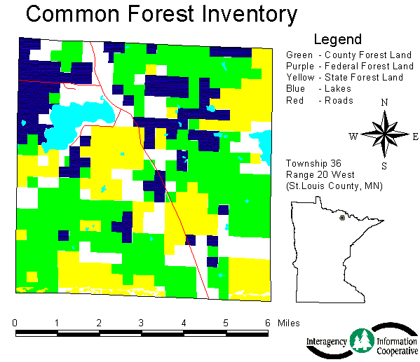
Figure 1. Map of forest inventory data, ownerships.
Forestland management agencies in Minnesota are moving toward an ecosystem management framework for managing forest resources. Ecosystem management involves planning over large areas, often looking across multiple ownership boundaries. In order to do this, forest resource data representing the entire landscape (a defined ecosystem area) is needed. Combining current forest inventory data from various forestland management groups is one method of getting data that describes forests over broad regions of the state.
Seven steps, some technical and some non-technical, were used to integrate forest inventory data from various forestland management groups:
The first step in developing an integrated database of forest resource information for Minnesota was to identify forest planners' and managers' needs for forest resource information. To do this, three workshops, involving representatives from an array of stakeholder groups, were held in late 1996 and early 1997. These meetings resulted in a list of information needs such as more detailed forest cover inventory on all forestlands, more detailed data about physical attributes of Minnesota's landscapes, and improved access to detailed stand-by-stand management plans. One broad goal that emerged from the workshops was to use this data to provide all landscape planning efforts a better picture of the forest. A final needs-assessment document titled "Interagency Information Cooperative: Forest Information Needs Assessment" was produced after these workshops; it is available on the Internet at http://www.iic.state.mn.us/about/needs.html.
Once it became clear that forest managers wanted forest inventory data from the spectrum of forestland management groups, the second step was to get permission from each group to gather and integrate their data into a common format, accessible to all other groups. In Minnesota, the key groups with forest inventory data are public agencies (county, state, and federal); all of these were willing to share their forest resource data.
The first technical aspect of this project was to look at forest inventory databases from the various forestland management groups and find the common attributes among these. This had to be done before the integrated data set could be created. In their forest inventories, all of Minnesota's public agencies had recorded stand species, stand size, stocking, stand age, year stand was measured, site index, site index species, and the level of reconnaissance. Each stand also had a unique identifier that was recorded along with the group that administered the land (Table 1).
Table 1. Common attributes of forest inventory databases.
| Item | Description |
| cover_type | Major forest type in the stand based on basal area or some derivative of basal area (i.e. volume). |
| cover_size | Average size in diameter of breast height (d.b.h.) of the cover type. |
| stocking | An indication of growing-space occupancy relative to a standard usually based on basal area or stand density. |
| age | Age of the stand at the time of the data conversion to the common inventory format. Refer to time period of content in metadata. |
| measure_year | The year the stand level data was collected. |
| site_index | A measure of actual or potential forest productivity, expressed in terms of the average height of trees included in a specific stand component (site index species). |
| site_index_species | The species of the tree from which site index was measured. |
| administrator | Manager of the stand. |
| reconnaissance level | The method used to inventory the stand. |
| stand-id | Each agencies unique stand-id. |
After the commonalties were identified, a common code was designated for each attribute. For example, the coding for cover size is shown in Table 2. The detailed table along with all the coding can be found at http://www.iic.state.mn.us/finfo/land/common/csaiictb.html.
Table 2. Coding for cover size attribute.
| Code | Description |
| 1 | 0-4.9" d.b.h. |
| 2 | 5-8.9" d.b.h. |
| 3 | 9"+ d.b.h. |
Finally, common spatial attributes were defined. The spatial attributes that were used for this GIS project include NAD83, UTM (zone 15), and meters.
Once the common attributes of the forest inventory databases from each forestland management agency were identified, each agency transferred forest resource data from their database into the integrated database. Arc macro language (amls) programs were used to create new coverages by changing the spatial characteristics, renaming the attributes, and recalculating the attribute codes. An example aml is located at http://www.iic.state.mn.us/finfo/land/common/iic.aml.
The final technical step in creating an integrated database was to take the individual databases and merge them into one complete coverage (figure 1). Due to many small differences in base data used to create the different forest inventory data sets, there is considerable misalignment between neighboring polygons. To remedy this, a region coverage was created, each layer representing a different ownership and allowing the misalignment to be handled as seen fit by the individual using the data. This solution provides the most flexibility for people to take the data, extract the pieces they need, and, if needed, merge them.
Figure 1. Map of forest inventory data, ownerships.
Once the common data set was created, the different forestland management groups participating needed to be able to get it. To make the data set accessible, the data set was posted on the Minnesota Department of Natural Resources Data Deli Internet site (http://deli.dnr.state.mn.us). This site allows anyone to download GIS data.
The final step in creating a common forest inventory data-set available to all forestland management groups was to encourage use of the common data-set to address various forest management goals (figure 2). Thus far the common data set has been used in landscape-level planning in northeastern Minnesota. It also has been used by specific agencies to help them coordinate their forest management with other agencies. There are many other possibilities for this data to be used in forest resource research and planning activities.
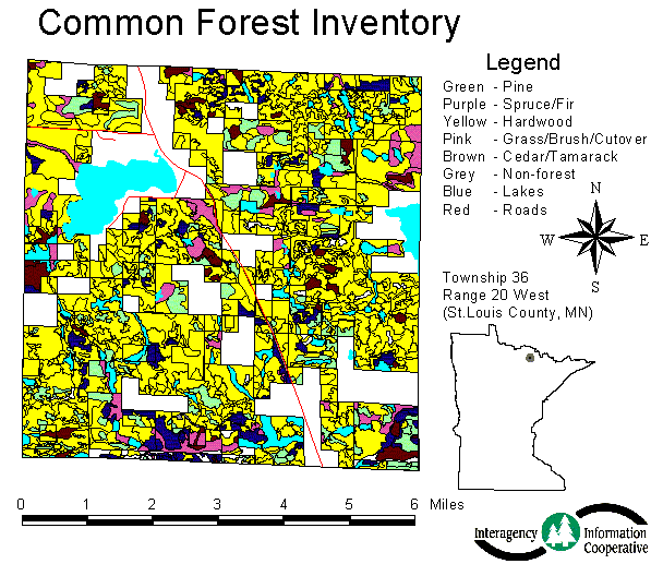
Figure 2. Map of forest inventory data, cover types.
Completing a project like this that involves many different groups takes time. The integration of forest inventory data in Minnesota is a process that involved technical and non-technical personnel, working over a two-year period. The project started in early 1997 and products were available in late 1999. This project has shown how forest resource information needs can be met. The common format forest inventory data set that was created is a tool that could not be generated by one group working independently. Collaboration, coordination, interagency information, multiple ownership planning, landscape-level planning, ecosystem planning-all of these are required to make a project such as this possible.
Minnesota Forest Resources Council, Interagency Information Cooperative, Minnesota Department of Natural Resources, Superior and Chippewa National Forests, and Minnesota Association of County Land Commissioners, University of Minnesota, Pro-West and Associates Inc.