Christopher Eckstein
Management Strategies: Ensuring a Smooth Transition from Implementation to Operational Status
The Grand River Conservation Authority is a watershed management agency representing the joint interests of 44 municipalities in the Grand River Watershed, the largest in Southern Ontario, Canada. In 1995, our agency invested in GIS technology as part of a major re-engineering process to improve data and information management activities. Implementing GIS technology into an organisation is only half the challenge. Making it operational and sustainable requires strategic planning and foresight. This paper, and accompanying presentation, addresses a series of management strategies that other agencies may find beneficial to ensure a smooth transition from implementation to operational GIS status.
Introduction
The Grand River Conservation Authority is a watershed management agency representing the joint interests of 44 municipalities in the Grand River Watershed, the largest in Southern Ontario, Canada. In 1995, this agency invested in GIS technology as part of a major re-engineering process to improve data and information management activities. Implementing GIS technology into an organisation is only half the challenge. Making it operational and sustainable requires strategic planning and foresight. This paper, and accompanying presentation, addresses a series of management strategies that other agencies may find beneficial to ensure a smooth transition from implementation to operational GIS status.
Geographic Context
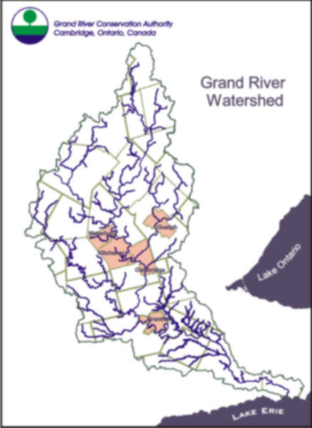
The Grand River Watershed is located west of the City of Toronto. It sustains a population of over 700,000 people living in 34 municipalities and 10 regions and counties. The Grand River Watershed is the largest in Southern Ontario and the Grand River Conservation Authority has significant and varied responsibility for resource management related to the basin as a whole. Our administrative area is the watershed boundary and not the more typical political boundary (see Figure 1 and 2). The watershed or drainage area of the Grand is 6,800 square kilometres (2,600 square miles).
Figures 1. Geographic Context
This watershed is drained by the Grand River, its main tributaries the Speed, Eramosa, Nith, and Conestogo rivers as well as hundreds of other tributaries. The Grand River begins north of Dundalk, 40 kilometres (25 miles) south of Georgian Bay, and drains into Lake Erie at Port Maitland, and is the largest river system entering the lake. The Grand River is 298 kilometres (185 miles) in length, and water falls 352 metres (1161 feet) from the headwaters to Lake Erie. Historically, culturally, and ecologically the Grand River watershed represents one of the richest and most diverse areas in Canada.
Today, the Grand River is central to tourism and recreation. It sustains water quality and water supply for the largest concentration of inland population living anywhere in Ontario. It remains central to the health and future economic viability of municipalities in the Grand River valley.
Business of Watershed Management
Our organisation is one of thirty-eight Conservation Authorities and represents a partnership between watershed member municipalities and the Province of Ontario. The Grand River Conservation Authority (GRCA) was formed in 1966 upon amalgamation of the original Grand River Conservation Commission (1934) and the Grand Valley Conservation Authority (1948). Enabling legislation is the Conservation Authorities Act of Ontario. In terms of staff, the GRCA has approximately 100 professional and technical people that possess a wide range of competencies.
Similar to municipalities, Conservation Authorities range in geographic size and range of programs and services. In general, watershed management involves: watershed planning, improving water quality, reducing flood and erosion damages, protecting natural areas and biodiversity, ensuring water supply, information management, and environmental education and public awareness. The GRCA offers a wide-range of programs and services and funding comes from provincial government grants (9%), municipal taxes (30%), and self-generated revenues (61%).
Implementating and Integrating GIS Technology
In 1995, the GRCA began the process of implementing GIS technology as part of a major re-engineering process to improve data and information management activities. Using the expertise of a professional and experience gained from other site implementations, the GRCA's goal was to ensure a successful implementation, in a timely manner. To do this, we needed to ensure GIS was an integrated part of the business.
To expedite the changes in business (both organisationally and functionally), a GIS implementation Plan was formulated. The purposes of the GIS Implementation Plan were to identify issues and provide strategic directions for senior management endorsement. The Implementation Plan identified business drivers, a principle goal and objective, an implementation/integration approach, and specified a series of guiding management strategies and associated principles. Once the Implementation Plan was developed efforts began towards the development of a work plan of activities. The work plan identified priorities and deadlines for specific corporate initiatives which were adjusted yearly based on a consensus approach.
Business Drivers of Implementation
At the Grand River Conservation Authority, GIS implementation was driven by a number of business needs. The business needs are summarised as follows:
- The need to improve the level of service provided to watershed partners and the public
- The need to reduce costs
- The need for better co-ordination and management of (internal and external) functional interdependencies, and
- The need to address competitive pressures
Goal and Objective
Our goal of GIS implementation was deliver an integrated, watershed-based GIS for resource management that meets the evolving needs of the Grand River Conservation Authority and its partners. Our objective was improved business performance.
Approach
The Implementation Plan called for the formation of an implementation team. The team consisted of all functional managers along with Information Systems personnel. Such a team had never before been pulled together within the organisation. This presented the first of many challenges since each division of the organisation tended to act somewhat independently. However, in order for the implementation to be successful and for consensus on implementation priorities to exist, each manager needed to know and understand the business pressures being faced by other managers across each of the organisation's divisions. Although it was important to know and understand what each manger wanted, the implementation of GIS technology at the GRCA was a corporate initiative and therefore had to reflect what the organisation needed as a whole.
Guiding Strategies
The bulk of the Implementation Plan consisted of strategies and accompanying principles dealing with three critical components - human resources, technology, and information. The human resources component outlined communication principles as well as training and education principles. The technology strategy contained principles for dealing with operational and financial matters. The information component dealt with data and application principles.
Management Strategies
Implementing GIS technology into an organisation is only half the challenge. Making it operational and sustainable requires strategic planning and foresight. Having a well-thought out and established Implementation Plan that goes beyond simply implementation issues provides a foundation for ensuring an operational and sustainable GIS operation.
What is a strategy? A strategy is a plan or technique for achieving some end. In our case, we were working towards a clearly defined business goal and objective. However, to implement and integrate GIS so that this technology becomes operational and sustainable required establishing management strategies, each composed of a series of principles. These principles or rules of conduct that the organisation had to adopt and adhere to were essential to achieving success. Although some may seem like common sense, often these represent fundamental organisational and functional shifts that require significant effort. The payback is often not noticeable until further down the road.
To ensure a smooth transition from implementation to operational status, a GIS implementation plan must contain management strategies that deal with human resources, technology and information. The accompanying presentation presents a series of management strategies, and associated operating principles, the GRCA has followed to ensure a smooth transition from implementation to operational status.
Conclusions
To fulfil its vision and mandate our organisation employs GIS technology throughout its business operations. Implementing GIS technology into an organisation is only half the challenge. Making it operational and sustainable requires strategic planning and foresight. This paper provides a context for our discussion. The accompanying presentation addresses a series of management strategies that other agencies may find beneficial to ensure a smooth transition from implementation to operational GIS status.
Christopher Eckstein
Geomatics Co-ordinator
Grand River Conservation Authority
400 Clyde Road, P.O. Box 729
Cambridge, Ontario, Canada
N1R 5W6
Telephone : (519) 621-2761
Fax : (519) 621-4844
Email : ceckstein@grandriver.on.ca