Carl Yetter
Development of Delaware's Coastal Zone Environmental Indicators Decision Support System
Abstract:
A Delaware Coastal Zone Environmental Indicators (CZEI) Decision Support System is utilized to provide a common method of assessment and a standard method of data analysis. It consists of databases linked to a GIS. The System uses GIS to create standard functions with specific environmental parameters. Frequency distribution analysis is used for the purpose of presenting the status of an indicator. The data for the indicators project is organized by grid cell. CZEI will better inform Delaware of the health of the Coastal Zone and consequently will allow for more scrutiny in examining management efforts.
Delaware's Coastal Zone Environmental Indicators Initiative
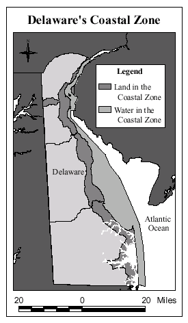
Delaware's Coastal Zone is a strip of land, water and subaqueous areas approximately 4-miles wide that borders the shoreline of the entire state. The state's most important and fragile coastal resources are located in this area, as well as the majority of Delaware's heavy industry. In the interest of protecting coastal resources, new heavy industry facilities and bulk production transfer are prohibited in this area and changes to existing facilities and new manufacturing activities are subject to a permitting process. The development of environmental indicators for Delaware's Coastal Zone will provide much needed information for making reasonable and consistent permitting and offset project decisions within this area and will yield a tool for measuring coastal environmental health. Coastal Zone environmental indicators also have the potential to be expanded upon for use in statewide planning and statewide permitting decisions. This document provides background information and outlines the proposed framework for developing a set of environmental indicators for Delaware's Coastal Zone.
History of Delaware's Coastal Zone Act
Delaware's General Assembly adopted the Delaware Coastal Zone Act (CZA) of 1971 as a means to control the location, extent, and type of industrial development in Delaware's environmentally sensitive Coastal Zone. The development of a set of regulations was required as a component of this act; however, a lack of agreement over content kept them from being promulgated for over 25 years. In 1996, the Coastal Zone Regulatory Advisory Committee was established to develop a set of CZA Regulations. This committee ratified a Memorandum of Understanding (MOU) after 18 months of consensus building efforts. The MOU formed the basis for Delaware's Coastal Zone regulations.
The CZA regulations, formally adopted in May 1999, were created to ensure environmental improvement in the Coastal Zone while allowing industry the flexibility to remain competitive. In order to balance these two long-term goals, the Delaware Department of Environmental Control (DNREC) has been directed to develop tools that will help to assess the health of Delaware's Coastal Zone. One critical tool needed for these assessments is a set of Environmental Indicators (EI) specifically targeted towards the Coastal Zone. The EIs will assist in assessing the health of the Coastal Zone and in tracking the progress towards Coastal Zone goals (listed below).
In order to develop goals and environmental indicators for the Coastal Zone, DNREC brought together interested representatives from various stakeholder groups to form the Environmental Indicators Technical Advisory Committee (EITAC). Thus far, the EITAC has developed four broad goals, outlined 14 prioritized environmental indicators with a list of 47 spatial parameters, and evaluated the implementation potential of each indicator.
Purpose of Delaware's Environmental Indicators Initiative
The goal of Delaware's Environmental Indicators Initiative is to develop a means to measure, monitor, and report on the health of the coastal area for the purposes of permitting and assigning offset projects for heavy industry located within the Coastal Zone. The driving force behind this effort to date has been the statutory requirement to produce indicators, but the usefulness of the indicators initiative has the potential to greatly exceed the initial purpose.
Environmental indicators will better inform DNREC as to the health of the Coastal Zone and consequently will allow for more scrutiny in examining state and local management efforts. Such information will be useful in future resource allocation decisions and can help identify potential environmental problems before they become crises. This initiative will also help to achieve DNREC's objective to integrate environmental data. The collaboration required across many parts of government, industry, and others for this project to be successful lays a foundation for continued cooperation in promoting a more efficient and effective method of environmental management.
In addition to informing responsible officials in government, data will also be made available to the public as part of the "State of the Coast" bi-annual report. As the ultimate benefactors of a healthy environment, the citizens of the state of Delaware have a very direct stake in their coast's well being and have expressed an ongoing interest in its continued vitality. Commercial, recreational, and everyday users of the coast expect their government to make them aware of environmental concerns in the Coastal Zone and to highlight where progress is being made towards environmental improvement.
A purpose that extends beyond the state of Delaware is the interest in establishing a national framework for gauging the environmental health of the nation's coastal zone. The system proposed for Delaware may have some of the elements that would be desirable in such a national perspective - consistent geographic units, a reasonable number of indicators, and a means of synthesizing and reporting results. The involvement of the National Oceanic and Atmospheric Administration (NOAA) in this effort stems from the project's potential benefit to our national perspective.
What are Environmental Indicators?
An indicator is a summary index of several related parameters. Environmental indicators for Delaware's Coastal Zone will be broad-based representations of coastal environmental health for each of the EITAC goals. Several indicators will be developed for evaluations and assessments of each goal. Each indicator will be comprised of several quantifiable parameters. The Air Quality goal, for example, might include four separate indicators: ambient air quality; affected populations; accidental releases and spills; and atmospheric deposition. The atmospheric deposition indicator would be derived from four parameters: atmospheric deposition of nitrate (NO3), atmospheric deposition of ammonium (NH4), atmospheric deposition of sulfate (SO4), and precipitation pH.
Data Compilation, Collection and Management
The Environmental Indicators Initiative will utilize existing and/or historical federal, state, and local data to the maximum extent possible. Because of the prohibitive costs of obtaining new data, the availability of existing data may determine initial indicator selection. Existing or historical data used in this initiative must be acceptable in terms of methods and procedures, and must be available at suitable spatial and temporal scales.
Information and data will have to be collected for selected parameters. As a result, new measurement or monitoring activities will be initiated for indicators identified as high priorities by EITAC. These activities will provide information at sufficient temporal and spatial scales to meet the objectives of the Environmental Indicators Initiative.
A group of experts from various private, governmental and non-profit organizations will determine the temporal frequency and spatial resolution of monitoring at a series of focus group meetings. At these meetings, the parameters that comprise the indicators will be evaluated and refined. In addition, procedures for data collection will be defined.
A direct outgrowth of the Environmental Indicators Initiative will be improved coordination between institutions that conduct environmental monitoring in Delaware. If appropriate and reasonable, monitoring and measurement activities conducted by government agencies, academia, and private non-profit organizations will be integrated. This will enhance the project significantly since it will provide for a more comprehensive suite of indicators. There is insufficient funding for the state to implement monitoring programs for the 47 parameters identified to date. The only reasonable solution is to integrate existing monitored data into the EI program.
How Will the Indicators Be Used?
An Environmental Indicators Decision Support System will be created to provide a common method of access and a standard method of data analysis for decision-makers and support staff. It will consist of databases linked to a desktop Geographic Information System (GIS). The Decision Support System will use GIS to create standard functions with specific environmental parameters. For example, an environmental offset proposal for wetland creation to mitigate for water quality degradation in a watershed might not receive approval if the wetland would not filter proposed chemical releases to ambient levels within the watershed. The Information Decision Support System would allow a user to model the size and function of the proposed wetland and compare its filtering potential directly to the ambient water quality data in a database.
Frequency distribution analysis will be used for the purpose of presenting the status of an individual indicator. For example, a chart could be developed that shows the distribution of watersheds within the state for a specific water quality parameter (e.g., dissolved oxygen). The chart would depict watersheds with values that fall above and below the mean values for dissolved oxygen in the state (see below). This information would allow users to determine where a particular watershed ranked among all watersheds in the state for dissolved oxygen levels. It would also reveal if trends in the watershed's dissolved oxygen level place it among improving or declining watersheds.
Spatial Framework of Indicators
The spatial framework should be detailed enough to provide information useful for funding allocation, permitting, and offset project decisions. The data for the indicators project will be organized by grid cell. The project team will conduct detailed evaluations for the optimal cell sizes. It is anticipated that the cells will be 1-5 km on edge. It will also be possible to aggregate the grid cells into larger units. The watersheds and other summary units should be at a scale that provides information at sufficient detail to make summaries of the status and trends of Delaware's Coastal Zone.
The following diagram illustrates the process that we envision for developing and using spatial information to create indicators. The section following describes sections of the illustration in terms of project tasks.
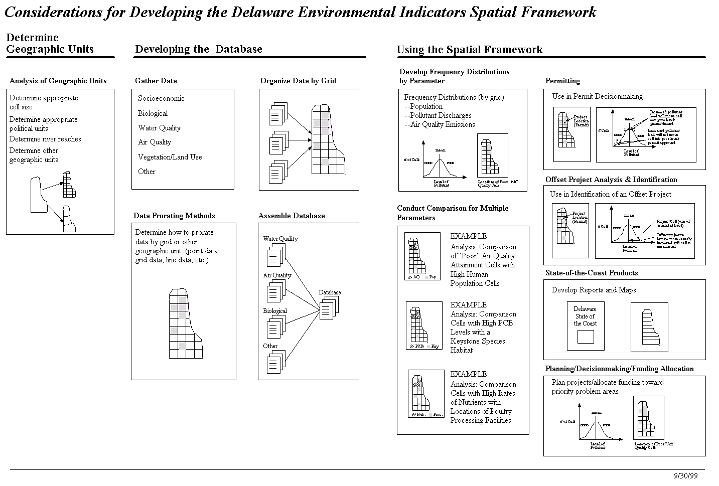
Click here for full size chart.
Determine Geographic Units
Setting up the systems units of analysis has been a key discussion point in the formation of the project. Whether to use a fixed grid system, variable grid, or natural features such as watersheds will play an important role in the usability of the system. As refinement is done on what datasets the indicators will be based on limitations of the various methods of aggregation have come out. Particular problems include accounting for river reaches and determining the spatial coverage of limited sampling points (how far does the data "stretch" before it breaks?).
Currently the groups thinking is to use a variable but concentric grid where more detailed grids are evenly divided into the larger, more coarse grids.
Developing the Database
This will be the real legwork of the project. The work of identifying needed datasets is ongoing. Focus Groups centered on each Coastal Zone Goal are developing specific measurements to monitor environmental health. After a data layer is selected, the key question becomes how to prorate or score that measurement into the grid system. This becomes somewhat of a looped process with the previous section on setting the grid size. Of particular concern to the project group is how to score water samples. The sample represents conditions within a reach of the stream. Does this then become the score for all water in that grid cell?
Assembling the database is a task that will depend on close coordination with the Department's IRM staff. Monitoring and status data is collected and stored at various places in DNREC. IRM staff are currently working to standardize and consolidate this hodge-podge of data. Until larger department efforts bear fruit, it will be necessary to create a local database that brings all of these pieces together. As data from the Department becomes centralized the decision support system can take advantage of data on the network.
Using the Spatial Framework
Two mandates came from the new Coastal Zone Act Regulations. The first was that the indicators, and thus the spatial framework that supports them, must track the overall health of the coastal zone. Second, these indicators must be able to provide input to the permitting and offsetting process.
The decision support system plans to utilize frequency distributions to characterize the status of areas throughout the State. By graphing the number of "good" or "poor" grid cells throughout the state will allow comparison among the cells. Important to note on the distribution will be the ecological or regulator breakpoint. That is the measure that separates good from poor. Obviously the goal is to have all of the cells on the "good" side of the breakpoint. Those cells below the breakpoint then become the targets for increased attention.
As mandated by the Regulations a biennial "State of the Coast Report" is to be produced. A statewide grid scoring system coupled with the frequency analysis should provide more than adequate support to this effort. Again looking back to the first section, Geographic Units, if the cells are sized properly, they can be aggregated to larger areas that the general public and legislators may find more meaningful, such as watersheds or hundreds. Grid cells can also be mapped to form a continuous surface. When mapped with base layers, these maps can be both informative and visually pleasing.
Conclusion - Current Status
The project is currently looping through the Geographic Units and Database Development Phases. The outcome of the initial Environmental Indicators Technical Advisory Committee has identified those issues and areas of the environment that should be measured and tracked. What is needed is to further refine this work by defining the specific methods and measurements to be used. In many instances this is simply documenting and compiling the data from existing monitoring. In other cases, new monitoring programs will need to be developed. This refinement is being done by Focus Groups centered on the four Coastal Zone Goal areas: Air Quality, Water Quality, Habitat and Land Cover, and Living Resources. The Focus Groups are charged with specifying the methods of evaluation and setting the "breakpoints."
The methods and measurements will determine the data that needs to be collected and incorporated into the Decision Support System. Once an initial set of indicators is functioning, work with the permit evaluation group can begin to develop and refine the final user interface.
Acknowledgments
The authors would like to thank Tim Goodspeed, Tom Culliton, Mark Jacobsen, Robert Aguirre, and Karen Earwaker of the Special Projects Office, National Ocean Service, National Oceanic and Atmospheric Administration, for their hard work and cooperation.
Carl Yetter
Environmental Engineer III
David Carter
Environmental Program Manager II
Robert Scarborough, Ph. D.
Environmental Scientist IV
Delaware Coastal Programs
Department of Natural Resources and Environmental Control
Dover, DE