Title Creating and Maintaining a Fire Resources Atlas Using GIS
Phil Beilin, Scott Hill, Ayako English, Steve AbborsAbstract
East Bay Municipal Utility District Natural Resource Department has used Arc-Info and ArcView GIS to create a GIS database of fire resource data layers. These layers include: the location, type, and status of fire roads and fire abatements; seasonal fuel hazard rating; and modeled fire severity. This database is used to maintain and assess the potential wildland fire condition of this watershed area. A number of the layers have been combined into a fire atlas product for use by fire agencies responding to incidents in this area. The map atlas was created using ArcView GIS 3.2. This product was displayed at the Diablo FireSafe Council users group (for fire agencies within Alameda and Contra Costa counties) and has led to the formation of a GIS subgroup that is actively compiling its own fire resource data. This information is intended to be shared among agencies and eventually put into a Web-based GIS fire atlas for use in fire response.
Introduction
This paper will discuss the use and direction of GIS, by the East Bay Municipal Utility District (EBMUD), Natural Resource Department (NRD), in its fire management program. EBMUD is a public water service provider in the San Francisco East Bay Area of California. Its local reservoirs are surrounded by approximately 28,000 acres of protected watershed land. Part of this watershed land, is adjacent to the area impacted by the disastrous Oakland Hill’s Fire of 1991. The District has been using GIS to help manage and assess its fire management program for about four years. A Fire Management Plan has been developed, in which much of the management and analysis is supported by GIS. A subsequent Fire Atlas has been finished and is currently being distributed to neighboring fire response agencies. Aspects of the GIS layers and their management will be discussed.
The District is also an active participant and supporter of the Diablo Firesafe Council (Contra Costa and Alameda Counties), a member of the State FireSafe Council. NRD GIS staff has helped implement a GIS/Web subgroup for this consortium of fire response/management stakeholders. This activity has significantly sparked an atmosphere of cooperation and data sharing among many of the member agencies. The second part of this paper will describe some of these activities and their direction.
GIS data layers
GIS layers for the Fire Management Program were designed to meet several objectives. One was to be able to manage and maintain information about the various fire mitigation and abatement operations throughout the watershed. Another objective was to summarize information that could be used to protect sensitive species, preserve biodiversity and protect water quality and the integrity of the reservoirs. Finally, it was envisioned that certain GIS layers could be put together into a Fire Atlas. This would be especially useful for the mutual aid responders who are not familiar with EBMUD’s watershed lands.
One can see from the fire management objectives that a multi-disciplinary GIS structure is really necessary to compile these various types of data. In fact, a number of the programs/divisions within the Natural Resources Department, maintain specific GIS layers, such as the grazing, fire management, trails, and wildlife programs. All these programs contribute data to an easily accessible centralized NRD GIS data server. The cumulative data from these efforts can then be realized by many. The data is developed and maintained using a combination of both Arc/Info and Arc/View software.
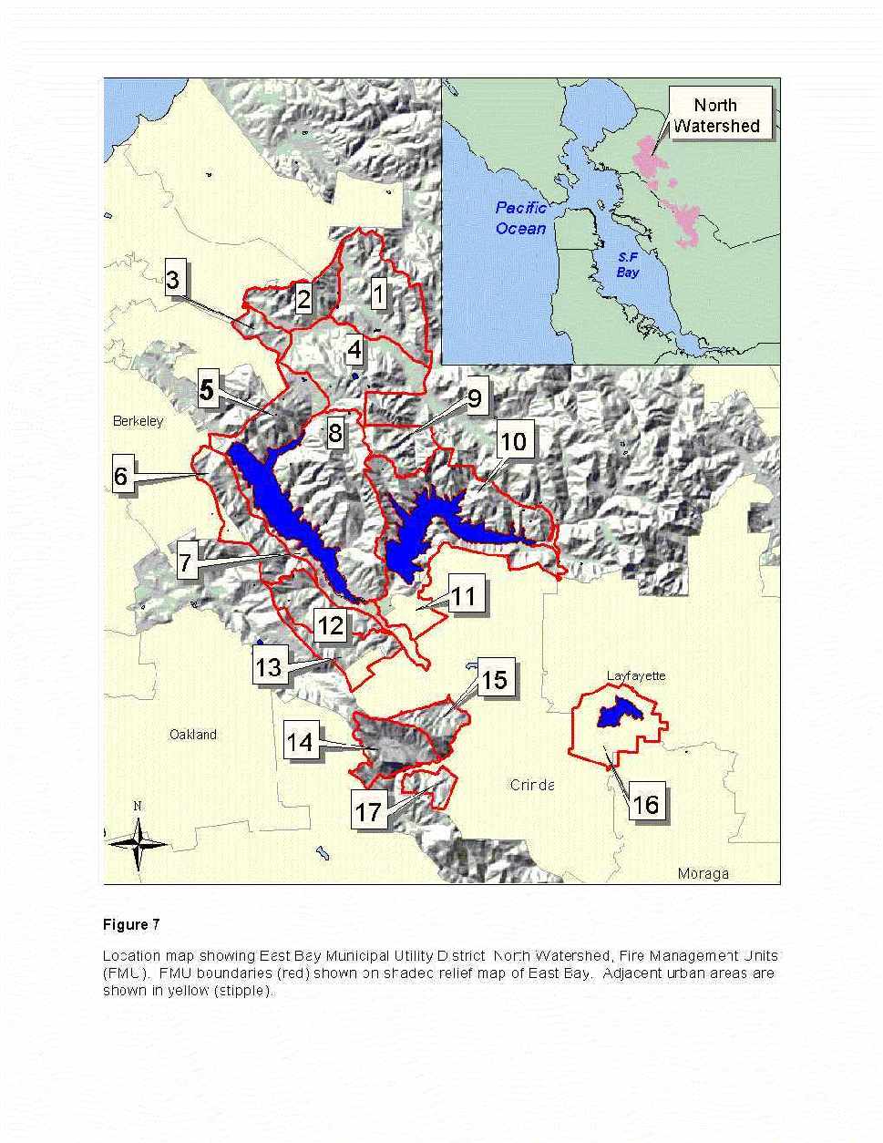
Several types of GIS layers were created to support fire. The primary themes are infrastructure (roads, water sources, gates); fire hazard, fire risk (history of incidents); abatement areas (disking, grazing, thinning, horse logging); areas of biological concern; areas to protect for water quality reasons (areas of high erosion, proximity to reservoir); strategic fuel-breaks (green lines, fire management units (fmu). By looking at the business needs and maintenance issues of the various NRD groups, custodians were identified for the individual data sets. Specific database design and GIS structure issues were created to meet the needs of the various groups. For example, the roads GIS layer is stored as a combination of public access roads, fire roads (District) and hiking trails.
Attributes are used to differentiate the various types of roads and their function. This enables the fire management group to show its fire roads and the trails group to manage their trail system. Abatement activities, such as disking, are regularly evaluated to assess their effectiveness and impact on the landscape. For this reason some of the datasets are annually archived to enable this kind of assessment. Other datasets, where the area does not change, and in which abatement activities are performed every couple years have associated look-up tables (one to many relationships), which indicate the year the particular abatement method was performed.
These data sets are used in a variety of ways to help support the fire program. The most obvious is to enable management to quickly assess the status of various activities leading to the desired levels of fire abatement and mitigation in the course of the fire season. The timing of these activities are coordinated with the aid of various layers of GIS data that indicate the various temporal constraints or windows of opportunity. For example, the grazing schedule is modified to minimize impacts of sensitive species or timed to coincide with dryer times of years to minimize erosion and potential water quality problems.
The second major area of use of this GIS data is to share with surrounding fire response agencies. This has multiple benefits. It allows these agencies to see the abatement measures on watershed land that border the areas of their land. A combination of suburban/urban areas and other large tracts of publicly-owned openspace surround the EBMUD watershed lands. These other areas all have fire mitigation programs of their own. They can take a more regional look at their fire prevention strategies by using the NRD fire resource GIS datasets. In addition, when mutual aid is envoked it is extremely helpful to have already provided responding agencies with useful access and pre-attack planning information. By having this data in advance of an actual fire, responding agencies will be well-informed and better able to help EBMUD suppress the fire and minimize resource damage. Much of this information is in the fire atlas. This product is intended to be widely distributed to surrounding agencies, to give them a better understanding of the fire resources and fire-fighting constraints on watershed land. One measure of success for this objective will be the number of fire response vehicles that carry this atlas. Exchange of fire resource and severity information also occurs by sharing the actual GIS data sets and during meetings on watershed lands to review the abatement areas with surrounding agencies.
The Fire Atlas Format
The fire atlas was designed to give responding agencies an annual picture of the road access, environmental and topographic constraints and fire hazard severity. A two- page format was chosen. The atlas was designed completely in Arc/View version 3.2. The watershed land was divided into 33 fire managament units (figure 1). Each pair of pages illustrates one or two fire management units. One page shows modeled fire severity data for normal fire season weather (typically June – August) and late fire season weather (typically September – October) (figure 2). In this area of California, the late season, hot, easterly Diablo winds often lower humidity to dangerous levels. This condition combined with areas of dry fuel and well-traveled roads create high and extreme fire hazard conditions. This page clearly shows the high hazard areas on an ortho-photo base. The facing map page (figure 3) is primarily a locational map. It shows a larger view of the same area, also with an orthophoto base.
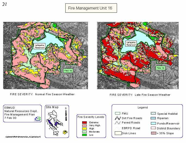
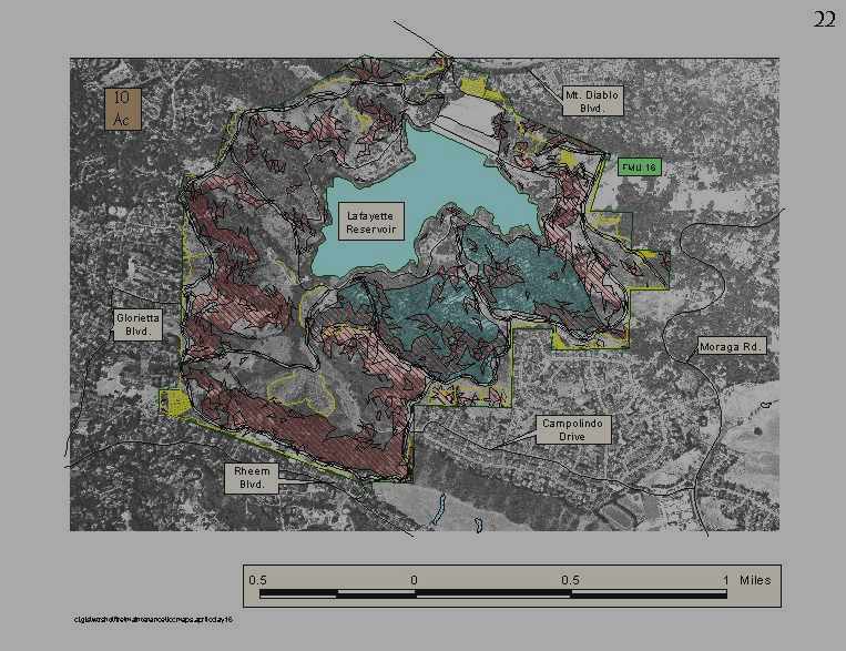
Environmental and topographic constraint information was added by displaying riparian and special habitat areas, disk lines, ponds/reservoirs and areas of greater than 35% slope. The information was symbolized in a way to minimize conflict with the user’s ability to see the underlying ortho-photography. Both pages show existing road access and the strategic fire management unit boundaries. These atlas pages are also organized on the District’s internal web site.
Future Atlas Direction
Most of the processes to schedule updating of NRD’s fire resource information have been implemented. Additional data such as gate numbers and available water sources will be added to the next version of the atlas. The primary benefit of the atlas data will be its integration among surrounding agencies. To this end, continued efforts will be made to share data and GIS resources with surrounding response agencies. The District will work with the other agencies to acquire their fire abatement and fire hazard data for incorporation in this fire management program. This is just the first phase in the evolution of this fire atlas. A much-expanded version of this atlas is envisioned.
The Diablo FireSafe GIS sub-group is planning to compile a seamless fire resources GIS database for the two county area (Alameda and Contra Costa counties). It is anticipated that this compilation will be housed in a data server with initial web access to member fire response/emergency management agencies. The web site will also be enabled to provide agencies a means to down-load GIS data sets. A fire atlas-like interface will be provided through Map Objects or Arc/IMS to provide agencies updates of atlas pages. An associated metadata document will help to ensure that users will be aware of the level of accuracy and currency of the data. Effort will be made to develop and promote and standardize existing fire standards, symbols and categories for fire management data. It is recognized that some of the data layers will be at various scales and in different levels of completeness. The use of GPS is growing rapidly in a number of local fire response agencies. This will add significantly to the spatial accuracy of some of the data layers.
The latest Diablo FireSafe meeting focused on the use of GIS for fire response and planning and the use of ruggedized, touch screen laptops for emergency response. The meeting generated significant interest in the audience. It was suggested at the meeting that the laptop applications should minimize the data they receive and transmit. It is planned that the compiled fire resource GIS datasets will be available for use in GIS applications used on these vehicles.
Conclusions:
Managers and staff of the EBMUD, Natural Resources Department are pleased with the usefulness of GIS to manage and analyze data to support its fire management program. A plan is in place for the timely updating of the GIS data layers to assess the status of fire abatement activities. The data has been incorporated into a Fire Response Atlas and is in the process of being distributed to adjacent fire response agencies. Staff is working with the Diablo Firesafe Council to create a more regional set of GIS data layers in Alameda and Contra Costa counties. It is planned that these compiled data layers will be accessible to the fire response and emergency management agencies through a fire atlas-like web interface. The Council’s GIS subgroup is also planning how to locally implement touch screen laptops with GIS enabled applications for use in fire response.
Acknowledgements
Reza Ghezelbash, Geohydromatics, Inc created all the original fire fuel and fire severity modeled GIS data and a number of the fire resource GIS data layers. Ayako English currently performs most of the GIS fire resource updates.
Authors Information:
Phil Beilin, GIS AnalystOrganization: East Bay Municipal Utility District, Natural Resources Department
Address: 500 San Pablo Dam Rd,
Orinda, CA 94563 USA
Phone: (510) 986-7640
Fax: (925) 254 8320
Email: pbeilin@ebmud.com