SKAGIT ESTUARY
RESTORATION ASSESSMENT
Identifying and prioritizing areas for habitat restoration in Puget Sound's largest rural estuary
By
Tom Dean, Zach Ferdaña, Jacques White
People for Puget Sound
Curtis Tanner
U.S. Fish & Wildlife Service


Pacific Coast Joint Venture
Spurred by proposed Endangered Species Act listings of Puget Sound salmon and other marine species, we developed a GIS site selection tool to identify and prioritize restoration and conservation targets throughout the Sound. For the Restoration Blueprints, we used ARC GRID and ArcView to create a coincidence model based on historic tidal influence, seasonal and tidal flooding, hydrologic zones, ecological sustainability, land use and land cover, and parcel density. These criteria are based on principles of landscape ecology and ease of restoration. This analysis for the Skagit Estuary could be applied to any rural delta in the Puget Sound/Georgia basin.
Table of Contents
- Purpose of this Study
- Chinook Salmon and the Skagit Estuary
- The Loss of Habitat in the Skagit Estuary
- Prioritizing Areas for Estuarine Restoration
- Discussion
- Appendix
- Data Limitations
- Acknowledgments
- Bibliography
Purpose of this Study
The sub-estuaries of Puget Sound - the major river deltas - have suffered a collective 80% loss of tidal marsh habitats in the past 150 years. In order to restore balance, function and health to our ecosystem and natural resources, People for Puget Sound is looking for opportunities to reverse this loss by restoring salt marsh and other estuarine intertidal habitats.
This study has two goals. The first is to identify the extent of habitat loss in the Skagit River estuary. The second is to identify and prioritize areas that would be appropriate for restoring estuarine habitat.
This study is not a restoration plan, but rather the ecological basis for developing a restoration plan. Any restoration plan will have to combine this assessment with social, cultural and economic values and activities in the Skagit River delta and drainage. Development of a delta restoration plan can best be accomplished through coordination and adoption by an open, community-based organization like the Skagit Watershed Council.
Through this study, we have developed a simple system of looking at the physical landscape to sensibly prioritize restoration goals based on the historic estuary. We designed this system with the ultimate goal of applying it to all rural river deltas in the Puget Sound basin.
While restoration of Puget Sound's estuaries is essential for the survival of chinook and other wild salmon, it also provides myriad benefits for birds and wildlife as well as for human recreation and enjoyment of nature. In addition to improving opportunities to catch fish and hunt or view wildlife, restored tidal wetlands provide areas for flood waters to disperse. Various programs and tax laws can provide financial incentives for landowners to engage in restoration of the historic estuary.
Chinook Salmon and the Skagit Estuary
The Skagit River and its drainage basin encompass a rich history of natural processes and human development. From its headwaters in the North Cascade range to its extensive delta in Skagit County, the Skagit watershed is the largest that drains to Puget Sound. The Skagit was once home to one of the largest runs of wild chinook salmon in Puget Sound, with thousands of fish returning each year, but by 1999 the number of returning wild spawning spring chinook had dropped to 471 fish (Pacific Fishery Management Council, 2000.)
Intensive land modification, primarily logging and draining of lowlands for agriculture, began around 1860 (Beechie et al., 1994). The Skagit River delta was one of the first in Puget Sound to be converted from tidal wetlands to agriculture. A vast and densely vegetated wetland, including a complex system of channels and sloughs extending from the shoreline into the upland forest, was cleared and drained. This made the delta inaccessible or inhospitable to the fish and wildlife that had adapted to those habitats over many centuries.
One animal that relies heavily on estuarine habitat is the chinook salmon, Oncorhynchus tshawytscha. In March of 1999, the National Marine Fisheries Service (NMFS) listed Puget Sound chinook as "threatened" under the Endangered Species Act. Many factors have contributed to the decline of Puget Sound chinook, including over-harvest, competition from hatchery fish, water quality degradation, and habitat loss. Research conducted by fisheries scientists in the Skagit delta and elsewhere (Aitkin, 1998) shows that estuarine habitat is extremely important in the life cycle of wild chinook salmon, and that the lack of this habitat may limit the ability of those stocks to recover to harvestable levels.
Specific anadromous fish (fish that migrate from fresh water to salt water and back again) use specific portions of the estuary for various spans of time (Healey, 1982; Simenstad et al., 1982). Several species stop in the estuary as juveniles to feed and gather strength for their ocean journey. Their primary food source are insects or small aquatic invertebrates that feed on live or decaying marsh vegetation (Healey, 1982). Most anadromous fish use the heavily vegetated side channels and blind (dead-end) sloughs of a healthy estuary to escape predators and acclimate to salt water (Simenstad et al., 1982). When estuaries are levied and diked, juveniles are forced into main channels where water is deep, currents are strong, food is scarce, and predators can easily find them.
Chinook salmon have a complex life history, and display wide variations in the timing of their migration and residence in different parts of the Skagit River system. There are, however, two general types of migration patterns in chinook salmon - stream-type and ocean-type. Chinook salmon that spend their first year of life in the river are called stream-type. Chinook salmon that migrate into marine waters (Puget Sound) during their first year of life are called ocean-type. Ocean-type chinook swim down to the estuary as juveniles (up to six months old) where they stop to feed for anywhere from six to 189 days (Simenstad et al., 1982). Of all Puget Sound salmon stocks, ocean-type chinook rely most heavily on the estuary to complete their life cycle (Aitkin, 1998). The relatively short river basins and rich estuaries of Puget Sound have favored the ocean-type life history strategy (Pacific Fishery Management Council, 1999), which is consistent with the heavy estuarine use by juvenile chinook salmon in the Skagit river (Hayman et al., 1996).
The Loss of Habitat in the Skagit Estuary
In 1885, Nesbit reported that he had surveyed 50 square miles of "tidal marshes and swamps" in Skagit County. By that time some dikes were already in place, and some unknown amount of tidal wetland habitat had already been lost. Bortleson's 1980 review of the 1889 U.S. Coast and Geodetic Survey turned up just 11 square miles of wetlands "landward of the general saltwater shoreline." There was no saltwater wetland data available for the Skagit, so Bortleson did not calculate that area. Thus neither of these surveys reveals how much, or where, tidal marsh was lost during the mid to late 19th century.
In order to identify candidate areas for restoration, we needed a better picture of the historic conditions. No survey of the pre-diked delta exists, so we estimated historic conditions by looking at relics of historic sloughs on aerial photos (1993 orthophotos) and comparing them to the U.S. Geological Survey topographic quadrangle maps (photo-revised 1968). Since blind sloughs are carved and/or maintained by tidal drainage, they are a good indication of the historic upper extent of tidal influence. The upper extent of the Skagit's historic blind sloughs describe a line very close to the USGS five-foot contour. On a tide chart, this elevation would be +14.4 feet tidal elevation (0.00 = Mean Lower Low Water, U.S. Coast & Geodetic Survey Tide Tables and Charts, adjusted for La Conner, WA). This tidal elevation is very close to the highest extent of tidal flooding in the main stem of the Skagit River.
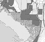
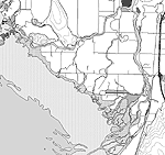
The light green area shown on MAP 1 closely represents an area that was under daily tidal influence before the dikes were built. Because the greatest loss of tidal wetlands in the Skagit has occurred in vegetated wetlands, Map 1 estimates only those areas (tidal mudflats are not included). Of course, not all of this area would have been flooded each day or all year. But the entire area would have been classified as wetland by modern standards (Weinmann, 1984), and the sloughs and wetlands would have been accessible to juvenile salmon as rearing habitat (Lichatowich, 1999).
Map 1 shows that the historic extent of vegetated tidal wetlands for the Skagit was approximately 25,766 acres, and the current extent is 1,941 acres. This means that the Skagit delta has lost approximately 23,825 acres of estuary habitat - more than 37 square miles, or 93% of historic coverage. The Skagit estuary was certainly the largest in Puget Sound, and was of a scale comparable to all other Puget Sound estuaries combined. This finding is consistent with the river's relatively large flow and historical accounts of the Skagit's impressive chinook runs.
Prioritizing Areas for Estuarine Restoration
Since Puget Sound chinook salmon were placed on the endangered species list in 1999, many resource managers have been struggling with the question of how to prioritize restoration efforts. The following set of criteria was developed to tackle this question for rural estuaries, based on attributes of landscape ecology (Shreffler and Thom, 1993) and ease of restoration. The criteria are designed to identify the specific areas needed by fish, while at the same time focusing on those areas where humans and fish can live side-by-side.
-
Landscape Ecology:
- Seasonal Flooding
- Connectivity of Hydrology
- Tidal Flooding
- Ecological Sustainability
Ease of Restoration:
- Public Land
- Land Cover
- Parcel Density
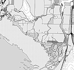
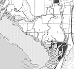
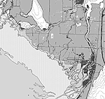
Our estimate of the historic estuary stops at +14.4 feet, but two major blind sloughs cross this line. For this reason and because tidal surges in the main stem extend at least to Mt. Vernon, we decided to extend our region of study to +19.4 feet tidal elevation - about ten feet above mean high tide. In this way we were able to survey an area that represents a diversity of vegetated tidal habitats from forested and scrub/shrub wetlands down to the emergent salt marsh. MAP 2A and MAP 2B show the analyses for the landscape ecology and ease of restoration criteria, respectively. The combined results are shown on MAP 3. A full discussion of all the criteria and the methodology of this survey can be found in Appendix A.
Discussion
MAP 3 shows the survey area divided into four categories of priority. A broad look at the priorities shows a greater amount of high priority area associated with Fir Island than the Padilla Bay area. This makes intuitive sense, as juvenile salmon are entering the delta principally from the two main stems. The additional difficulty of fish passage through the jetty south of La Conner means that restored rearing habitat in Padilla Bay would probably be used by fewer (and more mature) juvenile salmon.
Since most of the criteria are water-based, it is not surprising that the high priority areas are associated with the two main stems, the distributary channels, and blind sloughs, which are the current and historic salmon migration routes and rearing areas. The analysis does not suggest, however, that restoration of fish passage is adequate in and of itself. The majority of the highest priority shading covers areas adjacent waterways, but any slough passage restoration should be accompanied by adjacent and connected wetland restoration. Just as with farming, the amount of food produced and entering the estuarine food web is directly related to the amount of vegetated marsh area.
From a cost perspective, projects that could restore areas between fingers of channels or sloughs would be less expensive, as they would allow restoration with less dike modification. These kinds of opportunities show most abundantly on Map 3 at the mouth of the South Fork.
The second-highest priority areas are more focused on large blocks of land adjacent to major stems and channels. Again, this highlights the need for large areas to be restored as the foundation of the chinook salmon food web. From a cost perspective, one very large project would be cheaper than a number of smaller projects. Of course, most of these large areas are currently farmed and contain residences, so any restoration activity would have to be conducted with the cooperation and compensation of the landowners.
The results of this analysis should also be viewed in light of current restoration activity both up stream and in the estuary. The most recent estuary restoration effort has been at the mouth of the South Fork at Deepwater Slough. Since juvenile salmon migrating down stream must commit to one fork or the other, this suggests that the North Fork would present the next area of greatest need for restoration. Most of the effort in the watershed to date has been focused on restoring and re-connecting spawning habitat up stream, which will increase the amount of juveniles moving down stream and looking for rearing habitat. Over time, it will be necessary to restore enough rearing habitat in the delta to assure that upstream efforts actually result in increased numbers of returning spawners. In fact, saturation of existing estuarine habitat may have already been achieved. (Hayman et al., 1996.)
Appendix A:
Site Selection and Prioritization Criteria for Estuarine Restoration in Rural River Deltas in Puget Sound, Washington
People for Puget Sound developed this set of criteria in order to identify and prioritize areas that would be appropriate for restoring estuary habitat in the Skagit River estuary. The system should be transferable to any rural river delta in the Puget Sound basin.
We defined our survey region as the area between +9.4 and +19.3 feet tidal elevation (U.S. Coast and Geodetic Survey Tide Tables and Charts, adjusted for La Conner, Washington) within the five Watershed Administrative Units (WAUs) that make up the lower Skagit River watershed. We converted U.S. Geological Survey topographic data from geodetic mean high water to tidal elevation (mean lower low water equals 0.00 feet). For a further discussion of shoreline elevations, see http://www.prism.washington.edu/science/projects/seamless.html.
This elevation range provided us with a survey area that would include a variety of vegetated tidal wetlands from emergent marsh to scrub/shrub and forested. This range eliminates the functioning tidal wetlands seaward of the dikes. We excluded from the survey areas above +19.3 feet because tidal influence above this elevation is minimal and largely confined within the main stem of the Skagit River - even historically.
We used a Geographic Information System (GIS) running ARC/INFO and ArcView software to characterize and analyze the region. We converted all the data to grid coverages with a quarter acre cell size to run the analysis.
The Criteria
The criteria are based on principles of landscape ecology (criteria one through four) and ease of restoration (criteria five through seven). Points for each criterion were awarded within a range of zero to four.
In a practical sense, the needs of fish and humans must be combined in order for restoration to move forward. We have provided separate analyses for the two sets of criteria for those who are interested in one need over the other (see MAP 2A and 2B.)
For the combined analysis, we computed a tally for all criteria for each quarter-acre cell, and then divided the scores into four priority ranges (see MAP 3.)
-
Landscape Ecology criteria
- Seasonal Flooding - (0 or 4 points)
Juvenile anadromous fish traveling down stream have access only to habitat that is flooded. During normal seasonal high flow periods, main stem and distributary flooding would have historically been concentrated within and adjacent to natural levees. The historic levee represents a natural rise in elevation adjacent to the channel formed by repeated deposition of sediment from seasonal flooding.
Our landscape analysis of the delta revealed that the elevation that most closely corresponds with the extent of the historic natural levee is 14.4 feet above mean lower low water (the five-foot contour on U.S. Geological Survey topographic maps). We calculated the average width of the natural levee corridors (from one side of the channel to the other) for the river's secondary distributary channels and for its two primary distributary stems. Based on these averages, we mapped 700 foot wide "flood corridors" along the secondary channels and corridors 1400 feet wide along the two main stems.
-
Scoring:
- Outside flood corridor -- 0
- Inside flood corridor -- 4
Data sources: People for Puget Sound (2000) , USGS 7.5' Quadrangles (1968-81), Washington State Department of Natural Resources (30 Meter DEMs, 1997)
- Connectivity of Hydrology - (0, 2 or 4 points)
Juvenile salmonids access the estuary from the top, or freshwater side, and work their way down to marine waters through the salt wedge. But in constricted channels and at high flows, juveniles can be flushed directly into Skagit Bay — forcing them to access the estuary from the lower, or saltwater side. Candidate restoration sites that are connected from both Skagit River and Puget Sound would provide more transitional habitat for juvenile salmonids to acclimate to salt water. Fresh water inputs also carry nutrients to, and create mixed or "estuarine" salinities in the marsh complex - fostering more diverse and productive plant and invertebrate communities.
Access to tidal wetlands that is limited to either the river or the bay is still beneficial to juvenile fish. Off-channel rearing habitat allows juveniles to rest and feed in shallow, slow-moving water away from predators.
Since hydrology was the basis of this criterion, we created "hydro blocks" by looking at barriers to the flow of water, i.e. major roads, levees or dikes. A hydro block is defined as a contiguous area surrounded by barriers to flow. In other words, each quarter-acre cell belongs to a group of cells (the hydro block) that would be flooded if that area were under tidal influence.
Where hydro blocks were adjacent (within one barrier) to juvenile-bearing fresh water (Skagit River), salt water (Skagit Bay, Padilla Bay, Swinomish Channel) or adjacent to both, we awarded the following points to all cells in that hydro block.
-
Scoring:
- Adjacent neither Skagit River nor Puget Sound -- 0
- Adjacent Skagit River -- 2
- Adjacent Puget Sound -- 2
- Adjacent both -- 4
Data sources: People for Puget Sound (2000), Washington State Department of Natural Resources (Spatial Polygon and Line Coverages 1995-97, Orthophotos 1993)
- Tidal Flooding - (0 to 4 points)
Ocean-type chinook swim down to the estuary as juveniles (up to six months old) where they stop to feed for anywhere from six to 189 days (Simenstad et al., 1982). This criterion is designed to target vegetated tidal wetlands and to emphasize a diversity of wetland types.
We used Digital Elevation Models (10 meter DEMs) to create the four elevation ranges represented in the scoring table below. The area below +9.4 feet represents mudflat, and the next two ranges represent vegetated tidal wetlands. We gave zero scores for the area above +16.0 feet because it is above our estimate of the historic vegetated tidal wetlands. Of course, any restoration plan or project concept would have to include more detailed research on historic and current conditions.
We smoothed the elevation surface to remove potential spurious low areas. At elevations below 10 feet, the data were not accurate enough to show actual sinks or small-scale areas of subsidence. (See introductory discussion of tidal elevation, and Data Limitations, below.)
In the scoring we emphasized the +9.4 to +12.7 range because it includes elevations at which we would expect to see estuarine emergent vegetation. Emergent saltmarsh plants are extremely productive and produce detritus which supports the prey of juvenile chinook salmon. Points were awarded and summed within each hydro block (see criteria two). In this way, we were able to emphasize those blocks that contain the greatest range of desirable elevations - which would allow for a greater diversity of habitat type and function.
-
Scoring:
- Block contains cells below +9.4 feet -- 1
- Block contains cells between +9.4 and +12.7 feet -- 2
- Block contains cells between +12.7 and +16.0 feet -- 1
- Block contains only cells above +16.0 feet -- 0
Note: Combinations of the above scores can result is scores of 3 or 4.
Data sources: People for Puget Sound (2000) , USGS 7.5' Quadrangles (1968-81), University of Washington (10 meter DEMs 1999)
- Ecological Sustainability - (0 to 4 points)
This rating recognizes the fact that larger sites are better able to become self-sustaining. According to Shreffler and Thom (1993), "Marshes smaller than 250 acres cannot maintain themselves and will eventually degrade into unvegetated mud or sand." Other benefits of size include increased diversity of plant and animal species, greater ability to hold up against outside pressures such as pollution and invasive species, and the ability to be self-buffering against disturbances such as noise and light.
Shreffler & Thom show that increase in species diversity is nonlinear, with changes in size providing greater incremental benefit in smaller sites than larger sites. Also, at a certain size a site becomes self-sustaining and self-buffering, so these benefits level off as well.
We developed a size index scale based on the species diversity function y = -36.392 + 19.596*LOG(x) from Shreffler and Thom where y equals the number of wetland plant species and x is site area in square meters. Though Shreffler and Thom's analysis is only empirically valid for values of x<500m2, we have adopted use of this equation to larger sites because it yields an accelerated decrease in benefit with increasing site area. The results from the equation are intuitively and practically useful for this particular set of benefits. Because we are applying the formula to more than one benefit, we define y here to be the "size index" rather than "species number" or "sustainability".
Since doubling the area yields a linear increase in benefits, we developed the index for sites ranging in size from a small "pocket" projects (1-8 acres) to larger projects (>256 acres). We assigned all sites above 256 acres the same value because Shreffler and Thom indicate that the size threshold for completely self-sustaining estuarine wetland is somewhere above 250 acres.
The acreage of a potential project is derived from the hydro blocks (see criterion two). We set the size index by taking the mid point of the hydro block size range. We then converted from acres to square meters in order to match Shreffler and Thom's equation. Points for this criterion are awarded by hydro block.
The scores are broken into eight steps instead of four in order to provide a broader range of scoring. This did not make much difference in the Skagit, where the hydro blocks are quite large, but could provide a more diverse set of scores in a smaller or more fragmented delta.
Scoring:
Data sources: Washington State Department of Natural Resources (Spatial Polygon and Line Coverages 1995-97, Orthophotos 1993)Hydro Blocks (acres)
0
1-4
5-8
9-16
17-32
33-64
65-128
129-256
>256
Size Index
0
42.0
49.8
55.7
61.6
67.5
73.4
79.2
>81.2
Score
0
.5
1
1.5
2
2.5
3
3.5
4
Ease of Restoration criteria
- Public Land - (0 or 4 points)
Where land is in public ownership for the purposes of conserving habitat, yet not functioning naturally, it should be a high priority to restore the historic ecosystem functions of that land. The best indicator of habitat function in the estuary is historic hydrology. Historic hydrology provides habitat for fish, but is also highly beneficial for birds and other native wildlife.
Where land is publicly owned for open space (like parks) or other human uses, opportunities may exist to re-introduce habitat elements that do not interfere with other intended uses. In fact, recreational use can be enhanced by providing better opportunities to view wildlife.
Our assumption is that projects that do not require fee simple or easement purchase will generally be cheaper and easier to accomplish. (Of course, some public lands do require a purchase for permanent protection.) For this criterion we simply awarded points for land owned by federal, state, or local agencies.
The only public ownership our data showed for the survey area was Washington State Departments of Fish and Wildlife and Natural Resources. The data did not show private inholdings less than ten acres in size that may exist within these boundaries. The data also did not show areas conserved by private entities.
-
Scoring:
- In private ownership -- 0
- In public ownership -- 4
Data sources: Washington State Department of Natural Resources (Spatial Polygon and Line Coverages 1995-97 and Washington State Public Lands Quadrangle 1988)
- Land Cover - (0, 2 or 4 points)
Where land has been paved or built on, restoration actions are expensive and time-consuming, and may also be less desirable from local social and economic perspectives. While there are clearly social and economic impacts associated with restoration of agricultural wetlands, this usually involves removing less built infrastructure (impervious surface). Where neither exist, the best opportunities for habitat restoration may present themselves - for instance, a previously logged or farmed area that has become overgrown with noxious weeds.
We classified the Washington State Gap Analysis data into the three categories by comparing them to known reference sites on digital orthophotos. The orthophotos provided a good base to register the values to impervious surface, agricultural lands, or areas with un-farmed vegetation.
The impervious areas include buildings, roads, driveways and parking lots. The agricultural areas include orchards, irrigated and non-irrigated row crops, fallow fields, and pastures. The last group includes fresh-water wetlands, riparian habitat below +19.3 feet, logged and other disturbed areas, and forests.
-
Scoring:
- Impervious -- 0
- Agricultural -- 2
- Forests, wetlands, disturbed, logged, etc. -- 4
Data sources: Washington State Department of Fish & Wildlife Gap Analysis (1991), Washington State Department of Natural Resources (Orthophotos 1993)
- Parcel Density - (0 to 4 points)
Permission has to be granted by landowners for estuarine restoration to move forward. The more landowners involved in each restoration project, the more difficult it is to reach agreement. With multiple owners, the costs associated with fee simple purchase or conservation easements (such as surveys and appraisals) increase.
We wanted to avoid giving points to parcels that are isolated from water sources, whatever the size of the parcel, so we awarded points based on parcels per hydro block. Parcels that overlapped hydro block boundaries were counted twice. We did not factor in ownership of multiple parcels, so the data should be considered approximate. We awarded points based on the following curve, reasoning that the difficulty factor would rise rather quickly beyond one landowner.
Scoring:
Data sources: Skagit County Mapping Services (1999)Parcels per Hydro Block
>10
10-7
6-4
3-2
1
Score
0
1
2
3
4
Data Limitations
Issues of data quality limited the accuracy of our results. Without good historic records of the natural levee system, we had to interpret its extent from current aerial photos and topographic maps. This gave us a rough estimate with which to delineate our region of study. However, because the digital elevation model data set was originally created off USGS topographic maps with 10 to 20 foot vertical contour intervals, elevations in the estuary should be considered estimates.
In addition, lack of data also limited our results. In creating hydro blocks, we relied on dike and road data to construct the enclosed areas to water flow. Skagit County has not developed a comprehensive dike data set, and the Washington Department of Natural Resources road data did not include all roads within our study region. Further development of this project would include taking a closer look at aerial photos and other road data to refine the number of hydro blocks in our study.
Further development of this project will also require better land cover data. The only land cover data available to us was the Washington GAP analysis, which classified satellite data into categories such as agricultural lands and seral forest stages. The GAP analysis generalized these land cover categories where two types of land cover may exist within a single cell. Methods are being designed to analyze satellite imagery more accurately, and such data will yield better results in future studies.
Funding for this report has been provided by the Pacific Coast Joint Venture and the U. S. Fish and Wildlife Service Puget Sound Program. Thanks also to the Washington State Department of Natural Resources for assistance with GIS data, to the Conservation Technology Support Program for hardware and software, to the Environmental Systems Research Institute for software, and to the Pew Charitable Trusts for support of the Estuary Habitat Initiative. People for Puget Sound is a member of Restore America's Estuaries.
Bibliography
Aitkin, J. K. 1998. The importance of estuarine habitats to anadromous salmonids of the Pacific Northwest: a literature review. U.S. Fish and Wildlife Service, Lacey, Washington.
Beechie, T., E. Beamer, B. Collins, and L. Benda. 1996. Restoration of habitat-forming processes in Pacific Northwest watersheds: a locally adaptable approach to salmonid habitat restoration. Pages 48-67 in D. L. Peterson and C. V. Klimas, editors. The Role of Restoration Ecosystem Management. Society for Ecological Restoration, Madison, Wisconsin.
Beechie, T., E. Beamer, L. Wasserman. 1994. Estimating coho salmon rearing habitat and smolt production losses in a large river basin, and implications for habitat restoration. North American Journal of Fisheries Management 14: 797-811.
Bortleson, G. C., M. J. Chrzastowski, and A. K. Helgerson. 1980. Historical changes of shoreline and wetland at eleven major deltas in the Puget Sound region, Washington. U. S. Geological Survey, Hydrologic Investigations Atlas HA-617, Denver, Colorado.
Collins, B. 1998. Preliminary assessment of historic conditions of the Skagit River in the Fir Island area: implications for salmonid habitat restoration. Skagit System Cooperative, La Conner, Washington.
Hayman, R. A., E. M. Beamer, R. E. McClure. 1996. FY 1995 Skagit river chinook restoration research. Skagit System Cooperative. La Conner, WA.
Healey, M. C. 1982. Juvenile Pacific salmon in estuaries: the life support system. Estuarine Comparisons, Academic Press.
Lichatowich, J. 1999. Salmon without rivers: a history of the Pacific salmon crisis. Island Press. Washington, D.C.
Mitchell, A. 1999. The Esri guide to GIS analysis: volume 1, geographic patterns and relationships. Environmental Systems Research Institute. Redlands, CA.
National Research Council. 1996. Upstream, National Academy Press, Washington, D. C.
Nesbit, D. M. 1885. Tide marshes of the United States. Department of Agriculture miscellaneous special report No. 7. Washington, D.C.
Pacific Fishery Management Council. 1999. Description and identification of essential fish habitat, adverse impacts and recommended conservation measures for salmon. Portland, Oregon.
Pacific Fishery Management Council. 2000. Review of 1999 ocean salmon fisheries. Portland, Oregon.
Sheldon, D. 1996. Deepwater slough restoration feasibility analysis. Sheldon & Associates, Inc., Seattle, Washington.
Shreffler, D. K., Thom, R. M. 1993. Restoration of urban estuaries: New approaches for site location and design. Battelle/Marine Sciences Laboratory, Sequim, WA.
Simenstad, C. A., K. L. Fresh, E. O. Salo. 1982. The role of Puget Sound and Washington coastal estuaries in the life history of Pacific salmon: an unappreciated function. Estuarine Comparisons, Academic Press.
United States Environmental Protection Agency. 1998. Federal Register Volume 63, Number 45: 1-68, Washington, D.C.
Washington Department of Natural Resources. 1998. Our changing nature: natural resource trends in Washington State. Olympia, WA.
Washington State Department of Fisheries. 1994. Fisheries regulation assessment model: catch-escapement run size calculation summary. Olympia, WA.
Weinmann, F., M. Boulé, K. Brunner, J. Malek, V. Yoshino. 1984. Wetland plants of the Pacific Northwest. U.S. Army Corps of Engineers, Seattle District, WA.
People for Puget Sound
1402 Third Ave Suite 1200
Seattle, Washington 98101
http://www.pugetsound.org
people@pugetsound.org
206-382-7007
U.S. Fish & Wildlife Service
North Pacific Coast Ecoregion
Western Washington Office
510 Desmond Drive SE
Lacey, WA 98503