Authors: Jim Cory and Kelly Ratchinsky
In recent years, GIS and database software providers have
also realized this obstacle to enterprise data access. In response, the
Open GIS Consortium, with membership from main GIS and database software
providers, has been working towards the development of a set of specifications
that address interoperability. Building on this, Palm Beach County is in
the process of implementing an Operational Data Model (ODM) that uses Oracle
Corporation's Spatial RDBS technology to serve data to Esri, Integraph
and MapInfo clients. This presentation describes the status of efforts
at the county and lessons learned in implementing a universal geospatial
database solution.
In September of 1999, GeoAnalytics, Inc., Madison, Wisconsin, contracted with Palm Beach County to develop the "GIS Operational Data Model (ODM) Implementation Phase II". We were very interested in the prospect of assisting Palm Beach County in this project because it was a state-of-the-art implementation of an enterprise geographic information system (GIS) in a mixed technology environment. The project addressed a multitude of issues and challenges that confront many of our clients and the GIS community at large.
The purpose of the project, overall, was the development of an enterprise-wide data repository with the objective of universal, quick and efficient access to a set of Countywide spatial data. It is important to Palm Beach County because of the large public investment the County has made in their information and technology infrastructure. This project has implications beyond the County because it will be one of a very few, full-scale, enterprise implementations based on the OpenGIS™ architecture.
GeoAnalytics sought to approach this project in an objective
fashion using a design methodology that would ensure the best outcome for
Palm Beach County. This meant the project was begun without preconceived
notions regarding implementation, except for the constraints of existing
circumstances. The County had already standardized on Oracle 8i Spatial
Cartridge technology for storage and management of the data, and the mixed
environment across agencies for dealing with that data, while evolving,
was expected to remain diverse. Building from these initial criteria, the
firm used a design methodology to develop data and technology specifications
that would support the ODM processes and serve the best interests of the
County.
Multi-Purpose / Multi-Participant GIS/LIS
The County has a strong enterprise approach to GIS. Their well thought-out organizational structure and defined objectives for GIS implementation are evident in the strategic relationships and technical approach embodied in the County's ODM implementation plan. On one level, the County has chosen to give agencies and GIS staff the ability to maximize technical resources while providing the best available information for use within and between organizations. This approach will enable the County to capture available economies of scale with respect to systems planning, design, implementation and maintenance.
When your administrative unit covers 2000 square miles, encompasses 38 municipalities, and involves 8 constitutional offices and 40 departments, economies of scale are essential to good governance. The County has instituted several organizational, policy and logistical frameworks to facilitate the efficient use of GIS. The Countywide GIS unit (CWGIS) coordinates GIS activity in the county and serves as a clearinghouse for multi-use data. This latter responsibility is performed as a division within the Information System Services Department (ISS). Additional direction is provided by the GIS Policy Advisory Committee and the GIS Project Management Team.
The work of the CWGIS is concerned with a number of foundational elements. The group is compiling a full county base map, consisting of Ortho Photography, Parcels, and planimetrics. This base map is the initial component of an enterprise data structure that will provide critical data, standards, and address geocoding. With the data comes the responsibility of distributing it. Distribution requires the crafting of a fair and equitable information policy and the network technology that allows access to and provides security for datasets that are significantly larger than traditional information resources.
The enterprise approach described above enables users to make use of more advanced technologies than they would on their own. It also offers the County a tremendous opportunity to improve processes by automating data and systems. Enterprise efforts like those undertaken by Palm Beach County make for good public policy because they leverage public resources as well as provide enhanced products and services. As a result, County citizens benefit from a system that supports decision making and efficiency within the government.
GeoAnalytics experience with creating and nurturing various
multi-purpose, multi-participant, and mixed technology GIS/LIS environments
has lead to one inescapable lesson learned from these exercises: they are
significantly more complicated than stand-alone implementations. These
complications involve both technical and organizational issues. However,
if approached carefully and studiously, these challenges can be met and
the benefits realized. This requires using a design methodology to guide
the planning and implementation.
Design Methodology
The structured design methodology is intended to provide a framework for a successful project by ensuring that they are not only comprehensive and complete, but that they also address the business functions and needs of clients. This methodology has been adapted from leading information engineering and systems design research. This approach is particularly useful for planning and implementing enterprise systems like the ODM. It can also help contribute to knowledge transfer if the client fully participates in the endeavor.
There are two dimensions to the methodology, Design Components and the Design Process. The first, Design Components, serves as the analytical and planning framework. There are five design components.
Of the seven design phases, situation assessment, conceptual design, logical design, physical design, construction, transition, and production, the first three had already been completed when GeoAnalytics joined the county in project development. . The situation assessment, an inventory of current conditions and perceived need, was reviewed with respect to current user expectations. The conceptual design yielded a high-level model of the system and was only lacking a review of sites with comparable systems. Lastly, the logical design, that defines what the system is in terms of requirements, needed to be clarified and updated.
The remaining design phases needed to be addressed within the scope of the limited, intermediate implementation plan proposed by the County. The Physical Design defines how the system is going to function. Oracle Corporation's Enterprise Database, and specifically the Spatial Extension ("Oracle Spatial"), had already been identified as the foundational element of the design. Still needed was a specification for applications that would make the system useful to the largest audience. Other key components also needed to be completed, in particular, technology and Framework Data.
The Construction phase involves creating the physical
environment, including the technology installation, data migration, creation
of the organizational framework, and implementing the business process
improvements. The Transition Phase implements the physical environment
across the entire enterprise. Production is the final phase, where the
system becomes part of the standard business practice for the entire enterprise.
Project Background
For the ODM to provide access to all data for all users, it needs to store spatial data in a format that is understandable to each user's GIS software. A great deal of preparation has been done at the County to inventory the nature, extents, characteristics, and interrelationships of existing spatial layers. The GIS tools currently in use at the County to view, edit and analyze this data have also been inventoried. These software products have been categorized as to the agencies that use them, the native functionality of each, and the specific business processes in which they are put to use.
The ODM design developed by the county identified Oracle Spatial as the mechanism for unifying these disparate software and data environments. In particular, the County selected the Object Model within Oracle Spatial as the platform for this data repository. Each of the major vendors whose spatial tools are in use at the County has announced software products that would be compatible with Oracle Spatial and its Object Model. The degree of interoperability that these products would have with Oracle Spatial as well as their scheduled availability were critical issues for the development of a production ODM.
Another application component, web access, had not been proposed or explored in the original design. Web applications that provide windows on spatial data are a hot topic area in the GIS community. The opportunities are much more significant than simply posting data for public access. The web based spatial query tool can be a solution for internal as well as external purposes. Using web-based technology, you can employ thin client, light network demand access to many potential users of GIS within County government, particularly those with limited thematic mapping and browse and query needs.
Palm Beach County combined these new requirements with the earlier design documents and planned a series of implementation phases. The phases are based on the rapidly changing technology as well as on data development efforts undertaken by the County. In order to maintain continuity with the previous design, a review was performed of County plans relative to the design and to the current state of technology. The review included an examination of the characteristics of proposed data layers as well as their relationships to other digital data within the enterprise. Processes and tools to be implemented were evaluated based on the status of other County initiatives and user expectations.
An added benefit of distinct implementation phases is
the incremental approach the problem. One aspect of this was that only
two GIS vendors, Esri and Intergraph, were to be considered in terms of
evaluating interoperability with the ODM. The specific products of these
two companies that allow their clients to access Oracle Spatial are Esri's
spatial server, ArcSDE, and Intergraph's GeoMedia Oracle Warehouse.
Meeting Project Challenges
For the ODM to be successful, its component parts must perform their functions reliably and efficiently and work smoothly together. The central component of the ODM is a relatively new version of Oracle Corporation's Spatial extension. In order to knowledgeably incorporate this component into the design, the county proposed that a prototype database be set up and accessed by applications in use at county agencies.
The Oracle Spatial Extension, version 8.1.5, actually consists of two separate database models, the Relational and the Object. The Object model, which eventually will replace the relational model, allows Oracle to handle spatial data like any other data type. Spatial features are stored as individual data elements within just another column in a business table. Spatial indexes can be built and dropped with the same tools as for tabular indexes. From a design perspective, the object model decreases the number of tables that describe the data. For all these reasons, CWGIS selected the Object model for evaluation in the development of a prototype ODM.
As development proceeded, it became apparent that the actual ODM spatial schema would need to be more complex than indicated above. Each GIS vendor product that accesses the database requires the creation of additional tables and columns in order to manage the spatial object layers within their own specific environments. As a result of this, for example, software that refers directly to Oracle spatial elements may need to access them within tables that have arbitrary names assigned automatically by another vendors software.
The RFP for ODM Implementation, Phase II, originally specified the development of transactional update tools that would provide a regular and consistent method for maintaining spatial layers within the ODM. After further review of County needs and workload commitments, this requirement was substantially reduced. The currently identified requirement is for Parcels to be appended as new areas of the County become converted. There will be one update to the layer incorporating subsequent changes to the parcels, but this will be performed by a wholesale replacement of the layer. As such, the ODM parcel layer does not need transactional logic reflected in the database structure at this time.
A major challenge of the project besides database structure was the goal of application compatibility with Oracle Spatial's Object model. When the project began, all GIS vendors in use at the county supported the Relational model and had announced plans to support the Object model. The County's desire to wait for these enhanced products meant that project development needed to be sustained across periods of down time.
The capabilities requested in the RFP to be provided by
the web tool are ones that most vendors supply. Some may require additional
server components such as ArcSDE or Internet Map Server. Others may require
extensions to desktop applications depending on the brands of browsers
supported by County agencies as with GeoMedia Web Map. While there are
advantages with either strategy in delivering spatial information to the
desktop, whichever product is selected must fit into the current County
IT infrastructure.
Solutions
At the time of the writing of this paper, some required software components of the project have yet to be released. Until they are, a complete picture of how the ODM will be constructed is not possible. Based on what we know now, however we can propose preliminary scenarios for data loading and access. One important criteria of these solutions is that update of Oracle Spatial layers be synchronized across each of the GIS vendor's specific data structures.
Data loading can be achieved in a number of ways. Each of the vendors provides a mechanism for creating Oracle Spatial layers. There are also several third party products that support the translation of many GIS formats into Oracle Spatial, for example Safe Software's FME. Since there is no need for transactional management at this time, a simple batch load of the data using one of the GIS vendors will probably be sufficient.
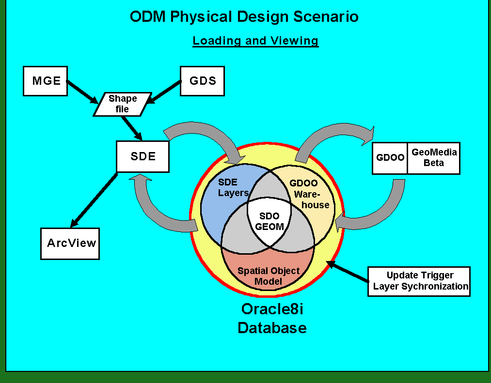
Synchronization of the spatial layers across the various vendor schemas will rely on the ability of the GIS tools to register existing Oracle Spatial layers. The current version of ArcSDE, 8.0.1, supports this mechanism. GeoMedia 3.0 supports registration of Relational layers, with support of Object layers scheduled for the next release. As a way of visualizing this interaction within the database, Figure 1 offers a schematic illustrating the relationship between the various entities.
Figure 1
The other major software product requiring access to the
ODM is the Web tool. The County investigated a number of candidates for
this component and in the end selected ArcIMS from Esri. The product offers
a wide range of options for delivery and functionality, but is in the initial
stages of release. The County's preference was for implementation of the
option that utilizes Java for all major services. The customizing tools
for this component, however, are still some time from release. For this
reason, the version that utilizes Microsoft ASP technology was selected
for initial development of the tool. This choice also follows current web
develop trends within the county.
Implications And Opportunities
As has already been mentioned, this project is taking place during a time of rapid change in the information technology environment. While this has been true for several years in the software industry as a whole, it is especially true right now in the world of GIS. Not only are the major vendors in the process of releasing revolutionary new versions of their core software, but it is a time of great mergers of many types of data within mainstream corporate database installations.
If one has the luxury of delaying certain production systems, there is an opportunity to come out a little ahead of the technology wave. Within this transition phase, one must weigh the risks of marshaling ones forces behind unproved technology verses maintaining applications that have been developed using older, soon to be obsolete technology.
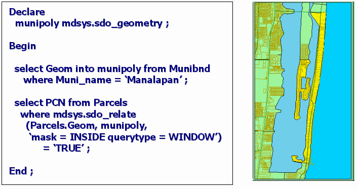
Figure 2
There are many new realms of information appearing on the horizon. There is the promise of a more realistically modeled world based on the natural properties and methods of objects within the database and the application. The line between database and application is also blurring, so that for one operation the developer may choose to leverage the centralized processing on the database server to perform some tasks. An example of this is shown below in Figure 2, where, using standard PL/SQL, a spatial overlay is performed within the database.
Figure 2
Whichever way is chosen, there will be benefits from having brought the data together in a centralized, uniform database and by providing the means of access for all users of spatial information, whether they are experienced or novice. Access to information helps drive successful public and private ventures in a world where we are being asked to manage our assets economically and with an overview of the broad interrelationships of often-conflicting elements.
REFERENCES
Lisa Warnecke, Jeff Beattie, Cheryl Kolin, Winifred Lyday,, 1998, "Geographic Information Technology in Cities and Counties: A Nationwide Assessment", Urban and Regional Information Systems Association and the American Forests.
Jim Cory
GeoAnalytics, Inc
Madison, WI 53704
Ph 608-241-7100, Fx 608-241-7116, coryj@geoanalytics.com
Kelly Ratchinsky
Palm Beach County
West Palm Beach, FL
Ph 561-355-4275, Fx 561-355-4120, kratchin@co.palm-beach.fl.us