1)Wen-Yuan Ku , 2)Jing-Ming Wu
Abstract
The control and management of infectious disease is one of the most important missions to health department. When infectious disease happened, traditionally, we mark patient’s location on the paper map, and create patient’s base data by computer. But this method cannot build the link between patient’s base data and spatial data, so this paper will offers new method. We used a GIS to build an infectious disease management system that provided management, analyze, and print functions. Furthermore, we can provide information by the Internet, WWW user can use browser (ex. IE or Netscape) to query infectious disease information.
Now, we have 2 ways to report disease case in Taiwan:
Whatever they use any way, when the case report is completed, the case report will send to CDC for management and control unified.
The present infectious disease management system in Taiwan, patients’ data will be saved in CDC’s computer after the cases reported by Medical Care Network. By the MIS’s statistic and analyze functions that can produce various information and reports. Although present MIS make many useful reports, but MIS could not save and display the location of patients.
In order to control the distribution of infectious disease case rapidly, department of disease control in Taiwan mark the patients’ location on maps, or mark the sum of patients in each administrative division on the map. However, patients’ basic data and spatial data are separated, we could not know every patient’s data form the map.
Operating system:
Microsoft Windows NT 4.0 with Service Pack 4
Development software:
Microsoft Visual Basic Version 6.0
Esri MapObjects Version 1.2
Esri MapObjects IMS Version 2.0
MapObjects is an OCX(OLE Control) component, and it makes system developing staffs to develop the needful GIS Application in the system developing environment (ex. Visual Basic, Delphi, Visual C++, etc.). MapObjects, is similar to the OCX component, conforms to the standard of Microsoft OLE(Objects Linking and Embedding) and offers over 30 variety of OLE Automation Objects. The system developing staffs control the Automation Objects by programs in the developing environment, and design the needful functions to users.
MapObjects IMS is the extension of MapObjects. By MapObjects IMS, the application which is developed by MapObjects, will apply to Internet. Other WWW users can use the system by browser (ex. IE, Netscape). The advantages of using MapObjects IMS as an Internet query tool are:
(2) System frame
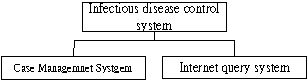
The system frame could be divided into 2 parts, one is Case Management System and the other is Internet Query System.
I.Case Management system
Case Management system based on Project. Users could cover and display various infectious disease maps at random; furthermore, in order to make the system elastic, users could build a new kind of infectious disease except statutory infectious disease to fit in with later demand.
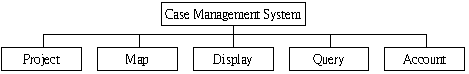
The Case management system is divided into 5 sections, and the frame as follows:
II. Internet Query System
In order to make people understand the epidemic situation and prevent them from phobia, we use MapObject IMS to put all infectious disease data on Internet. People can query the epidemic situation from Internet.
(3)System functions
I. Case Management System
Its functions are followed:
a. Case Management: Case Management system bases on project, so users are able to build the new project, open the old project or save the project depends on their demand.
b. Account Management: In order to the security of system, users must to pass through the identification before they enter to the system. System offer add, edit and delete functions, system administrator can maintain user’s data.
c. Map Display and Control: System offers all basic operating functions of GIS, including zoom in, zoom out and pan.
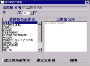
d. Infectious Disease Categories Management: Each kind of infectious disease is a single layer in the system and users could add any infectious disease layer on the map. If the system’s infectious disease categories are not enough they could create a new infectious disease category by themselves.
e. Infectious Disease Factor Layer for Users to add on the map: We design the vector index layer and ground water index layer for users to use that; they are able to set infectious disease factors up by year and month of data.
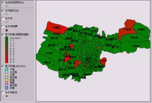
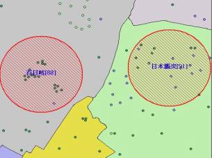
f. Analyze the high dangerous area of infectious disease: By result of dangerous area analysis, we can mark the dangerous area and provide the result to control of disease department for reference.
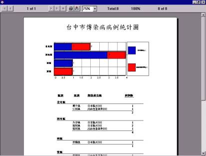
g. Print the reports: Two System reports for users, one is the case basic data report; the other is the case statistics in each administrative division.
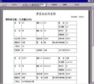
h. Infectious disease case report: 4 kinds of report method—reported by intersection, landmark, map and administrative division.
i. Statistic functions: Two statistic functions for users, one is the single infectious disease classified statistics; the other is the statistics for the number of cases in each administrative division.
j. Case query: The system offers 3 kind of tools to query case—spatial query, query builder and query on the map.
II. Internet Query System
Its functions are followed:
a. Query distribution of the infectious disease: Let people to query distribution of the infectious disease.
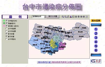
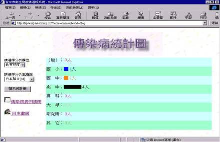
b. Infectious disease statistical charts: Let people to query the infectious disease statistical data.
Now, many government departments in Taiwan led GIS into their affair. We believe that it is considerable to apply GIS on disease control in the future.
This research shows some ideas to use GIS in infectious disease control; however there are some problems before leading GIS into infectious disease control:
(1) How to translate the original MIS database to GIS database.
(2) The system built by the study offers 3 ways to mark the case location, but it marks location by man-made after all. It deserved to research how system marks the location automatically.
(3) The high dangerous area of infectious disease analysis has not integrated the infectious disease-spreading model. It also deserves to research how to build various infectious disease-spreading models.
2.Esri, 1996, MapObjects Programmer’s Reference
3.Esri, 1996, Building Application with MapObjects