Hoon-Joo Yoon
ENTERPRISE GIS of
KANGWON PROVINCE
Joong-Hi, Ryu
CADLAND, Inc. , Chief of GIS dept.
Suite #804, Diplomatic Center, 1376-1 Seocho 2-dong,
Seocho-gu, Seoul, Korea
tel: 02-571-1101 fax:02-571-1311
jhryu@cadland.co.kr
Hoon-Joo, Yoon
CADLAND, Inc. , Project manager of GIS dept.
Suite #804, Diplomatic Center, 1376-1 Seocho 2-dong, Seocho-gu, Seoul, Korea
tel: 02-571-1101 fax:02-571-1311
hjyoon@cadland.co.kr
Bang-Bum, Choi
Kangwon Province Office, Official of Information dept.
Kangwon Province Office, Bongi-dong, Chunchon-si, Kangwon-do, Korea
tel: 0361-249-2136
choibb@provin.kangwon.kr
Jung-Dai, Kim
Hyungdai Information Technology, GIS dept.
Suite #901, Woorim Building, 1306-6 Seocho-dong, Seocho-gu, Seoul, Korea
tel: 02-3466-4222
kimdc@shinbiro.com
Abstract
The purpose of this article is to explain the 1st pilot project
about developement of the GIS. at the Kangwon Province in
Korea. This project is for 3 interested parts (Tour, Environment,
and Forest). Using Esri's Component GIS tools, we had developed
the management applications for provincial authorities
and the data input web applications
for county authorities. Furthermore
both analysis programs customized by using ArcView and map management
program used by ArcInfo were built. Especially the analysis program got the favorable comments
when it was used for decision making ( Effects of dam construction and its
environmental assessment, forest fire simulation , finding the
suitable air monitoring sites in Kangwon province, and etc.)
1. INTRODUCTION
Kangwon Province contains some of
the country's most impressive mountains and national
parks. The mountainous terrain also provides excellent
slopes for several ski resorts and rafting. The east
coast has many sandy beaches, hot, and mineral springs.
To preserve these natural resources systematically,
the Province of Kangwon decided to develop a
Geographic Information System as a supporting tool of
decision making and operational management activities in 1998.
In general, the computerization skills of the officers
were quite low and it is considered inappropriate for
GIS. Regarding the level of information technology
application in the Province of Kangwon and long term
master plan of GIS that has sufficient education for
employee had stood. In the order of priority,
departments of Tour
Plan, Environmental Managements, Forest Managements were
selected for developments Esri products were adopted as a tool for developing
application because they have many other successful
sites in this fields.
#
Main scope of work
I. Increased the basic system capabilities for GIS (H/W, S/W)
II. developed the program for four office fields
III. built the Database
2. THE 1st pilot Project(1998.9 ~ 1999.10)
2.1.
The basic system configuration for Kangwon (H/W, S/W)
-
Server : Sun Enterprise450, Ultra10
-
Input/output
peripherals : Calcomp Scanner / HP
Plotter / GTCO Digitiger
-
Software : Delphi +
MapObjects (Client application)
MapObjects IMS +InterDev (Web Application)
ArcView + Spatial / 3D Analysts(Analysis Program)
ArcInfo + ArcStorm(Map Managemants Program)
-
Database : Informix 7.0.3
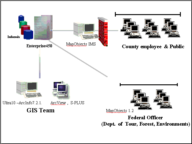
Figure 1.
System diagram
2.2. Applications for four office fields
2.2.1 Forest
The Department of Forest management is responsible for
wildfire protection on 16,873Km2 of private and National
forest land.
At that time, forest fire employee looked up the fire place
on a paper map with the coordinates films created by OHP.
It will take an hour to find place because of the searching
more than 1000 paper maps. In an emergency, the fire fighting
helicopter should be standing by ready until fire forest
employee notify the coordinates to pilot. GIS analysis program
helps them to find the fire place quickly and supports
various projection like UTM and TM only by the clicking
some buttons. And they can make the plan of the fire
protection through the spider analysis that shows the network
relationship from fireplace to lake used the water of fire
prevention.
The expected paradigm shift is gradually
taking place among the employees. In addition to forest
fire management function, Analysis program helps employees
who manage the pine tree to prevent the pine tree insects.
Through the overlaying pine tree distribution map and the
outbreak area map of pine tree insects, they'd learn on
what places should be sprayed an insecticide by helicopter.
The department of forest management can save a lot expenses.
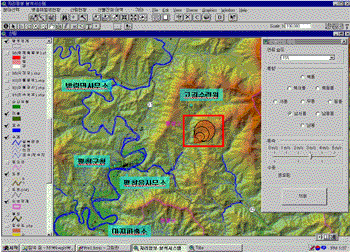
Figure 2. Fire
simulation
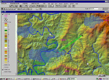
Figure 3. Spider
Analysis

Figure 4. Find the
sprinkle insecticide area
2.2.2. Environments
In 1998, Ministy of Construction and Transportaion was
promoting new plan of dam construction and drew up a
budget to solve the water defiency problem. They decided
to construct the new dam suitable for Yongwol county in
Kangwon province. Many environmental organizations had
filed an appeal canceling the license of the Tong River
dams located in the Yongwol in Kangwon Province, on the
grounds that the power operations will threaten the eco-
system and degrade the water quality of one of Kangwon's
most important rivers. Neither would make a conssessiosn. The dispute was settled through president's promise that
cancels the Tong river dam project (1999 .11). but there
are other plans of the new dam construction in Kangwon
province by Ministy of Construction and Transportaion.
It put the Kangwon province employee related the dam in
an awkward position. Inhabitants, environmental
organization, a member of the provincial Assembly, a
Congressman, and even the governor of a province asked
where could be flooded, what school be sank and how long
road be under water. We have satisfied their demand
with the analysis program built in ArcView. It
can show the flooded area at a time through simulating
the dam construction with watershed and grid analysis
and the lists of feature data presenting flooded area. In second function, when the employee decide to add the
air monitoring implements in Kangwon area, system find
the most suitable place through the spatial interpolation
analysis and it has useful following functions; managements
of water pollution source, simple watertank and a preserved
upper stream. We edited all the maps on 1: 5,000 scale.
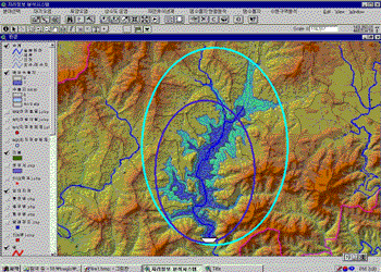
Figure 5 Estimate
submerged districts by new dam
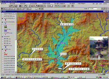
Figure 6 Estimate
submerged districts by new dam
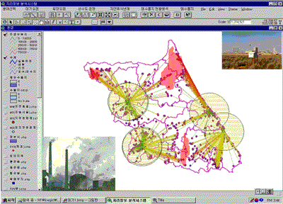
Figure 7 Find
the suitable air monitoring site
2.2.3. Tour
The International Travel Expo '99 was held in Sokcho,
Kangwon Province from Sept. 11 to Oct. 30, The officers
of Tour plan department, Kangwon wonder the minds
of people there : How do they successfully host the exposition.
And how can they make the province more popular among both
Korean and foreign travelers in the next century? They needed
to analyze the statistics data for attracting tourists to the
their province. Our system also present good solutions by
using S-Plus plug-in. Using the time series analysis, we made
an analysis program for each county comparing the number of
native with that of foreign travelers. Predicting the results
by our system helps them to decide a operational
costs. Of
course, through the DDE(Dynamic Data Exchange), we shows the predicted results in
Arcview.
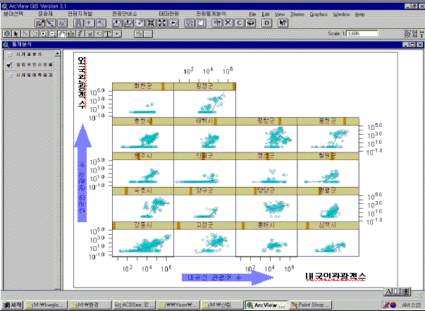
Figure 8
Estimate the future tour trend using the S-PLUS
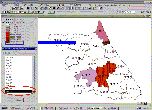
Figure 9
The map statistics from S-PLUS
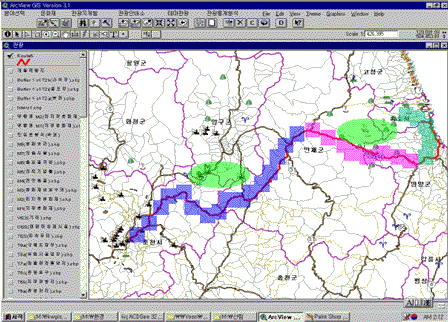
Figure 10.
Network Analysis - Origin-Destination-
3. FUTURE PROJECTS
According to the Kangwon Total GIS 21 plan,
the next step is the dealing with disaster management system.
The Province administration would like to partly open the
geographic data to many people who have interests through
the internet. The supporting policy decisions and
assisting the plan on the municipality is being considered
through project. To satisfy these demands, we'll upgrade
internet applications to be used on the internet with ArcObjects
of ArcInfo development tool. Establishing the
department of internet and GDN(GIS Developer Network) that
train the professional internet solution, our company get ready
to next project for Kangwon .
4. CONCLUSIONS
Compared with another similar projects,
the Province of Kangwon opted for a basic and simple GIS
technology in the first pilot project, that will gradually
be replaced to more sophisticated one in next. The initially
obtained result was the large dissemination of the GIS technology
within the Province's services. It has been practical in daily officer's
work. A noticeable achievement is that the GIS concept of coping with
data of spatial nature by means of GIS funcionalities has affected
the mentality of the employees so that the implementation of the new-
GIS based technology is now enthustiastically being proposed for
almost all the new projects. As a result, It's important to implement
proper methodology of training. It should be flexible, personalized,
sustainable. It is most desirable that both trainer and trainee take
part in GIS intorduction in solving the ongoing operational problems .