
GIS is at the core of LEMA Company�s corporate plans for improving efficiency in almost every business area. As part of the overall strategy, LEMA Company has further developed its GIS Maintenance Management System (MMS), by integrating it to manage defects reports from its new Customer Call Centre, as well as from its core networks maintenance and leakage units.
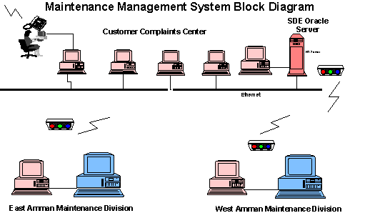
The MMS required fast multi-user interactive access to the GIS by staff answering the customer complaint telephones; whilst at the same time giving access to other ArcInfo and ArcView users. These requirements led to the introduction of a spatial database engine SDE based GIS, linked to external Oracle databases, all mounted on an NT platform. A number of call centre and operational staff have direct network links via ArcView to the SDE. The Core GIS ArcInfo running in UNIX is also networked to the SDE; this unit has responsibility for updating the basic network drawings and the cadastral mapping. The maintenance of the system requires not only integration but also data integrity between GIS features and the RDBS data.
The introduction of the integrated NT, UNIX, SDE Oracle, ArcInfo and ArcView system, was a complex problem in an environment where GIS/IT is still fairly early in its development cycle. It meant the LEMA and InfoGraph, the local Esri agent, had to work as a team to respond to the development challenge, and to make sure that the product was user friendly for end users, with no IT experience, in the operational units of the water company.
This paper discusses the LEMA�s integration of ArcInfo, ArcView, Oracle and Esri�s Spatial Database Engine (SDE) in the companies new centralised Maintenance Management System (MMS). This MMS was developed to allow LEMA to start a Centralised Customer Complaints Centre, so that all customers could have access to an efficient complaints handling system via one phone number. GIS is at the centre of the MMS because there is not a strong tradition in using addresses/street names, and customers prefer to describe locations to call handlers working directly with PC based maps.
LEMA operates a Core GIS unit responsible for the capture of all basic asset data, as well as for its maintenance. This Core GIS unit , which operates ArcInfo, therefore has ownership of all the network and cadastral maps. In the MMS development, the Core GIS unit products had to be integrated into Oracle databases on the SDE, so that the ArcView MMS application, also operating on the SDE server, could allow a number of operators to deal with calls from many different customers simultaneously.
The MMS�s integration of ArcInfo, ArcView, Oracle and SDE has been carried out in an environment not accustomed to complex IT systems. However the success of applications like the MMS in LEMA�s daily work illustrates that complex solutions can be presented in user friendly applications that are immediately accepted, and quickly add value to the business.
The most pressing needs and priorities of LEMA in the GIS implementation were:
Improvement of customers relations / management through the introduction of centralised complaints management
Introduction of a computerised maintenance / complaints management to handle 290.000 customers and about 70,000 complaints per year for the Greater Amman area.
Establishment of a monitoring and follow up system for the Maintenance & Repair Division.
The Technical Services Division, represented by GIS-Section took on the challenge and started the development of an integrated concept, linking GIS products with Oracle database applications for LEMA service area.
Customer complaints are difficult to monitor and control manually
In order to report problems efficiently customers needed to know all the telephone numbers for the Maintenance Division repair offices, and to which maintains division he should call for his complaint type.
Within the manual system there is no unique reference for customer complaints
Customer complaints cannot be geographically located
Slowness of manual work (Response time is very high), because there is no reporting on progress
Inaccurate paper maps resulted in no one making use of maps.
Maintenance boundaries were not available on maps.
Complaints and repairs information can not be used in the business process and planning of LEMA
Improve Customer relations by providing only one central complaint telephone number for the whole service area.
Introduce complaint monitoring & controlling procedures
Clear up & increase the transparency in the complaints procedures
More up-to date, accurate, and reliable information.
Reduction of the response time.
Targeted investment planning for rehabilitation projects
Better customer service.
Higher - quality products such as maps and statistical reports.
Ability to estimate the cost for each repair.
Controlling the teams and monitoring the network repairs
Increased productivity of individual workers.
The Customer Complaints Center System was developed under an ARCVIEW based Maintenance Management System application (MMS), and integrated with ORACLE and SDE. All relating and exchanging information with the GIS core unit, which is responsible for updating and editing of all network and Cadastral maps under ARCINFO.
The overall integration of ArcInfo/ArcView/SDE and Oracle is shown in below:
The Complaints Center receive, dispatch, monitor and follow up the customer complaints for the whole Service area .The basic concept of the center is focused on improving the customer oriented services, accuracy & transparency enables closed integrated information cycles, speed up response time, monitoring & control of the different functions.
The Center accepts customer complaints that are related to the water network (i.e. pipe burst, no water, realignment of water pipes), sewerage network complaints, illegal water consumption, no bill delivered to customer and water quality related complaints. These complaints are stored on the Oracle database and the complaint information transfer from complaint center to the various divisions and vice versa using the conventional way (i.e. fax or fax modem card). In the near future virtual networks or frame relays will be set up to replace fax correspondence.
MMS is a GIS integrated, operational front-end system intended to support all Maintenance Divisions in efficient planning, monitoring and execution of repair services. The system allows the Maintenance Divisions to:
Record and track complaints
Create and process work orders sheets, including maps
Enter and track daily activity information and produce a wide range of resource utilization and other reports regarding the maintenance activities.
MMS further provides valuable information to LEMA management in respect of targeted investment planning, management contract monitoring / control and customer services.
All of the maintenance activity data is stored in database form. However, most of the functions of MMS are accomplished using customized Arcview GIS software. The following screenshot shows a work order sheet of MMS application.

The communication between the MMS application and maintenance divisions are through Modems connected to telephone lines, MMS user log in to Oracle and SDE through ODBC driver, once linked the user can take a complaint live from the customer identifying his location exactly and then send the work order sheet electronically by Fax/Modem to the maintenance divisions. Repair action is taken; when it is completed they returned the work orders back for update to close the cycle.
The MMS was developed for end users without any background and knowledge about computers. After an initial training of Maintenance Division staff, and a test period, the speed of the response and the quick production of work order sheets was tested in various configurations.
The implementation had to consider the existing procedures and was initially commissioned at the Maintenance Division offices, as all complaints in respect of leaks and no-water were received there.
MMS was installed centrally in November 99 at LEMA�s head office, it initial covered two Maintenance Sections while now it covers all the Amman Service Area, a total of 290,00 customers are covered, only 7 PC�s and 1 server were needed, no additional staff were employed. Intelligent programming allowed the use of relatively low-end hardware, still achieving fast response & performance.
The table below shows some key data of MMS implementation
|
Description |
MMS |
|
Evaluation Period |
7/11/1999 - 3/12/1999 |
|
Total no. of complaints |
6187 complaints |
|
Daily Distribution |
Average 200 complaint per day |
|
Received / Completed |
6187 Complaints Received / 6077 completed |
|
Software |
|
|
Hardware |
|
|
Personnel |
16 data entry / working with MMS for three shifts |
A total number of 6187 complaints were received during the test period.
The evaluation yielded very positive results and fully justifies the implementation of MMS in all LEMA maintenance divisions, as:
Response time and recording of complaints was reduced
Work order sheets produced out of Arcview had an accuracy of complaint location within the sheet of 97%.
Work preparation was reduced to minutes and control of staff performance greatly improved.
Maintenance and construction activity relating to labor, materials and equipment tracking will provide accessible, up-to-date and accurate information to the decision makers.
The analysis of leaks in Arcview could identify places with highly corroded pipe lines, low team performance and low quality repairs (13 complaints within 19 days), this providing an excellent decision making basis for the management.
By visualizing and showing leakage points on maps MMS revealed that the repair frequency in rehabilitated and new networks in Contract 1a area was not better than old areas of the network. Site checks exposed that the old network was not properly disconnected.
The proper geographic documentation provided the proof that 80% of leaks are on service connections . With those results, LEMA can revise the rehabilitation strategy to carry out more connection replacements and reduce investments considerably.
The table below shows the Comparison Between Old and New Procedures
|
Item / Criteria |
Old Procedures |
New Procedures |
|
TIME Time needed to locate a complaint: Time needed to Print work order sheet: Time needed to prepare work order sheet: |
15 Minutes Not Available 30 minutes per team (10 complaints average) |
30 seconds 30 seconds 10 minutes per team |
|
Accuracy of Complaints location Inside selected Box: Inside the sheet: outside sheet: |
|
90% 97% 3% |
|
Response Time 0-6 hours : 6-12 hours : 12-24 hours: 24-48 hours: 48 hours : |
Not available on hourly bases |
20% 27% 50% 7% 3% |
|
Performance of the teams Follow-up, checking & monitoring of WOS Updating of landmarks, street names & house connection on sheets Monitoring of quality Map Location Preparatory of work |
No sheets are available Not Available No criteria takes long time takes long time (90 minutes) |
30 sheets per day 10 sheets per team Quality was improved by checking of each sheet Random check on the field Analysis of data Takes less time Takes less time (30 minutes ) |