ABSTRACT
Recent market analyses indicate that more and more GIS professionals are utilizing digital orthophotography for their base mapping needs. This paper examines the latest technological advancements in digital orthophotography production. These advancements are sometimes misinterpreted, misunderstood, and sometimes alienated by the GIS community when procuring orthophotos. Ultimately these advancements provide GIS professionals with a cost-efficient orthophoto basemap solution without jeopardizing accuracy, image resolution, or overall quality. The goal of this paper is to provide the GIS data purchaser with descriptions of recent production enhancements and how they can reduce project costs while yielding an improved product quality.
All technology-based industries are in a continuous state of evolution; in photogrammetry, emergent technologies provide photogrammetrists with an innovative means of providing equivalent or improved mapping data at a significant cost or scheduling savings. The object of the reputable photogrammetrist is to evaluate these new technologies, testing them against the accuracy of known and trusted methodologies, and to ensure that any cost and scheduling savings do not come at the cost of product accuracy or precision. This paper will discuss the viability of five recently emerged technologies that significantly will impact the course of digital orthophotography
Prior to incorporating any new technology into its production process, Surdex subjects new technologies to extensive and thorough testing; to reduce errors in findings owing to small test samples, testing is repeated until findings can be conclusively demonstrated.
With over 40 years of research and development experience, Surdex has established a 1700-Acre Test Site in St. Louis County, Missouri. This site, known as the "Ballwin" Test Site, has over 150 known vertical points located on photo-identifiable black iron manhole covers. This test site is controlled horizontally by eleven (11) known surveyed points around the perimeter of the project. These control points were established to First Order accuracy. Surdex has used the Ballwin Test Site to test the five evolving technologies that will later be discussed.
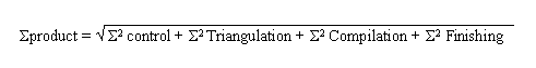
Surdex utilizes Statistical Process Control (SPC) to validate and test emerging technologies within the photogrammetric industry. Overall, product accuracy is the statistical summation of the errors associated with each of the parts of the production processes. The equation below allows us to statistically validate new technologies in virtually every phase of photogrammetric production.
The accuracy or quality of the final mapping product can be assured by limiting the errors at each of the production steps. Surdex eliminates the causes of production problems systematically, and verifies the quality of the products statistically. When testing new technologies, we monitor each project based upon the stipulated specifications and statistically verify that our resultant mapping products remain well within known accuracy tolerances.
The remaining sections of this paper will evaluate five recent
technological advancements, demonstrating their viability as trustworthy
tools for the photogrammetric industry.
Photogrammetric control provides the foundation for spatial orientation or referencing of aerial imagery to the Earth’s surface, thereby allow the imagery to be used in the photogrammetric compilation of topographic and planimetric mapping features. The accuracy of the photo control solution is dependent upon the desired accuracy specifications of the resultant mapping products. Since the ground control solution provides the framework and accuracy of the entire process, this initial step is the most critical.
Traditionally, the photogrammetric control solution was accomplished through the establishment of a basic network of "photo-identifiable" ground control points with known horizontal and vertical values within a specific ground coordinate system. These points have known coordinates (x, y, and z) on the Earth’s surface and can easily be identified in the aerial imagery. For some large scale mapping, it was often necessary to have a ground control point in at least every third or fourth stereo model. In those cases, a countywide project would often require as many as 1000 control points for the photogrammetric control solution.
Surdex was a pioneer of Airborne GPS collection for photogrammetric control, having undertaken experimental research with Iowa State University and with our first project in 1991 for the USGS. Since that time, Surdex has routinely used this technology to support, and often to supplant conventional ground control for the Corps of Engineers, USGS, USAF, FAA, and County/Municipal photogrammetric survey and mapping projects.
Although Airborne GPS is not a new technology, it is often misunderstood and its viability in the photogrammetric process is often questioned by many non-photogrammetrists. Digital Orthophotography is a perfect application for Airborne GPS. The airborne collection of photo-center control data allows the user to collect an extremely dense data set of photogrammetric control in a very short period of time. Essentially, a photo-center control point is established for each frame of photography flown during the mission, as opposed to establishing control points spanning three to four models utilizing conventional ground control.
During the photo mission, a minimum of three GPS receivers are simultaneously collecting GPS observation data at 1-second intervals. The airborne unit collects both at one-second and at an event epoch, which is the center-point of the exposure cycle for each frame. Two receivers, or "base stations," are generally co-located with previously established, or to be established, high accuracy ground control points. A third receiver, the "rover" is located in the aircraft and utilizes an L1/L2 antennae which has been surveyed into the aircraft’s coordinate system, all referencing the nodal point of the aerial camera’s lens and known focal length.
Surdex has independently executed specific experiments to determine the accuracy of Airborne GPS as solitary control for a project as well as evaluating the affects of minimal perimeter conventional ground control on the vertical accuracy's.
As a result of these tests, Surdex has determined that Airborne
GPS is adequate for horizontal control. Even without additional
ground control, Airborne GPS data does not reflect any serious
effects of deformation in the triangulation. The expected problem
would result in tortional deformation longitudinally along the
flight line, since airborne control is collected along a straight
line through the air. However, there is enough excursion variation,
such as drift and altitude change, along the flight line to suppress
any adverse effects. Additionally, the geometric strength of normal
strip triangulation minimizes the tortional deformation as well.
The combination of triangulation and flight variation guarantees
elimination of the problems expected from linear collection in
the air.
SCANNING FROM AERIAL NEGATIVES
In order to be used for digital orthophotography, any aerial photograph exposed in an analog camera must be translated into digital format. This is accomplished by scanning the aerial images with a radiometrically and geometrically precise digital aerial film scanner. When scanned, each pixel of the aerial image consists of a radiometric value plus an XY coordinate set unique to that image. Until recently the most accepted methodology to do this was to scan from film diapositives; a diapositive is a second-generation positive reproduction of the original film negative with positive tone. Once scanned, the photogrammetrist develops a histogram to adjust radiometric contrast to insure that the raw data has a more pleasing overall image tone.
The problems associated with this process are three-fold. First, scanning from a second-generation product creates a third-generation scan. It should be noted that each replication of an image is destructive to the overall accuracy, precision, and quality of the original aerial image. Imagine taking a photocopy of a photocopy of a photocopy … it’s easy to visualize the rapid loss of resolution. When photogrammetrists scan from a film diapositive, they are using a "copy of a copy" as their source material, the source material upon which the entire basemap is based. Secondly, the process of scanning from a film diapositive is extremely laborious; the photogrammetrist must load each individual diapositive into a single frame flatbed scanner. Conversely, technicians can scan continuous aerial photography film directly from the spool in an automated fashion. Consequently the costs for scanning from hand-placed diapositives, in comparison to scanning direct from film, is significantly higher. Finally, the chance of image degradation is increased significantly due to processing blemishes or excessive handling of film diapositives.
To combat the problems associated with scanning from second-generation film diapositives, Surdex scans directly from the archive-quality aerial negatives with our Vexcel VX4000 Digital Imaging Systems, radiometrically and geometrically precise digital aerial film scanners. The VX4000 is capable of scanning an entire roll of aerial film at one time, significantly automating the digital imaging process. The VX4000 will accept rolls of film up to 500’ in length. It has a Geometric Accuracy of 1/3 pixel RMS. For example, the geometric accuracy of a 7.5-micron scan will be 2.5 microns. The Radiometric Accuracy is 2 gray values RMS, and the pixel depth is 8 bits monochrome and 24 bits color (8 bits per color).
Our testing universally affirmed our premise that scanning
directly from film improved the quality of the scans, plus all
subsequent mapping products, as well as significantly improved
schedules. Additionally, the Vexcel scanners allow us to preprogram
scanning requirements for a full 500’ roll of aerial film.
Histogram and scanning parameters are applied to the entire roll
insuring that the project imagery is radiometrically precise.
In some cases, it may be necessary to scan individual frames as
opposed to the entire roll. This process too can be programmed,
thereby yielding the same time and cost savings.
DIRECT CAMERA ORIENTATION MEASUREMENTS
The purpose of aerial triangulation in the photogrammetric production process is to establish precise and accurate relationships between the individual photographic film coordinate systems and a defined datum and projection. This relationship is used to link the ground surveyed control points via photographic measurements. This activity is often termed "geo-referencing" of the aerial imagery.
Traditionally, the photogrammetrist takes photographic measurements with precise photogrammetric instrumentation to be processed through computer algorithms; this process is designed to eliminate blunders and systematic errors from the data while minimizing the residual random errors within the entire triangulation network. The result of the triangulation is a densified set of ground control points that are used to control the remainder of the mapping process. The triangulation can be thought of as an interpolation process where a dense pattern of ground control points, known as pass points, are interpolated from a sparse pattern of surveyed ground control points and Airborne GPS (ABGPS) control points.
Surdex employs the POS/AV 510-DG Applanix device for direct geo-referencing of aerial photography. When used in conjunction with Airborne GPS exposure station control and aerial camera systems, the inertial measurement unit (IMU) of the device measures the camera’s six exterior orientation parameters to an accuracy that enhances and in some cases even eliminates the fully analytical aerial triangulation process. The POS/AV 510-DG provides highly accurate position and orientation data specifically for airborne photogrammetric applications. It uses strapdown inertial sensors, Kalman filtering and Airborne GPS, to measure the aerial camera’s position (x, y, and z) and orientation (roll, pitch, and yaw) to an accuracy at the level of 0.328 feet RMSEposition and 20 arc seconds RMSEorienation or better on the ground from an altitude of 3280’ without aerial triangulation.
Some of the benefits of using an Applanix device in conjunction with Airborne GPS exposure station control for direct geo-referencing of aerial photography include:
This is of great benefit to our clients by significantly reducing
project time and cost.
SOFTCOPY PHOTOGRAMMETRY
Photogrammetry is the art and science of determining qualitative and quantitative characteristics of features from spatial images recorded on photographic emulsions. Many industries, including the GIS community, rely heavily on photogrammetrists to provide accurate and precise mapping data in a fixed or transitory state. As mentioned before, photogrammetry, like other information-based technologies, is in a constant state of evolution. New instrumentation and techniques are introduced into the photogrammetric community on almost a daily basis.
Traditional photogrammetric procedures were performed
on analog or analytical stereoscopic instrumentation. These procedures
include the point measurement activities described earlier as
well as the stereoscopic compilation of topographic and planimetric
mapping features. The remainder of this section will focus on
the aerial triangulation and stereo-compilation processes and
the new technologies used for each.
Softcopy Aerial Triangulation
In a conventional hardcopy triangulation process a set of contact prints and film diapositives are printed from the original negative film. These diapositives are placed into a precise stereoplotter, C-120, for point measurement. The control planning phase follows printing. In this phase the contact prints are laid out and all the required tie, pass and control points are visually located, marked with the appropriate symbols and numbered. Once completed on the contact prints, the point markings are transferred to the film diapositives.
The next phase of the triangulation process is the "pugging" process. During this process the film diapositives are placed in a Wild PUG instrument for stereo viewing. After alignment of the diapositives is complete, the pugging device accurately drills the pug mark into each of the diapositives at the desired location when activated. This process is repeated for all pass and tie points in the block of photography.
The final step in the hardcopy aerial triangulation process is the measurement of the required points on the film diapositives. This process is called mensuration. During mensuration, the film diapositives are placed onto the film stages of a first order analytical stereoplotter. Once loaded into the instrument the operator goes through an interior orientation process. This process involves reading the fiducial marks on each frame of the film in a monoscopic mode. Once measured, software within the plotter performs the interior orientation. This interior orientation correlates the precise film coordinate system defined by the fiducial marks with the precise analytical plotter measurement system defined by the stages and measurement encoders within the plotting equipment.
With interior orientation complete, the operator can move to the required tie, pass and control points and make measurements. This process is similar to process that was performed during the pugging process. The output of this mensuration process are precise film x and y values for each required point that will be used as input to the fully analytical aerial triangulation.
The softcopy aerial triangulation process begins with precise scanning of the negative aerial film (described earlier). This process produces the digital imagery that will be manipulated during the softcopy mensuration process. The aerial film is scanned with a precision photogrammetric scanner. Surdex utilizes a Vexcel VX4000 roll film scanner. The nominal scanning resolution for photogrammetric mapping purposes within Surdex is 15 microns. This scanning resolution was derived after extensive experimentation at Surdex. Measurement precision tests were performed with variable scan resolutions on variable scales of aerial photography. The goal of the testing was to determine an appropriate scan resolution that did not reduce the measurement precision. The scanned imagery is converted from a negative to a positive (similar to the film diapositive) and digitally dodged to balance the exposure.
The next phase of the softcopy triangulation process is the mensuration activity. Surdex uses the SoftPlotter Version 1.8 digital photogrammetry suite of software from Autometric, Incorporated to perform this mensuration. The first function performed by the operator is to set up the project parameters. This involves selecting the appropriate camera calibration files, project coordinates and digital image file locations. Once setup, the interior orientation process is performed. Due the unique characteristic of the fiducial marks on the digital imagery, this process is automatic. All eight image fiducials area measured and the interior orientation performed automatically by the software. The software is controlled by processing parameters selected by the operator to flag any fiducial measurements and/or orientations that exceed the defined limits. The outcome of this process is a defined mathematical relationship between the digital image pixel coordinates system and the calibrated aerial camera film coordinate system. This process also accounts for any geometric errors introduced by the scanning process.
The next phase of the softcopy mensuration process is to perform the tie points measurements. This process is also initially performed automatically. Based upon the operator’s input parameters for point distribution, the SoftPlotter B-TIE software digital correlation to derive the required point locations. Once completed, the operator is presented with a graphical representation of the digital images with the measured points overlaid. The operator can then interactively measure any additional points to obtain the appropriate density. At this time the ground control target locations and strip to strip pass point locations can be interactively measured by the operator. The outcome of this process is a set of image coordinates, x and y, for each required ground point on each frame in which the point appears.
The final activity performed by the operator in the softcopy mensuration process is to run an analytical block adjustment on the measurement data. This process is performed to evaluate the quality of the measurement data and locate any measurement errors. The SoftPlotter BlockTool aerial triangulation software is utilized for this process. BlockTool has a data snooping function that flags any point measurement that is identified in the block adjustment to be more than a set number of standard errors. These flagged points are revisited by the operator and remeasured or deleted from the measurement data. The final output of this process is a set of image x and y values that will be used as input to the final processing of the fully analytical aerial triangulation.
Review of the description presented in the previous section on hardcopy mensuration clearly displays the amount of detail and repetitive operations that are performed during the measurement process in aerial triangulation. Recent advancements that have been made in computer hardware and software have enabled the hardcopy mensuration process to be replaced with softcopy mensuration. softcopy mensuration involves similar processes to those performed in hardcopy mensuration except that they are performed on digital imagery of the aerial film, and most of the redundant operations are performed by the computer.
Softcopy Compilation
The first step involved with photogrammetric compilation, whether it is on an analytical stereoscopic instrument or a digital softcopy workstation, is the stereo model setup. A stereo model is a three-dimensional projection of the Earth’s surface in a particular geographic area at a known scale. This projection allows the photogrammetric technicians to reconstruct the scene from a particular geographic area at the time of exposure in a three-dimensional environment. The sequential steps involved with setting up the stereo model are the following:
Through feature extraction tests and analysis at our Ballwin Test Site, Surdex has concluded that the softcopy compilation environment can only expand our production capabilities and should not yet replace the traditional analytical stereoscopic instruments. Our research found the softcopy environment to be extremely beneficial to data update projects. The softcopy environment allows for simultaneous superimposition of old vector mapping data over newly acquired aerial imagery, providing the operator with a visual interpretation of physiological or cultural changes in a particular area. Additionally, due to the epipolar projection in the softcopy environment, the operator can see the sterographic image with more ease than on the analytical instrumentation.
Unfortunately, only perfectly acquired stereoscopic imagery
is cleanly viewable with common off-the-shelf stereoscopic viewing
systems. Thus, softcopy photogrammetric exploitation systems require
the generation of stereoscopic imagery in an "epipolar-resampled"
form. The epipolar geometric condition stipulates that the nodal
point of the lenses of the two frames and the ground point must
all lie within a plane. Using this condition and the exterior
and interior orientation information for each frame, the source
images of a stereopair can be resampled ("warped") into
an epipolar presentation for perfect viewing. In an epipolar-resampled
stereopair, corresponding lines on each image lie on an epipolar
plane. Thus, differences in conjugate point pixel coordinates
within a line directly correspond to a change in depth in the
stereomodel. If the stereopair is vertical in nature, then the
depth nearly directly corresponds to a point’s elevation
on the ground. Generation of stereopairs, though a necessary step
in the softcopy compilation process, only take a few minutes to
process and result in roughly 50% increase in the workstation
disk storage. Given the fast generation time, these can be created
and deleted as needed.
LiDAR
Traditionally, the terrain surface used in the production of a digital orthophoto has been photogrammetrically compiled with either an analytical or a softcopy stereoscopic instrument. Now, in some cases, the terrain surface may be created using an airborne system known as LiDAR (Light Detection and Ranging). LiDAR systems can be extremely useful for a number of limited applications by providing rapid, accurate ground surveys at an economical price.
Airborne LiDAR acquisition systems utilize a laser ranging device to collect distances to points below a moving aircraft as a basis for quick and accurate collection of ground elevation data. The laser ranging principle is not unlike the technology used in surveying distance-measuring systems and in determination of automobile speeds. At closely-spaced intervals, the LiDAR system measures range and intensity information as the beam is scanned perpendicular to the aircraft flight direction forming an array. For each pixel in the array, the system thus returns an extremely precise distance to each feature "visible" to the LiDAR device. When this range information is combined with precise position (x, y, and z) and attitude (roll, pitch, and yaw) data collected by the GPS and IMU package, a digital surface elevation model can be created. The GPS information provides the LiDAR position at each instant in time and the IMU information determines the systems roll, pitch, and yaw.
Though the LiDAR returns may be absorbed or scattered by some types of ground cover and objects, the accuracy of the range information is typically on the order of centimeters. Post-processing of the LiDAR data includes reducing range information to elevations, removal of erroneous returns, and filling of areas with no returns. Given the extremely small angular field of view of the array, the data is very closely equivalent to an orthogonal (vertical) view of the surface at a nearly uniform grid pattern on the ground.
Since the LiDAR elevations are of a surface nature, as opposed to "bare earth elevations," and because a very dense set of points result, precise digital orthophotos can be generated. Additional processing of the LiDAR elevations can be done to remove man-made and vegetative features from the data to achieve a digital elevation model suitable for contour generation.
One problem associated with a LiDAR system is the overall fluctuation
of positional accuracy, depending on land type and vegetation.
Another problem associated with LiDAR is that the data blocks
produced from the system create an enormous strain on a computer’s
resources. We have found data blocks for relatively small geographic
areas to be as large as 8 gigabytes. The file size also creates
a problem when developing a project-wide surface model to create
the orthoimages. It is nearly impossible to perform matching and
to combine the data blocks due to the extremely large file sizes.
The photogrammetrist’s ultimate goal is to achieve the
highest degree of precision and accuracy possible, providing the
end user with the most reliable data possible. Balancing this
objective is the end user’s time constrains and budgetary
limitations – both extremely real factors in the formula.
The photogrammetric advancements described herein, we conclude
after exhaustive testing and scrutiny, provide end users with
significant cost and scheduling rewards for most types of projects
while providing equivalent or even improved mapping accuracy.
These innovative technologies are in the process of becoming the
new "traditional" technologies, stepping into their
role as cornerstone technologies in the production of dependable
and accurate mapping products.
Hutton, Joseph J., Lithopoulos, Erik, 1998. Airborne Photogrammetry Using Direct Camera Orientation Measurements. Photogrammetrie, Fernerkundung, Geoinformation 6, 363-370.
Li, Xiapeng., Baker, Bruce A., 2000. Analytical and Digital Photogrammetric Technologies In A Mapping Production Environment. American Society of Photogrammetry and Remote Sensing (ASPRS) Conference Proceedings.
Moffitt, Francis H., Mikhail, Edward M., 1980. Photogrammetry. Third Edition. Harper & Row Publishers, Inc. New York.
US Army Corps of Engineers. 1993. Engineering and Design Photogrammetric Mapping. Engineer Manual No. 1110-1000.