This paper describes the development of an application in ArcView GIS by GeoPlan Center
of University of Florida to assist with the Wetland Rapid Assessment Procedure (WRAP).
WRAP was developed by the South Florida Water Management District with the intention to be used
by a number of agencies including Department of Transportation as a standard and consistent tool
for environmental assessment of wetlands in the State of Florida.
The functionality of the application is focused on the office component of the WRAP methodology,
both prior and after on-site wetland evaluation. Functions include identification of wetlands in
the road project corridor, usage of the aerial photography to delineate more accurately recent
changes, identification of adjacent land uses, habitat, soils, hydrology, species etc.,
automation of the field data sheet and the wetland impact scoring system.
Documentation of the findings in the field is supported by the ability to hot link photos of
species and other physical aspects of wetlands with the digital database.
Additionally the application creates web pages that document the analysis including layouts,
statistical tables, and field data sheets, photos and comments that can be attached to email
or posted on the web. This allows sharing of results among specialist and facilitates
interagency coordination during the wetland assessment process.
Keywords: ArcView, WRAP, Wetlands, Environmental Permitting
Various federal, state or local agencies during the process of resource permitting
commonly perform environmental evaluation of wetlands. Wetland Rapid Assessment Procedure (WRAP)
is a methodology developed by South Florida Water Management District to assist in the regulatory
evaluation of wetland sites in the state of Florida. (Miller and Gunsalus 1997).
WRAP consists of a standardized matrix of six variables that are used to evaluate the current
wetland conditions by establishing a numerical ranking for individual ecological and anthropogenic
factor. These factors include wildlife utilization, wetland overstory/shrub canopy, wetland vegetative
ground cover adjacent upland support/wetland buffer, field indicators of wetland hydrology and water
quality input and treatment systems. The numerical output for the variables evaluates the
wetland condition.
Evaluation of wetland site requires office preparation as well as the field investigation.
It is the purpose of this paper to describe a GIS application using ArcView that is
designed to assist with WRAP office component both prior and after on-site wetland evaluation.
The office component of WRAP includes acquiring and displaying aerial
photographs of the area, identifying the project boundaries and adjacent land uses and identifying
on-site wetland areas. In addition hydrology, soils, habitat, wildlife and other pertinent
information is used as a reference.
The WRAP application has been designed to assist the wetland evaluator with office evaluation.
The application is developed as an ArcView project. It contains a number of customized ArcView functions
that were build using ArcView Avenue development language. Additional functionality is developed
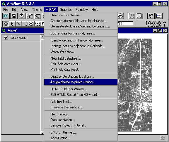
using HTML and Visual Basic. All the customized functions are grouped under a menu named WRAP (fig.1).
Each menu links to a number of prompts and dialogs designed with a friendly interface.
Figure 1. The user interface implemented as a new Menu in the View GUI.
The functions are grouped by category.
Creation of new Spatial Datasets
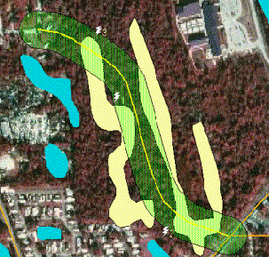
Figure 2. Examples of the utilities for creating a road centerline (yellow) and
the buffer of interest (green).
The wetland layer is shown in cyan. Wetlands intersecting the buffer are shown in yellow.
- A utility for delineating one or more wetlands on screen with a mouse.
- A utility for creating points that represent photographic stations around wetlands where photographs
of wetlands were taken in the field. The utility creates links between each point and the
corresponding photograph (fig. 3).
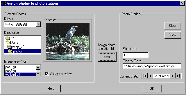
Figure 3. A dialog used to associate photo stations to corresponding photographs
from the field.
The photos are selected on the left panel and assigned in the right panel.
Spatial Operations
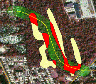
Figure 4. Identifying wetlands in the buffer area. Wetlands within the buffer area are shown in red.
- A facility to identify adjacent landuse to the wetland of interest.
Creation of the Evaluation Database
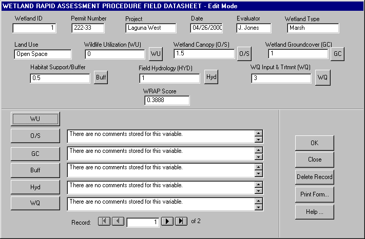
Figure 5. Main evaluation form - Field Datasheet. This dialog is created using ArcView's Dialog Designer
Reporting
Utility Tools
Documentation in HTML:
Most of the information that the WRAP analysts are required to consult as part of the preparatory work in the office is available through the Florida Geographic Data Library (FGDL). FGDL is a mechanism for collecting, standardizing and distributing GIS data for the entire state of Florida on CD-ROMs (See http://www.fgdl.org for more information). A number of layers in FGDL needed by WRAP include: National Wetlands Inventory, Habitat and Landcover, Specific Soils, Hydrology, Land Use, Aerial Photography, FDOT Roads, Strategic Habitat Areas and many more. GeoPlan Center has developed an ArcView extension that allows viewing of FGDL CD-ROMs through a user-friendly interface. Spatial information on wetland boundaries is found in several of the above layers such as National Wetlands Inventory, Land Use, Habitat and Landcover and Hydrology.
Worth mentioning in this paper is our effort to implement a component architecture approach in
the internal design of the program. Even though the application currently is designed to work as an
ArcView Project as opposed to an extension, some of the utility tools provided have been developed as
independent generic extensions that are loaded and unloaded as needed. This allows the reuse of these
components in other similar applications.
Another feature of the design was the integration of the application with other external programs
such as Notepad, Microsoft Word and the machine's default Internet browser. In addition, some of
the functions have been partly programmed in Visual Basic and integrated with ArcView using Dynamic
Data Exchange.
During the development of the WRAP application we learnt many lessons that will be of value in the development of future applications: breaking up the application in reusable components, integration of ArcView applications with external programs, and ways to get around ArcView limitations regarding GUI development.
The WRAP application has proven to be a valuable tool in assisting the environmental scientists with the wetland evaluation. FDOT and GeoPlan Center at University of Florida have organized a hands-on training course for the various wetland analysts from state agencies and private sector. They all evaluated the WRAP application as a useful tool in their environmental permitting activities. FDOT District Two has successfully used the WRAP application in one of their most recent projects. It is our hope and aim that many more entities such as US Army Corps of Engineers, Florida Water Management Districts and others will find the WRAP application useful and will incorporate it in their permitting activities.
Additional improvements to the WRAP application could include the following:
See WRAP application web page at http://www.geoplan.ufl.edu/projects/fdot/wrap.html for more information.
This project is a collaborative effort of GeoPlan Center, University of Florida and Florida Department of Transportation, Central Environmental Management Office. The authors would like to acknowledge the support of Leroy Irvin, Manager and Robert Crim, P.E. State Project Development.
Miller E. R., Jr., Gunsalus E. B., 1997. Wetland Rapid Assessment Procedure. Technical Publication REG-001. Natural Resource Management Division, Regulation Department, South Florida Water Management District, September 1997.
Author Information:
Ilir Bejleri, Ph.D.
Assistant Scientist, GeoPlan Center
Department of Urban and Regional Planning
University of Florida
431 Architecture Building
Gainesville, FL 32611
Phone: (352) 392-0997 ext. 432
Fax: (352) 392-3308
Email: ilir@geoplan.ufl.edu
Juna Papajorgji
Researcher, GeoPlan Center
Department of Urban and Regional Planning
University of Florida
431 Architecture Building
Gainesville, FL 32611
Phone: (352) 392-2056
Fax: (352) 392-3308
Email: juna@geoplan.ufl.edu
Paul Zwick, Ph.D.
Associate Professor, Interim Chair and GeoPlan Center Director
Department of Urban and Regional Planning
431 Architecture Building
Gainesville, FL 32611
Phone: (352) 392-0997 ext. 427
Fax: (352) 392-3308
Email: paul@geoplan.ufl.edu
Josh Boan,
State Wetland Programs Coordinator
Florida Department of Transportation
Environmental Management Office
Phone: (850) 922-7208
Fax: (850) 922-7217
Email: joshua.boan@dot.state.fl.us